Water Canyon to White Wave (help & invite)

Ross

Member
Joined
May 18, 2012
Messages
295
Route questions and an invite should anyone want to join 2 of us in Oct (9-12 hr hike apparently)

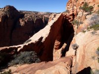
We ere going to hike to the White Wave. Kelsey's book describes the route going up Squirrel Creek, but he drops in a line you can go up Water Canyon too, which seems firstly shorter and secondly more scenic, so I don't know why he describes Squirrel Creek unless Water is difficult for hikers..

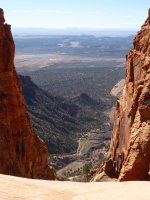
Is it relatatively easy to hike/scramble up - or perhaps down - Water Canyon towards White Wave bearing in mind I'm not a climber, hence not too happy with exposure and I don't use ropes?

And is the route-finding up/down Water Canyon fairly easy? (I wlll have GPS, compas sfor up on the top) Ideally I'd do a Water/Squirrel loop for different scenery, but if it's hard to pick the route sometimes it's better to go back the way you came, rather than searching out unfamiliar ways if it's a long day and light could become an issue.

And would either of these questions make a difference to difficulty and route-finding if I went up through Water Canyon for a clockwise loop or down through Water if I went anti-clockwise
 
PB100036.JPG P1020221.JPG P1020227.JPG PB100059.JPG If you're talking about Canaan Mt. it depends on what you want to see. If you want to see the arch, go up squirrel. It's also easier to go up squirrel then water so for a loop, I always choose that way. The route finding especially by squirrel can be tricky as there are old ATV trails and many footprints leading in wrong directions. Check out Bo and Tanya's site (or their book) for great route descriptions. http://www.zionnational-park.com/hiking-zion-national-park.htm
Water has scrambling here and there but nothing with ropes. There is one maybe 4 foot high ledge to get up and down that you should just look for the finger hold on the way up and put your pack down first on the way down if you want to make it easier. Otherwise just steep and there will be sand on top. Absolutely worth it though! I attached a couple of pictures of the arch, notch, windlass, and white domes.
 

Attachments

  • PB100036.JPG
    PB100036.JPG
    140.1 KB · Views: 15
  • P1020221.JPG
    P1020221.JPG
    107.5 KB · Views: 15
  • P1020236.JPG
    P1020236.JPG
    196.8 KB · Views: 16
Thanks for reply. Is Squirrel Creek scenic and worth doing. We might just go up and back Water Canyon to save time and maybe divert at the top to the arch?
Second question. Presumably it's not wise to go up Water Canyon if rain is forecast as it's name suggests it could mean trouble, or is there always an escape to high ground
 
Squirrel follows an old ATV trail at first then heads up a canyon. Once it heads up it is really pretty, especially in the fall. It is much harder to route find than Water though. Water starts out in a area that's more enclosed then follows a wash for awhile. Mostly everywhere there would be places to get high. If you were canyoneering the actual Water Canyon, that's different of course. The arch is kind of hard to find.

Beginning of WaterPB100076.JPG
 
Just wanted to get back to you to make sure you knew that there was severe flooding in the Hildale area a few weeks ago. I'm not sure how the road is going to Water Canyon. Please check before your trip.
 
Hi cmgz. Not sure if I ever saw your last post here, or if I thanked you for it, but anyway the road was good (a bit sandy in places), and we went up and down Water to the Windlass, camped at White Domes and back down Water. You may have seen my TR here.
If was fantastic & I'm tempted to go up again as we didn't go to the Arch and from the White Wave we headed west, whereas I gather there's a dome to the east with some very nice hoodoos which I didnt get to see, nor did I see the arch.
Would probably try Squirrel for a change next time, so 3 questions:

1. Time wise, how much longer does it take to get to the top via Squirrel compared to Water as the route looks a few miles longer as I think you leave your car nearer to Hildale.
2. When you said the route finding is hard because of ATV trails and footprints, did you mean before you start ascending, or near the top, or actually as you're ascending the cliffs of the canyon (I don't like going through the scrub on the cliffs thinking you're following the trail, finding a vertical section, and sometimes struggling to get back to where you lost the trail)
3. Finally, when we got to the top, we dropped to a valley, sort of turned 90 degress left to walk up it, then turned 90 degrees right to walk up a slickrock valley to the White Wave Domes. But if I went up Squirrel and wasn't bothering to go as far across as the White Wave Dome I wondered if you can take a more direct route hugging the upper parts of Water Canyon as the slickrock looked steep ie drop off what I may call the higher plateau (same altitude as the White Wave), to the valley I'm talking about, which is the bit I'm not sure is possible, before ascending through the trees and bushes for a short while to the point where you find the trail that heads down Water Canyon


Glad you enjoyed it! The road is now really good. They fixed it up after the flooding. There's wooden fencing at the parking areas so you can find the squirrel parking area easily. It's on the right, before the water canyon parking.
It takes longer going up Squirrel, I'd say 11-12 hours but not because of the parking, that's only about a 1/2 mile away.
First place to get lost is after you've gone down the ATV road and come to a crossing. Go straight not right or you'll go up short creek and end up too far down canyon.
P1030110.JPG

You'll go up a canyon then find a trail leading up to the top. The Beehive is by your side.P1030118.JPG

PB100010.JPG

Once you get up top there's a place that the old road looks like it leads you right, that's not the way. You have to go a little left and it doesn't look like the way, but it is. Wish I had a picture but I don't.

Next landmark is the big red slickrock. You laugh , saying there's a lot of those but once you see it you'll know.
PB100029.JPG

After making your way past this you'll be by water canyon. The way to the arch is to follow the near side. I've only been there once and would have to search myself.
PB100032.JPG

When you come back, look across for the white domes, so you know where you're headed. You'll go up a big slickrock ramp then make your way toward the domes at the top.
As far as I know (and I asked my son who has been up there lots more than me) no shortcut.
Safe hiking and enjoy! Your GPS should be really handy as well. Also, squirrel is really pretty in the fall.
 
thanks. Might not have made myself clear. But I was wondering if after visiting the arch you can get to the trail down Water Canyon WITHOUT going across as far as the White Domes i.e. if it is possible, which I think your son thinks it isn't, you'd have to be going down slick rock by the very upper part of Water Canyon on the west side of the head of Water.
 
thanks. Might not have made myself clear. But I was wondering if after visiting the arch you can get to the trail down Water Canyon WITHOUT going across as far as the White Domes i.e. if it is possible, which I think your son thinks it isn't, you'd have to be going down slick rock by the very upper part of Water Canyon on the west side of the head of Water.
Don't think so. I've gotten ledged out up there before and personally wouldn't try it. If you do, please take care.
 
Similar threads
Thread starter Title Forum Replies Date
H Access to Grand Gulch via Water Canyon Trip Planning 2
B In Government Trail and out Water Canyon Trip Planning 3
F Stevens Canyon/southern escalate water availability. Trip Planning 16
W 9 Days Solo Escalante Loop in October (water advice) - Stevens Canyon, Baker Route over Waterpocket fold, Halls Narrows to Moody Canyons Trip Planning 11
M Dark Canyon Complex Water Data Trip Planning 4
C Paria Canyon water source - August 2020 Trip Planning 2
regehr Water higher up in Virgin Springs Canyon? Trip Planning 17
Mikjik86 Desert Canyon/Water Shoes? Gear 9
gnwatts Water Canyon on Cedar Mesa Backpacking 11
gnwatts Water Canyon (Cedar Mesa) top down General Discussion 11
O Green River/Stillwater Canyon question regarding water Trip Planning 3
blueeyes Black Canyon Water Trail On The Water 16
RyanP Little Wild Horse tips for this weekend? Deep cold water in canyon? Trip Planning 5
Jackson Slickhorn Canyon Access and Water Trip Planning 8
M First Time Flat Water - Stillwater Canyon On The Water 4
ram Water Canyon 12-25-16 Canyoneering 13
M Water purification in Paria Canyon? Trip Planning 2
Dave Flash flood fatalities at Water Canyon General Discussion 15
Red Rock Rangers Water Canyon Hiking & Camping 0
Blake Merrell Canyoneering Water Canyon Canyoneering 6
cmgz Pine Valley Mts.-Water Canyon to Mill Creek Backpacking 0
steve Maze help needed: Route into Water Canyon from Chimney Rock? Trip Planning 9
Bob Backpacking into Shangri-la Canyon into Grand Gulch and out Water Canyon Resource Discussions 10
C Horseshoe canyon and Water Canyon (Canyonlands) Trip Planning 11
steve Reliable Water sources in Horeshoe Canyon? General Discussion 9
Nick The Maze: Spanish Bottom to Water Canyon Backpacking 39
Dave Water Canyon/Canaan Mountain, March 16, 2012 Hiking & Camping 20
Janice Caching water? General Discussion 8
Bob 206 mile water trail Trip Planning 0
kwc Smoke on the water … fire in the sky … General Discussion 6
JBG Water Beta 2022 - Highline Trail Trip Planning 6
regehr potable water in Escalante town? Trip Planning 6
regehr water in lower muley twist? Trip Planning 0
Janice Water questions - Escalante area Trip Planning 38
Nethos Another water post(Bowdie/Midway) Trip Planning 10
CodyL Winds- Big water slide Trip Planning 3
RyanP Sawyer Squeeze questions: how to pre-filter, and recommended dirty-water bag? Gear 30
Gretchen Millward Trachyte Creek conditions/water Trip Planning 0
Christo Water availability:Thorofare Yellowstone Trip Planning 6
RyanP road from Hite to Water Hole Flat Trip Planning 20
JBG Water on the Highline Trail - 2021 Trip Planning 2
garyhost Cedar Mesa Utah Trip. Conditions? Water? Trip Planning 8
RyanP Conditions (water/bugs) for Escalante/Death Hollow Trip Planning 27
J Grand Gulch (Kane to Bullet) Water Availability Trip Planning 9
E Water in the Needles early-May 2021 Trip Planning 3
S Packrafting Escalante - FiftyMile Creek and low water level Lake Powell Trip Planning 8
gnwatts Grand Gulch water Trip Planning 6
P Salt Creek water Backpacking 2
P Pitchstone Plateau water Backpacking 7
OldBill Water treatment tablets and Cryptosporidium Gear 15

Similar threads

Back
Top