Water Canyon on Cedar Mesa

gnwatts

Member
.
Joined
May 19, 2012
Messages
1,943
DSC04377.jpg


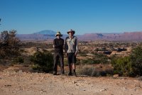
I have been here before @ the end of the road, years ago. I was curious to see where Slickhorn Road ended. I was not very impressed, evidently, as I had not been back. I have been most places on Cedar Mesa, the exception being this small canyon system, Water Canyon. I had been to the mouth of this canyon on my way down Grand Gulch once. We only went a little ways up.

BTW Thanks to @mike_offerman and @Bob for info on this hike.

I stuck my head out of my tent that 1st morning, and I was immediately glad I was here. It was in the low 30's with no wind, and it would heat up to about 50 that day. Perfect, as long as you were in the sun.

DSC04390.jpg


DSC04392.jpg


Our plan was to head SW for the head of the southernmost canyon, and work our way north. We wanted to find a different way into the canyon system. All of the canyons were inaccessible to us (at least to me). We tried to find the route described by Mike and Bob but we could not see it. So we headed that canyon and headed west, where we found this little side canyon. We had to take our packs off 3 times, a little sketchy at times but not too bad.


DSC04357.jpg


DSC04396.jpg


GoogleEarth_Image.jpeg


The head of the southernmost canyon:

IMG_2698.JPG


IMG_2700.JPG


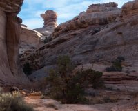
Looking towards the canyon we hoped to enter:

IMG_2702.JPG


After a slightly scary descent, we were in a sandstone paradise, pools, cottonwoods, pinons and silence.

IMG_2708.JPG


IMG_2715.JPG


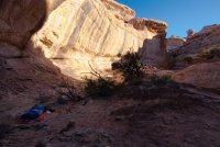
We came upon this drop off, easy to negotiate along the creek bottom. We decided to stop for a break, then we decided to stay here for 2 nights. It was a beautiful place to camp. This canyon has an intimacy, a scale, that does not make you feel small.

DSC04432.jpg


DSC04411.jpg


DSC04511.jpg


DSC04444.jpg


Next morning:

DSC04462.jpg


We had sun very early. Very nice.


DSC04479.jpg


DSC04491.jpg


I did not really want to go on a day hike. I would happy exploring our immediate surroundings, but I wanted to see if we could reach the mesa via a side canyon below. It's always nice to have a good loop hike.
This is the little fall below our camp, on our way down canyon:

DSC04504.jpg


DSC04399.jpg


At the junction with the side canyon on the right LDC. We went up maybe 1.5 miles. It was a fun hike, fun route finding.

DSC04540.jpg


DSC04549.jpg


DSC04559.jpg


DSC04593.jpg


DSC04604.jpg


DSC04588.jpg


This was where we turned around. Maybe there is a way out. Maybe not.


DSC04636.jpg


Next morning:

DSC04668.jpg


DSC04474.jpg


Gotta go home. Packing up:

DSC04716.jpg


The hike out:

DSC04721.jpg


Looking back at our canyon:

IMG_2734.JPG


IMG_2735-1.JPG


IMG_2740.JPG


Back at the end of the road.

IMG_2750.JPG


I am happy to have spent some time here. There is more to see.
Greg
 

Attachments

  • DSC04396.jpg
    DSC04396.jpg
    351 KB · Views: 32
  • DSC04653.jpg
    DSC04653.jpg
    366.1 KB · Views: 30
  • DSC04479.jpg
    DSC04479.jpg
    337 KB · Views: 28
Last edited:

Bob

Trailmaster
Joined
Mar 3, 2013
Messages
3,748
Nice pics. So........ was what I indicated the only way down? Your track doesnt show anything else....
 

Miya

Because I am able.
Joined
Dec 31, 2017
Messages
1,404
Great share! Thanks!

Did you cowboy camp in 30 degree weather?! I would be freeeezing haha. :cold:
 

gnwatts

Member
.
Joined
May 19, 2012
Messages
1,943
Nice pics. So........ was what I indicated the only way down? Your track doesnt show anything else....

I don't know. We went down the small side canyon to the north of that main canyon.

Great share! Thanks!

Did you cowboy camp in 30 degree weather?! I would be freeeezing haha. :cold:

It wasn't too bad, I was quite comfortable. :)
 

Ugly

Life really is better Here
.
Joined
Apr 20, 2013
Messages
1,170
I especially like the b&w of the undercut walls that look like they were near camp. Really cool report!
 

gnwatts

Member
.
Joined
May 19, 2012
Messages
1,943
Thanks everyone for your comments.

I especially like the b&w of the undercut walls that look like they were near camp. Really cool report!

I really love the winter sun, it's angle creates the shadows and textures I like.
 

Ugly

Life really is better Here
.
Joined
Apr 20, 2013
Messages
1,170
Thanks everyone for your comments.


I really love the winter sun, it's angle creates the shadows and textures I like.

Especially in the desert. I got to enjoy a bit of it for a few days this weekend.
Your reports are always great.
 
Similar threads
Thread starter Title Forum Replies Date
gnwatts Water Canyon (Cedar Mesa) top down General Discussion 11
H Access to Grand Gulch via Water Canyon Trip Planning 2
B In Government Trail and out Water Canyon Trip Planning 3
F Stevens Canyon/southern escalate water availability. Trip Planning 16
W 9 Days Solo Escalante Loop in October (water advice) - Stevens Canyon, Baker Route over Waterpocket fold, Halls Narrows to Moody Canyons Trip Planning 11
M Dark Canyon Complex Water Data Trip Planning 4
C Paria Canyon water source - August 2020 Trip Planning 2
regehr Water higher up in Virgin Springs Canyon? Trip Planning 17
Mikjik86 Desert Canyon/Water Shoes? Gear 9
O Green River/Stillwater Canyon question regarding water Trip Planning 3
blueeyes Black Canyon Water Trail On The Water 16
RyanP Little Wild Horse tips for this weekend? Deep cold water in canyon? Trip Planning 5
Jackson Slickhorn Canyon Access and Water Trip Planning 8
M First Time Flat Water - Stillwater Canyon On The Water 4
ram Water Canyon 12-25-16 Canyoneering 13
M Water purification in Paria Canyon? Trip Planning 2
Dave Flash flood fatalities at Water Canyon General Discussion 15
Red Rock Rangers Water Canyon Hiking & Camping 0
Blake Merrell Canyoneering Water Canyon Canyoneering 6
cmgz Pine Valley Mts.-Water Canyon to Mill Creek Backpacking 0
Ross Water Canyon to White Wave (help & invite) Trip Planning 8
steve Maze help needed: Route into Water Canyon from Chimney Rock? Trip Planning 8
Bob Backpacking into Shangri-la Canyon into Grand Gulch and out Water Canyon Resource Discussions 10
C Horseshoe canyon and Water Canyon (Canyonlands) Trip Planning 11
steve Reliable Water sources in Horeshoe Canyon? General Discussion 9
Nick The Maze: Spanish Bottom to Water Canyon Backpacking 39
Dave Water Canyon/Canaan Mountain, March 16, 2012 Hiking & Camping 20
kwc Smoke on the water … fire in the sky … General Discussion 6
JBG Water Beta 2022 - Highline Trail Trip Planning 6
regehr potable water in Escalante town? Trip Planning 6
regehr water in lower muley twist? Trip Planning 0
Janice Water questions - Escalante area Trip Planning 38
Nethos Another water post(Bowdie/Midway) Trip Planning 10
CodyL Winds- Big water slide Trip Planning 3
RyanP Sawyer Squeeze questions: how to pre-filter, and recommended dirty-water bag? Gear 30
Gretchen Millward Trachyte Creek conditions/water Trip Planning 0
Christo Water availability:Thorofare Yellowstone Trip Planning 6
RyanP road from Hite to Water Hole Flat Trip Planning 20
JBG Water on the Highline Trail - 2021 Trip Planning 2
garyhost Cedar Mesa Utah Trip. Conditions? Water? Trip Planning 8
RyanP Conditions (water/bugs) for Escalante/Death Hollow Trip Planning 27
J Grand Gulch (Kane to Bullet) Water Availability Trip Planning 9
E Water in the Needles early-May 2021 Trip Planning 3
S Packrafting Escalante - FiftyMile Creek and low water level Lake Powell Trip Planning 8
gnwatts Grand Gulch water Trip Planning 6
P Salt Creek water Backpacking 2
P Pitchstone Plateau water Backpacking 7
OldBill Water treatment tablets and Cryptosporidium Gear 15
I Water in Frisky Creek south of Highway 12 in the Grand Staircase? Trip Planning 0
DrNed Water Sources McKee Draw to Leidy Peak Trip Planning 12

Similar threads

Don't like ads? Become a BCP Supporting Member and kiss them all goodbye. Click here for more info.

Top