Hey Everyone
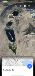
I am planning a trip into the Washakie Wilderness, and was hoping to access the South Fork Shoshone via Shoshone Pass and East DuNoir Creek just NW of Dubois. The topo maps indicate a 4WD road up to Trail Lake, with access to Trail #809, but I haven't been able to find much information online about this access point to the wilderness area. Does anyone have any experience with this area? The roads appear to be public, but there are several ranches in the area, so I am wondering about access issues as well as just general information.
For reference, Trail Lake is located approximately at: 43.7305, -109.8098
Many Thanks!