Utah County Hikes

Nick

-
.
Joined
Aug 9, 2007
Messages
12,949
I'm looking for recommendations on hikes to do in the Utah County/Wasatch County areas for my trail guides project. I need a wide variety ranging from paved to short, easy hikes to longer more difficult ones. So far I have these on my radar:

Super easy:
Cascade Springs (Midway)
Canyon Nature Trail (AF Canyon) - Has anyone done this?
Hobble Creek Parkway (paved)

Easy:
Stewart Falls
Deer Creek Trail
Grotto Falls
Big Spring Hollow

Moderate:
Pittsburg Lake

Difficult:
Timp

I really need more in the Easy or Moderate category in particular. Any suggestions would be greatly appreciated. Actually, any suggestions anywhere along the Wasatch that has good, doable hikes right now is appreciated.
 
Pioneer Peak via Snake Creek (Midway) short but steep. I would rate it moderately difficult.

Battle Creek Falls via Pleasant Grove. Easy

Little Baldy on the West side of Timp via Dry Fork. Moderate
 
easy: rock canyon
moderate: silver lake (AF Canyon)
moderate: horesetail falls (dry creek/Alpine area, still snowy for the next couple weeks)
moderate: 41/40 loop up AF Canyon
difficult: Lake Hardy. 5000 feet elevation gain in 4.7 miles
difficult: Lone Peak. Steep and exposed
moderate: big baldy loop in PG
moderate: Y trail

It's not Utah Valley, but the trails in corner canyon are great for beginners.
 
Last edited:
Cascade Saddle via Rock Canyon campground. Difficult to Moderate.

Buffalo Peak via Squaw Peak Road. Super easy

Squaw Peak.
 
Provo Peak. Difficult. Something like 4,000 feet in 2 miles.

Bonneville Shoreline trail starting at the Bridal Veil falls parking area. Go as far as you want so it could be easy or difficult.
 
5th water hot springs (though I think you already have a guide for that?)

Super Easy: Horse Flat (up af canyon near the summit)

easy: there's a trail that connects Aspen Grove to the summit parking lot. I can't remember the name of that trail.

moderate: paved trail to timp caves
 
good call. The view is really crappy, there are tons of bugs, no usable camp sites, very few water sources, and just a muddy swamp really. Definitely not worth the hike.
 
How high do you guys think I can hike up there right now before hitting snow or areas that haven't greened up yet? Particularly in AF canyon and up along the Squaw Peak road.
 
Last year I hiked up the Squaw Peak road at the end of April, they still had the gate to the campground closed. I ran into snow near the top, but it wasn't more than a few inches. The meadows were mostly clear, I probably could have made it to Buffalo Peak pretty easily. I've been a total slacker and am getting a late start on hiking this year, so I haven't gotten up there this year yet. I would imagine you could make it, there seemed to be more snow this year, but it's also a month later than when I did it last year.
 
Looking at Stewart Falls, it looks like it's kind of split between doing it from Aspen Grove or Sundance. Anyone have an opinion on that? And would it be pretty easy to stash a bike at Aspen Grove and ride it back to Sundance (I'm hoping it's mostly downhill)?
 
aspen grove to sundance is donwhill, but that canyon road is sketchy on a bike. If mountain biking, you could take the dirt trails down.
 
easy: there's a trail that connects Aspen Grove to the summit parking lot. I can't remember the name of that trail.

I believe this is called Lame Horse #55. This is where I had my motor bike encounter last year. Definitely easy and a great trail if looking to escape summer sun. Shaded by dense vegetation much of the way and the trail is soft under the feet. Seriously, a whole book could be written on all the trails accessible from American Fork Canyon and Alpine Loop...and probably already has.

How high do you guys think I can hike up there right now before hitting snow or areas that haven't greened up yet? Particularly in AF canyon and up along the Squaw Peak road.

I will likely be attempting Buffalo Peak through Rock Canyon from my house on Wednesday and will report back. I tried for it from Bridal Veil about a month ago and started to hit snow right at Hope Campground and the Squaw Peak Road. Between Little Rock Canyon Overlook and Buffalo the snow was still a good 3-4 feet deep and not having snowshoes, I had to turn around. I ended up scrambling and bushwacking down through Little Rock Canyon before landing a trail further down. You can see my report of that adventure on my blog. I'm sure much of the snow has melted out now, but I'll bet there are still some good drifts still sitting there between Little Rock and Buffalo.

And to add to the above lists:

Y mtn/Slide Canyon/Y mtn overlook - Moderate. Switchbacks to the Y still burn my legs up
Slate Canyon - Moderate. Can be hiked as loop with Y mtn/Slide Canyon or Rock Canyon for an extended loop
Little Rock Canyon (between Rock Canyon and Provo Canyon) - Moderate to Difficult (Some class 2). Some great little campsites for those seeking a "quick" up and back overnighter, but not easily accessed as there is no parking lot or actual trailhead for it and you must cut up through a neighborhood....in fact, let's just keep this place a secret as well. ;)
Spanish Fork Peak - Difficult (Steep)
Loafer Mountain/Santaquin Peak - Moderate
Nebo
via North side (Payson Canyon) - Moderate to difficult with a bit of exposure. South side is longer, more exposed, and thus a bit more difficult from what I read. Can actually bag 3 peaks right along the ridge if you don't mind the scrambling and exposure.
Big Springs (South Fork Provo Canyon) - Easy. Becomes moderate to difficult after Big Springs up to ridge.
GWT/#33 via Canyon Glen Park (Provo Canyon) to Rock Pile Monument junction - Easy, Can become more moderate if you push on up to Big Baldy. Can also swing out and over to Dry Canyon, down to BST, and elsewhere from the Rock Pile.
Grove Creek - Easy but some slight exposure

I hiked the last one as a loop with Battle Creek last week and didn't encounter any snow but there were traces up around Big Baldy and those traces are probably gone now. There are dozens and dozens of very enjoyable and scenic hikes in and accessible via Utah County and this one remains one of my top 5 for the area. The others being: Timp (either TH), Rock Canyon/Squaw Peak/Cascade/Provo Peak, Dry Creek (Alpine), & Loafer Mtn/Santaquin Peak. I've yet to do Nebo and Spanish Fork Peak but aim to cross those off this year. Grove Creek used to be one of those lesser used trails known mostly to just locals as well, but since a paved road, parking lot, and proper trail head have been installed in recent years, it has become much more popular. If you ever hike it, you'll certainly see why. While I'm happy it's more maintained and more accessible now, I'm also bummed that it has significantly increased the traffic up there. Of course, I have a hammock now, so the sites are much less limited for me now. Perhaps I'll post my own report of it. Before the trailhead was made more accessible, it was Battle Creek taking up all the traffic leaving Grove Creek to those who sought more isolation. You can also hike the "G" from the Kiwanis Park at the Battle Creek Trailhead...a great alternative to the high traffic "Y" with similar views of Utah Valley and the Lake.

Update - After reading the original post a little bit closer, I've "green lighted" the ones in my list that are completely free or would be mostly clear of snow right now.
 
Last edited:
+1 on the Baldy. I like that one because of the variety of scenery, when going up Battlecreek canyon.

Another would be Curly Springs Trail #51. It spurs off the Battlecreek Canyon trail about 1.5 miles up.
image.jpg

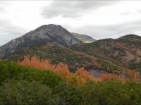
This is last Labor Day from the top of the curly springs trail looking north. The highest peak is Mt Mahogany or "G Mountain" Easy to moderate hike.
 
On the other side of utah lake in Saratoga springs is a 16-20 miler (depending on if you checkout the towers) that goes on the dirt road from Redwood and Soldier Pass to Lake Mountain Comm Rd and comes out Israel Canyon. It goes to the top where all those towers are.
It's mostly used by ATVs but we use it as our Boy Scout 20 miler trail.

And the trail from Sundance to Stewart falls is a bit longer, but more enjoyable. From Sundance it's flatter, from aspen grove it's rocky and steep in some sections. And parking at Sundance is free where aspen grove you have to pay the fee at the gate.
 
Similar threads
Thread starter Title Forum Replies Date
hatchcanyon Utah Emery County: Clay Hills Road aka Wild Horse Road Off Road 4
steve Invite July 25-26 Utah County Overnighter - Dry Fork to Horsetail Falls to Box Elder Peak to Silver L Flats Meet Up (Members Only) 4
B Southern Utah March suggestions? Trip Planning 5
desertvic Howdy from rural Utah Noobs: Introduce yourself! 1
Ugly Floating Island- Utah Trip Planning 8
Normie Invite Looking for shuttle partner -- two trips in Southern Utah Meet Up (Members Only) 5
J Identify the spot Utah: I don't know where it is General Discussion 2
BeardoMcGrath Oh look yet another Utah conditions thread: mid May 2023 Trip Planning 9
Vegan.Hiker 8 day trip to Utah Trip Planning 10
ww.joedirt.do Hello from Utah! Noobs: Introduce yourself! 0
Martyn Hi from Hurricane Utah! Noobs: Introduce yourself! 1
B Good trips in Southern Utah given current conditions Trip Planning 26
saltybird SE Utah NPs in April Trip Planning 12
C Grand Gulch Cedar Mesa Utah 11 Day Backpack October 2022 Backpacking 10
T Amazing Discovery in Utah-Glen Canyon Trip Planning 65
V four day backpacking trip in southern Utah starting this weekend Trip Planning 4
regehr recent Utah meteorite General Discussion 0
TrailScot "I Would Walk 500 Miles ..." - A Utah Adventure - April 2022 - Final Part Backpacking 11
TrailScot "I Would Walk 500 Miles ..." - A Utah Adventure - April 2022 - Part 5 Backpacking 3
TrailScot "I Would Walk 500 Miles ..." - A Utah Adventure - April 2022 - Part 4 Backpacking 10
TrailScot "I Would Walk 500 Miles ..." - A Utah Adventure - April 2022 - Part 3 Backpacking 4
TrailScot "I Would Walk 500 Miles ..." - A Utah Adventure - April 2022 - Part 2 Backpacking 5
TrailScot "I Would Walk 500 Miles ..." - A Utah Adventure - April 2022 - Part 1 Backpacking 6
Rudolf_The_Red Hello from BFE, Utah! Noobs: Introduce yourself! 4
H location of thirteen faces-horse canyon Utah Hiking & Camping 4
TrailScot Dripping Canyon to Grand Gulch, Cedar Mesa, Utah - March 2022 Hiking & Camping 7
H Horse Canyon needles district Utah Off Road 0
S Howdy from Utah!! Noobs: Introduce yourself! 0
D jackets found in southern Utah Noobs: Introduce yourself! 0
kwc Southern Utah Accommodations Question General Discussion 10
C Utah Mountains in Late May Trip Planning 12
CodyL Southern Utah in January Backpacking 14
T Southern Utah Backpacking ideas for MLK Weekend? Trip Planning 21
U greetings from southwest Utah Noobs: Introduce yourself! 3
Jumper84 Hello from Kearns, Utah Noobs: Introduce yourself! 0
Parma The Best Arch in Utah is... General Discussion 20
Jazerrad Parunweap Canyon / The Barracks (Utah) Trip Planning 4
TrektheWorld Utah Trip - last weekend of October 2021 Meet Up (Members Only) 2
garyhost Cedar Mesa Utah Trip. Conditions? Water? Trip Planning 8
GramaNana Newbie Overnight with REI gear - Farmington, Utah May 2021 Hiking & Camping 12
GramaNana Seeking Short Overnights in Utah General Discussion 5
AnneMarieO Food protection in SE Utah? General Discussion 2
GramaNana Hello from Utah - future GWT hiker Noobs: Introduce yourself! 11
norwegianxplorer In the shadow of the Henry Mountains, Utah Backpacking 2
Windy What is this? Geoglyphs in utah Hiking & Camping 5
Rockskipper New Utah State Park General Discussion 0
regehr 2001: A Space Odyssey in Utah General Discussion 142
Nethos Southern Utah - Late October & Early November 2020 Trip Planning 16
Mikjik86 Utah loosening restrictions? General Discussion 4
seekinglost Desolation Canyon, Utah... Any info? Trip Planning 24

Similar threads

Back
Top