Upper Bowdie loop

Kullaberg63

Member
Joined
Mar 6, 2014
Messages
572
I have a very short list of hikes I might never repeat. This one got added! Why? Brush! Too bad, because I love wild and remote places like this where nobody hardly ever goes.

Followed @Bob 's track from here: http://backcountrypost.com/threads/fable-valley-bowdie-canyon.2787/

It ended up being a 10 hour day: 15 mile bike ride to and fro the TH, the last half on a nearly decommissioned track, plus the loop hike of about 13 miles.


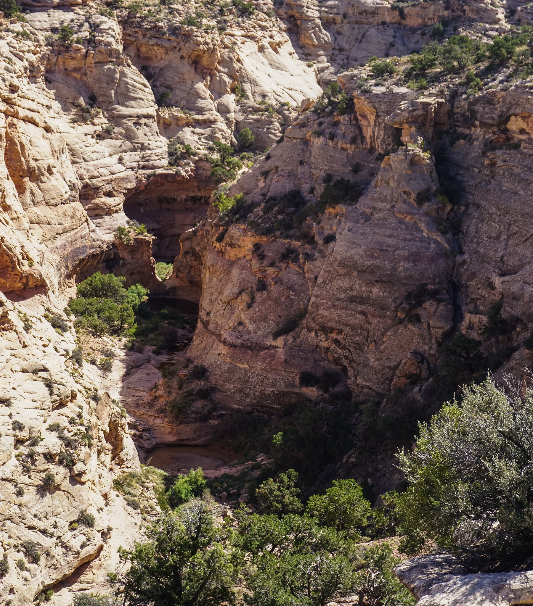
Arch near the confluence of north and south fork


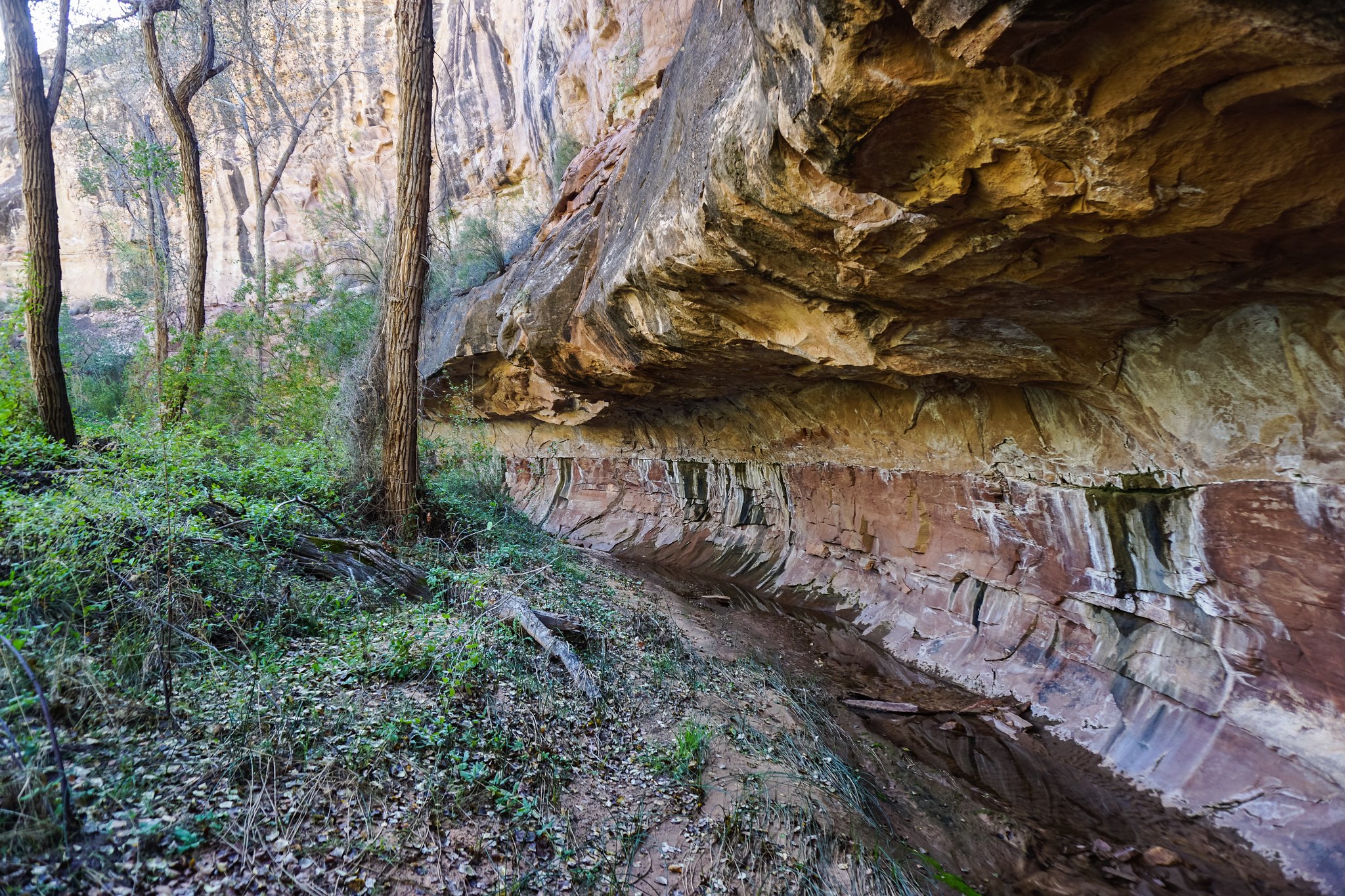
Bypassing a section of dryfalls, massive potholes and this unique 'portal'.


Lots of this, but worse.


But also some redeeming qualities.


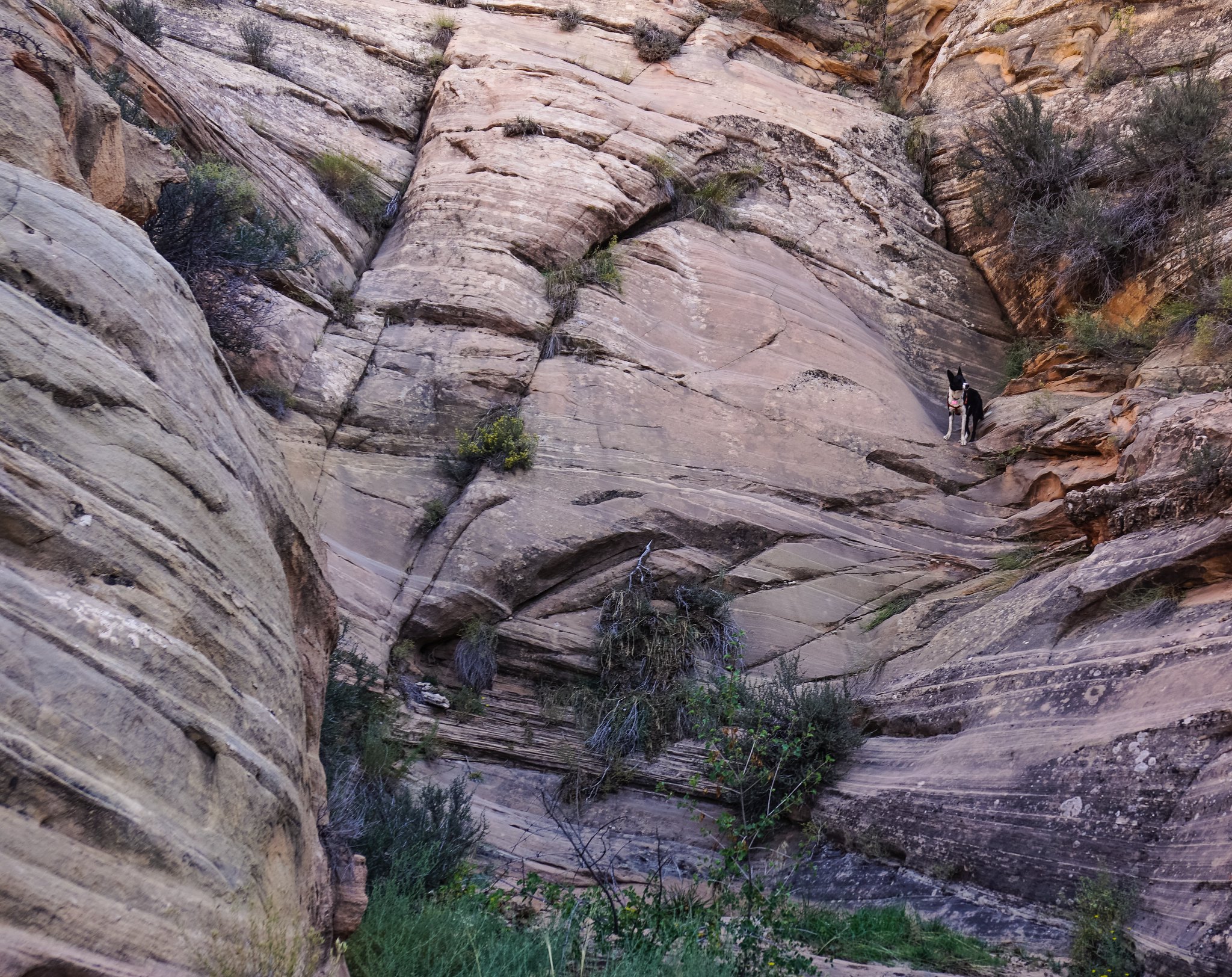
Skotti can't wait to see if this side canyon exit goes!


Featured image for home page:
slide.jpg
 

BJett

Member
Joined
May 3, 2013
Messages
556
how far down Bowdie did you go? that area fascinates me. a Bowdie/Dark/Long Canyon loop, with a packraft for the 8 mile river section, is high on my list.
 

Kullaberg63

Member
Joined
Mar 6, 2014
Messages
572
Down north fork, up south fork. At the confluence was the most heinous brush, so I didn't descend further. Supposedly lower Bowdie is incredible, with agreeable hiking too.

Yes, a packraft loop is in the works. Either involving Gypsum or Dark. Let's make it happen!

I have gone up Dark from the river, to the top of the Sundance and back. Also explored Fable. Now with this Bowdie outing I'm finally starting to get an idea of the terrain. Complex area, very fascinating. Huge and remote, for sure.
 
Last edited:

slc_dan

Desert Rat-Weekend Warrior
Joined
Jun 7, 2012
Messages
1,687
Beautiful! The bushwack does look tedious. Was there any hiding poison ivy in there? I got hit pretty bad this past June with ivy growing up willows like that.
 

BJett

Member
Joined
May 3, 2013
Messages
556
I have spent way too many hours planning this one. Parking at the airstrip on Sweet Alice Rd, descend Bowdie, float to Dark, up Dark to Long, back up Long to the airstrip. Epic! Only issues being timing as far as the road being open (early May?), and if permits would be necessary to float that 8 mile section of Cataract. A week in there might do it :)
 

Kullaberg63

Member
Joined
Mar 6, 2014
Messages
572
The road needs to be bone dry, not just free of snow. Or else you might spend more than a week down there!
 

Bob

Trailmaster
Joined
Mar 3, 2013
Messages
3,965
We went down fable valley/ gypsum to the Colorado.... Floated down to Bowdie and out on one trip.....
 

Bob

Trailmaster
Joined
Mar 3, 2013
Messages
3,965
Come on the brush wasn't that bad ....we gave dine worse. You can go down either firk of Bowdie... The best kivas around are below the confluence of the forks... Sweet Alice road is blocked by snow late up high....
No poison ivy ...

I have been thru there twice now....one ruin I want to get back and check out .....

You can drive to the canyon itself.....good road....hehe
 
Last edited:

conorfell

"trip of a lifetime, every year"
Joined
Oct 19, 2018
Messages
4
@Kullaberg63 I read your beta on another thread about your later packraft trip of Bowdie-Dark (it was very helpful thank you!) Is it fair to say you change your mind about repeating? Did you use the same TH the second time around? I've very interested in this route. Also @Bob I saw that your gps track is no longer up, any chance I could get beta on TH location and water sources. Thanks, this forum is such a great find! I'm already losing sleep to trip planning as a result.
 
Last edited:

Brendan S

Member
Joined
Mar 19, 2016
Messages
410
Bowdie below the confluence is fantastic. If you don't already have them I'd recommend picking up a couple S. Allen (probably Canyoneering 2 & 3) and M. Kelsey (don't expect handholding...he'll just give you an idea if there's a route in or out...trying to follow too closely leads to lots of frustration or worse) books. Between those and some creativity and map reading you should have plenty of info for lots of trips.
 

Kullaberg63

Member
Joined
Mar 6, 2014
Messages
572
@Kullaberg63 I read your beta on another thread about your later packraft trip of Bowdie-Dark (it was very helpful thank you!) Is it fair to say you change your mind about repeating? Did you use the same TH the second time around? I've very interested in this route. Also @Bob I saw that your gps track is no longer up, any chance I could get beta on TH location and water sources. Thanks, this forum is such a great find! I'm already losing sleep to trip planning as a result.

Actually those two trips (this one here, and the pack rafting one) take in two different parts of Bowdie, and do not overlap.

As @Brendan S says above, Bowdie below the confluence of north and south forks is pretty amazing. Above the confluence, not worth repeating. My opinion!
 

Bob

Trailmaster
Joined
Mar 3, 2013
Messages
3,965
Resource page is back up.... I could download the bowdie fable file....let me know
 

Nick

-
.
Joined
Aug 9, 2007
Messages
12,940
Yeah, sorry about the delay on the resources section but it is alive and well again. All of Bob's tracks and everything else in there is available again.
 

Bob

Trailmaster
Joined
Mar 3, 2013
Messages
3,965
Actually those two trips (this one here, and the pack rafting one) take in two different parts of Bowdie, and do not overlap.

As @Brendan S says above, Bowdie below the confluence of north and south forks is pretty amazing. Above the confluence, not worth repeating. My opinion!
There is a few nice ruins and some neat pour offs on the North fork side, found a few lithic sites on the north, South fork is pretty much just a canyon. Elk use the top end.
 

Brendan S

Member
Joined
Mar 19, 2016
Messages
410
I’ll also add that just because people online or in a book say that some part of a canyon is a thrash or bad or whatever doesn’t mean you shouldn’t do it. Some of my favorite trips had parts that people say not to do, and I wouldn’t necessarily do them again, but I’m damn happy I did. From the sounds of it you’re just getting into exploring some of the more interesting parts of the CO Plateau...just throw together some ideas and go for it.
 

Bob

Trailmaster
Joined
Mar 3, 2013
Messages
3,965
Nice ledge walk around Gypsum falls.... Make sure to check out the fortress ruin area in fable valley by gypsum
 
Similar threads
Thread starter Title Forum Replies Date
Janice Lizard Head Plateau - overlook Upper Cathedral Lake? Trip Planning 15
F Upper Escalante River Backpack conditions Trip Planning 6
J Death Valley Natl. Pk. Upper Monarch Canyon plus. Dec 1, 2021 Hiking & Camping 1
W Cow season in upper Paria canyons Trip Planning 0
TractorDoc Off Trail to Yellowstone's Aster Lake and Upper Witch Creek -- September 13, 2021 Hiking & Camping 13
TheMountainRabbit Upper Toklat River (Denali NP) - August 2018 Backpacking 7
Janice Pictured Rocks National Lakeshore in Michigan's Upper Peninsula Backpacking 6
NorthwestWanderer Backpacking the Lost River Range in Idaho : Bear Creek Lake & Upper Basin Backpacking 7
Jammer Sequoia: Upper Kern and Lake South America Backpacking 12
Janice Porcupine Mountains in Michigan's Upper Peninsula - August 2-7 Backpacking 15
CloakedInSmoke Boot upper repair Gear 7
S Backcountry camping tips for Wind Rivers - upper Green River valley via canoe Trip Planning 5
piper01 The Upper Gulch and Egg Canyon, GSENM Backpacking 6
Titans The impressive Upper Muley Twist Canyon Hiking & Camping 8
P Yellowstone, Lonestar Geyser into the upper Bechler Backpacking 2
P Yellowstone - Lonestar into the Upper Bechler and back Backpacking 14
Kullaberg63 Upper Death Hollow - blitz descent Backpacking 8
DrNed Upper Henry's Fork Lakes Trip Planning 1
Devin Ashby Upper Escalante Canyon / Death Hollow Info? Trip Planning 15
Wanderlust073 Upper Willow Lake overnight - Eagles Nest Wilderness Backpacking 4
Parma Capitol Reef, Upper Muley Twist Day Hike Backpacking 19
Parma Is the road to Upper Muley Twist doable in an Outback? General Discussion 19
DrNed North Platte & Upper Green River Trip Planning 0
Writhdar Waterpocket Canyon (Capitol Reef) non-technical access to upper part? General Discussion 1
John Goering Tobacco Root Mountains-Leggat Creek, Upper Mill Creek Hiking & Camping 1
kimbur96 First Solo overnight, Navigation Trail, Upper Priest River, Northern Idaho Backpacking 10
Joey Upper Death Hollow and the Old Bowington Road, From Hell's Backbone down to the Escalante River Backpacking 24
scatman Invite Mirror Plateau - Upper Lamar River - Hoodoo Basin - Yellowstone National Park Meet Up (Members Only) 27
Tater Head Upper Neon Canyon (conditions) Trip Planning 2
Dave Upper Muley Twist, May 23-25 2015 Backpacking 14
BJett Upper Red River - Red River Gorge Geologic Area On The Water 13
IntrepidXJ Upper Pollock Canyon Hiking & Camping 3
BJett Day 1 - Upper Calf Creek Hiking & Camping 1
ogdendude Upper Salt Creek Canyon, again Backpacking 5
A Upper Settings Trail - Uintas Trip Planning 8
IntrepidXJ Upper Calf Creek Falls Hiking & Camping 0
Udink Upper Black Box Canyoneering 10
Scott Chandler Easter Weekend Day 3: The Upper San Rafael Hiking & Camping 2
John Fowler Upper Muley Twist, again Hiking & Camping 18
Christian Little Egypt, Burr Trail, Upper Muley Twist, Escalante Slots Hiking & Camping 23
B Timpanooke to Upper Scout Falls Hiking & Camping 0
Udink Upper Old Woman Wash Hiking & Camping 2
Nick Lower Muley Twist vs. Upper Muley Twist Trip Planning 19
pstm13 Upper Salt Creek Backpacking 16
pstm13 Upper Salt Creek Canyonlands Trip Planning 3
BrettCottrell Upper Hazard & Hard Trail Creek lakes. Grassy Mountains, Idaho. Hiking & Camping 8
Jammer Upper Muley Twist from Notom Rd? Trip Planning 11
Dave Upper Muley Twist Canyon, Capitol Reef Trip Planning 0
IntrepidXJ Upper Antelope Canyon Hiking & Camping 9
powderglut Slickrock above Upper Buckskin Gulch? General Discussion 9

Similar threads

Don't like ads? Become a BCP Supporting Member and kiss them all goodbye. Click here for more info.

Top