Navigation
Install the app
How to install the app on iOS
Follow along with the video below to see how to install our site as a web app on your home screen.
Note: This feature may not be available in some browsers.
More options
Style variation
You are using an out of date browser. It may not display this or other websites correctly.
You should upgrade or use an alternative browser.
You should upgrade or use an alternative browser.
unsettled weather in an image
- Thread starter regehr
- Start date
regehr
Member
- Joined
- Mar 28, 2012
- Messages
- 2,445
is it warming or is it precip in the Escalante's drainage basin? I wasn't clear on thatNice pic.. shows a warming peak then the slowdown reflecting the snowmelt
Bob
Trailmaster
- Joined
- Mar 3, 2013
- Messages
- 4,903
Lol.... Remember I live in snow country so that's what I look at is as... May be rain thereis it warming or is it precip in the Escalante's drainage basin? I wasn't clear on that
OldBill
Member
- Joined
- Aug 18, 2015
- Messages
- 584
fossana
Member
- Joined
- Jan 11, 2018
- Messages
- 1,056
That's the only gauge between there and Lake Powell, plus it's upstream of Boulder Ck. The Boulder Ck gauge is no longer reporting. A rule of thumb is to double the flow rate at the Escalante gauge to get an estimate of the Escalante River flow rate downstream of Boulder Ck.
- Joined
- Jan 4, 2015
- Messages
- 2,896
The other thing is, it depends on lake levels. In higher water, the lake starts to back up near the mouth of Stevens.Is there a gauge further downstream? If not, any guesses on how much higher the river will be near Coyote Gulch? We're heading there in 3 weeks and hoping to go up to Stevens Arch and Canyon.
- Joined
- Dec 5, 2017
- Messages
- 1,331
Helpful - thanks.That's the only gauge between there and Lake Powell, plus it's upstream of Boulder Ck. The Boulder Ck gauge is no longer reporting. A rule of thumb is to double the flow rate at the Escalante gauge to get an estimate of the Escalante River flow rate downstream of Boulder Ck.
- Joined
- Dec 5, 2017
- Messages
- 1,331
Good to know - hadn't realized that would make a difference. Thanks.The other thing is, it depends on lake levels. In higher water, the lake starts to back up near the mouth of Stevens.
regehr
Member
- Joined
- Mar 28, 2012
- Messages
- 2,445
wow!
if anyone has insights into the likely condition of the Wolverine Loop Road and the Moody Road late next week, please let me know.
I was hoping to get to the Colt Mesa tanks to check on them, and then while there, hike down Choprock. but if these roads are blown we'll do something off the Burr Trail.
the latest GSENM road report has Wolverine as impassable but the info is 2 weeks old now https://www.blm.gov/sites/default/files/docs/2023-10/GSENM-Road-Condition-Report.pdf
Brendan S
Member
- Joined
- Mar 19, 2016
- Messages
- 433
it hasn’t been that high in many years afaikGood to know - hadn't realized that would make a difference. Thanks.
Brendan S
Member
- Joined
- Mar 19, 2016
- Messages
- 433
There’s already a lot of water out there even before this coming storm. I’d bet those tanks are plenty full.wow!
if anyone has insights into the likely condition of the Wolverine Loop Road and the Moody Road late next week, please let me know.
I was hoping to get to the Colt Mesa tanks to check on them, and then while there, hike down Choprock. but if these roads are blown we'll do something off the Burr Trail.
the latest GSENM road report has Wolverine as impassable but the info is 2 weeks old now https://www.blm.gov/sites/default/files/docs/2023-10/GSENM-Road-Condition-Report.pdf
- Joined
- Jan 4, 2015
- Messages
- 2,896
And I say good riddance to itit hasn’t been that high in many years afaik
- Joined
- May 19, 2012
- Messages
- 2,017
I am headed for Stillwater Canyon tomorrow, I had planned on putting in last Thursday, taking out on Monday, but the wind was 25-35mph on the 4 days I would be on the water. No thanks. I don't mind rain, sleet or snow, but not wind. So Tex's agreed to my request to move my trip a few days to a put in tomorrow, taking out on Friday.
I think it was a good choice, sunny and nominal wind.
 .
.
I think it was a good choice, sunny and nominal wind.
 .
.regehr
Member
- Joined
- Mar 28, 2012
- Messages
- 2,445
glad you can move the trip, that kind of wind would make a river trip absolutely miserable.I am headed for Stillwater Canyon tomorrow, I had planned on putting in last Thursday, taking out on Monday, but the wind was 25-35mph on the 4 days I would be on the water. No thanks. I don't mind rain, sleet or snow, but not wind. So Tex's agreed to my request to move my trip a few days to a put in tomorrow, taking out on Friday.
I think it was a good choice, sunny and nominal wind.
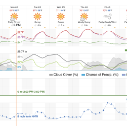
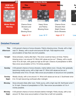
I'm planning to be backpacking in the Escalante area Thurs-Sun and it looks like I'm going to be eating a lot of sand.
Don't like ads? Become a BCP Supporting Member and kiss them all goodbye. Click here for more info.


