Navigation
Install the app
How to install the app on iOS
Follow along with the video below to see how to install our site as a web app on your home screen.
Note: This feature may not be available in some browsers.
More options
Style variation
You are using an out of date browser. It may not display this or other websites correctly.
You should upgrade or use an alternative browser.
You should upgrade or use an alternative browser.
Uintas Mega Map
- Thread starter Nick
- Start date
- Joined
- Aug 9, 2007
- Messages
- 12,959
Does Topo use the USGS maps?
Yes.
This whole thread is hilarious. Both of you were arguing so politely up till this point. haha!Asshole.
In my defense, my copy quit working about 3 years ago.
And I still like my PSDs. It's still a buggy and crappy UI.
- Joined
- Aug 9, 2007
- Messages
- 12,959
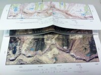
Okay, despite MyTopo's miserable user interface, I found something I really like about it. The ability to make a map and then make an identical map but using satellite images instead. So for my trip this weekend, I have a topo of the East Fork Bear River drainage printed on 11x17 and then on the other side of the same sheet, I have the satellite image. Not too shabby...


So as you all probably know, NatGeo's Topo! data was transitioned to AllTrails.com in early 2012.
(Article http://techcrunch.com/2012/01/17/al...aphic-launches-redesigned-co-branded-website/)
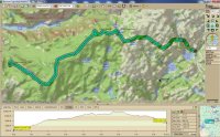
How has this affected your opinions on topo software? Have any of you signed up for a pro account yet? I'm thinking about doing it. $50/year seems like a great deal, esp. given all the paper maps I end up buying. Anyone know if it's even worth/possible buying the old NatGeo desktop software? thanks!
John Mckean
Member
- Joined
- Jun 9, 2013
- Messages
- 37
I liked the back and forth about the maps... I learned something
Don't like ads? Become a BCP Supporting Member and kiss them all goodbye. Click here for more info.

