Uintas Conditions 2023

Upgrayedd

Member
Joined
Apr 12, 2014
Messages
190
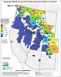
Given the record snowfall we've had this year, any guesses on when the Uintas will be good to go? Normally I like to backpack up there in late May to mid June while there is still some snow out to beat the bugs and the hordes of people. Really curious to see how things play out this year.
 
Last edited:
I drove past them today on 80 and wow, there's still a gigantic amount of snow even down low near the freeway.

anyway I'm super interested in this as well -- I've never really tried to hit the spring sweet spot in the Uintas but I've always wanted to.
 
I'm not good at hitting the magic Uintas window when a bunch of the snow has melted but before the bugs come out, and it's going to be harder than usual this year. I'd super appreciate any help/advice on this
 
A worthwhile but often frustrating pursuit.

Google says 50d F is a magic number for mosquito-hatching, I think Uinta mosquitoes might be even lower, like a consistent sunny 40-45d... but I have observed two conditions that seemed to be prevalent when doing a June trip and seeing fewer mosquitoes.

I am not a scientist, that disclosure aside, I have had some successful and unsuccessful attempts at just this thing.
Normally when successful it is a very short window when it is still cool outside AND either within a few days of the ice melting off the lake, or ice still covering much of the lake. Luckily as you change elevation you can have different mosquito pressure.

A few years ago we went to Amethyst in mid June and thought we had nailed it. First night there were only a few mosquitoes. Few enough that we slept on the tarp en plein air. The next day it warmed up and was sunny. As the sun was going down the frogs burst into song and the mosquitoes rose in dark clouds from anywhere remotely wet. Quite the sight.
We were unable to enjoy dinner or even kill all of the mosquitoes buzzing in the net that night.

Another year there were plenty of mosquitoes in the morning at the Crystal Lakes TH, but up by Island and Ramona there was still some snow along the far shore and it was cooler, and we did not see any for two days. I think there might have been parts of the day 45-50d, but the rest was partly cloudy and chilly.

I am resigned to this year being full of mosquito clouds from snowmelt into July and even early August.
super interesting material, thanks!!
 
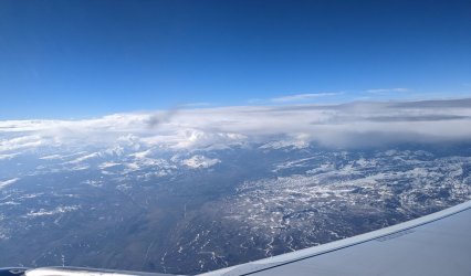
Lots of snow still. Got a fantastic flyby along the north slope on my flight from SLC to MSP today.

PXL_20230516_145628854.jpg
Looking south along the northern extent of Mirror Lake Highway.

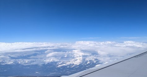
PXL_20230516_145858322.jpg
Some drainages a little farther east. I think Red Castle area is farthest right, but I'm not sure.
 
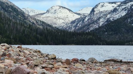
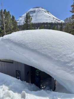
There is still plenty of snow left to melt in the Uintas.

This is a photo from my buddy, from Smith Morehouse looking south.
No active plowing yet on the MLH, the snow starts only a little ways after Soapstone. Funny thing, because of the snow being packed down by the snowmobiles there is a good section where the only snow left is on the road for a little ways.


20230527_194021.jpg
 
I wonder when it will be possible to get to Cataract Gorge -- it should be epic with high flows
 
I wonder when it will be possible to get to Cataract Gorge -- it should be epic with high flows

I am sure you could hike over there now and just posthole a little or a lot :)
As long as snow is melting up higher, it will be running nice and high.
 
I have a trip planned for June18 to do the whole UHT. I'm hoping highway150 is open by then. I have experience with snow travel (summited Rainier, Whitney, Elbert and Shasta with snow). Does anyone know or have resources for avalanche conditions? Are the Uintas known for them? Anyone hike in there recently and seen how much snow there is left? I called a ranger station and she told me 4-8ft in the mountains. She told me to push my trip off but my wife is having our first kid in July and I just can't pull anything later.
 
She told me to push my trip off but my wife is having our first kid in July and I just can't pull anything later.
No info on the snow conditions, but don't make the mistake I did. I was pretty deep in GTNP when my second decided to show up early. Thank goodness: 1) it wasn't the first one; 2) it was an "easy" (in a relative sense) birth; and 3) my wife is amazing. :lol:

Best of luck on the trip and the new addition!
 
Yeah her due date is July28 but a month early isn't unheard of so I really hope it doesn't happen. I won't even have service to catch it on a zoom call lol.
 
I have a trip planned for June18 to do the whole UHT. I'm hoping highway150 is open by then. I have experience with snow travel (summited Rainier, Whitney, Elbert and Shasta with snow). Does anyone know or have resources for avalanche conditions? Are the Uintas known for them? Anyone hike in there recently and seen how much snow there is left? I called a ranger station and she told me 4-8ft in the mountains. She told me to push my trip off but my wife is having our first kid in July and I just can't pull anything later.
Yeah UAC shuts down forecasts well before summer. But the snowpack up there should hopefully be nicely consolidated by then, meaning that the remaining possibilities would be glide avalanches, cornice falls, and surface sluffs. The latter should be reasonably easy to manage by avoiding dangerous slopes when the snowpack warms up. Cornices are pretty obvious. Not sure about glide avalanches in the Uintas. I like to do spring/summer snow climbs in the Wasatch once things consolidate and feel like I manage the risk pretty well by going early in the morning, by avoiding being up there when it's really warm (and especially after 3+ very warm days) and of course avoiding being on or below cornices. I have run this past people who know more and they seem to agree that it's a reasonable strategy. Things are a lot less scary once the big slab avalanches have stopped. But again, I've not done real snow travel in the Uintas, and I'm not an expert, and also this year is probably quite different from any year in recent memory.
 
I should add that I've backed off of plenty of snow climbs after getting wigged by conditions, for example a 35 degree slope softening up too rapidly. But also, I trust my intuition, which I built up due to my snow climbing buddy for many years being a fairly paranoid fellow who had climbed a number of 6/7/8000m peaks.
 
I can't find any posts about people doing the trail yet so I am a little nervous. I know that the 150 is still closed but the 35 from Francis to Hanna is open now. Looking at my map there are trails about 8miles from the end (150) you can shoot south and pop out at the 35. I was thinking my group could leave a car near the 35 and get to hit almost all of the trail.

I'm putting together a plan b in Colorado if I'm not confident with the conditions for UHT. Hopefully within 7-10 days I'll be able to find some info.
You'd be the very first. I get that you have snow travel experience, but ask yourself whether you really actually want to do 100 miles on snow... all day every day for two weeks or whatever. An alpine start is fine for a few days, but you will be getting up at 2am every day and probably making camp at noon once things get too postholey. Or bring skis.

As an aside, I'm not sure the plan for Colorado would be any better unless it's at substantially lower elevation.
 
That would be an epic adventure you wouldn't forget, but I don't think you would have very much fun and I don't think it would be very safe. With a kid coming on the way I would honestly advise against doing it. Then again I am a fairly cautious person. I believe the San Juans in Colorado melt out pretty early, you might want to look into conditions for that area and put together a good route.
 
Trying to think about going up Deadhorse with the amount of snow still up there is hair raising. As others have said, trying to grind 100 miles in snow would be rough and any meadow that's melted out would be just an incredible amount of standing water. Even if it's doable it would be miserable unless you specifically had this as your objective from the start.

We did it last year from July 1-9 in a very, very low snow year and there were still a few patches of snow and lots of water on the ground.
 

Don't like ads? Become a BCP Supporting Member and kiss them all goodbye. Click here for more info.

Back
Top