- Joined
- Jan 4, 2015
- Messages
- 2,908
Since everyone else is sharing TRs from last summer, figure I might as well jump in as well.
Several years ago, I did a short-but-sweet weekend backpacking trip in the Tushar Mountains of south-central Utah. As it turns out though, it's impossible to do a trip in the Tushars without staring enviously at those two angular white-tipped giants in the northern part of the range - Belknap and Baldy. I vowed to return someday and summit those iconic peaks. And yet, for several years, it just didn't happen for one reason or another. Until Covid scuttled my 2020 plans, that is.
As May turned to June, and it became clear that the my planned PCT SOBO was going to turn into a NOGO, I started scrambling for other options. I planned a socially distant road trip - sleeping in my car, staying in wild places, dropping into town occasionally just to pick up groceries and leave again. The trip revolved around a half-dozen backpacking trips, one of which was a reunion tour of the Tushars.
Day 1:
I parked near Puffer Lake, following a surprisingly-extant trail up toward Mt Holly. I caught a glimpse of the ski area here and there, but considering that it's smack-dab in the middle of the range, I could see it only rarely, and its presence was never objectionable (unlike the battleship atop Hidden Peak in the Wasatch, for example).
At the foot of Mt Holly, I left the trail and climbed steeply up the grass-and-talus slopes to the top of Baldy. That's a one-sentence description and makes it sound easy, but I assure you it was not. Two months of living in lockdown at 600 feet above sea level, and more than a little good home cookin' had conspired to turn me into a corpulent mess. I did a good bit of huffing and puffing, and stopping to catch my breath, but eventually I topped out on Holly, just barely shy of 12,000 feet.

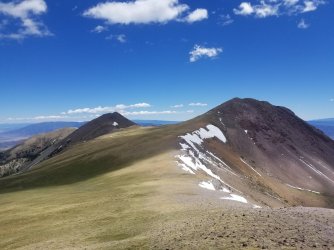
While Holly wasn't quite 12,000', it was close enough to garner an honorable mention. The goal on this trip was to climb all five of the Tushars Twelvers - Delano, Baldy, and Belknap, plus two the unnamed bumps on the ridge east of Delano. So I headed along the ridge toward Delano, driving a large herd of mountain goats northward. Eventually they tired of being chased by the lumbering red-faced man, and the darted down some crumbly cliffs. I could only watch in amazement.

There was one thin/steep spot on the ridge heading toward Delano, but as I neared it, I found a pretty decent trail - mostly goat-created, and perhaps a few intrepid humans over the years. Once I passed that spot, the ridge broadened again, and it was a pretty easy stroll up to the gently rounded summit of Delano. From Delano, I could see my twin objectives to the north - Baldy and Belknap.
But first - a diversion. I headed east along the Delano-Brigham ridgeline to tag the two unnamed peaks. I'd summited them both before, on my previous trip, but if I was gonna try and hit all the twelvers in a single trip, then darn it, I was gonna hit them all. On the way there, I was reminded again just how annoying bumpy ridgelines are, when you're up in the thin air. The peaks were only hard inasmuch as climbing at 12,000 feet is hard when your body isn't really even acclimated to 1,200 feet. But I did them - rather slowly, I might add - and of course, the views were excellent all around.

I scampered back to Delano, tagging it again as I continued northward along the main Tushar crest. A road soon joined the crest, which was a bit of a muddy walk. Plenty of snow still adorned the landscape, and I did contend with a bit of it. I had to drop a couple hundred feet off the ridge at one point in order to find some liquid water to refill my bottles. I made camp at almost exactly 11,000', near where the road leaves the ridge and descends out of the mountains. It was a pleasant evening, and though I was camped right next to the road, there was zero traffic. I'd picked the sweet spot where there's not enough snow for snowmobiles, and too much snow for ATVs. Score.


Day 2
This was gonna be the tough one. I began by walking an undulating ridgeline, now transitionin to that distinctive white rock in the northern part of the range. I kept an eye out for bristlecone pines, as this really looked like ideal habitat for them. I found a few questionable specimens, but I don't know my botany well enough to be sure. At any rate, the area was beautiful, with the white rock glimmering in the early morning sunshine. Eventually, I cut west, on a goat /use trail beaten into the talus slopes. There was one spot that had slid out and was pretty unpleasant to navigate, but other than that it was fine. Finally, having finished contouring, I arrived at the base of Belknap.

From a distance, Belknap looks pretty imposing, but there was another well-established use trail beaten into the talus. I encountered a little snow on the way up, but it wasn't too bad, and before I knew it, I was standing on top of the Tushars' silver medalist.
While the view from Belknap was great, I almost immediately started worrying about Baldy. From this vantage point, it looked snow-locked, and pretty dang vertical. I strode down the backside of Belknap with a purpose, trying to catch baldy before the bright sunshine turned it into a slushy mess. The long ridgeline between Belknap and Baldy was absolutely spectacular. A few trees dotted the landscape here and there, and the snow complemented the yellow and white rock well. Below, Blue Lake was doing its blue thing. It was amazing.


I arrived at the base of Baldy, and it didn't look any easier than it did from afar. I just about bailed right there, but resolved to at least try the climb, and bail at the first sight of trouble. I put my microspikes on and started the snow climb. It was unrelentingly steep, and took far longer than the climb of Belknap, but it just kept going, and I always felt I'd be able to safely descend the way I came, if I had to. I came to one crux, a steep snow pitch, and after spending a few minutes chopping two steps with my trekking pole baskets, I was up, over the snow, onto solid rock again. The rest of the way to the summit was an uneventful boulder-hop. Nobody had signed the summit register yet that year. That's not to say that nobody had summited, just that nobody had summited after the register had melted out. Still, it was an amazing feeling to be standing on one of the pinnacles of the Tushars, in a barren, snowy, beautiful landscape. And for a few minutes, I did not think about the pandemic.


Continuing west, I began a long, slow descent out of the high country. After dropping a little bit, to the edge of treeline, I found them - elusive bristlecone pines. They weren't very big, even by bristlecone standards, but there they were. They'd been here, silently keeping watch, as the Spanish Flu in 1920 raged in 1920. They'd been here when the Black Death hit the other side of the globe in the 14th century. And they'd even been here for the first round of that same sickness - the plague of Justinian in 541. There was something timeless about these shrimpy little trees. I grinned at them. I didn't take a picture. It seemed disrespectful.
The ridgeline seemed to stretch on forever, and eventually I dropped solidly below treeline, into a large burn area. As burn areas go, it wasn't horrible - while I did have to clamber over several piles of giant pick-up sticks, I was high up enough that the forest wasn't particularly dense pre-fire. Soon enough, I hit a trail - my first of the day, and crossed the South Fork of North Creek. Between the large amount of vertical, the stressing about Baldy, a ton of off-trail travel, and an annoying burn area, I was pretty tuckered, and made a pretty crappy camp about a thousand feet above the creek where things started to flatten out. I had planned on hitting Shelly Baldy, but that dream died a quick death. I just didn't have much energy left.

Day 3
Predictably, I didn't sleep super well in my crappy, angled campsite, and was on the trail early. While the trail certainly had its fair share of post-winter blowdowns, it was surprisingly okay. After a couple of easy miles, I hit Big John Flat, where I saw the first evidence of humans since I'd begun the trip. There were a couple of campers parked here and there, but it was fairly quiet. After a brief roadwalk, I picked up the Skyline NRT, which bobbed and weaved near treeline at the base of the Delano-Holly ridge- where I'd been two days prior. After a final above-treeline flourish, I turned off the Skyline Trail down a side trail back to Puffer Lake. All of these were pretty easy miles, but a couple of hard days and the lack of oxygen meant that I didn't feel super great.


I finished at my car, cooked some food, and did some laundry in my cooler. I looked back at the mountains. Time well spent. I was happy to have climbed all the Tushars Twelvers, and it's given me an interesting project - to summit all of the twelvers in Utah outside of the Uintas. I've been furiously caltopo-ing the Deep Creeks and La Sals. Given how it took to check off the Tushars, I'll probably be collecting social security by time I complete the project. But if those trips are half as amazing as this one was, it'll all be worth it.

Several years ago, I did a short-but-sweet weekend backpacking trip in the Tushar Mountains of south-central Utah. As it turns out though, it's impossible to do a trip in the Tushars without staring enviously at those two angular white-tipped giants in the northern part of the range - Belknap and Baldy. I vowed to return someday and summit those iconic peaks. And yet, for several years, it just didn't happen for one reason or another. Until Covid scuttled my 2020 plans, that is.
As May turned to June, and it became clear that the my planned PCT SOBO was going to turn into a NOGO, I started scrambling for other options. I planned a socially distant road trip - sleeping in my car, staying in wild places, dropping into town occasionally just to pick up groceries and leave again. The trip revolved around a half-dozen backpacking trips, one of which was a reunion tour of the Tushars.
Day 1:
I parked near Puffer Lake, following a surprisingly-extant trail up toward Mt Holly. I caught a glimpse of the ski area here and there, but considering that it's smack-dab in the middle of the range, I could see it only rarely, and its presence was never objectionable (unlike the battleship atop Hidden Peak in the Wasatch, for example).
At the foot of Mt Holly, I left the trail and climbed steeply up the grass-and-talus slopes to the top of Baldy. That's a one-sentence description and makes it sound easy, but I assure you it was not. Two months of living in lockdown at 600 feet above sea level, and more than a little good home cookin' had conspired to turn me into a corpulent mess. I did a good bit of huffing and puffing, and stopping to catch my breath, but eventually I topped out on Holly, just barely shy of 12,000 feet.
While Holly wasn't quite 12,000', it was close enough to garner an honorable mention. The goal on this trip was to climb all five of the Tushars Twelvers - Delano, Baldy, and Belknap, plus two the unnamed bumps on the ridge east of Delano. So I headed along the ridge toward Delano, driving a large herd of mountain goats northward. Eventually they tired of being chased by the lumbering red-faced man, and the darted down some crumbly cliffs. I could only watch in amazement.
There was one thin/steep spot on the ridge heading toward Delano, but as I neared it, I found a pretty decent trail - mostly goat-created, and perhaps a few intrepid humans over the years. Once I passed that spot, the ridge broadened again, and it was a pretty easy stroll up to the gently rounded summit of Delano. From Delano, I could see my twin objectives to the north - Baldy and Belknap.
But first - a diversion. I headed east along the Delano-Brigham ridgeline to tag the two unnamed peaks. I'd summited them both before, on my previous trip, but if I was gonna try and hit all the twelvers in a single trip, then darn it, I was gonna hit them all. On the way there, I was reminded again just how annoying bumpy ridgelines are, when you're up in the thin air. The peaks were only hard inasmuch as climbing at 12,000 feet is hard when your body isn't really even acclimated to 1,200 feet. But I did them - rather slowly, I might add - and of course, the views were excellent all around.
I scampered back to Delano, tagging it again as I continued northward along the main Tushar crest. A road soon joined the crest, which was a bit of a muddy walk. Plenty of snow still adorned the landscape, and I did contend with a bit of it. I had to drop a couple hundred feet off the ridge at one point in order to find some liquid water to refill my bottles. I made camp at almost exactly 11,000', near where the road leaves the ridge and descends out of the mountains. It was a pleasant evening, and though I was camped right next to the road, there was zero traffic. I'd picked the sweet spot where there's not enough snow for snowmobiles, and too much snow for ATVs. Score.
Day 2
This was gonna be the tough one. I began by walking an undulating ridgeline, now transitionin to that distinctive white rock in the northern part of the range. I kept an eye out for bristlecone pines, as this really looked like ideal habitat for them. I found a few questionable specimens, but I don't know my botany well enough to be sure. At any rate, the area was beautiful, with the white rock glimmering in the early morning sunshine. Eventually, I cut west, on a goat /use trail beaten into the talus slopes. There was one spot that had slid out and was pretty unpleasant to navigate, but other than that it was fine. Finally, having finished contouring, I arrived at the base of Belknap.
From a distance, Belknap looks pretty imposing, but there was another well-established use trail beaten into the talus. I encountered a little snow on the way up, but it wasn't too bad, and before I knew it, I was standing on top of the Tushars' silver medalist.
While the view from Belknap was great, I almost immediately started worrying about Baldy. From this vantage point, it looked snow-locked, and pretty dang vertical. I strode down the backside of Belknap with a purpose, trying to catch baldy before the bright sunshine turned it into a slushy mess. The long ridgeline between Belknap and Baldy was absolutely spectacular. A few trees dotted the landscape here and there, and the snow complemented the yellow and white rock well. Below, Blue Lake was doing its blue thing. It was amazing.
I arrived at the base of Baldy, and it didn't look any easier than it did from afar. I just about bailed right there, but resolved to at least try the climb, and bail at the first sight of trouble. I put my microspikes on and started the snow climb. It was unrelentingly steep, and took far longer than the climb of Belknap, but it just kept going, and I always felt I'd be able to safely descend the way I came, if I had to. I came to one crux, a steep snow pitch, and after spending a few minutes chopping two steps with my trekking pole baskets, I was up, over the snow, onto solid rock again. The rest of the way to the summit was an uneventful boulder-hop. Nobody had signed the summit register yet that year. That's not to say that nobody had summited, just that nobody had summited after the register had melted out. Still, it was an amazing feeling to be standing on one of the pinnacles of the Tushars, in a barren, snowy, beautiful landscape. And for a few minutes, I did not think about the pandemic.
Continuing west, I began a long, slow descent out of the high country. After dropping a little bit, to the edge of treeline, I found them - elusive bristlecone pines. They weren't very big, even by bristlecone standards, but there they were. They'd been here, silently keeping watch, as the Spanish Flu in 1920 raged in 1920. They'd been here when the Black Death hit the other side of the globe in the 14th century. And they'd even been here for the first round of that same sickness - the plague of Justinian in 541. There was something timeless about these shrimpy little trees. I grinned at them. I didn't take a picture. It seemed disrespectful.
The ridgeline seemed to stretch on forever, and eventually I dropped solidly below treeline, into a large burn area. As burn areas go, it wasn't horrible - while I did have to clamber over several piles of giant pick-up sticks, I was high up enough that the forest wasn't particularly dense pre-fire. Soon enough, I hit a trail - my first of the day, and crossed the South Fork of North Creek. Between the large amount of vertical, the stressing about Baldy, a ton of off-trail travel, and an annoying burn area, I was pretty tuckered, and made a pretty crappy camp about a thousand feet above the creek where things started to flatten out. I had planned on hitting Shelly Baldy, but that dream died a quick death. I just didn't have much energy left.
Day 3
Predictably, I didn't sleep super well in my crappy, angled campsite, and was on the trail early. While the trail certainly had its fair share of post-winter blowdowns, it was surprisingly okay. After a couple of easy miles, I hit Big John Flat, where I saw the first evidence of humans since I'd begun the trip. There were a couple of campers parked here and there, but it was fairly quiet. After a brief roadwalk, I picked up the Skyline NRT, which bobbed and weaved near treeline at the base of the Delano-Holly ridge- where I'd been two days prior. After a final above-treeline flourish, I turned off the Skyline Trail down a side trail back to Puffer Lake. All of these were pretty easy miles, but a couple of hard days and the lack of oxygen meant that I didn't feel super great.
I finished at my car, cooked some food, and did some laundry in my cooler. I looked back at the mountains. Time well spent. I was happy to have climbed all the Tushars Twelvers, and it's given me an interesting project - to summit all of the twelvers in Utah outside of the Uintas. I've been furiously caltopo-ing the Deep Creeks and La Sals. Given how it took to check off the Tushars, I'll probably be collecting social security by time I complete the project. But if those trips are half as amazing as this one was, it'll all be worth it.
Attachments
Last edited:
