triangular float trips

regehr

Member
Joined
Mar 28, 2012
Messages
2,267
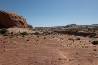
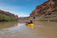
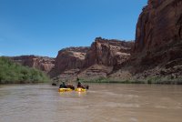
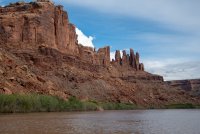
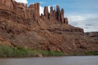
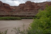
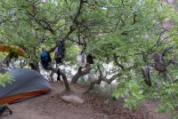
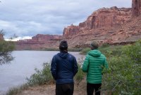
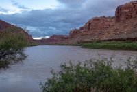
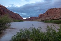
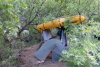
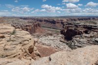
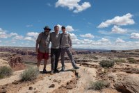
So I got a little bit obsessed with finding float trips that don't require a car/bike shuttle. Over the last three days some buds and I hiked down Keg Spring Canyon starting at the Andy Moore trail, floated the Green around Bowknot Bend, then exited Twomile Canyon and cross-country back to the vehicle. This worked. The Green is running fast and full and we did ~18 river miles in about 5 hours of paddling time. Almost zero bugs at camp, for whatever reason. Saw some geese + goslings on the river. Had an hour of rain at breakfast time yesterday and then 2+ hours of paddling in the rain, but otherwise the unsettled weather was not a problem. I was worried about getting nailed by a thunderstorm while floating but this failed to happen. Also worried about the clay roads out there getting slicked up but that didn't happen either. We saw three other groups on the Green and briefly chatted with two of them.

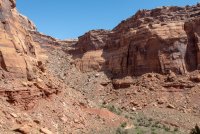
Keg Spring Canyon sucked, with multiple long sections of difficult bushwacking. Not so fun with big packs. The Twomile Canyon exit was super cool, that's a great trail and it receives a lot more foot traffic than I'd have guessed, the trail is kinda national park level. The cross-country part back to near the Andy Moore Trail would have been tough to nail without GPS, those many upper forks of Keg Springs are really confusing.
 
Bugs typically don't become an issue until the river level drops again and leaves standing water behind.
good to know. we already had both cedar gnats and mosquitoes in Capitol Reef two weeks ago so I was expecting things to be worse in a lower, wetter area.
 
A few pics.

Packing up near the head of one of the forks of Keg Spring Canyon
IMG_1693.jpg


Looking down canyon from near the top of the Andy Moore Trail. Keg Spring Canyon is briefly an easy walk then turns into a brush thrash.
IMG_1700.jpg

IMG_1704.jpg

IMG_1708.jpg

I didn't take any more pics this day, but the camping near the mouth of Keg Spring C is quite nice, and there was sporadic water all the way from the top to the bottom of this canyon.

Next morning it rained for hours so again I didn't take pics, here we're stopped for snacks somewhere near Hey Joe C.
IMG_1716.jpg
IMG_1718.jpg
IMG_1719.jpg
IMG_1721.jpg

Now we're going around Bowknot Bend I think.
IMG_1727.jpg
IMG_1738.jpg
IMG_1740.jpg

The river was fairly high (around 10,000 CFS) and there were near zero sand/mud bars but we stopped for a break at this one, near the end of the long straightaway at the back of Bowknot Bend.

IMG_1751.jpg
IMG_1754.jpg
IMG_1761.jpg
IMG_1763.jpg

And then we ran across a really nice campsite a little ways upstream of Twomile Canyon. Someone had even loaded it up with firewood, but we hadn't brought a fire pan and decided to be good citizens.
IMG_1776.jpg

IMG_1779.jpg

IMG_1795.jpg

IMG_1798.jpg

I didn't get a good picture of them but these were left by a mating pair of geese and a couple goslings.
IMG_1820.jpg

IMG_1829.jpg

Twomile Canyon, the trail goes up the left-hand talus slope:
IMG_1831.jpg

Partway up
IMG_1833.jpg

IMG_1834.jpg

Kinda dying at this point with the heavy packs
IMG_1835.jpg

IMG_1836.jpg

IMG_1841.jpg

IMG_1845.jpg

Some weather was moving in from many directions so we hoofed it across the many forks of Keg Spring C and got out of there.
IMG_1847.jpg
 

Attachments

  • IMG_1696.jpg
    IMG_1696.jpg
    617.2 KB · Views: 15
  • IMG_1736.jpg
    IMG_1736.jpg
    555.5 KB · Views: 13
  • IMG_1730.jpg
    IMG_1730.jpg
    533.2 KB · Views: 12
  • IMG_1764.jpg
    IMG_1764.jpg
    601 KB · Views: 12
  • IMG_1766.jpg
    IMG_1766.jpg
    717.4 KB · Views: 13
  • IMG_1786.jpg
    IMG_1786.jpg
    757.3 KB · Views: 12
  • IMG_1792.jpg
    IMG_1792.jpg
    1 MB · Views: 10
  • IMG_1796.jpg
    IMG_1796.jpg
    631.3 KB · Views: 12
  • IMG_1797.jpg
    IMG_1797.jpg
    644.9 KB · Views: 13
  • IMG_1802.jpg
    IMG_1802.jpg
    644.4 KB · Views: 11
  • IMG_1811.jpg
    IMG_1811.jpg
    953 KB · Views: 11
  • IMG_1830.jpg
    IMG_1830.jpg
    859 KB · Views: 16
  • IMG_1842.jpg
    IMG_1842.jpg
    776.4 KB · Views: 11
  • IMG_1844.jpg
    IMG_1844.jpg
    660.4 KB · Views: 14
Did you spot the bottom of the Chuchuru sheep trail? I've been to the top but can't figure out where it bottoms out.
 
Did you spot the bottom of the Chuchuru sheep trail? I've been to the top but can't figure out where it bottoms out.
Yeah, it's a bit upstream of that pump house. Or at least, we saw what looked like the only plausible route out of that part of the canyon there. I sort of wanted to explore it but we were making poor time due to bushwacking and gave it a miss. I can't do it this week but sometime before if it gets hot I'd be happy to do a day trip to do Chuchuru/Buck Canyon as a quick day hike.

It looked to me like the system of ledges at 38°36'1.53"N 110° 6'10.98"W has the route, but again we didn't check this out
 
Last edited:
yeah, ok, this corroborates with Kelsey who says the trail lands about 100 meters upcanyon from the pump house, so I think that's definitely it. also in GE you can see what looks like a foot trail in between the upper and lower parts of the Chuchuru trail, for example at 38°36'2.61"N 110° 6'16.57"W
 
Ahh yeah, you can see a rock wall (or some sort of construction) at 38° 36.014'N 110° 6.187'W in Google Earth. Thanks!
 
Back
Top