zionsky
Member
- Joined
- Dec 23, 2018
- Messages
- 778
When I was a kid, I believe it was one of my aunt's who always said “you get what you get and you don't fuss a bit”. So when I planned my trip to Maine six months ago, I knew anything was possible with the weather .
I had been to Baxter in the fall of 2011 and the weather then prevented my attempted summit of mount katahdin. I had fun in other parts of the park but left somewhat disappointed as I did not accomplish my main goal.
Fast forward eight years, 15 pounds heavier, and two waist sizes higher. This trip would have a little of everything; sun, rain, pain, wind, fog, moose, and a flat tire.
The first two days were a warm up for the big climb. Day 1 was an afternoon in gulf hagas- a gorge located in the mountains of northern Maine about an hour south of katahdin. It is also called the Grand Canyon of Maine. It has many trails and is part of the AT corridor. The Pleasant River flows through the area creating a beautiful vertical walled slate gorge filled with several waterfalls. Be aware that they do charge $15 per person if you are from out of state to access the area and the drive in from any direction is along dirt roads. For the most part, they are well maintained. We parked at the lower parking area and took the rim trail up. The trail has a few steep spots but is, for the most part, moderate. The fun part comes less than .2 miles from the start where you have to ford the river. It was cold and running about mid-calf deep.
About a mile up was screw auger falls, this is the upper falls
this is the lower falls.

A little farther up we came to "the jaws".
About 3 miles up were buttermilk falls.
Not wanting to finish the hike in the dark, we cut across to the pleasant river tote trail and took it back to the car passing several small ponds .
Fording the river again felt awesome on the feet after 7 miles of hiking.
All in all, a good start to the trip
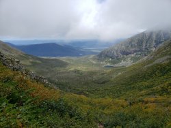
Day 2 was to be interesting. I was not successful in obtaining a permit for the roaring brook parking lot (the most direct access to katahdin) so we decided to explore other parts of the park. As it turned out, it was to rain most of the day so it would have been useless (and dangerous) to even try. I wanted to get some elevation in before the big climb so we decided on sentinel mountain (900' gain). The shortest route is about 3 miles (one way) from the kidney pond TH but we wanted to explore some of the many ponds in the area and hopefully see some moose. So we took a myriad of trails beginning at the katahdin stream TH and winding around grassy pond and daicey pond with the goal of eventually arriving at kidney pond. It was a gorgeous hike but the clouds and light rain provided minimal views of the surrounding mountains.


Somewhere along the way, my trusted navigator who, never gets lost, got us on the wrong trail. About 30 minutes later, we realized this and decided we were now closer to the car than kidney pond so we decided we should just go back , grab the car, and start from kidney pond. Three hours, six miles to make a circle. The one good thing to come from our misdirection was to come upon a female moose eating in the marsh along the “wrong” trail.
We moved the car to kidney pond, and made the 6 mile hike in about 4 hours. The summit has 360 views but clouds and rain limited the wow factor essentially looking north towards katahdin, which now was completely covered in clouds .

We got back to the car as the rain was getting heavier. As I went get in the car, I noticed one of the front tires was COMPLETELY flat. We put the donut tire on in the pouring rain
and left the park. I was a little nervous as all the roads in the park are dirt and we had about 20 minutes of driving to get back on asphalt. I ended up taking the rental car to Bangor (90 minute drive) to get a replacement. We got back to the motel that evening. What a day!
Day 3 was the main event – Mount Katadhin – 4000' vertical gain and 10-12 miles round trip Weather was iffy for views (partly cloudy) but no rain. I had been fortunate enough to get a permit for roaring brook TH for that day (weekends fill up fast in the fall) We got there about 6:15 am so as not to lose our spot (they give away your space if you are not there by 7:00 a.m.) There was a line of about 15 cars waiting to take spaces from the no shows. We made it to the ranger check -in about 7:15. He told us it was about 40 degrees on the summit, mostly cloudy, and steady 30-40 mph winds. I had wanted to go up the helon -taylor trail to the knife edge to the summit and back down the saddle trail. He suggested taking the saddle up to the summit and then assess the route down based on conditions. We took his advice. The first 3 miles up to chimney pond are not steep but steadily gain elevation. The trail is mostly rock, a little dirt, a few planks and wooden walkways.


A little bit of early color.

From chimney pond, things get more serious. The first .5 miles get steeper and then you hit the boulder slide – a half mile of semi-vertical hiking/climbing/bouldering.

The lungs and the calves were burning by the time I got to the top of the saddle. Upon cresting the saddle, I felt the full force of the cold air and gusty wind. We donned our fleece, gloves, and toboggans and proceeded in to the foggy tundra that would take us to the summit.

The last mile to the summit was not too steep but the wind, fatigue, and crumbly rock trail made it a slow slog. The wind nearly knocked me over a couples of times. We made it to the summit around 10:45 a.m.

I desperately wanted to descend via the knife edge but the clouds and wind would not let up. Here's about all of the knife edge we could see through the fog

After a little bit of consternation, I begrudingly headed back down the way I'd came. Unfortunately the steep, rocky descent was just about as difficult on the old legs as they way up.

I kept looking over my shoulder on the way down but the top of the mountain would only show itself for a few seconds before ducking behind the clouds.
We arrived back at the TH about 2:00. Even with the clouds, it was a great, long weekend in Maine.
I had been to Baxter in the fall of 2011 and the weather then prevented my attempted summit of mount katahdin. I had fun in other parts of the park but left somewhat disappointed as I did not accomplish my main goal.
Fast forward eight years, 15 pounds heavier, and two waist sizes higher. This trip would have a little of everything; sun, rain, pain, wind, fog, moose, and a flat tire.
The first two days were a warm up for the big climb. Day 1 was an afternoon in gulf hagas- a gorge located in the mountains of northern Maine about an hour south of katahdin. It is also called the Grand Canyon of Maine. It has many trails and is part of the AT corridor. The Pleasant River flows through the area creating a beautiful vertical walled slate gorge filled with several waterfalls. Be aware that they do charge $15 per person if you are from out of state to access the area and the drive in from any direction is along dirt roads. For the most part, they are well maintained. We parked at the lower parking area and took the rim trail up. The trail has a few steep spots but is, for the most part, moderate. The fun part comes less than .2 miles from the start where you have to ford the river. It was cold and running about mid-calf deep.
About a mile up was screw auger falls, this is the upper falls
this is the lower falls.
A little farther up we came to "the jaws".
About 3 miles up were buttermilk falls.
Not wanting to finish the hike in the dark, we cut across to the pleasant river tote trail and took it back to the car passing several small ponds .
Fording the river again felt awesome on the feet after 7 miles of hiking.
All in all, a good start to the trip
Day 2 was to be interesting. I was not successful in obtaining a permit for the roaring brook parking lot (the most direct access to katahdin) so we decided to explore other parts of the park. As it turned out, it was to rain most of the day so it would have been useless (and dangerous) to even try. I wanted to get some elevation in before the big climb so we decided on sentinel mountain (900' gain). The shortest route is about 3 miles (one way) from the kidney pond TH but we wanted to explore some of the many ponds in the area and hopefully see some moose. So we took a myriad of trails beginning at the katahdin stream TH and winding around grassy pond and daicey pond with the goal of eventually arriving at kidney pond. It was a gorgeous hike but the clouds and light rain provided minimal views of the surrounding mountains.
Somewhere along the way, my trusted navigator who, never gets lost, got us on the wrong trail. About 30 minutes later, we realized this and decided we were now closer to the car than kidney pond so we decided we should just go back , grab the car, and start from kidney pond. Three hours, six miles to make a circle. The one good thing to come from our misdirection was to come upon a female moose eating in the marsh along the “wrong” trail.
We moved the car to kidney pond, and made the 6 mile hike in about 4 hours. The summit has 360 views but clouds and rain limited the wow factor essentially looking north towards katahdin, which now was completely covered in clouds .
We got back to the car as the rain was getting heavier. As I went get in the car, I noticed one of the front tires was COMPLETELY flat. We put the donut tire on in the pouring rain
and left the park. I was a little nervous as all the roads in the park are dirt and we had about 20 minutes of driving to get back on asphalt. I ended up taking the rental car to Bangor (90 minute drive) to get a replacement. We got back to the motel that evening. What a day!
Day 3 was the main event – Mount Katadhin – 4000' vertical gain and 10-12 miles round trip Weather was iffy for views (partly cloudy) but no rain. I had been fortunate enough to get a permit for roaring brook TH for that day (weekends fill up fast in the fall) We got there about 6:15 am so as not to lose our spot (they give away your space if you are not there by 7:00 a.m.) There was a line of about 15 cars waiting to take spaces from the no shows. We made it to the ranger check -in about 7:15. He told us it was about 40 degrees on the summit, mostly cloudy, and steady 30-40 mph winds. I had wanted to go up the helon -taylor trail to the knife edge to the summit and back down the saddle trail. He suggested taking the saddle up to the summit and then assess the route down based on conditions. We took his advice. The first 3 miles up to chimney pond are not steep but steadily gain elevation. The trail is mostly rock, a little dirt, a few planks and wooden walkways.
A little bit of early color.
From chimney pond, things get more serious. The first .5 miles get steeper and then you hit the boulder slide – a half mile of semi-vertical hiking/climbing/bouldering.
The lungs and the calves were burning by the time I got to the top of the saddle. Upon cresting the saddle, I felt the full force of the cold air and gusty wind. We donned our fleece, gloves, and toboggans and proceeded in to the foggy tundra that would take us to the summit.
The last mile to the summit was not too steep but the wind, fatigue, and crumbly rock trail made it a slow slog. The wind nearly knocked me over a couples of times. We made it to the summit around 10:45 a.m.
I desperately wanted to descend via the knife edge but the clouds and wind would not let up. Here's about all of the knife edge we could see through the fog
After a little bit of consternation, I begrudingly headed back down the way I'd came. Unfortunately the steep, rocky descent was just about as difficult on the old legs as they way up.
I kept looking over my shoulder on the way down but the top of the mountain would only show itself for a few seconds before ducking behind the clouds.
We arrived back at the TH about 2:00. Even with the clouds, it was a great, long weekend in Maine.
") This is home turf for me. I'll be there the second week of October. My profile pic is from last year on the Traveller loop. Nice report.
This is home turf for me. I'll be there the second week of October. My profile pic is from last year on the Traveller loop. Nice report.