Thorofare/Teton Wilderness Trip

TeamJenkins17

“Going to the mountains is going home”.
Joined
May 26, 2019
Messages
112
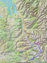
Pretty sure I have next years trip fully planned out. As it goes now my thought is to take the shuttle across Yellowstone Lake and camp at 5E2 the first night, spend the second night at 6C2 and the third night in Yellowstone at 6Y6. From there we’ll travel south stopping at the Thorofare backcountry cabin, past Bridger Lake and the Hawks Rest cabin and camp somewhere along the Yellowstone where we’ll follow it all the way to the south fork and eventually to Marston Pass, from there we’ll traverse the Buffalo plateau to around Perry N Boday Lake, down Bonneville Pass and finish at Brooks Lake. I think this will be a pretty epic trip, but any suggestions or tweaks would be greatly appreciated.
 

Attachments

  • 2A8339E3-81A7-4BAA-9D0E-C92C09B967B0.jpeg
    2A8339E3-81A7-4BAA-9D0E-C92C09B967B0.jpeg
    507.2 KB · Views: 117
This suggestion doesn't come from personal experience, but if it were me and I were that close to Younts Peak on a big route like that, I think I'd go for the summit as part of the 7th day, mileage permitting.

Looks to be an incredible trip!
 
This suggestion doesn't come from personal experience, but if it were me and I were that close to Younts Peak on a big route like that, I think I'd go for the summit as part of the 7th day, mileage permitting.

Looks to be an incredible trip!
Great minds think alike sir, a Younts summit is definitely going on the list, well weather and grizzly permitting. That time of year should have a lot of grizzlies flipping rocks for moths, but I will absolutely shoot for that summit.
 
Do Younts, skip Crescent (you can skirt it to the west). It's just a big talus slog without views any better than what you've been seeing.
 
Do Younts, skip Crescent (you can skirt it to the west). It's just a big talus slog without views any better than what you've been seeing.
Thank you for the advice, definitely going up Younts for sure.
 
Team Jenkins, Now will try to post this reply to your planned trip again and hopefully this time it won't disappear. By your map and everything, it looks like you have a wonderful trip planned. Guess your trip would be in the mid to late summer? But wondering exactly would you do this hike? Again your route looks great and am happy that you are planning to go up the Yellowstone with all the way to Younts peak. Now will give a few tips here and there on this route from my experiences.

Also there are some nice campsites along the Thorofare River, 6T1 and 6T2 also, but Hawks Rest and Bridger Lake is nearby also. Now also a really wild experience is walking along the Yellowstone River from near 6Y6 to the confluence area where the Thorofare River flows into the Yellowstone River. This is offtrail and you never know what one will see along the river. In here often the river banks are covered with all sorts of wildlife tracks. Have come upon the local wolf pack in here at times when doing this. Also this confluence area is one of my more favorite spots back in here. There is a trail from here back towards the main Thorofare Trails. Gorgeous views throughout the area.

I have camped a bunch here at Hawks Rest. Here loved to walk along the banks of the Yellowstone River. There is an excellent spring right near the Forest Service cabin at Hawks Rest which comes out of a metal pipe. Excellent Water. Bridger Lake is only like a half mile walk from the area near the Forest Service cabin. Some excellent campsites on the edge of the trees here which in the summer are heavily used by various horse parties in the summer. In going up the Upper Yellowstone Drainage, it would generally take like 2 to 2 and a half days from here to the head of the South Fork of the Yellowstone. From here at Hawks Rest, it is about 8 up to Castle Creek up the Yellowstone River. Here in 7 to 8 miles is beautiful Castle Creek Meadows. There is a nice campsite with a bearbox for one's food at the far side of the meadows, right off the trail on the left. Have camped here. This campsite again is at the far side of the meadows but before one comes to Castle Creek. Everytime I have been in here, the Castle Creek Meadows area, have seen bear sign along with sometimes various wildlife out in the meadows. From this campsite the Yellowstone River is not far away. There is a good campsite here also near the river. The fires of 1988 reached all the way up here to beyond Castle Creek. From here at castle Creek you go into the forest in going up the Yellowstone. There is only a few campsites it seems in this stretch, to the Woodard Canyon Trail turnoff. Here where the trail turns off for Woodard Canyon, there is a small meadow which have camped in. Okay place at the lower end of the small meadow near the infant Yellowstone River. From here it is near 3 miles or so to the junction of where the North and South Forks of the Yellowstone River come together. This stretch is highly scenic.

Now in this stretch of the Upper Yellowstone River between where the Woodard Canyon turns off and the river junction is a nice old cabin in the trees. On up in this stretch on the trail, one will pass an outfitter camping spot on the left next to the river. Now in the trees on the other side of the trail is an nice standing cabin without a door nearby. one cannot see the cabin from the trail but it is right closeby. Also right before the junction of where the North and South Forks of the Yellowstone River come together, there used to be another old little cabin in here. All is left now is just a few rotting logs on the ground right near where the trail passes by. All of this at least by some years ago when I was last in here.

At the river junction one will be crossing the North Fork of the Yellowstone and going up the South Fork of the Yellowstone which is highly scenic. No problem in crossing the North Fork here. There is an old route viewable and hikeable in places going up the North Fork. The trail - route up the South Fork is a trail but the last I was up it, not the best of trails but doable. At first one goes up thru some trees and a climb, then one will break out into a nice big long spacious meadows that is really scenic with a nice waterfall on the side coming off of the Continental Divide. One can walk up easily to the waterfall. Some beaverdams in this meadow also. Then after this meadow and more trees, one will break out into a small meadow, cross the small South Fork of the Yellowstone and then another climb. After this one breaks out into a beautiful long meadow here in the Upper part of the South Fork of the Yellowstone. There is some camping spots nearby once you breakout into this upper meadow. One is next to a rock out in the open here with great views. Another site is across the small South Fork near a knoll and the trees at the bottom edge of the meadow next to the cliffs, and other areas nearby. Many areas to camp in the area. Then from here the trail goes up thru the huge alpine basin here at the upper end of the South Fork of the Yellowstone with Younts Peak right there.

In here near Younts Peak, be indeed on the lookout for Grizzlies for Younts Peak is a cutworm moth site. I would often see grizzlies here near the peak. Onetime in mid summer in here, I saw 12 Grizzlies in one day on or nearby the peak. Also have had some close encounters with a few grizzlies in the area also. But it all turned out well. Getting up here in the late spring when all of the snow is still melting, with the bears around, is really something else. One will hit a route or old trail up near the pass between Younts Peak and Thorofare Mountain that turns out to be a good trail route down into the head basin of the North Fork of the Yellowstone. All good wild country in here. One could camp, hike, and live back in here for days during high summer in any year. Here also right at the top of Younts Peak is a view that which could be soooo hard to forget. At the top looking over miles and miles and miles of wild country in all directions both near and far. It can be really scenic on a nice super clear, sunny summer day. In the last time I was up on top, i could see the Beartooth Mtns. to the north on the other side of Yellowstone, could barely - barely see the outline of the Bighorn Mtns. beyojd Cody, Wy. to the east, the Wind River Mountains and more to the south, and beyond the Tetons other mtns. beyond in Idaho. One might not be the same afterwards in my opinion.

Then it is a short jaunt over to nearby Marston Pass with then the immense Buffalo Plateau beyond. Crossing the Buffalo Plateau is a more or less easy hike with some short ups and downs along the way with incredible views in all directions. Along the way providing a nice climb is Wall Mountain. Wall Mountain is just an easy walk up. But from on top one is provided with an exceptional view overlooking the South Fork of the Shoshone River Drainage right below in the Washakie Wild. My first hike across here was back in the summer of 1982 and how much this country is as it has always been - wild and nice. And at the end of the Buffalo Plateau is Crescent Mtn. where one can overlook the Wind River Valley to the south. At the south end of the Buffalo Plateau one can go on down to the hear of the South Fork of the Shoshone in one direction. Or over to the head of Cub Creek in another direction. Upper Cub Creek has quite a few nice beautiful mountain meadows in it's upper section. In all of this countries there are many little nooks and crannies all along the way. One could spend days, months, or even years in here and not see it all in my opinion

Hope this helps you out. if you have any questions then feel free to let me know. Wishing You the Best!
 
Last edited:
Team Jenkins, Now will try to post this reply to your planned trip again and hopefully this time it won't disappear. By your map and everything, it looks like you have a wonderful trip planned. Guess your trip would be in the mid to late summer? But wondering exactly would you do this hike? Again your route looks great and am happy that you are planning to go up the Yellowstone with all the way to Younts peak. Now will give a few tips here and there on this route from my experiences.

Also there are some nice campsites along the Thorofare River, 6T1 and 6T2 also, but Hawks Rest and Bridger Lake is nearby also. Now also a really wild experience is walking along the Yellowstone River from near 6Y6 to the confluence area where the Thorofare River flows into the Yellowstone River. This is offtrail and you never know what one will see along the river. In here often the river banks are covered with all sorts of wildlife tracks. Have come upon the local wolf pack in here at times when doing this. Also this confluence area is one of my more favorite spots back in here. There is a trail from here back towards the main Thorofare Trails. Gorgeous views throughout the area.

I have camped a bunch here at Hawks Rest. Here loved to walk along the banks of the Yellowstone River. There is an excellent spring right near the Forest Service cabin at Hawks Rest which comes out of a metal pipe. Excellent Water. Bridger Lake is only like a half mile walk from the area near the Forest Service cabin. Some excellent campsites on the edge of the trees here which in the summer are heavily used by various horse parties in the summer. In going up the Upper Yellowstone Drainage, it would generally take like 2 to 2 and a half days from here to the head of the South Fork of the Yellowstone. From here at Hawks Rest, it is about 8 up to Castle Creek up the Yellowstone River. Here in 7 to 8 miles is beautiful Castle Creek Meadows. There is a nice campsite with a bearbox for one's food at the far side of the meadows, right off the trail on the left. Have camped here. This campsite again is at the far side of the meadows but before one comes to Castle Creek. Everytime I have been in here, the Castle Creek Meadows area, have seen bear sign along with sometimes various wildlife out in the meadows. From this campsite the Yellowstone River is not far away. There is a good campsite here also near the river. The fires of 1988 reached all the way up here to beyond Castle Creek. From here at castle Creek you go into the forest in going up the Yellowstone. There is only a few campsites it seems in this stretch, to the Woodard Canyon Trail turnoff. Here where the trail turns off for Woodard Canyon, there is a small meadow which have camped in. Okay place at the lower end of the small meadow near the infant Yellowstone River. From here it is near 3 miles or so to the junction of where the North and South Forks of the Yellowstone River come together. This stretch is highly scenic.

Now in this stretch of the Upper Yellowstone River between where the Woodard Canyon turns off and the river junction is a nice old cabin in the trees. On up in this stretch on the trail, one will pass an outfitter camping spot on the left next to the river. Now in the trees on the other side of the trail is an nice standing cabin without a door nearby. one cannot see the cabin from the trail but it is right closeby. Also right before the junction of where the North and South Forks of the Yellowstone River come together, there used to be another old little cabin in here. All is left now is just a few rotting logs on the ground right near where the trail passes by. All of this at least by some years ago when I was last in here.

At the river junction one will be crossing the North Fork of the Yellowstone and going up the South Fork of the Yellowstone which is highly scenic. No problem in crossing the North Fork here. There is an old route viewable and hikeable in places going up the North Fork. The trail - route up the South Fork is a trail but the last I was up it, not the best of trails but doable. At first one goes up thru some trees and a climb, then one will break out into a nice big long spacious meadows that is really scenic with a nice waterfall on the side coming off of the Continental Divide. One can walk up easily to the waterfall. Some beaverdams in this meadow also. Then after this meadow and more trees, one will break out into a small meadow, cross the small South Fork of the Yellowstone and then another climb. After this one breaks out into a beautiful long meadow here in the Upper part of the South Fork of the Yellowstone. There is some camping spots nearby once you breakout into this upper meadow. One is next to a rock out in the open here with great views. Another site is across the small South Fork near a knoll and the trees at the bottom edge of the meadow next to the cliffs, and other areas nearby. Many areas to camp in the area. Then from here the trail goes up thru the huge alpine basin here at the upper end of the South Fork of the Yellowstone with Younts Peak right there.

In here near Younts Peak, be indeed on the lookout for Grizzlies for Younts Peak is a cutworm moth site. I would often see grizzlies here near the peak. Onetime in mid summer in here, I saw 12 Grizzlies in one day on or nearby the peak. Also have had some close encounters with a few grizzlies in the area also. But it all turned out well. Getting up here in the late spring when all of the snow is still melting, with the bears around, is really something else. One will hit a route or old trail up near the pass between Younts Peak and Thorofare Mountain that turns out to be a good trail route down into the head basin of the North Fork of the Yellowstone. All good wild country in here. One could camp, hike, and live back in here for days during high summer in any year. Here also right at the top of Younts Peak is a view that which could be soooo hard to forget. At the top looking over miles and miles and miles of wild country in all directions both near and far. It can be really scenic on a nice super clear, sunny summer day. In the last time I was up on top, i could see the Beartooth Mtns. to the north on the other side of Yellowstone, could barely - barely see the outline of the Bighorn Mtns. beyojd Cody, Wy. to the east, the Wind River Mountains and more to the south, and beyond the Tetons other mtns. beyond in Idaho. One might not be the same afterwards in my opinion.

Then it is a short jaunt over to nearby Marston Pass with then the immense Buffalo Plateau beyond. Crossing the Buffalo Plateau is a more or less easy hike with some short ups and downs along the way with incredible views in all directions. Along the way providing a nice climb is Wall Mountain. Wall Mountain is just an easy walk up. But from on top one is provided with an exceptional view overlooking the South Fork of the Shoshone River Drainage right below in the Washakie Wild. My first hike across here was back in the summer of 1982 and how much this country is as it has always been - wild and nice. And at the end of the Buffalo Plateau is Crescent Mtn. where one can overlook the Wind River Valley to the south. At the south end of the Buffalo Plateau one can go on down to the hear of the South Fork of the Shoshone in one direction. Or over to the head of Cub Creek in another direction. Upper Cub Creek has quite a few nice beautiful mountain meadows in it's upper section. In all of this countries there are many little nooks and crannies all along the way. One could spend days, months, or even years in here and not see it all in my opinion

Hope this helps you out. if you have any questions then feel free to let me know. Wishing You the Best!
Thank you so much for all of the incredibly detailed info, I absolutely plan to spend alot of time exploring this beautifully wild country for many many years to come.
I can’t wait to summit Younts, the views you describe sound absolutely amazing. We will be doing this trip at the end of July into early August, how are the river crossings this time of year?
Thank you again.
 
Team Jenkins, you are more then welcome for the information. If you have anymore questions then feel free to get a hold of me. Hope all of this info helps you out. Now so your trip will be late July / Early August .... this is the perfect time of the summer in my opinion. Here it is the very height of summer and everything is green, lush, and the flowers are everywhere. At this time you should have no problems with the river or creek crossings. You should have a fine and wonderful trip. Now I might very well be way back in those wilds somewhere myself next summer at that time. Wishing You the Best!
 
Team Jenkins, you are more then welcome for the information. If you have anymore questions then feel free to get a hold of me. Hope all of this info helps you out. Now so your trip will be late July / Early August .... this is the perfect time of the summer in my opinion. Here it is the very height of summer and everything is green, lush, and the flowers are everywhere. At this time you should have no problems with the river or creek crossings. You should have a fine and wonderful trip. Now I might very well be way back in those wilds somewhere myself next summer at that time. Wishing You the Best!
Thank you for everything Kayla, hopefully our paths will cross out there next summer. I’ll definitely be in touch as the time gets closer and maybe we can plan something if you’re in the area.
 
Kmatjhy! Great to see you. Are you back in town?

I personally love Crescent Mt. Have seen bears, sheep, elk, and a lynx below Perry N. Boday at my favorite horse pack trip camp in the world. It has been a few years since I've been up there but the Lake had a serious oxygen deficiency. The headwaters country of the Wind River is my favorite place on earth. West Pass 2011 Valley bow.jpg09-22-08 073.jpg46513772_10157003005314917_4327863223614177280_o.jpg46827182_10157005182394917_8877249929664266240_o.jpgAbsaroka Austin Peak Elephant Heads Snow August 2009.jpgAustin Aikey.jpgBarret Coming Out of Trees on Austin.jpg
 
Absarokanut, Great to see you here. Haven't seen you in a long while. Are you still here in town? Love your photos here that you posted. Yes am here in town. This was one of those rare summers in my life where I worked all summer. See my posts under the thread of Bag Night Challenge. This past summer worked all summer but just lived on my bike sleeeping out nearby. it is all going well. Now would love to see you again and chat with you for awhile.

Team Jenkins, As Absarokaut posted, Crescent Mountain and the area is Great! I have spent quite abit of time here near Crescent Mountain. There is soooo much country here in the Southern Absarokas that do believe it would be hard to see it all in one lifetime.
 
Absolutely incredible photos, I really can’t wait to get back in there next summer. We’ll hopefully be moving to the Dubois area in the next few years.
 
Similar threads
Thread starter Title Forum Replies Date
TractorDoc Yellowstone's Thorofare and the Teton Wilderness 08/09/2023 - 08/18/2023 Part Nine / Day Nine + Ten! Backpacking 20
TractorDoc Yellowstone's Thorofare and the Teton Wilderness 08/09/2023 - 08/18/2023 Part Eight / Day Eight Backpacking 14
TractorDoc Yellowstone's Thorofare and the Teton Wilderness 08/09/2023 - 08/18/2023 Part Seven / Day Seven Backpacking 13
TractorDoc Yellowstone's Thorofare and the Teton Wilderness 08/09/2023 - 08/18/2023 Part Six / Day Six Backpacking 28
TractorDoc Yellowstone's Thorofare and the Teton Wilderness 08/09/2023 - 08/18/2023 Part Five / Day Five Backpacking 16
TractorDoc Yellowstone's Thorofare and the Teton Wilderness 08/09/2023 - 08/18/2023 Part Four / Day Four Backpacking 15
TractorDoc Yellowstone's Thorofare and the Teton Wilderness 08/09/2023 - 08/18/2023 Part Three / Day Three Backpacking 10
TractorDoc Yellowstone's Thorofare and the Teton Wilderness 08/09/2023 - 08/18/2023 -- Part Two / Day Two Backpacking 6
TractorDoc Yellowstone's Thorofare and the Teton Wilderness 08/09/2023 - 08/18/2023 --Part One / Day One Backpacking 10
TheMountainRabbit Southern Absaroka & Thorofare Mountain (Teton/Washakie Wilderness) - July 2023 Backpacking 23
J Pacific Creek or North Buffalo Fork? Teton Wilderness, Thorofare ,etc. Trip Planning 10
shredhiker Aerial footage of the Thorofare General Discussion 22
shredhiker Thorofare, Heart Lake, Snake River Sept. 2023 Backpacking 15
scatman Yellowstone's Thorofare, Headwaters of Thorofare Creek, Majo Pass, Younts Peak, Bob's Canyon, and Cub Creek - August 9, 2023 - Days 7 through 10 Backpacking 34
scatman Yellowstone's Thorofare, Headwaters of Thorofare Creek, Majo Pass, Younts Peak, Bob's Canyon, and Cub Creek - August 9, 2023 - Days 1 through 6 Backpacking 56
Bob The Thorofare to Brooks Lake - 9 Days in Pictures Backpacking 10
J Anyone in the Thorofare in the past couple of weeks? Trip Planning 0
F Shakedown - Yellowstone Thorofare Trip Planning 13
F Thorofare/South Boundary/Wolverine Creek Trip Planning 2
C Thorofare Trip - September 2023 Trip Planning 3
ridings82 Album Thorofare Photography 4
Christo Water availability:Thorofare Yellowstone Trip Planning 6
marmot_boi Thorofare trip Trip Planning 4
B Thorofare loop (almost) Cabin Creek, Hawk's Rest, Ishawooa Creek 8/11-19 Backpacking 60
norwegianxplorer Greater Yellowstone part 2, from the Headwaters of Yellowstone River, through the Thorofare, Overlook Mountain, Rampart Creek Backpacking 9
B Thorofare loop from Deer Creek Trip Planning 20
TeamJenkins17 Yellowstone Thorofare to Brooks lake trip next year. Trip Planning 6
tropicalwanderer YNP : 8/31-9/7 : Heart Lake to Nine Mile via CDT, South Boundary and Thorofare Trip Planning 9
S Deer Creek into the Thorofare Trip Planning 6
E Thorofare mid september 2018 Trip Planning 16
K The Thorofare and the Absaroka Wilderness Backpacking 9
J Thorofare 2018 Trip Planning 14
Jason Bradshaw Thorofare Trail Backpacking 7
J Invite Packrafting the Thorofare area Meet Up (Members Only) 5
V Yellowstone - Thorofare - Solo? Trip Planning 15
Keith Yellowstone Thorofare (8/11/14 to 8/17/14) Backpacking 7
Joey Invite Yellowstone's Thorofare and Gallatin/Sky Rim area Meet Up (Members Only) 4
TractorDoc Paintbrush Canyon / Cascade Canyon Loop -- Grand Teton NP September 11, 2023 Hiking & Camping 9
Bob Teton Wilderness July 2024 Trip Planning 38
D Grand Teton Cascade Loop Trip Planning 1
TheMountainRabbit Request: Grand Teton Ascent Trip Planning 0
TheMountainRabbit Ortenburger Lake, Talus Lake, & Glacier Peak (Grand Teton NP) - October 2023 Backpacking 14
TheMountainRabbit Invite Grand Teton NP, October 7th-10th 2023 Meet Up (Members Only) 0
A Teton Crest Trail Shuttle Resource Discussions 3
Bob Teton Wilderness Trip Planning 2
W Paper map for Teton Wilderness (Younts Peak) Gear 4
C Teton Wilderness Early July Trip Planning 16
F 12 days in Wyoming's Teton Wilderness, part 9 of 9, 7-29 & 30, /2022 Backpacking 5
F 12 days in Wyoming's Teton Wilderness, part 8 of 9, 7/28/2022 Backpacking 5
F 12 days in Wyoming's Teton Wilderness, part 7 of 9, July 26-27, 2022 Backpacking 13

Similar threads

Back
Top