Thorofare/South Boundary/Wolverine Creek

Flip357

Member
Joined
Mar 18, 2021
Messages
5
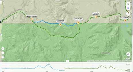
I've secured permits for a Thorofare/South Boundary Trail hike from Nine Mile to the South Park Entrance. Night 6, I am intending to stay outside of the park, originally planning to stay on the South Boundary Trail, hopscotching along the southern park boundary.

Trying to be mindful of park camping regulations, I am a bit worried about the availability of good, legal, and safe camping spots along the south boundary in the Teton Wilderness, especially since a good chunk is at elevation.

I'm considering diving south south onto the Wolverine Creek Trail. This adds a little over three miles and reduces the elevation gain by about 1,000 ft, and pretty much guarantees some more camping options.

Anyone taken this route? How well is the trail marked and defined? How is the camping along the south boundary? Any concerns about the alternate route?

Screenshot (7).png
 

TheMountainRabbit

"Because it's there."
.
Joined
Feb 15, 2020
Messages
332
It's a straightforward trail - you shouldn't have a problem staying on route either way.

Personally I'd vote for staying on the South Boundary trail where it traverses Big Game Ridge, because it's one of the highlights of the boundary trail for me.

That said, the Wolverine Creek route is also a good option and has some better dispersed camping options. (Though you'll safely find a decent spot either way.)

6M3 is an awesome site, so enjoy that one.

EDIT: I looked a little closer at your map and realized you're talking about following Wolverine Creek itself rather than the longer cutoff. Be sure you know when to leave the main trail and follow the creek. There is a trail there, but I don't remember any signage. Still fairly easy to follow the route - just follow the creek downstream until it hits the Snake River.
 
Last edited:

Bob

Trailmaster
Joined
Mar 3, 2013
Messages
3,741
Same, Stay on boundary trail. .. easy to get off Park.....
 
Similar threads
Thread starter Title Forum Replies Date
tropicalwanderer YNP : 8/31-9/7 : Heart Lake to Nine Mile via CDT, South Boundary and Thorofare Trip Planning 9
C Thorofare Trip - September 2023 Trip Planning 3
ridings82 Album Thorofare Photography 4
Christo Water availability:Thorofare Yellowstone Trip Planning 6
marmot_boi Thorofare trip Trip Planning 4
B Thorofare loop (almost) Cabin Creek, Hawk's Rest, Ishawooa Creek 8/11-19 Backpacking 55
norwegianxplorer Greater Yellowstone part 2, from the Headwaters of Yellowstone River, through the Thorofare, Overlook Mountain, Rampart Creek Backpacking 9
B Thorofare loop from Deer Creek Trip Planning 20
TeamJenkins17 Thorofare/Teton Wilderness Trip Trip Planning 12
TeamJenkins17 Yellowstone Thorofare to Brooks lake trip next year. Trip Planning 6
S Deer Creek into the Thorofare Trip Planning 6
E Thorofare mid september 2018 Trip Planning 16
K The Thorofare and the Absaroka Wilderness Backpacking 9
J Thorofare 2018 Trip Planning 14
Jason Bradshaw Thorofare Trail Backpacking 7
J Invite Packrafting the Thorofare area Meet Up (Members Only) 5
V Yellowstone - Thorofare - Solo? Trip Planning 15
Keith Yellowstone Thorofare (8/11/14 to 8/17/14) Backpacking 7
Joey Invite Yellowstone's Thorofare and Gallatin/Sky Rim area Meet Up (Members Only) 4
balzaccom South America Everything Else 1
BobFink Yellowstone South Entrance to Fox Creek via Basin Creek Cutoff - Labor Day 2022 Trip Reports 4
scatman South Ridge of City Creek Canyon - January 28, 2023 Hiking & Camping 4
SteveR Coyote Buttes South- New Daily Permit Process Trip Planning 8
wsp_scott Big South Fork Bikepacking Backpacking 1
S Driving to poverty flats (South Coyote Buttes) on AWD Trip Planning 11
P Yellowstone--Heart Lake to South Entrance Backpacking 13
John Goering Tobacco Root Mountains South Meadow Creek Off Road 1
BJett Big South Fork National River & Recreation Area Packraft/Backpack Loop (TN) Backpacking 6
balzaccom South by Southwest from Napa Hiking & Camping 4
Janice Vermillion Cliffs Trip - Part 2 - White Pocket & Coyote Buttes South Hiking & Camping 7
Janice The Wave - and SO MUCH MORE! (Coyote Buttes North, South, White Pocket, Buckskin, Condors, Bighorns...) - Part 1 Hiking & Camping 14
dhertbag Camping at Cottonwood Cove - Coyote Buttes South Trip Planning 11
wsp_scott Honey Creek (Big South Fork) Backpacking 9
Chuck the Mauler Sierra North Lake / South Lake "loop" questions Trip Planning 10
wsp_scott Big South Fork Views Backpacking 14
S Conejos - South San Juan Wilderness Backpacking 2
Jammer Sequoia: Upper Kern and Lake South America Backpacking 12
kwc Chimney Mountain, South Central Adirondacks Hiking & Camping 3
kwc Hiking in the South Central Adirondacks Hiking & Camping 1
I Water in Frisky Creek south of Highway 12 in the Grand Staircase? Trip Planning 0
K Floating down South Fork of the Snake (ID) Trip Planning 1
regehr Dirty Devil South Trip Reports 11
Nick Coyote Buttes South - Jan 18, 2020 Trip Planning 1
TrailScot Quite the Adventure, South of Moab, Across the Colorado Plateau, May 2019 - Part 4 Backpacking 17
TrailScot Quite the Adventure, South of Moab, Across the Colorado Plateau, May 2019 - Part 3 Backpacking 8
TrailScot Quite the Adventure - South of Moab, Across the Colorado Plateau, May 2019 - Part 2 Backpacking 14
TrailScot Quite the Adventure - South of Moab, Across the Colorado Plateau, May 2019 - Part 1 Backpacking 10
regehr south waterpocket fold backpack Trip Planning 27
Titans Prescribed burn South Monroe Mountain- photos from Capitol Reef area Photography 0
Chuck the Mauler North Lake - South Lake questions Trip Planning 4

Similar threads

Don't like ads? Become a BCP Supporting Member and kiss them all goodbye. Click here for more info.

Top