- Joined
- Aug 9, 2007
- Messages
- 12,955
If you are one of the people who came on this trip, feel totally free to post your own new trip report or if you'd prefer you can post your pics here.
For the first two days of the Zion Backcountry-Fest, we backpacked the West Rim Trail. It's something I've always had on my list but was never really that compelled to go knock it out. But once you add in The Subway the next day and that sounds like a nice package.
We set sail for Zion early Thursday afternoon with enough time to get to the Kolob Visitor Center to pickup our permit. Yellowstone 1 and I drove down in my truck and Summit and FourisTheNewOne drove down a bit behind us and hiked Bikini-errr---Kanarra Creek along the way.
Cave Valley, en route to our spot for the night.

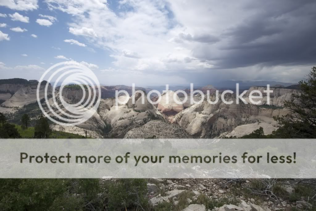
We picked a spot I had used before up on the Kolob Terrace Road. What I didn't know about the spot before was that there is a phenomenal view just 100 yards from the campsite. The last time we were in and out and never bothered walking down there. The downside to this was that the wind was blowing like a hurricane at the edge of that cliff. Walk 20 feet into the trees, not so bad, but standing at the edge of that cliff was intense. I still waited it out hoping for a good sunset but this was about as good as it got.

As usual, a couple of us, myself included, we were up way too late considering we were heading out backpacking in the morning. I must be getting used to it though because after a good breakfast I had already forgotten about it and was getting stoked to hit the trail. We packed up and made out way up to Lava Point to the West Rim Trailhead where we met blueeyes, Spencer, barl0w and Saori who were already there waiting for us.
The West Rim Trail starts out about how I had expected. Way up high in the ponderosas.

But with plenty of views in between.

A few miles in, we finally reached out first big view into the depths of Zion. I had mistakenly thought this was the Right Fork of North Creek at the time but after looking at the map again, I'm pretty sure this is actually the Left Fork, location of the Subway where we would be in a couple days.

After a bit over 5 miles, we were in Potato Hollow and our only source of water until the following day. It was still quite early in the day so we filled up out bladders and relaxed for a while.

A short distance from the Potato Hollow Spring is the rim of Imlay Canyon. It is an incredible site and totally worth checking out if you ever find yourself walking through Potato Hollow. It's only a couple hundred yards at most.

The ledges here were a bit shocking to me. It's so weird to be able to stand literally on the ledge of a shear nearly 1000 foot drop like that. Pictures can not do it justice. I got dizzy just looking through my view finder here.

Imlay Canyon

We walked the rim for a bit and started to hear running water. We followed the sound until we found a place to scramble down into the head of Imlay.

We found a series of small drops and pot holes with springs flowing in from several places. We were stopped by a 20 foot drop into a grotto.

But I still found one big enough for me to take a quick dip in. AhhhHHHH!!!

Back up on the rim, the water flowing into Imlay was much better than the stuff that everyone pumps out of up further in Potato Hollow. If you're looking for water, follow it down to here and make sure you're getting the best stuff.

After we were fed and loaded up with water, we set out for campsite #4, our home for the night. The trail climbs sharply after leaving Potato Hollow and becomes heavily vegetated compared to the first section.

After the first crest, the trail drops back down and crosses over to the mesa in the distance where campsites 6, 5, 4 and 3 are located. This little ridge that goes past the Hammerhead overlook was one of my favorite parts of the hike this day.

Ah but what's this? A bit of drama on the horizon. And I didn't bring a tent on this trip. Hmmm....

But it made for nice light. I absolutely loved all the white trees and huge pink flowers along the trail.

And the storm moves closer...


Chere and Spencer climbing the last stretch onto the mesa as the storm is almost upon us.

As we got onto the top of the mesa, we really started booking it to camp. We had been moving quite slow at that point, taking our time enjoying the scenery and taking photos. But now the realization that we were still a pretty far out from camp with a storm on top of us set in. Even more so because we realized just how exposed we were up there. It felt like we were on the highest, barest ridge for miles. Great place to be with thunder rumbling around you.


We made it to camp without a drop of rain and started figuring out a way to create a shelter. A couple of us had no tent and a couple had a tent but no rain fly. So we made a nice little lean-to out of my tarp. We didn't end using it as it only rained a few drops, but it was still fun to make. Totally forget to get a picture of it though!
Later in the evening, the storm cleared out and we had beautiful light although it stayed pretty windy.


The view about 50 yards from our campsite. All of the sites along this section of trail (3, 4, 5 and 6) have excellent views like this. Some a little better than others.


The moment the sun went down the winds picked up big time. Most everyone ran for their tents and sleeping bags but I stayed up for a while with Chere and Spencer huddled up on my tarp. It was Chere's birthday the next day so we had to celebrate a bit.
Despite being so windy that night I slept quite well out on the tarp. I left my down jacket on for a while with my bag unzipped and arms out but then later in the night the wind calmed a bit and I was able to lose the down jacket and put it back into pillow duty so I was able to sleep better after that. I definitely would have liked a tent that night though.
The next day we all kind of split up. Bill and Clint are anti-social elitists so they ditched us all and hiked out early, meanwhile the Barlows went and hiked Angel's Landing while Donnie, Chere, Spencer and I made our way down the trail. We stopped to fill up at Cabin Spring along the way. The water was cold and delicious despite being a tiny little puddle. And the view just below it was phenomenal.


We could see the trail way down below us but had no idea how it was going to get there so fast.

Okay, now I get it. The trail switch backed straight down the face of the cliff about 1000 feet to the valley below.

That's the head of Behunin Canyon in the top center.


There were flowers galore on this trip but I did a poor job of capturing them due to the lens I left on.

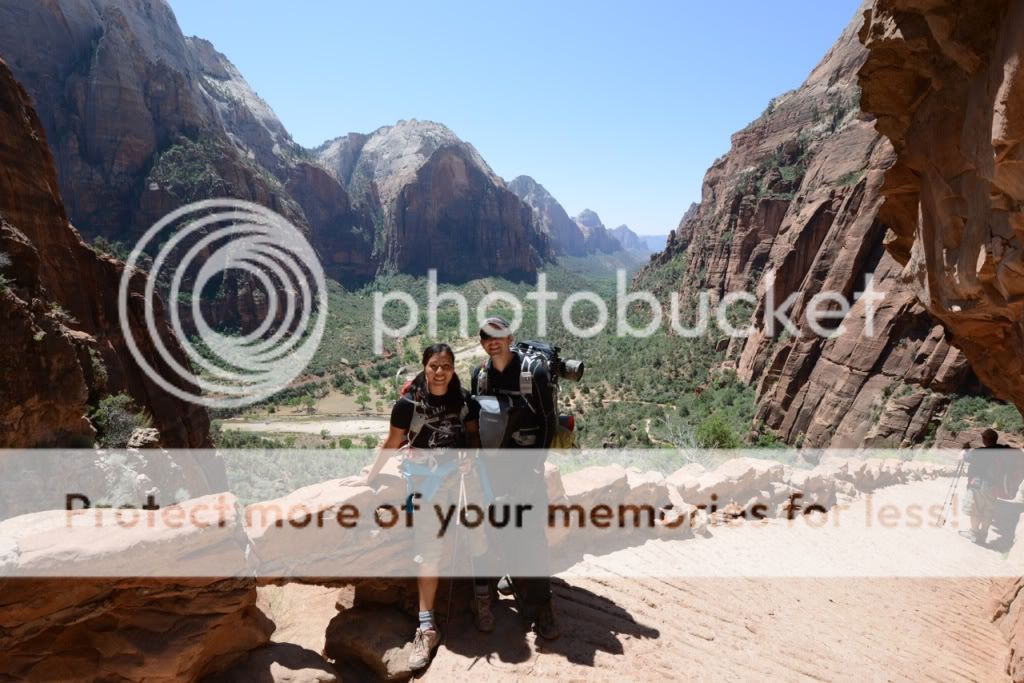
After the long hike down we had one more big climb up before we were finally to the edge of Zion Canyon. The trail here literally passes inches from sheer drops like this.

Once we got to Scout Lookout we were in people hell. From seeing almost no one to feeling like we were in New York in a matter of minutes. Luckily we ran into the Barlows again here right after they finished Angel's Landing. We also ran into cirrus2000 who was in town from Canada camping and doing canyons. Great to see you, Kev!

I was able to take a photo in Refrigerator Canyon without someone in it. I feel I deserve a medal.

We were all hiking together, talking and having a good time until we got to this point. I saw it down there.... calling to me. Cold water in the Virgin River! I told the group I would meet them at the bottom and went running down the switchbacks in search of a swimming hole.

That'll do! I hiked down and jumped right in. Everyone caught up as I was getting out.

But I guess I wasn't the only one who wanted a dip because when I caught up to them, they were doing the same thing!

After a dip in the Virgin, we all hopped on the shuttle, stinking like backpackers and pissing off all the clean, happy tourists with our big packs. From there it was on to the visitor's center to pickup our permits for The Subway, grab some wetsuits, lunch and then back up to the Kolob Terrace Road to pickup our cars and find camp. Next stop, The Subway!
The West Rim far exceeded my expectations. I'm really looking forward to doing it again someday but without the wind. I wouldn't change a lot about how we did it. Definitely start from Lava Point and definitely camp on the mesa with sites 3-6, although the site at Potato Hollow wouldn't be too bad with that epic view into Imlay nearby. Hell, even the sites over at Cabin Spring would be pretty nice. No matter where you camp, you really can't go wrong. Great hike!
Featured image for slideshow:

For the first two days of the Zion Backcountry-Fest, we backpacked the West Rim Trail. It's something I've always had on my list but was never really that compelled to go knock it out. But once you add in The Subway the next day and that sounds like a nice package.
We set sail for Zion early Thursday afternoon with enough time to get to the Kolob Visitor Center to pickup our permit. Yellowstone 1 and I drove down in my truck and Summit and FourisTheNewOne drove down a bit behind us and hiked Bikini-errr---Kanarra Creek along the way.
Cave Valley, en route to our spot for the night.
We picked a spot I had used before up on the Kolob Terrace Road. What I didn't know about the spot before was that there is a phenomenal view just 100 yards from the campsite. The last time we were in and out and never bothered walking down there. The downside to this was that the wind was blowing like a hurricane at the edge of that cliff. Walk 20 feet into the trees, not so bad, but standing at the edge of that cliff was intense. I still waited it out hoping for a good sunset but this was about as good as it got.
As usual, a couple of us, myself included, we were up way too late considering we were heading out backpacking in the morning. I must be getting used to it though because after a good breakfast I had already forgotten about it and was getting stoked to hit the trail. We packed up and made out way up to Lava Point to the West Rim Trailhead where we met blueeyes, Spencer, barl0w and Saori who were already there waiting for us.
The West Rim Trail starts out about how I had expected. Way up high in the ponderosas.
But with plenty of views in between.
A few miles in, we finally reached out first big view into the depths of Zion. I had mistakenly thought this was the Right Fork of North Creek at the time but after looking at the map again, I'm pretty sure this is actually the Left Fork, location of the Subway where we would be in a couple days.
After a bit over 5 miles, we were in Potato Hollow and our only source of water until the following day. It was still quite early in the day so we filled up out bladders and relaxed for a while.
A short distance from the Potato Hollow Spring is the rim of Imlay Canyon. It is an incredible site and totally worth checking out if you ever find yourself walking through Potato Hollow. It's only a couple hundred yards at most.
The ledges here were a bit shocking to me. It's so weird to be able to stand literally on the ledge of a shear nearly 1000 foot drop like that. Pictures can not do it justice. I got dizzy just looking through my view finder here.
Imlay Canyon
We walked the rim for a bit and started to hear running water. We followed the sound until we found a place to scramble down into the head of Imlay.
We found a series of small drops and pot holes with springs flowing in from several places. We were stopped by a 20 foot drop into a grotto.
But I still found one big enough for me to take a quick dip in. AhhhHHHH!!!
Back up on the rim, the water flowing into Imlay was much better than the stuff that everyone pumps out of up further in Potato Hollow. If you're looking for water, follow it down to here and make sure you're getting the best stuff.
After we were fed and loaded up with water, we set out for campsite #4, our home for the night. The trail climbs sharply after leaving Potato Hollow and becomes heavily vegetated compared to the first section.
After the first crest, the trail drops back down and crosses over to the mesa in the distance where campsites 6, 5, 4 and 3 are located. This little ridge that goes past the Hammerhead overlook was one of my favorite parts of the hike this day.
Ah but what's this? A bit of drama on the horizon. And I didn't bring a tent on this trip. Hmmm....
But it made for nice light. I absolutely loved all the white trees and huge pink flowers along the trail.
And the storm moves closer...
Chere and Spencer climbing the last stretch onto the mesa as the storm is almost upon us.
As we got onto the top of the mesa, we really started booking it to camp. We had been moving quite slow at that point, taking our time enjoying the scenery and taking photos. But now the realization that we were still a pretty far out from camp with a storm on top of us set in. Even more so because we realized just how exposed we were up there. It felt like we were on the highest, barest ridge for miles. Great place to be with thunder rumbling around you.
We made it to camp without a drop of rain and started figuring out a way to create a shelter. A couple of us had no tent and a couple had a tent but no rain fly. So we made a nice little lean-to out of my tarp. We didn't end using it as it only rained a few drops, but it was still fun to make. Totally forget to get a picture of it though!
Later in the evening, the storm cleared out and we had beautiful light although it stayed pretty windy.
The view about 50 yards from our campsite. All of the sites along this section of trail (3, 4, 5 and 6) have excellent views like this. Some a little better than others.
The moment the sun went down the winds picked up big time. Most everyone ran for their tents and sleeping bags but I stayed up for a while with Chere and Spencer huddled up on my tarp. It was Chere's birthday the next day so we had to celebrate a bit.
Despite being so windy that night I slept quite well out on the tarp. I left my down jacket on for a while with my bag unzipped and arms out but then later in the night the wind calmed a bit and I was able to lose the down jacket and put it back into pillow duty so I was able to sleep better after that. I definitely would have liked a tent that night though.
The next day we all kind of split up. Bill and Clint are anti-social elitists
so they ditched us all and hiked out early, meanwhile the Barlows went and hiked Angel's Landing while Donnie, Chere, Spencer and I made our way down the trail. We stopped to fill up at Cabin Spring along the way. The water was cold and delicious despite being a tiny little puddle. And the view just below it was phenomenal.We could see the trail way down below us but had no idea how it was going to get there so fast.
Okay, now I get it. The trail switch backed straight down the face of the cliff about 1000 feet to the valley below.
That's the head of Behunin Canyon in the top center.
There were flowers galore on this trip but I did a poor job of capturing them due to the lens I left on.
After the long hike down we had one more big climb up before we were finally to the edge of Zion Canyon. The trail here literally passes inches from sheer drops like this.
Once we got to Scout Lookout we were in people hell. From seeing almost no one to feeling like we were in New York in a matter of minutes. Luckily we ran into the Barlows again here right after they finished Angel's Landing. We also ran into cirrus2000 who was in town from Canada camping and doing canyons. Great to see you, Kev!
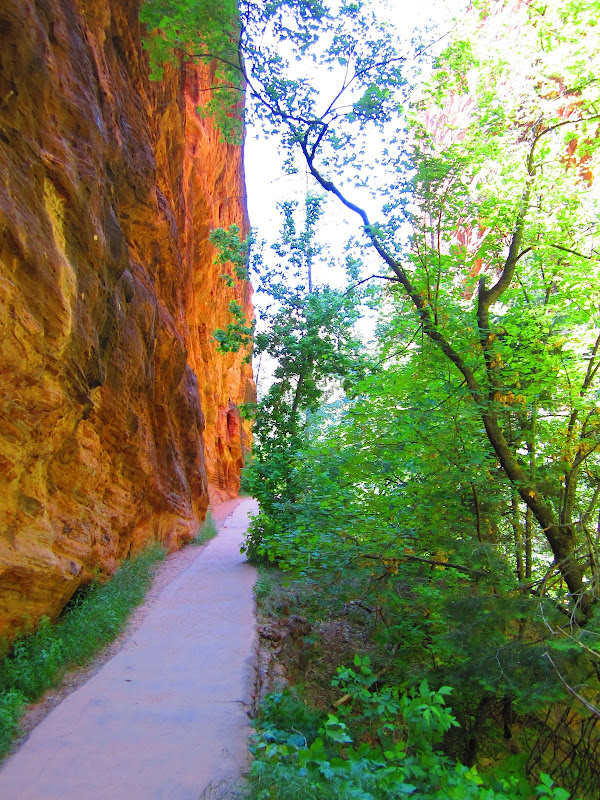
I was able to take a photo in Refrigerator Canyon without someone in it. I feel I deserve a medal.
We were all hiking together, talking and having a good time until we got to this point. I saw it down there.... calling to me. Cold water in the Virgin River! I told the group I would meet them at the bottom and went running down the switchbacks in search of a swimming hole.
That'll do! I hiked down and jumped right in. Everyone caught up as I was getting out.
But I guess I wasn't the only one who wanted a dip because when I caught up to them, they were doing the same thing!
After a dip in the Virgin, we all hopped on the shuttle, stinking like backpackers and pissing off all the clean, happy tourists with our big packs. From there it was on to the visitor's center to pickup our permits for The Subway, grab some wetsuits, lunch and then back up to the Kolob Terrace Road to pickup our cars and find camp. Next stop, The Subway!
The West Rim far exceeded my expectations. I'm really looking forward to doing it again someday but without the wind. I wouldn't change a lot about how we did it. Definitely start from Lava Point and definitely camp on the mesa with sites 3-6, although the site at Potato Hollow wouldn't be too bad with that epic view into Imlay nearby. Hell, even the sites over at Cabin Spring would be pretty nice. No matter where you camp, you really can't go wrong. Great hike!
Featured image for slideshow: