- Joined
- Dec 23, 2013
- Messages
- 4,504
Let me apologize at the beginning as this will be a long report (image wise). I thought about breaking it up into separate days, but I believe that I am too lazy for that, so for those who dislike wading through long reports, just bite off little pieces every now and then. ")
I had originally planned to hike the John Muir Trail during the summer between my son's final year of high school and his first year of college. So I submitted my request for a permit to attempt the JMT starting in July, but unfortunately we did not draw one of them for our time frame. This left us with plan B which would be the Theodore Solomon's Trail (TST).
The TST essentially parallels the JMT, to the west, through the Sierras. It is 272 miles long and begins at Glacier Point in Yosemite and heads south to end at Horseshoe Meadow , which is roughly 10 miles south of Mount Whitney. The idea was conceived back in the 1970's as an alternative to the JMT, though over the years it never received an official trail designation from the Park Service or the Forest Service whose land it passes through. Because it is not recognized officially, there are sections that have not been maintained for years (decades maybe?). So, potential route finding along the way may be necessary.

The Theodore Solomon's Trail
We decided that we would attempt the TST in the opposite direction, from south to north. Along the way, we would have three resupply points: The first at Silver City Resort (three miles from Mineral King), the second at Cedar Grove Visitors Center (six miles from Road's End) and the last at Huntington Lake Post Office (six miles down the road from the trailhead). We also understood that there was record or near record snowfall in the Sierras this year and runoff from the snow melt would be an issue. Particularly worrisome would be the ford of the Middle Fork of the Kings River at Simpson Meadow (roughly the halfway point). The footbridge that spanned the River washed away in the 70's and it has never been replaced by the Park Service. So we agreed that if the river was not fordable, then we would call it a trip.
Once we made it to our second resupply point at Cedar Grove, I walked up to the pack station to see if the horsemen new if the Middle Fork of the Kings could be forded by a backpacker. The owners told me "No!" They were not even going to attempt to take horses across it until September. This essentially ended our trek at eleven days.
We had planned to hike approximately ten miles a day, though some ended up being a little shorter and one day much longer at 17.5 miles due to resupply issues and backtracking to cross a river. We saw wildlife throughout that included bears, deer, marmots, grouse, owls, lizards, hawks and one snake. The wildflowers along the route were in full bloom and the scenery was breathtaking. The only people that we saw in the backcountry were near tourist points such as Mineral King and Cedar Grove, otherwise we had it all to ourselves. Creek and River Crossings were sketchy if not treacherous and trail conditions were all over the map. Water was everywhere and we ended up naming our trip "Rager" for all the fast moving water we encountered and heard.
Well, I'll let the images tell the rest of the story.

The tap room at the Tonopah Brewery on our way to Lone Pine, CA. These folks surprisingly have excellent barbecue.

Mount Whitney on a rainy afternoon

The switchbacks up to Horseshoe Meadow as seen from Lone Pine, CA

Day 1 - Horseshoe Meadow to campsite along Golden Trout Creek

At the Trailhead in Horseshoe Meadow

On top of Cottonwood Pass

Big Whitney Meadow

Day 2 - Golden Trout Creek to Natural Bridge

Golden Trout Creek

Red Fir country

Day 3 - Natural Bridge to Coyote Pass

Looking in the direction of Coyote Pass

Footbridge that spans the Kern River

Hocket Trail

View looking back at the Trout Creek Drainage as we are hiking up towards Coyote Pass

Falls on Coyote Creek

Upper Coyote Creek

View to the east from Coyote Pass

Entering Sequoia National Forest - this sign is on Coyote Pass

Day 4 - Coyote Pass to Green Meadow

Red Fir on trail - these were big trees and hard to climb over and a long way to walk around - these were common occurrences.

View to the north towards Farewell Gap and Vandever Mountain and the headwaters of the Little Kern River

Old Quin Cabin

Day 5 - Green Meadow to Deer Creek

Sand Meadows

Ranger Station at Hockett Meadows - lots of deer to the south of the cabin

I slipped off this log into Clover Creek

Sunset on Deer Creek

Day 6 - Resupply Day - from Deer Creek to Silver City Resort and back to Mineral King

Ranger Station at Mineral King

Silver City Resort - where we picked up our 5 gallon resupply buckets

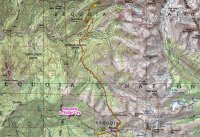
Day 7 (a) - two part map - from Mineral King to Bearpaw Meadow - this was our 17.5 mile day

Day 7 (b) - When we reached the Middle Fork of the Kaweah, we had to backtrack (it was not fordable) to the footbridge. This added about 2.5 more miles to our day.

I had to take a picture of this at the Sawtooth Trailhead. People secured tarps underneath their vehicles in order to keep marmots from damaging them

Looking back at Farewell Gap, Vandever Mountain and Florence Peak

Timber Gap Creek

View of what lays ahead of us - looking down Timber Gap Creek

Cliff Creek

Redwood Meadow Grove - The image on Hugh Jr.'s face was priceless when he saw his first Sequoia tree.

Ranger Station at Redwood Meadow

Looking up the Middle Fork of the Keweah towards the High Sierras

Jr., after falling in Eagle Scout Creek - nasty crossing

Middle Fork of the Keweah

Heading up towards Bearpaw Meadow - looking east towards the Great Western Divide

Looking back in the direction we had come.

Heading up towards Bearpaw Meadow - looking east towards the Great Western Divide

Heading up towards Bearpaw Meadow - looking east towards the Great Western Divide

Heading up towards Bearpaw Meadow - looking east towards the Great Western Divide

Day 8 - Up and over Elizabeth Pass and down into Deadman Canyon - From a mountain scenery perspective, the best day of the trip

Picture opportunity as we stopped to refill water bottles

The mountain views started rolling out in front of us (in this case behind us) as we made our way towards Elizabeth Pass


Looking down into the Middle Fork of the Kaweah Valley

Not the best sun angle, but the scenery was overwhelming. I just wanted to stop and take it all in. - Looking towards the Great Western Divide


The High Sierra Trail switchbacks on the opposite side of the valley

Looking north from the trail towards the Kings-Kaweah Divide

Impressive waterfalls along the way too.

A peak into the Lone Pine Drainage and basin

A look back down into the Middle Fork of the Kaweah Drainage

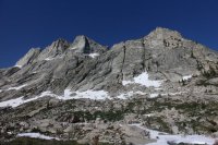
The High Sierras

First good look up to Elizabeth Pass

Looking up at the Kings-Kaweah Divide

Jr. - taking a break after crossing the creek that flows from Lonely Lake

A deer comes to visit

Looking up at Elizabeth Pass - the ground at this point is just covered with running water

Hiking through snow at this point

He was pretty tired at this point - almost to the pass

On top of Elizabeth Pass

A peak down the north side of the pass

A look down into Deadman Canyon

Jr., starting to lag behind a bit

We had to cross the snow bridge at the edge of the falls in this shot in order to get down. I was pretty nervous when crossing

Day 9 - Hike down Deadman Canyon to the Roaring River Patrol Cabin - another great day of mountain scenery

View to the east of our campsite

camped on Deadman Creek

Looking down Deadman Canyon

Deadman Canyon

Looking back up Deadman Canyon

Deadman Canyon

Deadman Canyon

View to the west in Deadman Canyon
Fording Deadman Creek - these fords wore me out and i didn't like hitting them late in the day when I was tired

Deadman Canyon

Roaring River Ranger Station

Roaring River

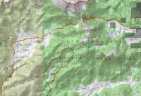
Day 10 - Roaring River Ranger Station to Bubbs Creek - the best trail of the trip was heading up Avalanche Pass
 View on our way up to Avalanche Pass

View heading up Avalanche Pass

On Avalanche Pass

View of the High Sierras heading down the north side of Avalanche Pass - we lost the trail numerous times coming off the pass

View coming down Avalanche Pass

Granite stairs, complements of the CCC, built into the granite cliff on our way down to Bubbs Creek

Day 11 - Bubbs Creek to Cedar Grove

Bubbs Creek

A view into Kings Canyon

Fording Bubbs Creek

The view in Kings Canyon

Fire still smoldering along the trail near Road's End

Sign at Road's End and you'll get no argument from me.
At this point we made our way down to Cedar Grove for our second resupply. The rangers did not know the condition of the ford at Simpson Meadow, so I had to head up to the pack station to find whether of not the Middle Fork of the Kings was fordable. Unfortunately, this turned out to be the end of our trip when they told me we could not cross, but an excellent one none the less.
I had originally planned to hike the John Muir Trail during the summer between my son's final year of high school and his first year of college. So I submitted my request for a permit to attempt the JMT starting in July, but unfortunately we did not draw one of them for our time frame. This left us with plan B which would be the Theodore Solomon's Trail (TST).
The TST essentially parallels the JMT, to the west, through the Sierras. It is 272 miles long and begins at Glacier Point in Yosemite and heads south to end at Horseshoe Meadow , which is roughly 10 miles south of Mount Whitney. The idea was conceived back in the 1970's as an alternative to the JMT, though over the years it never received an official trail designation from the Park Service or the Forest Service whose land it passes through. Because it is not recognized officially, there are sections that have not been maintained for years (decades maybe?). So, potential route finding along the way may be necessary.
The Theodore Solomon's Trail
We decided that we would attempt the TST in the opposite direction, from south to north. Along the way, we would have three resupply points: The first at Silver City Resort (three miles from Mineral King), the second at Cedar Grove Visitors Center (six miles from Road's End) and the last at Huntington Lake Post Office (six miles down the road from the trailhead). We also understood that there was record or near record snowfall in the Sierras this year and runoff from the snow melt would be an issue. Particularly worrisome would be the ford of the Middle Fork of the Kings River at Simpson Meadow (roughly the halfway point). The footbridge that spanned the River washed away in the 70's and it has never been replaced by the Park Service. So we agreed that if the river was not fordable, then we would call it a trip.
Once we made it to our second resupply point at Cedar Grove, I walked up to the pack station to see if the horsemen new if the Middle Fork of the Kings could be forded by a backpacker. The owners told me "No!" They were not even going to attempt to take horses across it until September. This essentially ended our trek at eleven days.
We had planned to hike approximately ten miles a day, though some ended up being a little shorter and one day much longer at 17.5 miles due to resupply issues and backtracking to cross a river. We saw wildlife throughout that included bears, deer, marmots, grouse, owls, lizards, hawks and one snake. The wildflowers along the route were in full bloom and the scenery was breathtaking. The only people that we saw in the backcountry were near tourist points such as Mineral King and Cedar Grove, otherwise we had it all to ourselves. Creek and River Crossings were sketchy if not treacherous and trail conditions were all over the map. Water was everywhere and we ended up naming our trip "Rager" for all the fast moving water we encountered and heard.
Well, I'll let the images tell the rest of the story.
The tap room at the Tonopah Brewery on our way to Lone Pine, CA. These folks surprisingly have excellent barbecue.
Mount Whitney on a rainy afternoon
The switchbacks up to Horseshoe Meadow as seen from Lone Pine, CA
Day 1 - Horseshoe Meadow to campsite along Golden Trout Creek
At the Trailhead in Horseshoe Meadow
On top of Cottonwood Pass
Big Whitney Meadow
Day 2 - Golden Trout Creek to Natural Bridge
Golden Trout Creek
Red Fir country
Day 3 - Natural Bridge to Coyote Pass
Looking in the direction of Coyote Pass
Footbridge that spans the Kern River
Hocket Trail
View looking back at the Trout Creek Drainage as we are hiking up towards Coyote Pass
Falls on Coyote Creek
Upper Coyote Creek
View to the east from Coyote Pass
Entering Sequoia National Forest - this sign is on Coyote Pass
Day 4 - Coyote Pass to Green Meadow
Red Fir on trail - these were big trees and hard to climb over and a long way to walk around - these were common occurrences.
View to the north towards Farewell Gap and Vandever Mountain and the headwaters of the Little Kern River
Old Quin Cabin
Day 5 - Green Meadow to Deer Creek
Sand Meadows
Ranger Station at Hockett Meadows - lots of deer to the south of the cabin
I slipped off this log into Clover Creek
Sunset on Deer Creek
Day 6 - Resupply Day - from Deer Creek to Silver City Resort and back to Mineral King
Ranger Station at Mineral King
Silver City Resort - where we picked up our 5 gallon resupply buckets
Day 7 (a) - two part map - from Mineral King to Bearpaw Meadow - this was our 17.5 mile day
Day 7 (b) - When we reached the Middle Fork of the Kaweah, we had to backtrack (it was not fordable) to the footbridge. This added about 2.5 more miles to our day.
I had to take a picture of this at the Sawtooth Trailhead. People secured tarps underneath their vehicles in order to keep marmots from damaging them
Looking back at Farewell Gap, Vandever Mountain and Florence Peak
Timber Gap Creek
View of what lays ahead of us - looking down Timber Gap Creek
Cliff Creek
Redwood Meadow Grove - The image on Hugh Jr.'s face was priceless when he saw his first Sequoia tree.
Ranger Station at Redwood Meadow
Looking up the Middle Fork of the Keweah towards the High Sierras
Jr., after falling in Eagle Scout Creek - nasty crossing
Middle Fork of the Keweah
Heading up towards Bearpaw Meadow - looking east towards the Great Western Divide
Looking back in the direction we had come.
Heading up towards Bearpaw Meadow - looking east towards the Great Western Divide
Heading up towards Bearpaw Meadow - looking east towards the Great Western Divide
Heading up towards Bearpaw Meadow - looking east towards the Great Western Divide
Day 8 - Up and over Elizabeth Pass and down into Deadman Canyon - From a mountain scenery perspective, the best day of the trip
Picture opportunity as we stopped to refill water bottles
The mountain views started rolling out in front of us (in this case behind us) as we made our way towards Elizabeth Pass
Looking down into the Middle Fork of the Kaweah Valley
Not the best sun angle, but the scenery was overwhelming. I just wanted to stop and take it all in. - Looking towards the Great Western Divide
The High Sierra Trail switchbacks on the opposite side of the valley
Looking north from the trail towards the Kings-Kaweah Divide
Impressive waterfalls along the way too.
A peak into the Lone Pine Drainage and basin
A look back down into the Middle Fork of the Kaweah Drainage
The High Sierras
First good look up to Elizabeth Pass
Looking up at the Kings-Kaweah Divide
Jr. - taking a break after crossing the creek that flows from Lonely Lake
A deer comes to visit
Looking up at Elizabeth Pass - the ground at this point is just covered with running water
Hiking through snow at this point
He was pretty tired at this point - almost to the pass
On top of Elizabeth Pass
A peak down the north side of the pass
A look down into Deadman Canyon
Jr., starting to lag behind a bit
We had to cross the snow bridge at the edge of the falls in this shot in order to get down. I was pretty nervous when crossing
Day 9 - Hike down Deadman Canyon to the Roaring River Patrol Cabin - another great day of mountain scenery
View to the east of our campsite
camped on Deadman Creek
Looking down Deadman Canyon
Deadman Canyon
Looking back up Deadman Canyon
Deadman Canyon
Deadman Canyon
View to the west in Deadman Canyon
Fording Deadman Creek - these fords wore me out and i didn't like hitting them late in the day when I was tired
Deadman Canyon
Roaring River Ranger Station
Roaring River
Day 10 - Roaring River Ranger Station to Bubbs Creek - the best trail of the trip was heading up Avalanche Pass
View on our way up to Avalanche Pass View heading up Avalanche Pass
On Avalanche Pass
View of the High Sierras heading down the north side of Avalanche Pass - we lost the trail numerous times coming off the pass
View coming down Avalanche Pass
Granite stairs, complements of the CCC, built into the granite cliff on our way down to Bubbs Creek
Day 11 - Bubbs Creek to Cedar Grove
Bubbs Creek
A view into Kings Canyon
Fording Bubbs Creek
The view in Kings Canyon
Fire still smoldering along the trail near Road's End
Sign at Road's End and you'll get no argument from me.
At this point we made our way down to Cedar Grove for our second resupply. The rangers did not know the condition of the ford at Simpson Meadow, so I had to head up to the pack station to find whether of not the Middle Fork of the Kings was fordable. Unfortunately, this turned out to be the end of our trip when they told me we could not cross, but an excellent one none the less.
 Love it!
")


