Joey
walking somewhere
- Joined
- Apr 1, 2014
- Messages
- 878
This is a 5 day backpack in Idaho's Sawtooth Wilderness. I did this last year (2015) at the very end of October.
I highly recommend checking out my video for it, even if just for the highlight reel at the beginning. Its one of the better video's i've put together, and some of the footages comes out nicer than my photo's in this trip report.
The trip started and ended at Pettit Lake. You can see the route here:
Click here to view on CalTopo
There really isn't much of a story to this one, but the scenery was beautiful.
I had spent some time in Stanley several years ago, doing some lower elevation hiking and camping. I had been wanting to check out the high country ever since, but it just hadn't happened. Then this last October, I found myself working for @Bob , helping him install windows at his house in Island Park. I had been planning one last Yellowstone adventure, but really wasn't thrilled about the cold weather moving in. It was warmer in the Sawtooths, so I decided to head over there. Bob had shown me several different ideal routes, but I really wasn't sure exactly what I was going to do. I decided to call @Ben , and was on the phone with him as I drove south from Stanley He suggested doing the Alice-Toxaway Lakes Loop, but also said Vernon and Imogene Lakes were worth checking out. So I decided to check those lakes out.
I got to Pettit Lake in the afternoon. It was close to 4pm when I hit the trail, which was pretty late in the day for late October. I really wasn't sure how many days I was going to go out for, so I threw in enough food to last me a week . There were a few cars in the parking lot, but I would only see 2 people the entire time I was out there, 2 guys from Salt Lake.

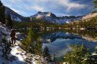
Pettit Lake from the starting trail head. The Alice Lake, Twin Lakes drainage is dead ahead. I would come down from that direction to end the trip.
The first thing I noticed was how relaxing it was not having to be aware of grizzly bears.") I took the trail towards Yellow Belly Lake, and then headed up the Toxaway Lake drainage. Most of the trail winds through wooded forest.
I took the trail towards Yellow Belly Lake, and then headed up the Toxaway Lake drainage. Most of the trail winds through wooded forest.

A minor stream crossing a few miles in.
I hiked through the forest faster than normal, intent on making it to Farley Lake before dark. As I climbed elevation, I reached open meadows with spectacular views back behind. I think these are either the White Cloud Peaks, or Boulder Mountains.

The view back behind me, looking across the valley at either the White Cloud or Boulder Mountains. Someone want to correct me?

The trail leading up to Farley Lake, which is at the base of the peak on the left.
I got to Farley Lake just after dark, and pitched the tent on a small peninsula. A few trees had fallen on my hike in, so I was a little leery of my spot. The lake was beautiful. I was already impressed.
Day 2 I woke up to a small dusting of snow. Many of the trees where white. The sun was coming and going, and the wind was blowing pretty good.

Me by my tent in the morning, Farley Lake in the background. Notice my tent fly doesn't zip up.


A few views of Farley Lake. The bottom picture is looking up the drainage, towards Toxaway Lake.
I packed up camp, and started hiking up the Toxaway Lake drainage. I reached a trail junction, and decided to take the trail towards Edith Lake. I intending to hike past the lake, over a pass, and down to Imogene Lake, where I would camp for the night. At Edith Lake, I passed the 2 guys from Salt Lake. By this time snow flurries where falling, and they made a joke about my flip flops on the back of my pack. I hadn't thought about it when I started, but I wouldn't have any use for them on this trip.


The view looking up the Toxaway Lake drainage.

A pretty meadow along the trail.

Edith Lake, where I passed the only 2 people I would see on the trip. The pass going over to Imogene Lake is out of sight, to the right of the peak in the center of the picture.

Another view of Edith Lake, as I hike past it.
Edith Lake was really pretty, especially as I climbed up the trail above it. Soon I was climbing switch backs up to the pass. Snow flurries continued to come and go, and soon I had a view of the other side, along with Imogene Lake.

The view from the pass looking back down at Edith Lake.

The view looking towards Imogene Lake.

A closer look at Imogene Lake. I would end up camping at the far end.
I made my way down to the lake, and thought about making camp. There is a nice spot there, but the views looking down the lake weren't overly dramatic. I decided to hike down and check out the foot of the lake, to see if it was nicer. The weather was still sloppy and cloudy, but the trail along Imogene Lake was beautiful.

A view down Imogene Lake from its head. There were several islands in the lake. I almost camped at this spot, but decided to hike to the other end of the lake.


Hiking along Imogene Lake.
I found a nice campsite at the foot of the lake, and had an awesome view looking back towards the mountains.

My campsite at Imogene Lake.
On several different backpacking trips during the summer, I had cans of beers bust open inside my backpack. So this time, I just decided to carry them in their case.

Hop Nosh IPA by Uinta Brewing. They recently put out a tangerine variation of this beer, which I like even better.
The weather ended up calming down, and the skies cleared as darkness set in. I had a beautiful view of the lake. Not long after dark, a full moon rose above the lake, illuminating the entire basin. I ended up staying up much later than I normally do, just enjoying the scene.

The view of Imogene Lake to the north from camp.

Looking up Imogene Lake, towards its head. I came through the pass in the top center of the picture.
Day 3 was beautiful. Blue skies! It made for taking great pictures.

My tent in the morning.


Imogene Lake
I should note that I didn't start hiking before noon on any day of this trip. Originally I had planned to make my way to Hidden Lake (the hikers from Salt Lake had highly recommended it), but I wasn't moving fast enough for that to happen. The new snow was slowing me down, and I took lots of video.
 Me at Imogene Lake.
 Hitting the trail.


The views were much nicer along Imogene Lake this day.
I climbed back up to the pass, then took the trail towards Sand Mountain Pass, and Edna Lake.

One last look back towards Imogene Lake, as I hike up towards the first pass.

Hiking down from the first pass, Edith Lake below me.

At my trail junction. I would take the trail towards Sand Mountain Pass. I was hopped up on caffeine, and had been listening to Van Halen the entire day. I had Ben's iPod, with his music on it. He only had 2 Van Halen songs on there, but that was all I needed.
 My view back behind me, across the valley.
 A closer view of Yellow Belly Lake
As I made my way over to Sand Mountain Pass, l was kind of blown away by the vastness of the wilderness and mountains on the other side. I knew right then I had a lot to explore in the future.

This is a view looking down on Sand Mountain Pass. The snow covered trail in the distance goes back down to Toxaway Lake, which I would take the next day. The closer snow covered trail is the one I would take down towards Edna and Vernon Lakes.

Rendezvous Lake, as I drop down from Sand Mountain Pass.

Edna Lake
I almost camped at Edna Lake, but Ben had recommended camping at Vernon Lake, so I hiked up a little farther to check it out. It was just as nice. I set up camp there, and had another beautiful, calm night. As a side note, all the lake names in the Sawtooths really get confusing, especially with names like Ardeth, Edith, and Edna. I was constantly saying the wrong lake names in my video shots, and kept having to redo them.

Vernon Lake

My tent, back up in the trees.

Another look at Vernon Lake, near dark.
Day 4 I woke up to cloud cover. I knew a storm was coming in, but wasn't sure exactly when. I headed back up to Sand Mountain Pass, as snow flurries started to fall.

Me at Vernon Lake, after packing up camp.


A few shots of Edna Lake. There is a really nice camping spot at the head of the lake, where I took these pictures from.

Hiking up towards the pass.

Me at Sand Mountain Pass, the Toxaway Lake drainage directly behind me. Just to clarify, the trekking pole you can see sticking up from my pack is actually my "selfie stick" for my GoPro camera. I broke that stick a while back, and found this broken ski pole while doing an off trail trip in the Tetons. I packed it out, and then used it to make a new "selfie stick".
As I dropped down towards Toxaway Lake, I was overwhelmed by the views. Because of the snow falling and socked in weather, neither my pictures or video do it justice. But I think it was my favorite part of the trip. It kind of felt intoxicating. Toxaway Lake was much bigger than I thought it would be, and seemed engulfed by the mountains. The trail down to the lake takes forever to get there, with really drawn out switchbacks. But I didn't mind.


A few views of Toxaway Lake. The lake was large, and seemed hard to capture in one photo.

Me hiking the trail down to the lake.
I dropped down to the lake, and then started hiking the trail towards Alice and Twin Lakes. I had to climb up over another pass. The snow really started to fall. My Nikon camera batteries where just about dead, so I didn't take very many pictures after this. My primary goal is to take video, and when i'm running out of juice, I tend to give up taking photos.
It was a pretty good climb up to the pass. Snow came and went. The views from the top where spectacular, although I could barely make out Twin Lakes.

An un-named pond. You can see the pass I was hiking up towards, its dead top center of the picture.

A view down the drainage, looking back the way I was coming from. Toxaway Lake is out of sight.

Me at the pass, with Twin Lakes below me. A really cool pass and section of trail.
It was getting late in the day, so I hurried down the trail towards the lakes. I reached them just at dark. I spent an hour in the dark trying to find a good sheltered spot to set up my tent, in case the snow decided to pile up. I found a nice spot between the 2 lakes (maybe its just one lake, but you can walk a tiny land bridge between it). After setting up the tent, I cooked dinner under neath a large boulder. Huge snowflakes where falling down, being lit up by my headlamp. It was extremely quiet. I sat there for another hour, and really enjoyed the moment, even though it was dark.

Me at Twin Lakes, about to drop my pack and go look for a campsite.
Day 5 I woke up to sunshine hitting the tent. I looked outside to see beautiful blue skies and lots of white snow. I took a bunch of pictures, without realizing my lens was starting to fog up. Most of them didn't come out well.

My tent in the morning.

Me with the lower part of Twin Lakes in the background.
The blue skies only lasted a short while. Soon snowy weather moved back in, and it would snow off and on the rest of the day. I packed up camp, and started heading down the trail towards Alice Lake.
 Another shot of camp, as clouds moved in.

My first glimpse of Alice Lake.
As I approached Alice Lake, and hiked along side it, I could tell it was spectacular. However, the clouds kept socking in the mountains, along with snow falling, and I wasn't able to get a good picture of it. I imagine it would be the highlight of the trip in good weather. The rest of the trail back down to Pettit Lake was very pretty, and had great contrast with the fall colors and snow. You can see some of that in the video.

I managed to capture this shot of the eastern end o Alice Lake. I believe that is El Capitan rising above it.

The trail as I dropped down towards Pettit Lake.
After a few hours of hiking, I made it back to the trailhead. It was the last day of October, I believe. I had had enough of the cold, and headed straight down to the desert. But I knew I had a whole new wilderness to explore in the future.
Thanks for reading.
I highly recommend checking out my video for it, even if just for the highlight reel at the beginning. Its one of the better video's i've put together, and some of the footages comes out nicer than my photo's in this trip report.
The trip started and ended at Pettit Lake. You can see the route here:
Click here to view on CalTopo
There really isn't much of a story to this one, but the scenery was beautiful.
I had spent some time in Stanley several years ago, doing some lower elevation hiking and camping. I had been wanting to check out the high country ever since, but it just hadn't happened. Then this last October, I found myself working for @Bob , helping him install windows at his house in Island Park. I had been planning one last Yellowstone adventure, but really wasn't thrilled about the cold weather moving in. It was warmer in the Sawtooths, so I decided to head over there. Bob had shown me several different ideal routes, but I really wasn't sure exactly what I was going to do. I decided to call @Ben , and was on the phone with him as I drove south from Stanley He suggested doing the Alice-Toxaway Lakes Loop, but also said Vernon and Imogene Lakes were worth checking out. So I decided to check those lakes out.
I got to Pettit Lake in the afternoon. It was close to 4pm when I hit the trail, which was pretty late in the day for late October. I really wasn't sure how many days I was going to go out for, so I threw in enough food to last me a week . There were a few cars in the parking lot, but I would only see 2 people the entire time I was out there, 2 guys from Salt Lake.
Pettit Lake from the starting trail head. The Alice Lake, Twin Lakes drainage is dead ahead. I would come down from that direction to end the trip.
The first thing I noticed was how relaxing it was not having to be aware of grizzly bears.
I took the trail towards Yellow Belly Lake, and then headed up the Toxaway Lake drainage. Most of the trail winds through wooded forest. A minor stream crossing a few miles in.
I hiked through the forest faster than normal, intent on making it to Farley Lake before dark. As I climbed elevation, I reached open meadows with spectacular views back behind. I think these are either the White Cloud Peaks, or Boulder Mountains.
The view back behind me, looking across the valley at either the White Cloud or Boulder Mountains. Someone want to correct me?
The trail leading up to Farley Lake, which is at the base of the peak on the left.
I got to Farley Lake just after dark, and pitched the tent on a small peninsula. A few trees had fallen on my hike in, so I was a little leery of my spot. The lake was beautiful. I was already impressed.
Day 2 I woke up to a small dusting of snow. Many of the trees where white. The sun was coming and going, and the wind was blowing pretty good.
Me by my tent in the morning, Farley Lake in the background. Notice my tent fly doesn't zip up.
A few views of Farley Lake. The bottom picture is looking up the drainage, towards Toxaway Lake.
I packed up camp, and started hiking up the Toxaway Lake drainage. I reached a trail junction, and decided to take the trail towards Edith Lake. I intending to hike past the lake, over a pass, and down to Imogene Lake, where I would camp for the night. At Edith Lake, I passed the 2 guys from Salt Lake. By this time snow flurries where falling, and they made a joke about my flip flops on the back of my pack. I hadn't thought about it when I started, but I wouldn't have any use for them on this trip.
The view looking up the Toxaway Lake drainage.
A pretty meadow along the trail.
Edith Lake, where I passed the only 2 people I would see on the trip. The pass going over to Imogene Lake is out of sight, to the right of the peak in the center of the picture.
Another view of Edith Lake, as I hike past it.
Edith Lake was really pretty, especially as I climbed up the trail above it. Soon I was climbing switch backs up to the pass. Snow flurries continued to come and go, and soon I had a view of the other side, along with Imogene Lake.
The view from the pass looking back down at Edith Lake.
The view looking towards Imogene Lake.
A closer look at Imogene Lake. I would end up camping at the far end.
I made my way down to the lake, and thought about making camp. There is a nice spot there, but the views looking down the lake weren't overly dramatic. I decided to hike down and check out the foot of the lake, to see if it was nicer. The weather was still sloppy and cloudy, but the trail along Imogene Lake was beautiful.
A view down Imogene Lake from its head. There were several islands in the lake. I almost camped at this spot, but decided to hike to the other end of the lake.
Hiking along Imogene Lake.
I found a nice campsite at the foot of the lake, and had an awesome view looking back towards the mountains.
My campsite at Imogene Lake.
On several different backpacking trips during the summer, I had cans of beers bust open inside my backpack. So this time, I just decided to carry them in their case.
Hop Nosh IPA by Uinta Brewing. They recently put out a tangerine variation of this beer, which I like even better.
The weather ended up calming down, and the skies cleared as darkness set in. I had a beautiful view of the lake. Not long after dark, a full moon rose above the lake, illuminating the entire basin. I ended up staying up much later than I normally do, just enjoying the scene.
The view of Imogene Lake to the north from camp.
Looking up Imogene Lake, towards its head. I came through the pass in the top center of the picture.
Day 3 was beautiful. Blue skies! It made for taking great pictures.
My tent in the morning.
Imogene Lake
I should note that I didn't start hiking before noon on any day of this trip. Originally I had planned to make my way to Hidden Lake (the hikers from Salt Lake had highly recommended it), but I wasn't moving fast enough for that to happen. The new snow was slowing me down, and I took lots of video.
Me at Imogene Lake. Hitting the trail. The views were much nicer along Imogene Lake this day.
I climbed back up to the pass, then took the trail towards Sand Mountain Pass, and Edna Lake.
One last look back towards Imogene Lake, as I hike up towards the first pass.
Hiking down from the first pass, Edith Lake below me.
At my trail junction. I would take the trail towards Sand Mountain Pass. I was hopped up on caffeine, and had been listening to Van Halen the entire day. I had Ben's iPod, with his music on it. He only had 2 Van Halen songs on there, but that was all I needed.
My view back behind me, across the valley. A closer view of Yellow Belly LakeAs I made my way over to Sand Mountain Pass, l was kind of blown away by the vastness of the wilderness and mountains on the other side. I knew right then I had a lot to explore in the future.
This is a view looking down on Sand Mountain Pass. The snow covered trail in the distance goes back down to Toxaway Lake, which I would take the next day. The closer snow covered trail is the one I would take down towards Edna and Vernon Lakes.
Rendezvous Lake, as I drop down from Sand Mountain Pass.
Edna Lake
I almost camped at Edna Lake, but Ben had recommended camping at Vernon Lake, so I hiked up a little farther to check it out. It was just as nice. I set up camp there, and had another beautiful, calm night. As a side note, all the lake names in the Sawtooths really get confusing, especially with names like Ardeth, Edith, and Edna. I was constantly saying the wrong lake names in my video shots, and kept having to redo them.
Vernon Lake
My tent, back up in the trees.
Another look at Vernon Lake, near dark.
Day 4 I woke up to cloud cover. I knew a storm was coming in, but wasn't sure exactly when. I headed back up to Sand Mountain Pass, as snow flurries started to fall.
Me at Vernon Lake, after packing up camp.
A few shots of Edna Lake. There is a really nice camping spot at the head of the lake, where I took these pictures from.
Hiking up towards the pass.
Me at Sand Mountain Pass, the Toxaway Lake drainage directly behind me. Just to clarify, the trekking pole you can see sticking up from my pack is actually my "selfie stick" for my GoPro camera. I broke that stick a while back, and found this broken ski pole while doing an off trail trip in the Tetons. I packed it out, and then used it to make a new "selfie stick".
As I dropped down towards Toxaway Lake, I was overwhelmed by the views. Because of the snow falling and socked in weather, neither my pictures or video do it justice. But I think it was my favorite part of the trip. It kind of felt intoxicating. Toxaway Lake was much bigger than I thought it would be, and seemed engulfed by the mountains. The trail down to the lake takes forever to get there, with really drawn out switchbacks. But I didn't mind.
A few views of Toxaway Lake. The lake was large, and seemed hard to capture in one photo.
Me hiking the trail down to the lake.
I dropped down to the lake, and then started hiking the trail towards Alice and Twin Lakes. I had to climb up over another pass. The snow really started to fall. My Nikon camera batteries where just about dead, so I didn't take very many pictures after this. My primary goal is to take video, and when i'm running out of juice, I tend to give up taking photos.
It was a pretty good climb up to the pass. Snow came and went. The views from the top where spectacular, although I could barely make out Twin Lakes.
An un-named pond. You can see the pass I was hiking up towards, its dead top center of the picture.
A view down the drainage, looking back the way I was coming from. Toxaway Lake is out of sight.
Me at the pass, with Twin Lakes below me. A really cool pass and section of trail.
It was getting late in the day, so I hurried down the trail towards the lakes. I reached them just at dark. I spent an hour in the dark trying to find a good sheltered spot to set up my tent, in case the snow decided to pile up. I found a nice spot between the 2 lakes (maybe its just one lake, but you can walk a tiny land bridge between it). After setting up the tent, I cooked dinner under neath a large boulder. Huge snowflakes where falling down, being lit up by my headlamp. It was extremely quiet. I sat there for another hour, and really enjoyed the moment, even though it was dark.
Me at Twin Lakes, about to drop my pack and go look for a campsite.
Day 5 I woke up to sunshine hitting the tent. I looked outside to see beautiful blue skies and lots of white snow. I took a bunch of pictures, without realizing my lens was starting to fog up. Most of them didn't come out well.
My tent in the morning.
Me with the lower part of Twin Lakes in the background.
The blue skies only lasted a short while. Soon snowy weather moved back in, and it would snow off and on the rest of the day. I packed up camp, and started heading down the trail towards Alice Lake.
Another shot of camp, as clouds moved in. My first glimpse of Alice Lake.
As I approached Alice Lake, and hiked along side it, I could tell it was spectacular. However, the clouds kept socking in the mountains, along with snow falling, and I wasn't able to get a good picture of it. I imagine it would be the highlight of the trip in good weather. The rest of the trail back down to Pettit Lake was very pretty, and had great contrast with the fall colors and snow. You can see some of that in the video.
I managed to capture this shot of the eastern end o Alice Lake. I believe that is El Capitan rising above it.
The trail as I dropped down towards Pettit Lake.
After a few hours of hiking, I made it back to the trailhead. It was the last day of October, I believe. I had had enough of the cold, and headed straight down to the desert. But I knew I had a whole new wilderness to explore in the future.
Thanks for reading.