Kullaberg63
Member
- Joined
- Mar 6, 2014
- Messages
- 683
For years the moniker 'High Route' was neatly associated with Roper's early and visionary Sierra test piece. These days, however, it seems to be the key word of the hour with High Routes popping up in every range. It's easy to understand the attraction of such outings from an adventurous standpoint, with the exposure, naturally strenuous aspects of staying high at all costs, and the associated marvels of scenery. But I tend to be too alert, too sensitive to such fads and their rapidly spreading acceptance as the norm. Hence I resisted from naming this report anything like that. But our hike does stay high almost as much as is possible. For the intrepid map peruser there's still room for smoothing a few wrinkles, eliminate a couple more trail sections, include a pass or two more. Anyhow here goes:
The Idaho Sawtooth Mountains are new to us. It's a smaller range, compared to the Winds, Sierra or Cascades, so to plan a 6 day trip in August 2016 we decided to make it rugged rather than long.
Taking @Bob's classic route, which he offered for all here on BCP, and substituting a considerable amount of his trail miles in the southern portion with more off trail travel proved to be an excellent upgrade. The tight and steep topography of the Sawtooth made for an exhilarating hike with ever-changing scenery, many passes and basins, and only a few valleys. We also decided to reverse @Bob's direction of travel to avoid doing the crux northern part during a period of forecasted storm cells.
With the route never dropping below 8200' the bushwhacks were kept to a minimum. Most wooded travel was in airy, open understory of lodgepole and spruce. The higher reaches had its share of talus and scree, but what turned out to be hardest terrain was the very steep sand and gravel on two or three off-trail passes.
If anyone grabs the GPX file, be aware that one section of large block moraine near Lake Kathryn, sometimes a little too steep for comfort, was a challenge that maybe more judicious routefinding could have avoided.
Not entirely sure how long this route is, as various software interpret the route track differently. A guess is 58 miles total, 48 of them off-trail. We counted 10 passes, some minor and one with a trail. But quite a few were big undertakings. Only a few involved a relief of more than 1000’ from a prior low point.
Beginning in the south, with relatively gentle terrain and less dramatic topography, was a good initiation. Hiking Alpine Creek from the Alturas TH, once the trail ran out we found a steep user path to the upper area. Up here the transition to trail-less terrain without any sign of people was immediate. At the head of the expansive northern lake studded basin we crossed an unnamed pass into Flytrip Creek and more exquisite lake scenery. A final minor pass of day one put us at the head of Ten Lakes Basin.
On day two we hit a few busy miles around Edna Lake before going into the unknown again by leaving the trail to Hidden Lake at the first creek crossing. A long, meandering, but oddly pleasant traverse south and west around pt 9844 lead into an unnamed basin full of pretty unnamed lakes and headed by an unnamed pass. This region showed no sign of prior passage by humans, and certain members of our party wanted to keep it off the Internet. So, if you go, please be respectful!
The next day we were driven towards the wildest section of the trip, the central part in the vicinity of the elusive Goat Creek drainage. The pass in there was tough, but going in the opposite direction would have been even harder, with the 50° loose sand. As @Bob did, we also camped at the fine site on shores of Oreamnos Lake. In the middle of the dark, moonless night some of us woke up to the distant sound of wolf howls.
Again a section of trail was met late on day 4 before the buggy, swampy approach to Braxon Lake.
Towards the end of the traverse, on day five in the northern lofty reaches of the Thompson area, we encountered steep snow blocking an assumed easy descent off the route’s highpoint. Having no ice gear we were left with a descent of loose blocky slopes bordering the receding snow fields. Like the moraines near Lk Kathryn such masses of poised, teetering rock are quite unnerving.
While we didn’t run into any other hikers on the off-trail sections we did find a few relics of past travelers: Near Ten Lakes Basin was a weathered Gregory pack containing a fully functional Big Agnes tent, forgotten for what seemed like several seasons. In an avy-chute above remote McWillards Lake there was a tattered and torn Marmot fleece top, that might have been purple many summers ago. The owner could well still be under the debris! And halfway buried in the snow field above Goat Lake we picked up a pistol clip, fully loaded with 10 rounds of S&W 40 cal bullets.
Arriving at the Iron Creek TH we had hoped to re-connect with our vehicle down by Alturas Lake via an afternoon of lazy hitchhiking. Alas! First off everybody was arriving, not leaving Iron Creek as we walked out. Not wanting to wait until the day hikers returned to their cars we instead walked the 4 miles out to the highway, where surely a lift could be had. After waiting a while by the surprisingly quiet pavement we resigned to walk on all the way to Stanley. Here we learned that fires up north had closed the road!
With the lack of tourists passing through, we quickly gave up on thumping a ride and started looking for other options. A handful of young seasonal workers showed some mild interest in the dollar bills we waved at them, but in the end they were either too drunk or stoned to be reliable - or completely without a vehicle.
Finally I rented a crappy mountain bike and pedaled the 27 miles up to get the car!
<iframe width="100%" height="500px" src=" Click here to view on CalTopo"></iframe>
 DSC05346 by jan nikolajsen, on Flickr
Immediately after leaving the established trail up Alpine Creek, the user path turned interesting. Easy to follow, yet challenging with full rations on our backs. Otherwise nimble Skotti needed a hand now and then, given his load of 6 days of kibbles.
 DSC05360 by jan nikolajsen, on Flickr
The pass leaving the northern Alpine Creek lake basin and affording access to Flytrap Creek is the broad saddle behind Sonja. At this point on day one trails and faint user paths were a thing of the past.
The prominent peak is Snowyside, #5 on the list of highest Sawtooth summits.
 DSC05362 by jan nikolajsen, on Flickr
Looking back down Alpine Creek from the pass. We came up from somewhere near the rightmost lake.
 DSC05379 by jan nikolajsen, on Flickr
Camping in upper Ten Lakes Basin, a lovely collection of small tarns. Quinoa with salmon in the pot.
 DSC05479 by jan nikolajsen, on Flickr
Early morning pass. This is the crossing from an unnamed basin, far exceeding our expectations for remoteness and beauty, to the upper reaches of the valley below Lake Kathryn. This part of the route goes east of the trail pass between Hidden Lake and the Cramers. We were up this early because a 4am thunderstorm surprised us at our relatively exposed, and unwisely selected, high ledge camp.
The Idaho Sawtooth Mountains are new to us. It's a smaller range, compared to the Winds, Sierra or Cascades, so to plan a 6 day trip in August 2016 we decided to make it rugged rather than long.
Taking @Bob's classic route, which he offered for all here on BCP, and substituting a considerable amount of his trail miles in the southern portion with more off trail travel proved to be an excellent upgrade. The tight and steep topography of the Sawtooth made for an exhilarating hike with ever-changing scenery, many passes and basins, and only a few valleys. We also decided to reverse @Bob's direction of travel to avoid doing the crux northern part during a period of forecasted storm cells.
With the route never dropping below 8200' the bushwhacks were kept to a minimum. Most wooded travel was in airy, open understory of lodgepole and spruce. The higher reaches had its share of talus and scree, but what turned out to be hardest terrain was the very steep sand and gravel on two or three off-trail passes.
If anyone grabs the GPX file, be aware that one section of large block moraine near Lake Kathryn, sometimes a little too steep for comfort, was a challenge that maybe more judicious routefinding could have avoided.
Not entirely sure how long this route is, as various software interpret the route track differently. A guess is 58 miles total, 48 of them off-trail. We counted 10 passes, some minor and one with a trail. But quite a few were big undertakings. Only a few involved a relief of more than 1000’ from a prior low point.
Beginning in the south, with relatively gentle terrain and less dramatic topography, was a good initiation. Hiking Alpine Creek from the Alturas TH, once the trail ran out we found a steep user path to the upper area. Up here the transition to trail-less terrain without any sign of people was immediate. At the head of the expansive northern lake studded basin we crossed an unnamed pass into Flytrip Creek and more exquisite lake scenery. A final minor pass of day one put us at the head of Ten Lakes Basin.
On day two we hit a few busy miles around Edna Lake before going into the unknown again by leaving the trail to Hidden Lake at the first creek crossing. A long, meandering, but oddly pleasant traverse south and west around pt 9844 lead into an unnamed basin full of pretty unnamed lakes and headed by an unnamed pass. This region showed no sign of prior passage by humans, and certain members of our party wanted to keep it off the Internet. So, if you go, please be respectful!
The next day we were driven towards the wildest section of the trip, the central part in the vicinity of the elusive Goat Creek drainage. The pass in there was tough, but going in the opposite direction would have been even harder, with the 50° loose sand. As @Bob did, we also camped at the fine site on shores of Oreamnos Lake. In the middle of the dark, moonless night some of us woke up to the distant sound of wolf howls.
Again a section of trail was met late on day 4 before the buggy, swampy approach to Braxon Lake.
Towards the end of the traverse, on day five in the northern lofty reaches of the Thompson area, we encountered steep snow blocking an assumed easy descent off the route’s highpoint. Having no ice gear we were left with a descent of loose blocky slopes bordering the receding snow fields. Like the moraines near Lk Kathryn such masses of poised, teetering rock are quite unnerving.
While we didn’t run into any other hikers on the off-trail sections we did find a few relics of past travelers: Near Ten Lakes Basin was a weathered Gregory pack containing a fully functional Big Agnes tent, forgotten for what seemed like several seasons. In an avy-chute above remote McWillards Lake there was a tattered and torn Marmot fleece top, that might have been purple many summers ago. The owner could well still be under the debris! And halfway buried in the snow field above Goat Lake we picked up a pistol clip, fully loaded with 10 rounds of S&W 40 cal bullets.
Arriving at the Iron Creek TH we had hoped to re-connect with our vehicle down by Alturas Lake via an afternoon of lazy hitchhiking. Alas! First off everybody was arriving, not leaving Iron Creek as we walked out. Not wanting to wait until the day hikers returned to their cars we instead walked the 4 miles out to the highway, where surely a lift could be had. After waiting a while by the surprisingly quiet pavement we resigned to walk on all the way to Stanley. Here we learned that fires up north had closed the road!
With the lack of tourists passing through, we quickly gave up on thumping a ride and started looking for other options. A handful of young seasonal workers showed some mild interest in the dollar bills we waved at them, but in the end they were either too drunk or stoned to be reliable - or completely without a vehicle.
Finally I rented a crappy mountain bike and pedaled the 27 miles up to get the car!
<iframe width="100%" height="500px" src=" Click here to view on CalTopo"></iframe>
DSC05346 by jan nikolajsen, on FlickrImmediately after leaving the established trail up Alpine Creek, the user path turned interesting. Easy to follow, yet challenging with full rations on our backs. Otherwise nimble Skotti needed a hand now and then, given his load of 6 days of kibbles.
DSC05360 by jan nikolajsen, on FlickrThe pass leaving the northern Alpine Creek lake basin and affording access to Flytrap Creek is the broad saddle behind Sonja. At this point on day one trails and faint user paths were a thing of the past.
The prominent peak is Snowyside, #5 on the list of highest Sawtooth summits.
DSC05362 by jan nikolajsen, on FlickrLooking back down Alpine Creek from the pass. We came up from somewhere near the rightmost lake.
DSC05379 by jan nikolajsen, on FlickrCamping in upper Ten Lakes Basin, a lovely collection of small tarns. Quinoa with salmon in the pot.
DSC05479 by jan nikolajsen, on FlickrEarly morning pass. This is the crossing from an unnamed basin, far exceeding our expectations for remoteness and beauty, to the upper reaches of the valley below Lake Kathryn. This part of the route goes east of the trail pass between Hidden Lake and the Cramers. We were up this early because a 4am thunderstorm surprised us at our relatively exposed, and unwisely selected, high ledge camp.
Last edited:
 DSC05485
 DSC05495
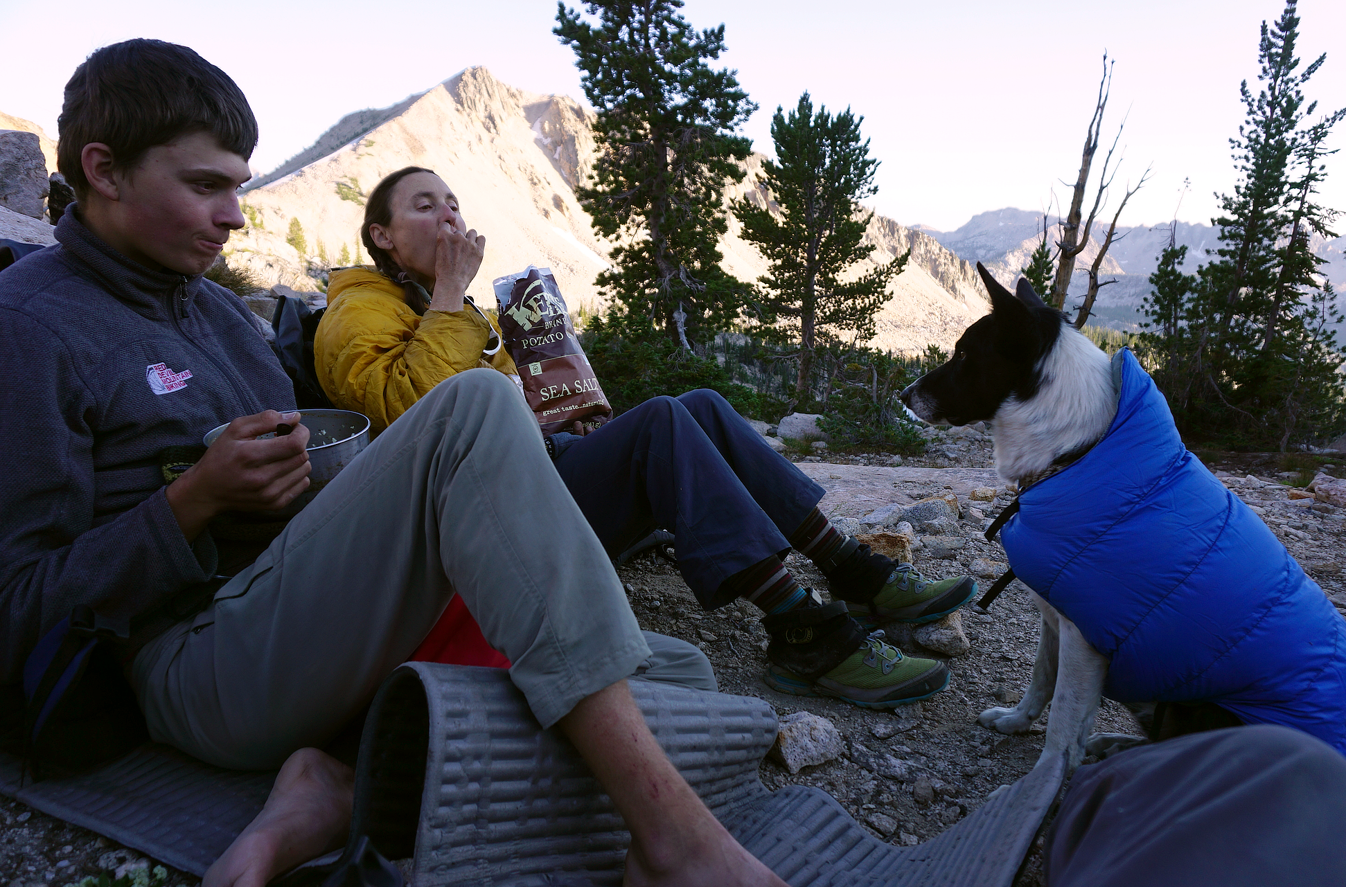 DSC05447
 DSC05552
 DSC05425
 DSC05508
 DSC05529
 DSC05593
 DSC05613
 DSC05566
 DSC05634
 DSC05668
 DSC05673
 DSC05686
 DSC05685
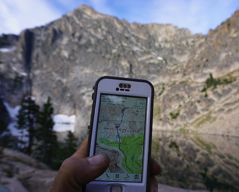 Image 8-17-16 at 09.22