- Joined
- Aug 9, 2007
- Messages
- 12,955
As my luck seems to go with these things, I failed at pulling a permit in any of the river lotteries for 2018. But it seems my lack of luck in getting my own permit is frequently replaced by the luck of my friends. That was the case for the San Juan River this year. Back in February the results were released I was saddened to find I was again denied. I sent messages to the crew urging them to check their status. It was the night before email notifications go out, but it's like Christmas. Or the opposite, usually. I can't wait to find out. A little while later I get a message from @Dave. HE WON!!! Last year he pulled a miraculous win for a Yampa permit and now the San Juan. I prepared to go to bed knowing that we finally had at least one 2018 permit for something lined up. His permit request was just for the Lower San Juan, a 54-mile stretch starting at Mexican Hat and ending at Clay Hills. The full stretch starting at Sand Island would have been nicer, but I won't complain!
As I was drifting off to sleep my phone buzzed again. I picked it up to see a message from @Jen. SHE WON TOO!!! And for the full 7-8 day trip from Sand Island! Two permits to choose from! Or maybe two trips to go on! What a problem to have! Over the following months we watched the hydrograph for the San Juan, fretting about the dismal amount of snow in the headwaters in southwest Colorado. Dave's shorter permit was for mid-May. Jen's long permit was for early June. Usually either time would be ideal with the highest flows in early June. I was leaning hard toward June but there was a problem there. Dave couldn't make that date work. We watched and waited.
Soon enough we came to the conclusion that we'd be lucky to have any water on either date. The area was in a record drought with something like 30% of average snowpack if my memory is correct. The peak flow would likely come earlier than June, if there was one. And so we opted for the safer bet in May and cancelled our other permit with plenty of time for others to pick it up and use it. The flow of the lower San Juan is regulated by releases at Navajo Dam in New Mexico. During a typical spring, it's common to expect flows in the 3-8k CFS range, depending on how much snow we had and how full the reservoirs are. During drier times, they try to keep the river at around 400-500 cfs. While flows that low are certainly doable in a loaded raft, it's not as pleasant and often involves quite a bit of getting out to drag the boat through rocks and sandbars. Especially in the last ~14 miles where Lake Powell has dropped huge amounts of silt and caused the river to meander through shallow silt bars.
As our date approached, things were looking bad. The hydrograph indicated the river was at minimum flow. Or less. At one point it came in below 400 cfs. I saw posts on Facebook indicating the effect it was having on people's trips. One read something to the effect of "We've had a bunch of people come off the San Juan lately with sore hooves, and it wasn't from hiking". They'd been dragging their boats through the miles of silt. We considered alternatives. Friends were coming from across the country so cancellation was not an option. Also, it was to be my wife's first big whitewater river trip. I did NOT want it to suck. But with less than a week before our trip, the river spiked for the first time of the year, hitting upwards of 1700 CFS. Trip on!
Here's the hydrograph for May 2018. Our dates on the river are the area highlighted in yellow. As you can see, it dipped back down a bit but we were still able to ride a decent 800-1000 cfs for the duration of the trip. The average for the same dates is closer to 4000 CFS.

The night before our launch we all met up at Muley Point for a night around the fire. The next day a few of us headed to the ramp with the boats while the others moved some cars. We were doing a paid shuttle for our main vehicles but leaving some others elsewhere to avoid paying to move 5 cars. By mid-morning we were mostly rigged and wondering where on earth the rest of the group was. It's been way too long, I thought. What happened?
11 o'clock rolled around and so did happy hour. Somewhere... Midway through my second cocktail I saw Collin's Subaru bouncing down the dirt road to the ramp. What a relief! We worked quickly to get his raft loaded and get everything else rigged up to go. We had a long day ahead of us. It would be 18 miles through the Goosenecks to to reach our target at the base of the Honaker Trail. Off we go!

Gypsum Creek Rapid, one of only a handful on the entire stretch, is quickly encountered after pushing off. It's just a class II, but it was way more interesting than I expected. No footage or photos, unfortunately, but you can see it pouring off in the distance there.

And soon after we pass under the Highway 163 bridge. The last sign of civilization we'll see for the next 5 days.

From here the canyon walls climb as the river follows a mellow gradient. Within a mile or two, we've already seen more Bighorn Sheep than most people see in years.


And the walls grow higher.


Passing through the winding bends of the Goosenecks. Audra takes a nap. I try to come up with new song parodies for our "band", The Canyon Country Groovers. Most are about the groover (river toilet), some about other aspects of river life like crushing beer cans (Yoshimi battles the pink robots was good for that). Lazy days on the river are good.

Smiles abound.

Alli took the oars on my boat for a mile or so.

Rounding the corner at Honaker had us concerned. We'd passed up some good spots and noticed people at the first spot. We pulled over and Dave ran down the bench. Good news, the best was further down, and it was empty. I did a poor job of taking photos on this trip. I only got out the big camera a few times. Most everything is with my iPhone, and I didn't even get that out very much so no camp photos that night. Dave posted some pics in this thread that will fill in some of the gaps: https://backcountrypost.com/threads/hells-half-and-honaker-spring-2018.7869/
The next day was another long one. We were front loading mileage so that we could spend more time at our two reserved campsites in the lower part of the canyon. Oar goal was a campsite at John's Canyon, another 18 or so miles down. We would see plenty of wildlife again on this day.


One of the most interesting parts of the day was a river-wide rock garden right before John's Canyon. We sent the kayak down first to help point us to the best path, but we all still got pretty stuck. Like really stuck, actually. But with a bit of bouncing, pushing and pulling in pretty deep, swift water, we were free. Yeah, I know what you're thinking, how do you get stuck in 'deep, swift' water. It's weird, but you'd probably get stuck there too.
Collin and Dave work on a fine dinner of Beef Bourguignon at John's Canyon.

Audra and I go for a walk to see the huge dryfall at the end of John's Canyon.


Lower John's Camp was empty. It had a nicer view.

The next day was shorter but we had Government Rapid to look forward to. We stopped to scout. Jen went first in the kayak.


And Nilauro in my cataraft that he rowed for the trip.

The ladies watch as I go for my run. As I get ready, a group of about 20, all women, arrive at the scout location and get out to watch as well. The pressure is on!

And then.... (photo by Collin)

Okay, that looks bad, but it really wasn't. Here's the video:
I wanted to stick around and do some laps on the kayak, but I felt like we should get out of the way and let the big group of ladies have it to themselves. From here on out the river is flat. More so as we approach Slickhorn Canyon where Lake Powell once reached, leaving a load of river-killing sediment in its wake. The landing for our campsite (Slickhorn C) was not easy to get to. At slightly lower water, we would have been on the gravel 30 feet or more from the bank. We were able to walk the boats in, crossing our fingers the river would not drop too much by morning when it was time to leave.

We spent the last sunny hours of the day swimming and hanging out in the river. It was discovered that there is one benefit to catarafts. It was also discovered on this trip that there aren't really many others...

A groover with a view. Which reminds me of one of the song snippets that we came up with on this trip. I think Dave and/or Collin started this. We didn't get far, but remember that song "Hit me with your best shot"? Here's a snippet of our version:
Please put the groover in the best spot!
I need a view to make my deuce drop!
Or the really bad ear worm... (think TLC Waterfalls)
Don't go chasing groover spots
Please stick to that nice one that we parked the boats next to
I know that you want to have a view when you're on the john
but there's no way I'm climbing up that
And of course, the Smell of Groover (Sound of Silence), which I finished writing while sitting on the beach at this campsite after dinner. The first Canyon Country Groovers song we actually completed.
Hello groover, my old friend
I’ve come to poop in you again
Because the beans that I’ve been eating
Pressure built while I was sleeping
And the gristle
that was eaten with my steak
Still remains
Within the smell
Of groover
On winding streams I poop alone
Beneath cliff walls made of sandstone
And in the light beam of my headlamp
I turned and walked south right out of camp
When my nose was stabbed by the smell of the groover box
Out by the rocks
That’s how you find
The groover
Okay, there's a lot more verses of that one, but now is not the place. This is the place:

It was Jen and Alli's night to cook dinner, so after setting up our cots, Audra and I went for a hike up Slickhorn in the evening light. It was gorgeous. A highlight of the trip.


The geology is amazing.

Taking the high route back into camp. They were getting rowdy down there.

The next day we took our time getting on the river. It was only 4 miles to our last campsite at the mouth of Grand Gulch.

Audra took the oars for a couple of miles.


Rowing a raft is like a foreign language compared to paddling a kayak. This slow flat water on this stretch was great to learn on.

We started hitting the notorious Lake Powell silt bars shortly before arriving at Grand Gulch. The current running along a ledge at the landing required some quick work, but soon enough I was looking up the canyon. We'll go up there later, I thought.

We spent several hours swimming and hanging out in the shade of the biminis. The ledge running along camp was great for jumping in and then floating back to the boats. We even did some throw line practice, but probably not enough.


It was a great campsite and an even better bocce ball course. No balls were lost in the river.")

That last night was our turn to cook. I grilled steak on the firepan grill while Audra made some sides on the stove. We all wore our Canyon Country Groovers T-shirts that I had made. It was a good night.

The next morning we were up early (but not early enough). We had 13 miles to the take out but this would prove to be the biggest challenge of the trip. The water is so muddy that you really can't tell if it's 2 inches or 2 feet deep. Picking the proper channel requires constant attention and maneuvering.

Smarter people might have picked one of the campsites further down like Oljieto or Steer Gulch. But we wanted Grand Gulch. We knew what we were in for. Well, maybe not exactly this bad. There was a good amount of boat dragging. Especially the cataraft with a novice captain and a deeper draft. The two rafts made it through without too much trouble but much time was spent waiting. Our hopes of getting home at a reasonable hour melted away at a snail's pace

But soon enough, the Clay Hills came into view and we knew we were almost there. At this rate, we could be home by 11?

The water at the take out is very shallow and muddy which made unrigging and loading harder than usual. But soon enough we were packed up and on our way.
Audra, Jen and I headed straight back while Collin made the valiant sacrifice of doing the 30 minute detour to get everyone else back to their cars at Kane Gulch. I felt bad, but I didn't have room to carry all those people. As we winded our way up North Wash I noticed someone hitchhiking on the opposite side of the road. How strange, I thought. As a whizzed by I saw his face for a half second. I couldn't believe it. It was Jamal! (@Jammer) We hopped out and ran back down the road to him to see what was up. He was on day 30 something of his big Zion to Arches hike. I'd just had lunch with him a few days before leaving so I'd been thinking about where he might be. He told us that he'd just come down off the cliffs behind him and had been trying unsuccessfully to get a ride for over an hour. He was getting ready to give up and start walking the 8 miles of pavement that he'd done before. The last thing I wanted to do was delay our arrival at home to midnight or beyond, but there was no way I was letting him do that. We turned the truck around, tossed his stuff in and drove him over the bridge to the start of the road to Dark Canyon.
Jamal's perspective of this event was well documented in his latest series of videos. I'm so psyched to finally have an appearance in one of his videos! Here's the exact spot if you haven't seen it. Watch them all!
On the drive we noticed the water in his bottle looked more like green tea. Turned out it was some nasty lake powell water he'd just spent a good amount of time filling up on. Before he left, he chugged a ton of cold spring water and we replaced his supply. We also took some unneeded items from him to pickup later and offered him any food he would take. As we sat there on the side of the road, the rest of the group came by, some stopping to say hello. I no longer felt bad giving Collin shuttle duty.

Soon enough we were on our way, and Jamal was back under foot power heading to Dark Canyon. All in all, this was an amazing trip. Looking forward to 2019 it is amongst the trips I want to do the most. Yeah, I've done it, but it's not like that with a river. There's so much we didn't see and do and so many ways to spend the days. And Audra loved it. I think a few more like this and maybe she'll be ready for Deso-level stuff. And of course I still need to do the Sand Island to Mexican Hat section. I guess it's time to put in for permits, isn't it...

As I was drifting off to sleep my phone buzzed again. I picked it up to see a message from @Jen. SHE WON TOO!!! And for the full 7-8 day trip from Sand Island! Two permits to choose from! Or maybe two trips to go on! What a problem to have! Over the following months we watched the hydrograph for the San Juan, fretting about the dismal amount of snow in the headwaters in southwest Colorado. Dave's shorter permit was for mid-May. Jen's long permit was for early June. Usually either time would be ideal with the highest flows in early June. I was leaning hard toward June but there was a problem there. Dave couldn't make that date work. We watched and waited.
Soon enough we came to the conclusion that we'd be lucky to have any water on either date. The area was in a record drought with something like 30% of average snowpack if my memory is correct. The peak flow would likely come earlier than June, if there was one. And so we opted for the safer bet in May and cancelled our other permit with plenty of time for others to pick it up and use it. The flow of the lower San Juan is regulated by releases at Navajo Dam in New Mexico. During a typical spring, it's common to expect flows in the 3-8k CFS range, depending on how much snow we had and how full the reservoirs are. During drier times, they try to keep the river at around 400-500 cfs. While flows that low are certainly doable in a loaded raft, it's not as pleasant and often involves quite a bit of getting out to drag the boat through rocks and sandbars. Especially in the last ~14 miles where Lake Powell has dropped huge amounts of silt and caused the river to meander through shallow silt bars.
As our date approached, things were looking bad. The hydrograph indicated the river was at minimum flow. Or less. At one point it came in below 400 cfs. I saw posts on Facebook indicating the effect it was having on people's trips. One read something to the effect of "We've had a bunch of people come off the San Juan lately with sore hooves, and it wasn't from hiking". They'd been dragging their boats through the miles of silt. We considered alternatives. Friends were coming from across the country so cancellation was not an option. Also, it was to be my wife's first big whitewater river trip. I did NOT want it to suck. But with less than a week before our trip, the river spiked for the first time of the year, hitting upwards of 1700 CFS. Trip on!
Here's the hydrograph for May 2018. Our dates on the river are the area highlighted in yellow. As you can see, it dipped back down a bit but we were still able to ride a decent 800-1000 cfs for the duration of the trip. The average for the same dates is closer to 4000 CFS.
The night before our launch we all met up at Muley Point for a night around the fire. The next day a few of us headed to the ramp with the boats while the others moved some cars. We were doing a paid shuttle for our main vehicles but leaving some others elsewhere to avoid paying to move 5 cars. By mid-morning we were mostly rigged and wondering where on earth the rest of the group was. It's been way too long, I thought. What happened?
11 o'clock rolled around and so did happy hour. Somewhere... Midway through my second cocktail I saw Collin's Subaru bouncing down the dirt road to the ramp. What a relief! We worked quickly to get his raft loaded and get everything else rigged up to go. We had a long day ahead of us. It would be 18 miles through the Goosenecks to to reach our target at the base of the Honaker Trail. Off we go!
Gypsum Creek Rapid, one of only a handful on the entire stretch, is quickly encountered after pushing off. It's just a class II, but it was way more interesting than I expected. No footage or photos, unfortunately, but you can see it pouring off in the distance there.
And soon after we pass under the Highway 163 bridge. The last sign of civilization we'll see for the next 5 days.
From here the canyon walls climb as the river follows a mellow gradient. Within a mile or two, we've already seen more Bighorn Sheep than most people see in years.
And the walls grow higher.
Passing through the winding bends of the Goosenecks. Audra takes a nap. I try to come up with new song parodies for our "band", The Canyon Country Groovers. Most are about the groover (river toilet), some about other aspects of river life like crushing beer cans (Yoshimi battles the pink robots was good for that). Lazy days on the river are good.
Smiles abound.
Alli took the oars on my boat for a mile or so.
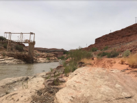
Rounding the corner at Honaker had us concerned. We'd passed up some good spots and noticed people at the first spot. We pulled over and Dave ran down the bench. Good news, the best was further down, and it was empty. I did a poor job of taking photos on this trip. I only got out the big camera a few times. Most everything is with my iPhone, and I didn't even get that out very much so no camp photos that night. Dave posted some pics in this thread that will fill in some of the gaps: https://backcountrypost.com/threads/hells-half-and-honaker-spring-2018.7869/
The next day was another long one. We were front loading mileage so that we could spend more time at our two reserved campsites in the lower part of the canyon. Oar goal was a campsite at John's Canyon, another 18 or so miles down. We would see plenty of wildlife again on this day.
One of the most interesting parts of the day was a river-wide rock garden right before John's Canyon. We sent the kayak down first to help point us to the best path, but we all still got pretty stuck. Like really stuck, actually. But with a bit of bouncing, pushing and pulling in pretty deep, swift water, we were free. Yeah, I know what you're thinking, how do you get stuck in 'deep, swift' water. It's weird, but you'd probably get stuck there too.
Collin and Dave work on a fine dinner of Beef Bourguignon at John's Canyon.
Audra and I go for a walk to see the huge dryfall at the end of John's Canyon.
Lower John's Camp was empty. It had a nicer view.
The next day was shorter but we had Government Rapid to look forward to. We stopped to scout. Jen went first in the kayak.
And Nilauro in my cataraft that he rowed for the trip.
The ladies watch as I go for my run. As I get ready, a group of about 20, all women, arrive at the scout location and get out to watch as well. The pressure is on!
And then.... (photo by Collin)
Okay, that looks bad, but it really wasn't. Here's the video:
I wanted to stick around and do some laps on the kayak, but I felt like we should get out of the way and let the big group of ladies have it to themselves. From here on out the river is flat. More so as we approach Slickhorn Canyon where Lake Powell once reached, leaving a load of river-killing sediment in its wake. The landing for our campsite (Slickhorn C) was not easy to get to. At slightly lower water, we would have been on the gravel 30 feet or more from the bank. We were able to walk the boats in, crossing our fingers the river would not drop too much by morning when it was time to leave.
We spent the last sunny hours of the day swimming and hanging out in the river. It was discovered that there is one benefit to catarafts. It was also discovered on this trip that there aren't really many others...
A groover with a view. Which reminds me of one of the song snippets that we came up with on this trip. I think Dave and/or Collin started this. We didn't get far, but remember that song "Hit me with your best shot"? Here's a snippet of our version:
Please put the groover in the best spot!
I need a view to make my deuce drop!
Or the really bad ear worm... (think TLC Waterfalls)
Don't go chasing groover spots
Please stick to that nice one that we parked the boats next to
I know that you want to have a view when you're on the john
but there's no way I'm climbing up that
And of course, the Smell of Groover (Sound of Silence), which I finished writing while sitting on the beach at this campsite after dinner. The first Canyon Country Groovers song we actually completed.
Hello groover, my old friend
I’ve come to poop in you again
Because the beans that I’ve been eating
Pressure built while I was sleeping
And the gristle
that was eaten with my steak
Still remains
Within the smell
Of groover
On winding streams I poop alone
Beneath cliff walls made of sandstone
And in the light beam of my headlamp
I turned and walked south right out of camp
When my nose was stabbed by the smell of the groover box
Out by the rocks
That’s how you find
The groover
Okay, there's a lot more verses of that one, but now is not the place. This is the place:
It was Jen and Alli's night to cook dinner, so after setting up our cots, Audra and I went for a hike up Slickhorn in the evening light. It was gorgeous. A highlight of the trip.
The geology is amazing.
Taking the high route back into camp. They were getting rowdy down there.
The next day we took our time getting on the river. It was only 4 miles to our last campsite at the mouth of Grand Gulch.
Audra took the oars for a couple of miles.
Rowing a raft is like a foreign language compared to paddling a kayak. This slow flat water on this stretch was great to learn on.
We started hitting the notorious Lake Powell silt bars shortly before arriving at Grand Gulch. The current running along a ledge at the landing required some quick work, but soon enough I was looking up the canyon. We'll go up there later, I thought.
We spent several hours swimming and hanging out in the shade of the biminis. The ledge running along camp was great for jumping in and then floating back to the boats. We even did some throw line practice, but probably not enough.
It was a great campsite and an even better bocce ball course. No balls were lost in the river.
That last night was our turn to cook. I grilled steak on the firepan grill while Audra made some sides on the stove. We all wore our Canyon Country Groovers T-shirts that I had made. It was a good night.
The next morning we were up early (but not early enough). We had 13 miles to the take out but this would prove to be the biggest challenge of the trip. The water is so muddy that you really can't tell if it's 2 inches or 2 feet deep. Picking the proper channel requires constant attention and maneuvering.
Smarter people might have picked one of the campsites further down like Oljieto or Steer Gulch. But we wanted Grand Gulch. We knew what we were in for. Well, maybe not exactly this bad. There was a good amount of boat dragging. Especially the cataraft with a novice captain and a deeper draft. The two rafts made it through without too much trouble but much time was spent waiting. Our hopes of getting home at a reasonable hour melted away at a snail's pace
But soon enough, the Clay Hills came into view and we knew we were almost there. At this rate, we could be home by 11?
The water at the take out is very shallow and muddy which made unrigging and loading harder than usual. But soon enough we were packed up and on our way.
Audra, Jen and I headed straight back while Collin made the valiant sacrifice of doing the 30 minute detour to get everyone else back to their cars at Kane Gulch. I felt bad, but I didn't have room to carry all those people. As we winded our way up North Wash I noticed someone hitchhiking on the opposite side of the road. How strange, I thought. As a whizzed by I saw his face for a half second. I couldn't believe it. It was Jamal! (@Jammer) We hopped out and ran back down the road to him to see what was up. He was on day 30 something of his big Zion to Arches hike. I'd just had lunch with him a few days before leaving so I'd been thinking about where he might be. He told us that he'd just come down off the cliffs behind him and had been trying unsuccessfully to get a ride for over an hour. He was getting ready to give up and start walking the 8 miles of pavement that he'd done before. The last thing I wanted to do was delay our arrival at home to midnight or beyond, but there was no way I was letting him do that. We turned the truck around, tossed his stuff in and drove him over the bridge to the start of the road to Dark Canyon.
Jamal's perspective of this event was well documented in his latest series of videos. I'm so psyched to finally have an appearance in one of his videos! Here's the exact spot if you haven't seen it. Watch them all!
On the drive we noticed the water in his bottle looked more like green tea. Turned out it was some nasty lake powell water he'd just spent a good amount of time filling up on. Before he left, he chugged a ton of cold spring water and we replaced his supply. We also took some unneeded items from him to pickup later and offered him any food he would take. As we sat there on the side of the road, the rest of the group came by, some stopping to say hello. I no longer felt bad giving Collin shuttle duty.
Soon enough we were on our way, and Jamal was back under foot power heading to Dark Canyon. All in all, this was an amazing trip. Looking forward to 2019 it is amongst the trips I want to do the most. Yeah, I've done it, but it's not like that with a river. There's so much we didn't see and do and so many ways to spend the days. And Audra loved it. I think a few more like this and maybe she'll be ready for Deso-level stuff. And of course I still need to do the Sand Island to Mexican Hat section. I guess it's time to put in for permits, isn't it...
Last edited: