The Plug exit of Pictograph Fork (Maze)

RyanP

Member
Joined
Mar 1, 2015
Messages
578
I'm considering doing a route in the Maze that includes the exit at the Plug from Pictograph Fork. I've done several of the other exits in the Maze (Shot Canyon, Pete's Mesa Route, SE Branch of Picto Fork, Sweet Alice to Standing Rock, etc.), but my impression is that the Plug exit may be more difficult than those, and I don't want to do anything much harder than those for this trip because it will be my son's first trip to the Maze. If anyone here has done both the Plug exit as well as some of the others, can you please comment on how hard it is relative to the others?

Thanks!
Ryan
 
I think I once asked a ranger if that exit was spicier than the SE Branch, and she said yes. Sorry, that's all I got. Next time, I'll explore Horse all the way south from the Overlook area because I think it has water and a gentle exit, then walk East past the Plug.
 
I think I once asked a ranger if that exit was spicier than the SE Branch, and she said yes. Sorry, that's all I got. Next time, I'll explore Horse all the way south from the Overlook area because I think it has water and a gentle exit, then walk East past the Plug.
Thanks @futurafree. Yeah, that's the kind of hearsay that I've heard before about the Plug (I've heard/read other people saying they heard that it's spicier than the other exits, but I haven't heard a direct comparison from anyone who has done both). @R@nger, @TrailScot, @Nick, @IntrepidXJ: any input is appreciated!

Edit: I had posted this question on Randy's blog (@IntrepidXJ), and just noticed he answered with the following: "I didn’t find The Plug exit any more difficult than any other routes in the Maze. It seemed pretty standard for the area and I didn’t find it difficult at all, other than me being tired at the end of a long hike that day." Thanks Randy!
 
While on a trip in the Maze, we talked to a ranger by the Harvest Scene that said that the Plug exit was more difficult than the exit up to Chimney rock, so we ended up taking the latter. The exit up toward Chimney Rock wasn't crazy hard but was not a cake walk either. I thought it was fun myself. If I ever make it back to the Maze I'd be curious to try the Plug exit just to see how it is.
 
The exit up toward Chimney Rock wasn't crazy hard but was not a cake walk either. I thought it was fun myself.
Agreed on all accounts. Which is why I want to try the plug next time, but not if it's significantly harder (but Randy didn't think it was).
 
Last edited:
NPS Ranger here - sorry, late to the party. Hope you and your son enjoyed the trip Ryan, I think I checked your permit in the backcountry if I remember right. Hopefully somebody will find this useful.

I'd say that the Plug Route is a little tougher, as it wasn't an improved stock trail (Chimney Rock was, once upon a time). Some steep angles where you'll likely have to crawl up or slide down slickrock. Some folks bring rope if they're backpacking - which as a side note, is never a bad thing to bring in the Maze. And obviously the Plug Route is longer, so more sand slogging through the canyons. But in my opinion, they're comparable. If you can do the Chimney Rock loop, you can do the Plug Route.
Thanks R@nger! We haven't done the trip yet; we're planning on going during my son's Spring Break (late March) if the weather permits. Yeah, I always bring a rope or cord to help with pack hauling/lowering when I'm somewhere like the Maze. One more question for you: how is the water availability in the South Fork Horse Canyon? Our plan for the first day is to drive my Outback however far I can from Hite (probably to around the Waterhole Flat area), then ride our bikes for a handful of miles to the South Fork Horse Canyon entrance, then drop into the canyon and hike down the canyon and find somewhere to camp, hopefully near water (then we'll spend the next couple of days wandering the other canyons of the Maze, and finish by exiting at the Plug). Do you know if there is reliable water in that canyon? Even if there is reliable or semi-reliable water, I will still carry enough water for us to backtrack safely if we don't find any.
 
Thanks R@nger! We haven't done the trip yet; we're planning on going during my son's Spring Break (late March) if the weather permits. Yeah, I always bring a rope or cord to help with pack hauling/lowering when I'm somewhere like the Maze. One more question for you: how is the water availability in the South Fork Horse Canyon? Our plan for the first day is to drive my Outback however far I can from Hite (probably to around the Waterhole Flat area), then ride our bikes for a handful of miles to the South Fork Horse Canyon entrance, then drop into the canyon and hike down the canyon and find somewhere to camp, hopefully near water (then we'll spend the next couple of days wandering the other canyons of the Maze, and finish by exiting at the Plug). Do you know if there is reliable water in that canyon? Even if there is reliable or semi-reliable water, I will still carry enough water for us to backtrack safely if we don't find any.
Copy that! I confused you with somebody else I met this last fall; they also brought their son to that area for the first time.

Water in South Fork is generally reliable, particularly that time of year. There's a solid water source roughly 2 miles in from the trailhead. Glad to see you have a backup plan too. You can also fill up at Lou's Spring - it was troughed up in 1934. Very clean water and a neat place to see if you haven't been. Once you're in the canyons north of the Land of Standing Rocks, the strongest spring will probably be at the base of Maze Overlook.

And as a side note with parking, there's a good place to park in Waterhole Flat just before the road gets rough - somebody at Hans Flat could give you the beta on that when you call to get the permit issued. Also keep in mind that you'll have to park your bikes at the trailhead parking or a ranger might give you a hard time. We've never had a visitor take off with somebody's stuff out here, but something to consider.

I'll be back from my furlough come mid-March, so maybe I'll run into you out there. Let me know if you have any other questions!
 
Last edited:
Copy that! I confused you with somebody else I met this last fall; they also brought their son to that area for the first time.

Water in South Fork is generally reliable, particularly that time of year. There's a solid water source roughly 2 miles in from the trailhead. Glad to see you have a backup plan too. You can also fill up at Lou's Spring - it was troughed up in 1934. Very clean water and a neat place to see if you haven't been. Once you're in the canyons north of the Land of Standing Rocks, the strongest spring will probably be at the base of Maze Overlook.

And as a side note with parking, there's a good place to park in Waterhole Flat just before the road gets rough - somebody at Hans Flat could give you the beta on that when you call to get the permit issued. Also keep in mind that you'll have to park your bikes at the trailhead parking or a ranger might give you a hard time. We've never had a visitor take off with somebody's stuff out here, but something to consider.

I'll be back from my furlough come mid-March, so maybe I'll run into you out there. Let me know if you have any other questions!
This is great info (particularly about the water source 2 miles up); thanks so much! I think our itinerary will be to get to that water source on Day 1 (the majority of the day will be driving/biking), then hike down to the Spring below the Maze Overlook on Day 2 and do a side trip scrambling attempt up to the overlook (that may be outside of our comfort zones, but we can at least see how far we're comfortable with it--we won't have the heavy packs for that part at least). Then on Day 3 we'll do a day-hike without the heavy packs, looping down the SE fork of Picto Canyon and back via Jasper Ridge, then on Day 4 we'll return via the Plug. My impression is that the Maze Overlook is a tougher scramble than any of the other main canyon exits there (I've never done it before); is that correct in your opinion? If we can handle those other ascents/descents with the packs, do you think we'd probably be up for the Maze Overlook without the packs?
 
This is great info (particularly about the water source 2 miles up); thanks so much! I think our itinerary will be to get to that water source on Day 1 (the majority of the day will be driving/biking), then hike down to the Spring below the Maze Overlook on Day 2 and do a side trip scrambling attempt up to the overlook (that may be outside of our comfort zones, but we can at least see how far we're comfortable with it--we won't have the heavy packs for that part at least). Then on Day 3 we'll do a day-hike without the heavy packs, looping down the SE fork of Picto Canyon and back via Jasper Ridge, then on Day 4 we'll return via the Plug. My impression is that the Maze Overlook is a tougher scramble than any of the other main canyon exits there (I've never done it before); is that correct in your opinion? If we can handle those other ascents/descents with the packs, do you think we'd probably be up for the Maze Overlook without the packs?
Glad this is helpful man! That sounds like an awesome itinerary - you'll get to hike most all of the advertised routes in South/Picto Forks, which is a real treat.
I'd agree that the Maze Overlook route is the toughest of the main exits, and a bit of a scramble. There's some steep upclimbs and obstacles that make it interesting. Good news is, all of the tough stuff is in the first 1/4 mile or so coming out of the canyon. Once you're in the upper levels of the Cedar Mesa Formation it gets much easier. It's also easier going up than down because you can see the hand and footholds. I'm willing to bet that if you can handle those other trails while carrying heavy packs, you'll do just fine on the Maze Overlook route.
 
Hi Ryan. This sounds like a great trip you and your son will always remember! A few thoughts that I have- some that have already been answered but thought I'd add my 2 cents..ha ha

- That is a pretty long bike ride in from waterhole- I'd guess approx 15 miles, or is it by motorcycle. Are you coming in from the south already?
- Going out the Plug will be no problem since you already have experience with other entry/exits in the maze. I wouldn't sweat that at all.
- South Fork Horse Canyon doesn't get the traffic as the rest of maze proper- I think you'll really enjoy that section. It has a little more wild feel than Picto/Petes trails, especially in March.

- My 2 personal favorite descents are the overlook trail and golden stairs, I wouldn't pass it up if you are right there.
-I would definitely day hike up the overlook trail to brimhall point. Its really a fun section of trail- your son will love it! There is one short Chute that you can bypass by going around that at first glance looks daunting (its pretty obvious but some people can miss it). Plenty of great spots for lunch up on top, even over by the designated camp sites. Plus Great pictures of the choc drops with the maze in the background. That view is awesome, and pointing out chimney rock way off in the distance and saying we will be there tomorrow is always fun with the labrynth below!

Hope you have a great trip with your son!

I will miss you by a week- Ill be down in there March 5th-8th to take a friend who hasn't been there before.

Also- you will be passing right by a nice harvest scene like attraction on your drive in. Approx 5 miles hiking off the main road. If your interested I can PM you
 
Last edited:
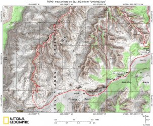
What's the Plug exit? I ask since the Plug is over by the headwater forks of Picto Fork, is it not? I take it it is not this:S Fk Exut.JPG
 
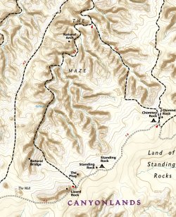
Hi John- you can exit picto to the chimney rock road by heading south in picto and staying in the west fork and climbing out right by the natural bridge label on your map. The trails illustrated map has the route marked on it. Thats cool your map has the old road to the dollhouse on !!
 
Nat Geo trails illustrated map shows the Plug exit we're speaking of.

Screenshot_20230119_210731_Gaia GPS.jpg
 
Last edited:
Hi Ryan. This sounds like a great trip you and your son will always remember! A few thoughts that I have- some that have already been answered but thought I'd add my 2 cents..ha ha

- That is a pretty long bike ride in from waterhole- I'd guess approx 15 miles, or is it by motorcycle. Are you coming in from the south already?
- Going out the Plug will be no problem since you already have experience with other entry/exits in the maze. I wouldn't sweat that at all.
- South Fork Horse Canyon doesn't get the traffic as the rest of maze proper- I think you'll really enjoy that section. It has a little more wild feel than Picto/Petes trails, especially in March.

- My 2 personal favorite descents are the overlook trail and golden stairs, I wouldn't pass it up if you are right there.
-I would definitely day hike up the overlook trail to brimhall point. Its really a fun section of trail- your son will love it! There is one short Chute that you can bypass by going around that at first glance looks daunting (its pretty obvious but some people can miss it). Plenty of great spots for lunch up on top, even over by the designated camp sites. Plus Great pictures of the choc drops with the maze in the background. That view is awesome, and pointing out chimney rock way off in the distance and saying we will be there tomorrow is always fun with the labrynth below!

Hope you have a great trip with your son!

I will miss you by a week- Ill be down in there March 5th-8th to take a friend who hasn't been there before.

Also- you will be passing right by a nice harvest scene like attraction on your drive in. Approx 5 miles hiking off the main road. If your interested I can PM you
Thanks for all the info Cody! Yeah, it's not a short bike ride... but it's not terribly long either. I expect it will take a good chunk of Day 1, since we'll be taking it slowly and carefully. But we have very little hiking mileage that day so we should be fine. I actually think the most dangerous part of the trip is probably riding the bikes with all the weight--we're both mountain bikers, but we're not used to biking with extra weight, and that will probably throw off the handling a lot. A few years ago I rode my bike down the Flint trail switchbacks and it was actually kind of sketchy with all that weight (I think it may have been the most dangerous part of that trip!).

I probably wouldn't sweat the plug exit if I were just going by myself, but since it's my son's first time, and that would be on our way on the last day, I didn't want to get in over our heads... but from multiple people's input here, it sounds like it shouldn't be a big problem.

Thanks for the tip about the Chute you can bypass on the overlook trail. I'll keep an eye out for it. Also, if you're willing to PM me some details about that destination off the main road, I'm definitely interested (and will not ever divulge it publicly).
 

Similar threads

Back
Top