- Joined
- Aug 18, 2018
- Messages
- 1,768
From the all white rim you enjoy endless miles with dramatic views of the Strike Valley, the Henry Mountains and the colorful Waterpocket Fold itself. And if you turn the head slightly, you have incredible views of the narrow red canyon flanked by countless red arches and unusual eroded and twisted red sandstone formations. It's truly a special place, but it's difficult to get to.
Here is the view from the white rim, notice the snow on the Henry Mountains

Here is another view- just by turning your head the other way! Notice all the arches along the canyon

Our plan was to camp close by the TH, just off Burr trail rd (but outside the Capitol Reef NP), get an early start on a Sunday in late October and drive the 3 miles into the wash / access road requiring high clearance and 4-wheel drive. Needless to say we didn't need rain before or during the drive. Especially since the access road is fairly remote and located just off the top of the Burr Trail rd switchbacks in Capitol Reef NP.
On Friday (2 days before the planned hike) we woke up to a sunny and warm weather forecast, but the forecast for Sunday was cloudy with a 20% chance of rain. Hm…. that was 80% of no rain, but we changed plans and headed out the door around 8 am from Torrey, which is about 2 hours from the high clearance access road / dry wash to the trailhead. So, no early start.... But we made great (!) time on the dry Notom-Bullfrog (mostly dirt rd) and we had amazing morning views of the Waterpocket Fold. We chose the dirt road approach, because it was slow going with icy and snowy conditions over the mountains to Boulder, just a few days prior. The same evening we had driven the Notom-Bullfrog rd and it was a smooth ride on the dry dirt road.
We arrived at the switchbacks for the second time that week. The switchbacks cut straight through the Waterpocket Fold and the morning views were spectacular from the bottom and from the top, but by then it was almost 10am.
This was our view of the Waterpocket Fold, just before Burr trail rd:

This is on Burr trail looking at the cut through the Waterpocket Fold:

Here are the famous Burr trail rd switchbacks, just beautiful. The Henry mountains are in the background.

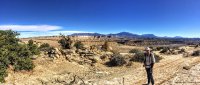
This is Rick taking photos, by now it was probably 10am!

Did I mention this was out first off road experience? It was hm....interesting. Not a low clearance road (wash), but it was a good first start. It takes time, a lot of time, to switch mentally from driving Subaru WRX with 5-6" clearance to a HC-4WD. The initial approach (not in this picture) was steep and we saw trucks parked at the 2WD Parking lot on other days. It's a 16-17 mile hike if you don't have HC.

This was our view of a beautiful arch just off the access road

Finally- off we went into Upper Muley Twist canyon on foot for the 10 mile hike. Here is Rick. Notice the gorgeous fall colors:

I believe it's about 1.8 miles of walking in the wash (after the Upper Muley twist HC/4WD TH) before the loop started. The views in the wash didn't disappoint. Look at the tafoni and beautiful rock formations.


Here is a close up view:

And then the views suddenly started to open up. Look at the cloud formations lined up in the same direction as the rocks. Lots of boulders in the wash at this location:

Closer view, impressive already

Shortly after we had to make a decision.... We arrived at the beginning of the loop and we started it counterclockwise to get the steep scramble up to the white rim out of the way first. I decided to not fully read the hike description, because I had already seen something about 'steep exposures'. It generally works out better if I just deal with it when we get there.... This is the view back towards the red side of the canyon, notice the beautiful arch- one of many we would see that day.

This is Rick on his way up to the white rim. I was looking at it from below, wondering if it would be like that hog back between Boulder and Escalante.

A little bit further up we really got the best view of Upper Muley Twist canyon itself. Spectacular, but it was about to get better.

After scrambling up and following cairns up the steep slope, we arrived to this view!
And shortly after we saw this view when we just turned our heads slightly.... Notice the arches.


We kept following the cairns along the white rim. It was pretty warm and it would be brutal in the summer here.


On occasion we had full view of the red side of the canyon with all the arches. The clouds were amazing too!
I don't think we walked very fast, the views were incredible- in all directions. This went on for a couple of miles. We encountered some very steep and exposed sections. We didn't take pictures of that. I tried not to think about it too much and I managed to scramble up or down it. Every week it gets better.


I thought I uploaded the picture with the sign of the return to the canyon. It might have been too big of a file. Anyway.... At some point we scrambled down to the bottom of the canyon.


We arrived to some awesome looking red slick rock and I quickly took off towards some slot canyon looking formations. I love that stuff. Suddenly I realized there were no cairns (probably kind of like @Ugly 's son on that backpacking trip). There was a moment of well, we are just walking out in the wash, so we don't need them. It was 3 pm or so and suddenly I remembered.... I didn't read the "memo" in my pocket. There was a bypass of a slot canyon, more scrambling was required, it wasn't just a matter of walking out of there. Here is a picture after we found the bypass route, it's just to the left of the big red Boulder, also called the red egg @Ugly wrote later.

I enjoyed these rock formations tremendously on this hike, all twisted red formations, beautiful. We scrambled for about 3/4 mile I would guess before we arrived down into the canyon again. (Since I'm having a very difficult time inserting text in between the photos on this old iPad, I'm skipping some text now....)


We eventually made it down into the wash and quickly noticed a large arch. We kept seeing wonderful formations on the way out through the wash.


Above photo is the arch we initially saw when we arrived at the loop part of the hike. The rest was the same 1.8 miles that we hiked to arrive at the loop of this hike. But notice the amazing tafoni and beautiful lit up rocks.


We returned to the Jeep and started the interesting ride back. We met nobody all day on upper Muley twist hike. But I expected we would pick up a couple of people hiking out from Strike Valley Overlook. Sure enough, we soon met two guys from Colorado. We said, would you like a ride back? Sure, they said! So we reorganized stuff in the Jeep and they jumped in. That was great company and also a great distraction to the off road driving. It was first later on I said, hm.... This is our first off road experience! You might be walking back, but we were fine. We said goodbye to them and headed (for the second time that week) back in the dark to Torrey! We have since been on much worse roads for sure.
It was a spectacular day and even though it's very difficult to write these TR on an iPad while traveling, I wanted to make sure @Perry had something to read tonight!
Here is the view from the white rim, notice the snow on the Henry Mountains
Here is another view- just by turning your head the other way! Notice all the arches along the canyon
Our plan was to camp close by the TH, just off Burr trail rd (but outside the Capitol Reef NP), get an early start on a Sunday in late October and drive the 3 miles into the wash / access road requiring high clearance and 4-wheel drive. Needless to say we didn't need rain before or during the drive. Especially since the access road is fairly remote and located just off the top of the Burr Trail rd switchbacks in Capitol Reef NP.
On Friday (2 days before the planned hike) we woke up to a sunny and warm weather forecast, but the forecast for Sunday was cloudy with a 20% chance of rain. Hm…. that was 80% of no rain, but we changed plans and headed out the door around 8 am from Torrey, which is about 2 hours from the high clearance access road / dry wash to the trailhead. So, no early start.... But we made great (!) time on the dry Notom-Bullfrog (mostly dirt rd) and we had amazing morning views of the Waterpocket Fold. We chose the dirt road approach, because it was slow going with icy and snowy conditions over the mountains to Boulder, just a few days prior. The same evening we had driven the Notom-Bullfrog rd and it was a smooth ride on the dry dirt road.
We arrived at the switchbacks for the second time that week. The switchbacks cut straight through the Waterpocket Fold and the morning views were spectacular from the bottom and from the top, but by then it was almost 10am.
This was our view of the Waterpocket Fold, just before Burr trail rd:
This is on Burr trail looking at the cut through the Waterpocket Fold:
Here are the famous Burr trail rd switchbacks, just beautiful. The Henry mountains are in the background.
This is Rick taking photos, by now it was probably 10am!
Did I mention this was out first off road experience? It was hm....interesting. Not a low clearance road (wash), but it was a good first start. It takes time, a lot of time, to switch mentally from driving Subaru WRX with 5-6" clearance to a HC-4WD. The initial approach (not in this picture) was steep and we saw trucks parked at the 2WD Parking lot on other days. It's a 16-17 mile hike if you don't have HC.
This was our view of a beautiful arch just off the access road
Finally- off we went into Upper Muley Twist canyon on foot for the 10 mile hike. Here is Rick. Notice the gorgeous fall colors:
I believe it's about 1.8 miles of walking in the wash (after the Upper Muley twist HC/4WD TH) before the loop started. The views in the wash didn't disappoint. Look at the tafoni and beautiful rock formations.
Here is a close up view:
And then the views suddenly started to open up. Look at the cloud formations lined up in the same direction as the rocks. Lots of boulders in the wash at this location:
Closer view, impressive already
Shortly after we had to make a decision.... We arrived at the beginning of the loop and we started it counterclockwise to get the steep scramble up to the white rim out of the way first. I decided to not fully read the hike description, because I had already seen something about 'steep exposures'. It generally works out better if I just deal with it when we get there.... This is the view back towards the red side of the canyon, notice the beautiful arch- one of many we would see that day.
This is Rick on his way up to the white rim. I was looking at it from below, wondering if it would be like that hog back between Boulder and Escalante.
A little bit further up we really got the best view of Upper Muley Twist canyon itself. Spectacular, but it was about to get better.
After scrambling up and following cairns up the steep slope, we arrived to this view!
And shortly after we saw this view when we just turned our heads slightly.... Notice the arches.
We kept following the cairns along the white rim. It was pretty warm and it would be brutal in the summer here.
On occasion we had full view of the red side of the canyon with all the arches. The clouds were amazing too!
I don't think we walked very fast, the views were incredible- in all directions. This went on for a couple of miles. We encountered some very steep and exposed sections. We didn't take pictures of that. I tried not to think about it too much and I managed to scramble up or down it. Every week it gets better.
I thought I uploaded the picture with the sign of the return to the canyon. It might have been too big of a file. Anyway.... At some point we scrambled down to the bottom of the canyon.
We arrived to some awesome looking red slick rock and I quickly took off towards some slot canyon looking formations. I love that stuff. Suddenly I realized there were no cairns (probably kind of like @Ugly 's son on that backpacking trip). There was a moment of well, we are just walking out in the wash, so we don't need them. It was 3 pm or so and suddenly I remembered.... I didn't read the "memo" in my pocket. There was a bypass of a slot canyon, more scrambling was required, it wasn't just a matter of walking out of there. Here is a picture after we found the bypass route, it's just to the left of the big red Boulder, also called the red egg @Ugly wrote later.
I enjoyed these rock formations tremendously on this hike, all twisted red formations, beautiful. We scrambled for about 3/4 mile I would guess before we arrived down into the canyon again. (Since I'm having a very difficult time inserting text in between the photos on this old iPad, I'm skipping some text now....)
We eventually made it down into the wash and quickly noticed a large arch. We kept seeing wonderful formations on the way out through the wash.
Above photo is the arch we initially saw when we arrived at the loop part of the hike. The rest was the same 1.8 miles that we hiked to arrive at the loop of this hike. But notice the amazing tafoni and beautiful lit up rocks.
We returned to the Jeep and started the interesting ride back. We met nobody all day on upper Muley twist hike. But I expected we would pick up a couple of people hiking out from Strike Valley Overlook. Sure enough, we soon met two guys from Colorado. We said, would you like a ride back? Sure, they said! So we reorganized stuff in the Jeep and they jumped in. That was great company and also a great distraction to the off road driving. It was first later on I said, hm.... This is our first off road experience! You might be walking back, but we were fine. We said goodbye to them and headed (for the second time that week) back in the dark to Torrey! We have since been on much worse roads for sure.
It was a spectacular day and even though it's very difficult to write these TR on an iPad while traveling, I wanted to make sure @Perry had something to read tonight!
Attachments
Last edited: