- Joined
- Apr 20, 2013
- Messages
- 1,461
As has been the case for many years, the weekend of Thanksgiving has included the outdoors. I have had good and bad, including sleet going up Grandeur, getting blown off Ennis Peak after a 430am start, etc... My more enjoyable excursions have involved heading to the desert. Mind you, it is the Cold November Desert with interminable nights.
I have not posted trip reports of past years, since there are some good places for rim and desert wandering in solitude, they are best unposted.
For me, the trick is going places where you are in full sun in the winter, where other times of the year I would melt or die of heat exhaustion.
After reaching the boat-navigable end of the Lake in September, the idea for this trip came about to travel south and see it from above. I had walked a small portion of this previously on another trip, and the airy drops, cliffs and abandoned meanders called me more than anything else.
Plus, I knew once I turned south I would be splendidly alone.
You might think that being alone, I would have thought philosophical thoughts and introspection... Hahaha, nope. Maybe I need to go alone for like a week, instead of 4 days... or maybe I am too easily distracted or shallow.
All I know is that everyone around me on this trip laughed at ALL of my jokes.
I did not go as far south as I had wanted. I spent too much time exploring along the rim.
My plans changed and I became less focused on finding the actual end of the Lake from above. I would have gotten there, if I would have followed my original plan of staying high and making a bee line to a place farther south, exploring farther south the next day, and then wandering back to the truck.
But instead I just wandered from the beginning.
With the days being short, and wanting to spend some time each day basking like a lizard to try and cure some of the winter blues, I also kept my distances short.
Which is fine by me.
I take fewer risks when I am alone, and avoided anything too steep, minus one place where I was stubborn on the side of a steep dome. I had to spread eagle to get across a drop instead of going down and back up again. Not the brightest and those are the decisions that can spiral into situations.
Oh wait! I also straddled a large crack on the rim's edge that dropped off a good 30' or more, and was only a couple feet wide (not The Crack, but another one). Besides all the time spent on the edge of the rim, that was about as much extra risk as I took.
There were a few ravens, birds, and lizards for company.
The last day I finally found a few cattle.
I saw tracks of small rodents, rabbits, bobcats, deer, and larger, more splayed hoof tracks, which I would think were bighorn sheep, but I did not see any other mammals.
It was not until the last half mile climbing to the trailhead where I scared up a couple jackrabbits.
Water was a non-issue, even though I only collected once. Finding water in perched places where the cattle do not go is usually my plan of attack. There were some potholes where I expected there to be water, and they were dry, others that I did not expect actually had water, and some were just as I had hoped. Some were frozen solid in the shade.
That's just how it goes with water.
This time I had started with 3 liters and it was about perfect for the first couple days.
I ended up not cooking, even though I had planned on some turkey tonkatsu ramen.
Thanksgiving.
After waking up early and smoking a turkey for the family lunch, I had a double serving of pie (banana cream, chocolate and berry), and then I hit the road south.
In the twilight, I narrowly avoided a big doe on the freeway near Mona, and then had a half dozen deer run across highway 20 as I climbed over into Panguitch, but no elk and no other close calls.
Escalante was a dark ghost town, so I topped off the tank and continued on. Plus it was in the 20s or something by then.
I had thought of a few places to stay the night, depending on how I felt, and by the time I hit the turn off for Chimney Rock, I had driven far enough and shaken some sense into me.
The only problem was the final tight turn for Chimney rock. I went straight on a side track instead of with the curve. I knew it immediately, but decided to see where the road went. The sand got softer and the road was rolly, and there was nowhere to easily turn around. After a half mile there was a turnaround.
I started to turn around on the slickrock of the wash. As I did the second part of the three point turn, my truck was perfectly level. I decided that was a sign.
I was also exhausted.
I turned the truck off, blew up my air mattress, threw down my sleeping bag, put a wool blanket on top so that it got the condensation, and I laid down under a dome of stars in absolute silence.
I saw some good shooting stars, watched Orion and Mars chase each other across a moonless dark sky, and fell asleep.

I woke up to some coyotes yipping, felt refreshed and looked at the time.
231am... Sheesh, there was half the night still til sunrise. I am normally a 6-7 hours sleep a night kind of guy. Used to be even less, but age and kids...
So just sleeping is not really the best option. I stood up for a minute, and then laid back down.
I had to put on "No Time to Die" to get me back to sleep, and I was still awake again at 630.
As soon as there was color on the horizon, I could see that I was actually in a pretty nice spot, with a view out towards some rolling caramel domes to the north and Chimney rock piercing the horizon to the south. I warmed up the truck, threw everything in and corrected my journey back to Chimney rock proper.
.jpg")

After some pics at Chimney rock, I got back in the truck and headed to my trailhead.
Someone appeared to be adventure vanning it in the parking lot, but they did not come outside while I packed up. Within a few minutes I dropped off toward the rim walking in the sand.
According to the register, one intrepid group had stayed the night in the canyon- that had to be cold, and the other visitors had all been day hikers for the past week or so.
At very first, I bent purposely north off trail, adding some extra distance, just because. I hit the rim and wandered along the rim around until I came back to what to many might be a familiar sight to many:

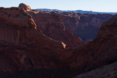
From here on out, for the rest of the day, I just walked along the rim, up and down, in and out of the peninsulas I could access, marking water and campsites in case I came back that way on the last night. I had to work past some steep stuff, but it was scenic and slow going.
It's a long way down. 700' I would say.

A little pinacle.

Lots of similar colored sandstone in the low shadows of winter made photos tricky at times.
I do love the little hanging pocket gardens.


Looking back at the little pinnacle from the other side.

Mr Shadow selfie.
The Escalante had some floating bergs in one shady spot, I watched them float into the sunshine and disappear. Lots of ice in the shade.

Looking back at a familiar sight, hidden since there is just sandstone behind it.

zoomed in a little

A little color and texture


I wandered along all of these downcanyon right peninsulas in the photo, except the next one. There was an unseen drop that was too much for me.

Lots of seeps running and hanging alcoves.

Rainbow water with algae. I am not sure if the algae is good or bad honestly, but when some pools are scummy, I can usually find others that are not. Since it is cow country water is filtered, even in shallow ephemeral pools.

Larger pools that I had marked from GE. Lots of bobcat tracks near many of these. Some had ice a couple inches thick in the shade.

Crossbedding.

SSSSSerpentine canyon below.

Some lovely views

Scouting out home. It became home for two nights, as I decided I was not going to push all the way south the next day. I was content to just wander without a destination or wearing a backpack the next day.

The walls are not as high farther downstream. Less different geological layers are exposed as you head south in this section, and there were large dunes in the abandoned meanders. So the rim was not as vertical downstream.
Tamarisk returns fast to the sludge from the bottom of the lake.

Technically it is still autumn, and you can see the canyon walls painting over the lake bleach. (those are all technical terms )
)

Wonderful sunshine.

The entrance to Fence and Cow. These have been on my list for a while. I just need enough time off during the spring to head down there. It was another reason for this trip and also a reason I wanted to go see what the end of the Lake was like. Packrafting is most desirable, given the high sediment banks, tamarisk, and ridiculous length of the river coiling on itself upstream, but not if it includes too much of a thrash and sink to reach 40 Mile and an exit.

Just sandstone domes til the horizon, with my tent tucked in there too.
For this view it was steep and looking back at it from camp it was clear. If I had lost traction...

Large overhanging cliffs at the entrance of Fence.

Again in golden colors.

Camp. For my afternoon nap the rain fly went on. It made it a nice 65d oven in there.

Turkey leftovers with a view made up 2 out of 3 meals every day. A little heavier, but it stayed cold in my cozy in the shade, and was helped by also storing the turkey with a cold ginger ale that I had saved for the last dinner. The habanero cranberry sauce upped the heat.
.jpg")
Evening twilight. It was probably not even 530pm, hahaha.

I never could stay awake to finish No Time to Die... so after watching the stars for a while through the mesh, night two's 2am feature film was Dune. It is a common staple, and I made it through about 2/3s before I fell back asleep for an hour or so. My 1-man tent has a pocket that holds the phone just right on either side, so I can lay on my side and switch sides as needed. Just gotta use my gloves behind it to keep the phone warm and not leech battery.
Thank heavens the sun rises again!
14 hours or so after it set.

This little bush will make another appearance or two. It was in a good place on top of the domes of the peninsula where I camped.

Warm.

Shadows.


I wandered south after breakfast.


False arches.

A wall of Bishop. The rim of Bishop I walked was not photogenic and just a dark line of shadow... but I am a little sad I missed it farther south where it opens up, as it looks pretty deep.

A little bit of color mostly just different shades of orange.

Grass untrammeled by cattle.

This was trammeled by cattle, and someone had gathered sticks.

Swirlies

On the highest point, as expected, I found a bench marker:

Little arch or window.

Dinners every night included more than turkey. I had brought a couple loaves of banana bread, and then this final night... the cranberry ginger ale. There was also some chocolate, cookies, orange cupcakes, Haribo Berries, pretzels and nuts.
.jpg")
Final night.
It clouded up and got breezy in the late afternoon. Which made it "colder" for the day, but would make night-time warmer.
Although for a few hours at night there were steady, strong winds with powerful gusts that provided a coating of fine sand that made it through the mesh of the tent.
The kind of night where you just bury your head until the wind stops. Then you have fine sand in the corner of your eyes, in your teeth, and all over everything when you wake up.
Once the wind stopped, the last night's feature film was The Northmen. Most of it was alright, but it got lame at the end.
The clouds took on a purple hue with the low angle of the sun.

Purple clouds and that little spindly bush again.

Some color burst through

Then even more color that burned for a long time. It was nice. albeit windy.

I woke up with the sunrise, took a bit of a sun and air bath, dried off the little bit of condensation, then packed up and headed north in the golden sun.

I stayed high this time and cut the distance and time by at least half, if not more.
Again, a well-known feature, as I got near the trailhead.

Truck on the far right horizon.

I hit the trailhead almost too quickly.
Driving out, I liked the light on the K-plateau/50 Mile Bench.

I did not want to complete the drive all at once, and figured I had a good chance of hitting traffic on I-15. The day was warming up, and the washboard road was making me rethink my choice of guzzling a liter and a half of water when I had reached the truck.
So I stopped at Devil's Garden, then wandered.
Still all alone.
After seeing so much just orange sandstone, I liked seeing some of the sandstone and other layers that had color.


This trip only increased my appetite to explore Fence and Cow during the spring sometime if I can work out the logistics.
But I am not sure I need to go rim-walking here again. There were great, vertical views, and there is interesting stuff in places, but not enough to warrant another trip.
If you want to see any of my video compilations of trips set to music, then I have one on my Insta-lame, uglyryguy. Those are just for fun.
I have not posted trip reports of past years, since there are some good places for rim and desert wandering in solitude, they are best unposted.
For me, the trick is going places where you are in full sun in the winter, where other times of the year I would melt or die of heat exhaustion.
After reaching the boat-navigable end of the Lake in September, the idea for this trip came about to travel south and see it from above. I had walked a small portion of this previously on another trip, and the airy drops, cliffs and abandoned meanders called me more than anything else.
Plus, I knew once I turned south I would be splendidly alone.
You might think that being alone, I would have thought philosophical thoughts and introspection... Hahaha, nope. Maybe I need to go alone for like a week, instead of 4 days... or maybe I am too easily distracted or shallow.
All I know is that everyone around me on this trip laughed at ALL of my jokes.
I did not go as far south as I had wanted. I spent too much time exploring along the rim.
My plans changed and I became less focused on finding the actual end of the Lake from above. I would have gotten there, if I would have followed my original plan of staying high and making a bee line to a place farther south, exploring farther south the next day, and then wandering back to the truck.
But instead I just wandered from the beginning.
With the days being short, and wanting to spend some time each day basking like a lizard to try and cure some of the winter blues, I also kept my distances short.
Which is fine by me.
I take fewer risks when I am alone, and avoided anything too steep, minus one place where I was stubborn on the side of a steep dome. I had to spread eagle to get across a drop instead of going down and back up again. Not the brightest and those are the decisions that can spiral into situations.
Oh wait! I also straddled a large crack on the rim's edge that dropped off a good 30' or more, and was only a couple feet wide (not The Crack, but another one). Besides all the time spent on the edge of the rim, that was about as much extra risk as I took.
There were a few ravens, birds, and lizards for company.
The last day I finally found a few cattle.
I saw tracks of small rodents, rabbits, bobcats, deer, and larger, more splayed hoof tracks, which I would think were bighorn sheep, but I did not see any other mammals.
It was not until the last half mile climbing to the trailhead where I scared up a couple jackrabbits.
Water was a non-issue, even though I only collected once. Finding water in perched places where the cattle do not go is usually my plan of attack. There were some potholes where I expected there to be water, and they were dry, others that I did not expect actually had water, and some were just as I had hoped. Some were frozen solid in the shade.
That's just how it goes with water.
This time I had started with 3 liters and it was about perfect for the first couple days.
I ended up not cooking, even though I had planned on some turkey tonkatsu ramen.
Thanksgiving.
After waking up early and smoking a turkey for the family lunch, I had a double serving of pie (banana cream, chocolate and berry), and then I hit the road south.
In the twilight, I narrowly avoided a big doe on the freeway near Mona, and then had a half dozen deer run across highway 20 as I climbed over into Panguitch, but no elk and no other close calls.
Escalante was a dark ghost town, so I topped off the tank and continued on. Plus it was in the 20s or something by then.
I had thought of a few places to stay the night, depending on how I felt, and by the time I hit the turn off for Chimney Rock, I had driven far enough and shaken some sense into me.
The only problem was the final tight turn for Chimney rock. I went straight on a side track instead of with the curve. I knew it immediately, but decided to see where the road went. The sand got softer and the road was rolly, and there was nowhere to easily turn around. After a half mile there was a turnaround.
I started to turn around on the slickrock of the wash. As I did the second part of the three point turn, my truck was perfectly level. I decided that was a sign.
I was also exhausted.
I turned the truck off, blew up my air mattress, threw down my sleeping bag, put a wool blanket on top so that it got the condensation, and I laid down under a dome of stars in absolute silence.
I saw some good shooting stars, watched Orion and Mars chase each other across a moonless dark sky, and fell asleep.
I woke up to some coyotes yipping, felt refreshed and looked at the time.
231am... Sheesh, there was half the night still til sunrise. I am normally a 6-7 hours sleep a night kind of guy. Used to be even less, but age and kids...
So just sleeping is not really the best option. I stood up for a minute, and then laid back down.
I had to put on "No Time to Die" to get me back to sleep, and I was still awake again at 630.
As soon as there was color on the horizon, I could see that I was actually in a pretty nice spot, with a view out towards some rolling caramel domes to the north and Chimney rock piercing the horizon to the south. I warmed up the truck, threw everything in and corrected my journey back to Chimney rock proper.
After some pics at Chimney rock, I got back in the truck and headed to my trailhead.
Someone appeared to be adventure vanning it in the parking lot, but they did not come outside while I packed up. Within a few minutes I dropped off toward the rim walking in the sand.
According to the register, one intrepid group had stayed the night in the canyon- that had to be cold, and the other visitors had all been day hikers for the past week or so.
At very first, I bent purposely north off trail, adding some extra distance, just because. I hit the rim and wandered along the rim around until I came back to what to many might be a familiar sight to many:
From here on out, for the rest of the day, I just walked along the rim, up and down, in and out of the peninsulas I could access, marking water and campsites in case I came back that way on the last night. I had to work past some steep stuff, but it was scenic and slow going.
It's a long way down. 700' I would say.
A little pinacle.
Lots of similar colored sandstone in the low shadows of winter made photos tricky at times.
I do love the little hanging pocket gardens.
Looking back at the little pinnacle from the other side.
Mr Shadow selfie.
The Escalante had some floating bergs in one shady spot, I watched them float into the sunshine and disappear. Lots of ice in the shade.
Looking back at a familiar sight, hidden since there is just sandstone behind it.
zoomed in a little
A little color and texture
I wandered along all of these downcanyon right peninsulas in the photo, except the next one. There was an unseen drop that was too much for me.
Lots of seeps running and hanging alcoves.
Rainbow water with algae. I am not sure if the algae is good or bad honestly, but when some pools are scummy, I can usually find others that are not. Since it is cow country water is filtered, even in shallow ephemeral pools.
Larger pools that I had marked from GE. Lots of bobcat tracks near many of these. Some had ice a couple inches thick in the shade.
Crossbedding.
SSSSSerpentine canyon below.
Some lovely views
Scouting out home. It became home for two nights, as I decided I was not going to push all the way south the next day. I was content to just wander without a destination or wearing a backpack the next day.
The walls are not as high farther downstream. Less different geological layers are exposed as you head south in this section, and there were large dunes in the abandoned meanders. So the rim was not as vertical downstream.
Tamarisk returns fast to the sludge from the bottom of the lake.
Technically it is still autumn, and you can see the canyon walls painting over the lake bleach. (those are all technical terms
)Wonderful sunshine.
The entrance to Fence and Cow. These have been on my list for a while. I just need enough time off during the spring to head down there. It was another reason for this trip and also a reason I wanted to go see what the end of the Lake was like. Packrafting is most desirable, given the high sediment banks, tamarisk, and ridiculous length of the river coiling on itself upstream, but not if it includes too much of a thrash and sink to reach 40 Mile and an exit.
Just sandstone domes til the horizon, with my tent tucked in there too.
For this view it was steep and looking back at it from camp it was clear. If I had lost traction...
Large overhanging cliffs at the entrance of Fence.
Again in golden colors.
Camp. For my afternoon nap the rain fly went on. It made it a nice 65d oven in there.
Turkey leftovers with a view made up 2 out of 3 meals every day. A little heavier, but it stayed cold in my cozy in the shade, and was helped by also storing the turkey with a cold ginger ale that I had saved for the last dinner. The habanero cranberry sauce upped the heat.
Evening twilight. It was probably not even 530pm, hahaha.
I never could stay awake to finish No Time to Die... so after watching the stars for a while through the mesh, night two's 2am feature film was Dune. It is a common staple, and I made it through about 2/3s before I fell back asleep for an hour or so. My 1-man tent has a pocket that holds the phone just right on either side, so I can lay on my side and switch sides as needed. Just gotta use my gloves behind it to keep the phone warm and not leech battery.
Thank heavens the sun rises again!
14 hours or so after it set.
This little bush will make another appearance or two. It was in a good place on top of the domes of the peninsula where I camped.
Warm.
Shadows.
I wandered south after breakfast.
False arches.
A wall of Bishop. The rim of Bishop I walked was not photogenic and just a dark line of shadow... but I am a little sad I missed it farther south where it opens up, as it looks pretty deep.
A little bit of color mostly just different shades of orange.
Grass untrammeled by cattle.
This was trammeled by cattle, and someone had gathered sticks.
Swirlies
On the highest point, as expected, I found a bench marker:
Little arch or window.
Dinners every night included more than turkey. I had brought a couple loaves of banana bread, and then this final night... the cranberry ginger ale. There was also some chocolate, cookies, orange cupcakes, Haribo Berries, pretzels and nuts.
Final night.
It clouded up and got breezy in the late afternoon. Which made it "colder" for the day, but would make night-time warmer.
Although for a few hours at night there were steady, strong winds with powerful gusts that provided a coating of fine sand that made it through the mesh of the tent.
The kind of night where you just bury your head until the wind stops. Then you have fine sand in the corner of your eyes, in your teeth, and all over everything when you wake up.
Once the wind stopped, the last night's feature film was The Northmen. Most of it was alright, but it got lame at the end.
The clouds took on a purple hue with the low angle of the sun.
Purple clouds and that little spindly bush again.
Some color burst through
Then even more color that burned for a long time. It was nice. albeit windy.
I woke up with the sunrise, took a bit of a sun and air bath, dried off the little bit of condensation, then packed up and headed north in the golden sun.
I stayed high this time and cut the distance and time by at least half, if not more.
Again, a well-known feature, as I got near the trailhead.
Truck on the far right horizon.
I hit the trailhead almost too quickly.
Driving out, I liked the light on the K-plateau/50 Mile Bench.
I did not want to complete the drive all at once, and figured I had a good chance of hitting traffic on I-15. The day was warming up, and the washboard road was making me rethink my choice of guzzling a liter and a half of water when I had reached the truck.
So I stopped at Devil's Garden, then wandered.
Still all alone.
After seeing so much just orange sandstone, I liked seeing some of the sandstone and other layers that had color.
This trip only increased my appetite to explore Fence and Cow during the spring sometime if I can work out the logistics.
But I am not sure I need to go rim-walking here again. There were great, vertical views, and there is interesting stuff in places, but not enough to warrant another trip.
If you want to see any of my video compilations of trips set to music, then I have one on my Insta-lame, uglyryguy. Those are just for fun.