- Joined
- Aug 23, 2016
- Messages
- 144
I had been planning a trip starting in the western Teton Wilderness and exiting somewhere along hwy 287 when I saw talk of a trip up Hidden Creek by members of this forum. I thought I might try to see Hidden Creek on my trip, and we were going to be up there around the same time, so I asked if I could join them. They graciously agreed. The plan was to see if it was possible to exit upper Hidden Creek and descend via a couple of hanging valleys to the north fork of the Yellowstone. This turned out not to be feasible but it was great to see upper Hidden Creek and meet these fine folks.
I have a fascination for the western Teton Wilderness. A few years ago I did a trip starting at Arizona Creek. Two years ago my wife and I looped through there and came out at Pilgrim Creek. This year I gave Pacific Creek a try. The western TW has no spectacular peaks or dramatic views but it is magical in its own subtle way. It is a huge area and just a maze of beautiful creeks and meadows that you sort of get absorbed into. And I really enjoy the transition from the "creeks and meadows" country to the dramatic long, deep valleys and high mountains of the Absorokas further east.
Pre-trip: The Subaru camper

This was the maiden voyage for my Subaru Outback "camper". I took out the back seat and built a platform for sleeping and drawers for storage. With no back seat there is a large cavern under the front part of the platform. The main drawback is lack of headroom. You cannot sit up at all in the back. But it sure is great to be able to drive into a camping spot and not worry about finding a decent place to pitch a tent. And in the morning you just drive off!

The whole kitchen fits in one drawer. The drawers have covers so they can double as counter space.

I cruised around for a few days and ended up a the Pacific Creek trailhead campground for final preparations.
Forgot to include the map. Adding it now as an edit. Note that the off-trail paths on the map are approximate.
Click here to view on CalTopo
Day 1: A little way up Pacific Creek
I had planned to spend the night at the trailhead and get a good early start the next day. But as I was getting my gear organized I realized I could just cook my dinner right then and make it a few miles up the trail before nightfall. So that's what I did.

Looking up Pacific Creek after it opens up a bit. Normally, so I am told, there are spectacular views of the Tetons from Pacific Creek. But there was so much smoke that you could not even see the Tetons from the highway in front of them, much less from here.

I camped near the large pine trees in the center of this photo but on the other side of the creek. Later, @scatman told me there was a nice campsite in the same area but on this side of the creek. I must have walked right past it.


There were bear and wolf tracks on the streambanks.

I had great views up and down the creek and across the meadows. Looked for but did not see any wildlife.
Day 2: To Mink Creek. A mellow day of creeks and meadows.

Confluence of Pacific and Mink Creeks. The trail up Pacific Creek heads over Two Ocean Pass. I headed up Mink Creek instead.

View of Pacific Creek just upstream from the confluence.

Crummy picture of cool owl. I believe it is a great gray owl. I watched it for a while with binoculars. It swiveled its head all around as owls will do.

Saw this deer a few minutes later. Stood watching me for a long time.
Day 3 To upper Mink Creek. Another day of creeks and meadows

Meadow where I camped on night two. My tent is in the trees on the right. This picture is from my kitchen the next morning. Clearer air today.

Upper Mink Creek valley is ahead. Here the creek is off to the left in a bit of a gorge.

This is my kitchen area at Camp 3. My tent is barely visible in the trees in the distance. About now is when I realized I had left my extra camera batteries in the car. If I wanted any pictures from the later part of the trip I would need to seriously curtail my photography! So no other pictures of this campsite.
Day 4: Mink Creek to lower Thorofare Creek

Headwaters of Falcon Creek starting down toward Yellowstone River.

Near the mouth of Falcon Creek. Looking at the Yellowstone River, Bridger Lake and, in the distance, Thorofare Creek valley, which is where I am headed. You can see the trail in the meadow below leading to the ford of the Yellowstone. It can be pretty deep here but the water was relatively low now so only thigh deep with a gentle current. On the other side the trail continues through the meadows then along the edge of the trees from left to right (north to south). There are outfitter camps in the trees there where there is usually a group or two camped. The mountain on the right is Hawk's Rest and the Hawk's Rest Patrol Cabin is at its base.

Similar view but with even more Indian paintbrush flowers. There were loads of them here

This is Rooster. He was up here for a month-long trip with his dog, his horse and two mules. He was staying at one of the outfitter camps. The camps have bear-boxes so it is convenient, especially if you have a month's worth of food to store.

This shot was taken from the spring at the Hawk's Rest cabin looking west. The spring is behind me. The large structure in the middle distance is a pack bridge over the Yellowstone on the trail coming in from Two-Ocean Pass. Falcon Creek valley is just off the picture to the right.
It was a long, hot hike from here to Thorofare Creek. This whole area burned in 1988 and the area between here and Thorofare Creek has grown up with dense stands of small pine trees. They don't offer much in the way of shade and they also block the breeze, sort of adding insult to injury. My campsite was nice, if nondescript, in a meadow surrounded by more mature timber. But it did have good access to the creek and a great swimming hole so I was able to cool off. Oh--and at about 2 or 3 AM a large hoofed animal came barreling through camp. It was big enough that I felt the ground vibrate under my head as it crashed on by. A moose?
Day 5: To mouth of Hidden Creek
The planned rendezvous with the Hidden Creek Headwaters Expedition was not until tomorrow night but I was ahead of schedule and decided to camp at the meeting point tonight and day-hike up the trail to see if I could meet them on their way in.

Typical scenery of lower Thorofare Creek. Ahead on the left you can see the side-canyon where Open Creek comes in. I think the prominent mountain in the distance is Thorofare Buttes.

Looking downstream toward last night's camp

Hidden Creek valley is ahead on the right. It is a very large hanging valley and not very apparent--at least not apparent as such a large valley--when you are at its mouth.

At the mouth of Hidden Creek there is a large meadow with a bear box. When I arrived the bear box had been in the full sun for hours. I think you could have baked bread in there. From here you really have no idea what is up along the aptly named Hidden Creek. I set up my tent in the shade of some trees off to the left
Day 6: Encounter with the Hidden Creek Headwaters Expedition and first glimpse of Hidden Creek valley

I got up early and climbed up the ridge north of camp to watch the sun rise and have breakfast up there. From here you get a better idea of Hidden Creek. Hidden Creek itself flows out the chasm on the left. The trail goes up the shallow valley on the right. A little way up the valley forks. The main fork, where we went, is to the left.

This photo is courtesy of @TractorDoc. I headed up the trail hoping to meet the group on their way to the mouth of Hidden Creek. I was far away into some deep recess of my head when I heard a voice say, "you looking for us?" They had stopped to look at an old cabin just off the trail and I nearly strolled right on by. Anyway, we made our introductions and took some group pictures. They were also ahead of schedule and intended to stay that night at an outfitter camp part way up Hidden Creek. I took off to break camp and hopefully be ready to go when they caught up. L to R: @b.stark, @futurafree, @Georgia Yankee, @wsp_scott, @Bob, @scatman, @TractorDoc

We crossed Thorofare Creek and started up. It doesn't look like it in this picture but it was a really hot climb. With horseflies. Lots of horseflies.

L to R: @b.stark, @TractorDoc, @scatman, @Bob, @wsp_scott. I need to mention that pretty much all of my photos from here on out are made possible by @b.stark. I shared my tragic story of forgotten camera batteries and he offered me one of his. Turns out we have the same camera model. Many thanks!
Day 7: Upper Hidden Creek Meadows
The plan today was to get to upper Hidden Creek and have a look at a possible route up and over the top of the canyon. Turned out that with the naked eye it did not look good. With binoculars it looked awful, and on closer in-person assessment it looked positively miserable. So we would not be attempting it. We did, however, get to camp in a beautiful site that is rarely visited. Thinking about it, Hidden Creek is a long side-trip off of an already long trip any way you try to do it. A few intrepid individuals decided to bushwhack up the canyon and get a closer look at the waterfall. I was feeling lazy so decided I would tag along until it felt like work and then head back to camp. Stay tuned for other members' trip reports. I'm sure there will be details of this jaunt.

Getting into upper Hidden Creek meadows

We'll be camping at about the furthest meadow visible in this photo.

View down Hidden Creek from camp

Some of the more pleasant country on the way to see the waterfall.
Day 8: We go our separate ways.
With the Hidden Creek route off the menu it was time to head out. Some of the group were going more or less straight back to Deer Creek, others were taking a few more days. I needed to continue up Thorofare Creek to make my exit via Turpin Meadows. I said goodbye to the group and headed back down the valley.

Leaving Hidden Creek meadow

View down the valley with one of the valley's many springs in the foreground

One last view of the upper meadow

We had some lively discussions about the proliferation of cairns in the backcountry. @Bob was an especially enthusiastic advocate of the "no cairn is a good cairn" view. In order to provide him something to do on the hike out besides swatting horseflies, I built him a few cairns to knock down. I heard later that others in the group robbed @Bob of the pleasure and got to them before he could.

Today I wanted to get close enough to upper Thorofare Creek that I would have a reasonably short day for getting up and over and into north fork Yellowstone. I didn't look at the map all that closely but just figured since I was hiking in a big valley with a big creek there would be plenty of nice camping spots along the way. Short story is I was wrong and ended up walking 15 miles to a somewhat ok spot, Oh well, it got me set up for tomorrow. I ended up at the mouth of Bruin Creek, which is the last valley coming in from the left in the photo above. It was hot again today and at least my campsite had a creek I could get in and cool off.

Rocky tent site in scrubby pines. Probably the least comfortable site of the whole trip but I was so exhausted I didn't notice.

At Bruin Creek looking down Thorofare Creek.
Day 9: Majo Pass
Others in this group have written about an old outfitter route from Thorofare Creek to the north fork of the Yellowstone River. I think it was @scatman who came across the name, Majo Pass. Anyway, that is my route for today. There is an outfitter trail of sorts up through there but even with no trail it is a reasonable bushwhack/scramble.

A little past Bruin Creek Thorofare Creek valley greens up and the scenery changes dramatically. Majo pass goes up behind the ridge extending from the upper right to the center of the photo.

Looking down the valley.

I think these flowers are rocky mountain fringed gentian

Getting up toward Majo Pass. There is a bit of a cirque part way up with nice meadows.

The "trail" near the top is really steep. Sort of hard to get the perspective of this photo but the camera is looking steeply downward

Looking down toward Thorofare Creek from near Majo Pass

Almost there! Uh-oh. Where did that weather come from?

I got down to the meadow below as fast as I could and got the tent up just before the rain hit.


The best thing about this Durston tent is you can set up just the fly quickly and dive in with all your gear to escape a storm. In this case the weather was sort of all bark and no bite. Blew a little, rained a little but never got serious.

Interesting clouds for a while

Looking back up toward the pass. I think @scatman, @wsp_scott, @TractorDoc, and @Bob camped in almost this exact spot last year.

It really is a pretty little valley. I should have stayed here another night and spent some more time wandering around.
Day 10: Off to Ferry Lake
I had not intended to go all the way to Ferry Lake today but it turned out to be a less extreme repeat of Day 8. At one point I figured I'd go "a little further", which turned out to be about 5 more miles to Ferry Lake

Heading down into the north fork of the Yellowstone. Getting smoky again. I followed a pretty good trail for a while but it ended in a maze of downfall and I descended the rest of the way on intermittent elk trails. But overall not bad at all. I thought I would find the old trail in the north fork as soon as I got down there but I had to bushwhack up the valley for a good distance before I found it.

In the north fork looking downvalley. The route from Majo Pass comes down the nearest side valley on the right.

Waterfall on the west side of the canyon

Looking up toward the pass over to the south fork. It was smoky and I was headed into the sun so photos in this direction don't look so good. There is a pretty good trail all the way up and over.

Looking over into the top of the south fork of the Yellowstone. The south fork flows down to the right. There is a trail from here that contours around fairly high from L to R and eventually joins the south fork Yellowstone trail. Thanks @Bob for letting me know that this trail contours around higher that you might think. There is a large white piece of petrified wood in the R foreground. I think I have seen this exact piece in other peoples' photos from here.

Looking back from part way around

I like this picture because it shows the kind of volcanic junk these mountains are made of.

And here's the pretty little tarn that you are obliged to take a picture of when you come this way!

The trail coming up the south fork of the Yellowstone is down there, coming in from the right.

One last look back toward Younts Peak

The trail toward Ferry Lake. I found a nice little campsite in the trees to the right of the trail up ahead. I walked a good distance off of the trail and up, over and around stuff. But just as I found the perfect tent site I noticed the trail about twenty feet from where I was standing. It had wrapped around in an alternate route to the same spot. I figured there would be similar places just ahead so I set out down the trail. Of course there was nowhere that looked good to me so I ended up going all the way to Ferry Lake, which I really did not want to do. Oh well, at least the trail was in good condition and there was not too much relief. Except for the very last bit, of course.

The trail here is just south of the continental divide. South of the trail all the streams drop off pretty steeply to eventually flow into the South Buffalo Fork.

Ferry Lake. It was bigger than I had expected. There is a bear box near the outlet, which is just left of center in the photo. Again you can see how everything here drops precipitously into the South Buffalo Fork.

My campsite at Ferry Lake. There are some waterfalls here but the light was terrible and I didn't bother trying to take any photos. But if I am being honest, I was just too tired to care about any d*** waterfalls!
Day 10: Decision time
From here I had mapped out different options for the last part of the trip. Up along the continental divide and down the North Buffalo Fork via a couple of possible routes or straight down Soda Fork. Either way ending up at Turpin Meadows. I'll tell you how it went. I stood there and looked UP toward the North Buffalo Fork routes and DOWN the Soda Fork route. My feet were tired, I'd had enough of the smoke and I missed my wife, so down I went!

Just the other side of Ferry Lake. Soda Fork is through the low pass to the left. To North Buffalo Fork go up toward the skyline. It was a gloomy day but that kept it cool and made for some interesting light.

Dropping down toward Soda Fork. Besides the smoke I think it was a little foggy. Made for a spooky atmosphere that I was not really able to capture with these pictures.

The flowers were nice and the trail was surprisingly well-maintained. I figured out later that this was part of the CDT. It was not hard to figure out after I met a couple of CDT hikers!

That's Crater Lake back there. I kept waiting for a decent picture opportunity and finally had to just snap this one. I would normally just merrily snap away and delete the bad ones but my camera battery was critically low at this point. I had to put it in my armpit to warm it up to take this one! Crater Lake sits in sort of a crater and has no surface outlet.

Pond below Crater Lake. I stopped here to dry the dew off of my tent and have a snack. Just as I started again out a party came by on horseback. Maybe six customers plus two wranglers. The trail was really dusty so the last riders in line were in a cloud of dust from the first riders. I hope they traded off positions.

This is Big Soda Spring. It is the presumed outlet for Crater Lake. Soda Fork emerges here pretty much in its entirety.

I followed a set of bear and wolf tracks down the trail for over a mile. The trail was covered in very fine dust and you could see the fine texture of the skin on the bear's feet. Never did see the actual animals, however.
Today I decided I would stop for the night at an outfitter camp I saw on the satellite image. No more going on and on looking for a perfect campsite. The outfitter camp was nice in that there was a large meadow and great access to a swimming hole on Soda Fork but it was sort of trashed out. My camera battery was running on empty so I didn't bother with a photo.
Day 11: Hiking out to Turpin Meadow then hitching back to my car at Pacific Creek.
This day started out a comedy of errors. From my campsite there was an outfitter trail that looked like it would shave at least half a mile off of my hike out by taking a more direct route over to the North Buffalo Fork trail. A shortcut! On a horse trail! What could go wrong? After a quarter mile or so it was clear that I would be in total mud and back and forth through channels of Soda Fork for some time. So I abandoned that plan. Now I needed to backtrack to get on my original route. But c'mon...backtrack? No way--I'm moving forward. So I found a trail that looked like a nice shortcut from my original shortcut back to the official trail. Well, you know how that turned out. After stepping over abut 10,000 fallen trees and negotiating numerous mudholes I finally did reach the trail but, jeez, as my childhood friend Peter S. would have said, "how dumb can ya get?"

Finally on the main Buffalo Fork trail. Parts of it are multilane highways.

Every trail has to have one good climb right at the end. Here it is on this trail. My camera battery finally died completely at this point so this is the last picture. Turpin Meadow is maybe a quarter mile from here so this was the end of my trail hiking. But it is the start of the secondary adventure--hitchhiking back to my car...
@Bob suggested once I got to Turpin Meadow my best bet might be to walk the gravel road to the highway rather than try to hitch the longer paved road from Turpin. Turned out to be the best option as there was approximately zero traffic out of here. I estimated the distance on the gravel road to be about 4 miles, and since it was downhill, it would be a breeze. I'd be to the hwy in no time flat. Well, I kept waiting for the downhill part to begin. Around one curve and then another. Since I was surely just about to the downhill part I did not want to stop and rest, or even slow down, until I got to the top if this little hill I was on. I honestly don't know where I got the idea this was going to be downhill. It was a climb of just about 1000 feet! By the time I got to the highway I was battered and just completely spent. The thing that saved me from real trouble was that it clouded over so I didn't get too hot or dehydrated.
Anyway I got a ride in about 20 minutes with a young guy who was sort of an itinerant trail worker. He was between jobs and was headed to GTNP to meet up with a friend. He took me right up to the Pacific Creek campground and dropped me at my car.
My friends Bryan and Wendy were staying at the Colter Bay "Tent Village" campground and had invited me to crash with them if I got out in time. So I drove up the Pilgrim Creek Road and took a dip in the creek to get the trail dust off of me and found them at their tent-cabin accommodations

Normally after a trip like this I don't really crave much of anything to eat or drink but this time I was absolutely dying for a beer and something--anything--salty to go with it. Bryan and Wendy needed ice so Bryan and I headed up to the gas station by the highway for ice and a six pack of Old Faithful Ale. I had some stale but very salty chips in the car and the combination was perfect!
Another great trip overall. I could have done without the smoke but there were enough clear days and nights in the mix. Except for a few hot days the weather was good. I saw some new country and, best of all, got to meet a great group of BCP folks. Every other time I have been in the Teton Wilderness I have seen bears but not this time. I saw a lot of fresh tracks and scat so I know they were out there. I guess they just didn't want me to see them. And I think I saw more fresh wolf tracks on this trip than any other but again I didn't see or hear them. Maybe next time. Already looking forward to the next trip!
I have a fascination for the western Teton Wilderness. A few years ago I did a trip starting at Arizona Creek. Two years ago my wife and I looped through there and came out at Pilgrim Creek. This year I gave Pacific Creek a try. The western TW has no spectacular peaks or dramatic views but it is magical in its own subtle way. It is a huge area and just a maze of beautiful creeks and meadows that you sort of get absorbed into. And I really enjoy the transition from the "creeks and meadows" country to the dramatic long, deep valleys and high mountains of the Absorokas further east.
Pre-trip: The Subaru camper
This was the maiden voyage for my Subaru Outback "camper". I took out the back seat and built a platform for sleeping and drawers for storage. With no back seat there is a large cavern under the front part of the platform. The main drawback is lack of headroom. You cannot sit up at all in the back. But it sure is great to be able to drive into a camping spot and not worry about finding a decent place to pitch a tent. And in the morning you just drive off!
The whole kitchen fits in one drawer. The drawers have covers so they can double as counter space.
I cruised around for a few days and ended up a the Pacific Creek trailhead campground for final preparations.
Forgot to include the map. Adding it now as an edit. Note that the off-trail paths on the map are approximate.
Click here to view on CalTopo
Day 1: A little way up Pacific Creek
I had planned to spend the night at the trailhead and get a good early start the next day. But as I was getting my gear organized I realized I could just cook my dinner right then and make it a few miles up the trail before nightfall. So that's what I did.
Looking up Pacific Creek after it opens up a bit. Normally, so I am told, there are spectacular views of the Tetons from Pacific Creek. But there was so much smoke that you could not even see the Tetons from the highway in front of them, much less from here.
I camped near the large pine trees in the center of this photo but on the other side of the creek. Later, @scatman told me there was a nice campsite in the same area but on this side of the creek. I must have walked right past it.
There were bear and wolf tracks on the streambanks.
I had great views up and down the creek and across the meadows. Looked for but did not see any wildlife.
Day 2: To Mink Creek. A mellow day of creeks and meadows.
Confluence of Pacific and Mink Creeks. The trail up Pacific Creek heads over Two Ocean Pass. I headed up Mink Creek instead.
View of Pacific Creek just upstream from the confluence.
Crummy picture of cool owl. I believe it is a great gray owl. I watched it for a while with binoculars. It swiveled its head all around as owls will do.
Saw this deer a few minutes later. Stood watching me for a long time.
Day 3 To upper Mink Creek. Another day of creeks and meadows
Meadow where I camped on night two. My tent is in the trees on the right. This picture is from my kitchen the next morning. Clearer air today.
Upper Mink Creek valley is ahead. Here the creek is off to the left in a bit of a gorge.
This is my kitchen area at Camp 3. My tent is barely visible in the trees in the distance. About now is when I realized I had left my extra camera batteries in the car. If I wanted any pictures from the later part of the trip I would need to seriously curtail my photography! So no other pictures of this campsite.
Day 4: Mink Creek to lower Thorofare Creek
Headwaters of Falcon Creek starting down toward Yellowstone River.
Near the mouth of Falcon Creek. Looking at the Yellowstone River, Bridger Lake and, in the distance, Thorofare Creek valley, which is where I am headed. You can see the trail in the meadow below leading to the ford of the Yellowstone. It can be pretty deep here but the water was relatively low now so only thigh deep with a gentle current. On the other side the trail continues through the meadows then along the edge of the trees from left to right (north to south). There are outfitter camps in the trees there where there is usually a group or two camped. The mountain on the right is Hawk's Rest and the Hawk's Rest Patrol Cabin is at its base.
Similar view but with even more Indian paintbrush flowers. There were loads of them here
This is Rooster. He was up here for a month-long trip with his dog, his horse and two mules. He was staying at one of the outfitter camps. The camps have bear-boxes so it is convenient, especially if you have a month's worth of food to store.
This shot was taken from the spring at the Hawk's Rest cabin looking west. The spring is behind me. The large structure in the middle distance is a pack bridge over the Yellowstone on the trail coming in from Two-Ocean Pass. Falcon Creek valley is just off the picture to the right.
It was a long, hot hike from here to Thorofare Creek. This whole area burned in 1988 and the area between here and Thorofare Creek has grown up with dense stands of small pine trees. They don't offer much in the way of shade and they also block the breeze, sort of adding insult to injury. My campsite was nice, if nondescript, in a meadow surrounded by more mature timber. But it did have good access to the creek and a great swimming hole so I was able to cool off. Oh--and at about 2 or 3 AM a large hoofed animal came barreling through camp. It was big enough that I felt the ground vibrate under my head as it crashed on by. A moose?
Day 5: To mouth of Hidden Creek
The planned rendezvous with the Hidden Creek Headwaters Expedition was not until tomorrow night but I was ahead of schedule and decided to camp at the meeting point tonight and day-hike up the trail to see if I could meet them on their way in.
Typical scenery of lower Thorofare Creek. Ahead on the left you can see the side-canyon where Open Creek comes in. I think the prominent mountain in the distance is Thorofare Buttes.
Looking downstream toward last night's camp
Hidden Creek valley is ahead on the right. It is a very large hanging valley and not very apparent--at least not apparent as such a large valley--when you are at its mouth.
At the mouth of Hidden Creek there is a large meadow with a bear box. When I arrived the bear box had been in the full sun for hours. I think you could have baked bread in there. From here you really have no idea what is up along the aptly named Hidden Creek. I set up my tent in the shade of some trees off to the left
Day 6: Encounter with the Hidden Creek Headwaters Expedition and first glimpse of Hidden Creek valley
I got up early and climbed up the ridge north of camp to watch the sun rise and have breakfast up there. From here you get a better idea of Hidden Creek. Hidden Creek itself flows out the chasm on the left. The trail goes up the shallow valley on the right. A little way up the valley forks. The main fork, where we went, is to the left.
This photo is courtesy of @TractorDoc. I headed up the trail hoping to meet the group on their way to the mouth of Hidden Creek. I was far away into some deep recess of my head when I heard a voice say, "you looking for us?" They had stopped to look at an old cabin just off the trail and I nearly strolled right on by. Anyway, we made our introductions and took some group pictures. They were also ahead of schedule and intended to stay that night at an outfitter camp part way up Hidden Creek. I took off to break camp and hopefully be ready to go when they caught up. L to R: @b.stark, @futurafree, @Georgia Yankee, @wsp_scott, @Bob, @scatman, @TractorDoc
We crossed Thorofare Creek and started up. It doesn't look like it in this picture but it was a really hot climb. With horseflies. Lots of horseflies.
L to R: @b.stark, @TractorDoc, @scatman, @Bob, @wsp_scott. I need to mention that pretty much all of my photos from here on out are made possible by @b.stark. I shared my tragic story of forgotten camera batteries and he offered me one of his. Turns out we have the same camera model. Many thanks!
Day 7: Upper Hidden Creek Meadows
The plan today was to get to upper Hidden Creek and have a look at a possible route up and over the top of the canyon. Turned out that with the naked eye it did not look good. With binoculars it looked awful, and on closer in-person assessment it looked positively miserable. So we would not be attempting it. We did, however, get to camp in a beautiful site that is rarely visited. Thinking about it, Hidden Creek is a long side-trip off of an already long trip any way you try to do it. A few intrepid individuals decided to bushwhack up the canyon and get a closer look at the waterfall. I was feeling lazy so decided I would tag along until it felt like work and then head back to camp. Stay tuned for other members' trip reports. I'm sure there will be details of this jaunt.
Getting into upper Hidden Creek meadows
We'll be camping at about the furthest meadow visible in this photo.
View down Hidden Creek from camp
Some of the more pleasant country on the way to see the waterfall.
Day 8: We go our separate ways.
With the Hidden Creek route off the menu it was time to head out. Some of the group were going more or less straight back to Deer Creek, others were taking a few more days. I needed to continue up Thorofare Creek to make my exit via Turpin Meadows. I said goodbye to the group and headed back down the valley.
Leaving Hidden Creek meadow
View down the valley with one of the valley's many springs in the foreground
One last view of the upper meadow
We had some lively discussions about the proliferation of cairns in the backcountry. @Bob was an especially enthusiastic advocate of the "no cairn is a good cairn" view. In order to provide him something to do on the hike out besides swatting horseflies, I built him a few cairns to knock down. I heard later that others in the group robbed @Bob of the pleasure and got to them before he could.
Today I wanted to get close enough to upper Thorofare Creek that I would have a reasonably short day for getting up and over and into north fork Yellowstone. I didn't look at the map all that closely but just figured since I was hiking in a big valley with a big creek there would be plenty of nice camping spots along the way. Short story is I was wrong and ended up walking 15 miles to a somewhat ok spot, Oh well, it got me set up for tomorrow. I ended up at the mouth of Bruin Creek, which is the last valley coming in from the left in the photo above. It was hot again today and at least my campsite had a creek I could get in and cool off.
Rocky tent site in scrubby pines. Probably the least comfortable site of the whole trip but I was so exhausted I didn't notice.
At Bruin Creek looking down Thorofare Creek.
Day 9: Majo Pass
Others in this group have written about an old outfitter route from Thorofare Creek to the north fork of the Yellowstone River. I think it was @scatman who came across the name, Majo Pass. Anyway, that is my route for today. There is an outfitter trail of sorts up through there but even with no trail it is a reasonable bushwhack/scramble.
A little past Bruin Creek Thorofare Creek valley greens up and the scenery changes dramatically. Majo pass goes up behind the ridge extending from the upper right to the center of the photo.
Looking down the valley.
I think these flowers are rocky mountain fringed gentian
Getting up toward Majo Pass. There is a bit of a cirque part way up with nice meadows.
The "trail" near the top is really steep. Sort of hard to get the perspective of this photo but the camera is looking steeply downward
Looking down toward Thorofare Creek from near Majo Pass
Almost there! Uh-oh. Where did that weather come from?
I got down to the meadow below as fast as I could and got the tent up just before the rain hit.
The best thing about this Durston tent is you can set up just the fly quickly and dive in with all your gear to escape a storm. In this case the weather was sort of all bark and no bite. Blew a little, rained a little but never got serious.
Interesting clouds for a while
Looking back up toward the pass. I think @scatman, @wsp_scott, @TractorDoc, and @Bob camped in almost this exact spot last year.
It really is a pretty little valley. I should have stayed here another night and spent some more time wandering around.
Day 10: Off to Ferry Lake
I had not intended to go all the way to Ferry Lake today but it turned out to be a less extreme repeat of Day 8. At one point I figured I'd go "a little further", which turned out to be about 5 more miles to Ferry Lake
Heading down into the north fork of the Yellowstone. Getting smoky again. I followed a pretty good trail for a while but it ended in a maze of downfall and I descended the rest of the way on intermittent elk trails. But overall not bad at all. I thought I would find the old trail in the north fork as soon as I got down there but I had to bushwhack up the valley for a good distance before I found it.
In the north fork looking downvalley. The route from Majo Pass comes down the nearest side valley on the right.
Waterfall on the west side of the canyon
Looking up toward the pass over to the south fork. It was smoky and I was headed into the sun so photos in this direction don't look so good. There is a pretty good trail all the way up and over.
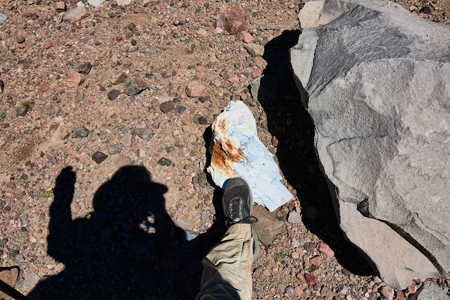
Looking over into the top of the south fork of the Yellowstone. The south fork flows down to the right. There is a trail from here that contours around fairly high from L to R and eventually joins the south fork Yellowstone trail. Thanks @Bob for letting me know that this trail contours around higher that you might think. There is a large white piece of petrified wood in the R foreground. I think I have seen this exact piece in other peoples' photos from here.
Looking back from part way around
I like this picture because it shows the kind of volcanic junk these mountains are made of.
And here's the pretty little tarn that you are obliged to take a picture of when you come this way!
The trail coming up the south fork of the Yellowstone is down there, coming in from the right.
One last look back toward Younts Peak
The trail toward Ferry Lake. I found a nice little campsite in the trees to the right of the trail up ahead. I walked a good distance off of the trail and up, over and around stuff. But just as I found the perfect tent site I noticed the trail about twenty feet from where I was standing. It had wrapped around in an alternate route to the same spot. I figured there would be similar places just ahead so I set out down the trail. Of course there was nowhere that looked good to me so I ended up going all the way to Ferry Lake, which I really did not want to do. Oh well, at least the trail was in good condition and there was not too much relief. Except for the very last bit, of course.
The trail here is just south of the continental divide. South of the trail all the streams drop off pretty steeply to eventually flow into the South Buffalo Fork.
Ferry Lake. It was bigger than I had expected. There is a bear box near the outlet, which is just left of center in the photo. Again you can see how everything here drops precipitously into the South Buffalo Fork.
My campsite at Ferry Lake. There are some waterfalls here but the light was terrible and I didn't bother trying to take any photos. But if I am being honest, I was just too tired to care about any d*** waterfalls!
Day 10: Decision time
From here I had mapped out different options for the last part of the trip. Up along the continental divide and down the North Buffalo Fork via a couple of possible routes or straight down Soda Fork. Either way ending up at Turpin Meadows. I'll tell you how it went. I stood there and looked UP toward the North Buffalo Fork routes and DOWN the Soda Fork route. My feet were tired, I'd had enough of the smoke and I missed my wife, so down I went!
Just the other side of Ferry Lake. Soda Fork is through the low pass to the left. To North Buffalo Fork go up toward the skyline. It was a gloomy day but that kept it cool and made for some interesting light.
Dropping down toward Soda Fork. Besides the smoke I think it was a little foggy. Made for a spooky atmosphere that I was not really able to capture with these pictures.
The flowers were nice and the trail was surprisingly well-maintained. I figured out later that this was part of the CDT. It was not hard to figure out after I met a couple of CDT hikers!
That's Crater Lake back there. I kept waiting for a decent picture opportunity and finally had to just snap this one. I would normally just merrily snap away and delete the bad ones but my camera battery was critically low at this point. I had to put it in my armpit to warm it up to take this one! Crater Lake sits in sort of a crater and has no surface outlet.
Pond below Crater Lake. I stopped here to dry the dew off of my tent and have a snack. Just as I started again out a party came by on horseback. Maybe six customers plus two wranglers. The trail was really dusty so the last riders in line were in a cloud of dust from the first riders. I hope they traded off positions.
This is Big Soda Spring. It is the presumed outlet for Crater Lake. Soda Fork emerges here pretty much in its entirety.
I followed a set of bear and wolf tracks down the trail for over a mile. The trail was covered in very fine dust and you could see the fine texture of the skin on the bear's feet. Never did see the actual animals, however.
Today I decided I would stop for the night at an outfitter camp I saw on the satellite image. No more going on and on looking for a perfect campsite. The outfitter camp was nice in that there was a large meadow and great access to a swimming hole on Soda Fork but it was sort of trashed out. My camera battery was running on empty so I didn't bother with a photo.
Day 11: Hiking out to Turpin Meadow then hitching back to my car at Pacific Creek.
This day started out a comedy of errors. From my campsite there was an outfitter trail that looked like it would shave at least half a mile off of my hike out by taking a more direct route over to the North Buffalo Fork trail. A shortcut! On a horse trail! What could go wrong? After a quarter mile or so it was clear that I would be in total mud and back and forth through channels of Soda Fork for some time. So I abandoned that plan. Now I needed to backtrack to get on my original route. But c'mon...backtrack? No way--I'm moving forward. So I found a trail that looked like a nice shortcut from my original shortcut back to the official trail. Well, you know how that turned out. After stepping over abut 10,000 fallen trees and negotiating numerous mudholes I finally did reach the trail but, jeez, as my childhood friend Peter S. would have said, "how dumb can ya get?"
Finally on the main Buffalo Fork trail. Parts of it are multilane highways.
Every trail has to have one good climb right at the end. Here it is on this trail. My camera battery finally died completely at this point so this is the last picture. Turpin Meadow is maybe a quarter mile from here so this was the end of my trail hiking. But it is the start of the secondary adventure--hitchhiking back to my car...
@Bob suggested once I got to Turpin Meadow my best bet might be to walk the gravel road to the highway rather than try to hitch the longer paved road from Turpin. Turned out to be the best option as there was approximately zero traffic out of here. I estimated the distance on the gravel road to be about 4 miles, and since it was downhill, it would be a breeze. I'd be to the hwy in no time flat. Well, I kept waiting for the downhill part to begin. Around one curve and then another. Since I was surely just about to the downhill part I did not want to stop and rest, or even slow down, until I got to the top if this little hill I was on. I honestly don't know where I got the idea this was going to be downhill. It was a climb of just about 1000 feet! By the time I got to the highway I was battered and just completely spent. The thing that saved me from real trouble was that it clouded over so I didn't get too hot or dehydrated.
Anyway I got a ride in about 20 minutes with a young guy who was sort of an itinerant trail worker. He was between jobs and was headed to GTNP to meet up with a friend. He took me right up to the Pacific Creek campground and dropped me at my car.
My friends Bryan and Wendy were staying at the Colter Bay "Tent Village" campground and had invited me to crash with them if I got out in time. So I drove up the Pilgrim Creek Road and took a dip in the creek to get the trail dust off of me and found them at their tent-cabin accommodations
Normally after a trip like this I don't really crave much of anything to eat or drink but this time I was absolutely dying for a beer and something--anything--salty to go with it. Bryan and Wendy needed ice so Bryan and I headed up to the gas station by the highway for ice and a six pack of Old Faithful Ale. I had some stale but very salty chips in the car and the combination was perfect!
Another great trip overall. I could have done without the smoke but there were enough clear days and nights in the mix. Except for a few hot days the weather was good. I saw some new country and, best of all, got to meet a great group of BCP folks. Every other time I have been in the Teton Wilderness I have seen bears but not this time. I saw a lot of fresh tracks and scat so I know they were out there. I guess they just didn't want me to see them. And I think I saw more fresh wolf tracks on this trip than any other but again I didn't see or hear them. Maybe next time. Already looking forward to the next trip!
Last edited:
")