Teton Wilderness Early July

Joined
Apr 6, 2018
Messages
6
Hello,

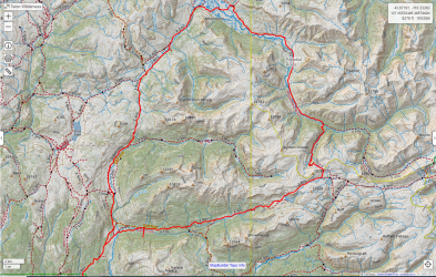
I was planning on taking a 6-7 day backpacking trip in the Teton Wilderness in early July. July 6-12. I had a few questions regarding it and wanted to get input from people who are more familiar with the area. My route is a counter clockwise loop starting and ending from the Turpin Meadows Campground. I would hike north along the CDT before turning east along the Soda Fork Trail. I would continue heading east past Crater Lake stopping short of Ferry Lake. I wanted to drop down into the Woodard Canyon and continue along to the Yellowstone River. From the Yellowstone River I wanted to hike north towards Hawks Rest. From Hawks Rest I was going to turn southwest along the Atlantic/Pacific creek trail through Two Ocean Pass and continue south back towards the Turpin Meadows Campground. I've attached a picture of the route.

#1- Is it even possible? I know that the snow has been above average and there will be a lot of water crossings. Part of me thinks its too early in the season and that there is too much snow.
#2- Are there any good campsites that people would recommend along the route I've planned?

When using CalTopo, the mileage came out to 57 miles. I was going to break that up over 6-7 days depending on the input from others. I've never been here before, but have read some awesome trail reports, and I'd rather not rush. I'd like to take my time and enjoy the experience.

Appreciate anybody's input. Thanks.

Stinson
teton wilderness.PNG
 
I was planning on taking a 6-7 day backpacking trip in the Teton Wilderness in early July. July 6-12. I had a few questions regarding it and wanted to get input from people who are more familiar with the area. My route is a counter clockwise loop starting and ending from the Turpin Meadows Campground. I would hike north along the CDT before turning east along the Soda Fork Trail. I would continue heading east past Crater Lake stopping short of Ferry Lake. I wanted to drop down into the Woodard Canyon and continue along to the Yellowstone River. From the Yellowstone River I wanted to hike north towards Hawks Rest. From Hawks Rest I was going to turn southwest along the Atlantic/Pacific creek trail through Two Ocean Pass and continue south back towards the Turpin Meadows Campground. I've attached a picture of the route.
Just looking at the route and timeline makes me think of two things: 1) mud; and 2) bugs. This is one of my favorite areas in the world, but early summer can be tough. Certainly doable, but not as pleasant as it could be. My rule for the Absarokas is generally to stay high (above ~9.5k') as much as possible until the bugs die off and things dry out (somewhat).

Very subjective guidelines I use: (And obviously melt/weather can shift things a bit.)
  1. July - stay as high as possible; bugs down low and the trails can be very muddy.
  2. August - best and worst of both worlds (see 1 and 3); good for extended, mixed routes.
  3. September - best weather, no bugs, less mud; but significantly less water available up high.
Since my favorite sections are higher, I tend to go in mid-late July. Post-Labor Day is great for lower, more relaxed trips.
#1- Is it even possible? I know that the snow has been above average and there will be a lot of water crossings. Part of me thinks its too early in the season and that there is too much snow.
It's early and you'll definitely be running into snow up high and runoff down low. The river crossings will potentially be tricky, but I'd expect them to be doable. I expect your feet (and probably much more) will be very wet from the Yellowstone River all the way through Two Ocean Pass. Bugs will probably be pretty terrible on most of your route - you might get some minor reprieve near Ferry Lake.
#2- Are there any good campsites that people would recommend along the route I've planned?
Avoid meadows; look for large healthy trees with contiguous canopies when you're down low. Up high - if the weather is good - you can find some great open area camping; extra wind up there could do you big favors with the bug pressure. Camping above Crater Lake and around Ferry Lake is pretty good. I'm sure you could find something, but I wouldn't expect to find much good camping (at this time of year) along the Yellowstone River below 8k' feet or along Atlantic Creek. There's some good spots (and large-ish outfitter camps) along the North Buffalo Fork on your route.

Long story short: I like your route, but it's one I would do in September.

But if this is your opportunity, go for it. The southern Absarokas are spectacular and each time of year is unique - just arrive prepared for the conditions. I'll actually be out there shortly after your dates, but we're only spending a few miles below 9k' and >90% over 10k'. (We may overlap very briefly with your route near Ferry Lake.)
 
Last edited:
Thank you for that @TheMountainRabbit. I appreciate your insight. I wish I could do the trip in September but I cant, unfortunately. I'm a school teacher so I have to cram as much hiking as possible into the 8 week summer break window. But yea, mud and bugs, not the most appealing when it comes to backcountry hiking.

Are there any routes that you'd recommend above the 9.5k range? I have an open window from July 5th to the 13th. I'm doing a loop hike in the Heart Lake/Two Ocean Plateau area in YNP starting on the 14th. After that, I'm heading back home.
 
Are there any routes that you'd recommend above the 9.5k range? I have an open window from July 5th to the 13th.
Definitely don't want to discourage you from getting out there - I'll send you a PM later today.

I know all about cramming vacation into the summer window - my wife is a teacher and I've got two school-aged boys. But September is great backpacking for me, since they're all busy! :lol:
 
Any time after 5th aug is better. I usually plan after mid aug if possible, Bugs are not bad after about aug 15... (Depends on your bug tolerance I guess). More chance Sept can see snow .... and hunting season.
 
Definitely don't want to discourage you from getting out there - I'll send you a PM later today.

I know all about cramming vacation into the summer window - my wife is a teacher and I've got two school-aged boys. But September is great backpacking for me, since they're all busy! :lol:

Sounds good. I appreciate it.
 
Now Christopher, love your route. But doing this in July this year after all the snow last winter could be problematic. I have done this route in reverse many a time. Also many a time would get into the Thorofare as early as possible with sometimes even in late May. And here are some thoughts as to this route.

As concerning the Thorofare and with all the snow up high, do think the Thorofare will flood this year easily. I would see big portains of the Thorofare near Hawks Rest be nothing but standing water after just a normal winter. So it be a flooded swamp is a given. One year do think it was 2011 after a huge winter, it was still muddy and flooded even into July.

Then as for mosquitoes, it will be horrendous this year. Do think it was in 2011 after a big winter, when crossing over Two Ocean Pass there were thousands and thousands and thousands of mosquitoes on me at onetime. So expect the bugs

In July there will be still bigtime snow up high ... big snowfall and a cool spring. Probably the high country accessible back in here after Mid July. But talking about the high country ... why Woodard Canyon when you could go a little further with doing Marston Pass and the Upper Yellowstone via the South Fork of the Yellowstone with seeing Younts Peak. It would be totally worth it to add this bit in my opinion.

The stream crossings will be something this year. In my opinion never cross where the trail crosses for the most part because of the horse use. One can always or usually find an easier crossing nearby. Also you could do for this in reverse with first to Two Ocean Pass and Hawks Rest then the Upper Yellowstone. This is how I did it many a time. And longer you can spend, the better. Go For It!
 
Last edited:
Christopher, just some more for you to think about and hope this helps you out.

Yes I would go into this area many a year in May. The earliest I ever made it to Hawks Rest in the Thorofare was on around May 20th, 2001 which was a drought year. But from Turpin Meadows to the Thorofare via the North Fork of the Buffalo is not one major stream crossing. In most years would get back to the Soda Fork Meadows, in around 6 miles in, and linger here for a good long while. Some great campsites here and gorgeous. Then in going in this way, reverse from your plans, not one major stream crossing until the Thorofare. Just the snow or mud, which every spring was around. In crossing the Thorofare, I had my own route across which often times was drier and less mud or water then the trail. And with all the horse use back to Hawks Rest, sometimes a big bog developed in the meadows from the horse use. But would get back here in spring and many a time saw the Yellowstone River come up all the way to near the top of the bank in a normal year. I would just go and let the conditions dictate my choices. And I would also just linger here in the Thorofare. But by July would go up towards Younts Peak. There is not really a major crossing in going up the Upper Yellowstone until the North and South Forks if heading to Younts Peak area up the South Fork. One could easily go up the South Fork, but for real adventure go up the untrailed North Fork and then over to the South Fork's head basin, and then over to Marston Pass. Great Country! But even then in early July in normal years there would be mud and sometimes snow. Have been at times in the head basin of the South Fork near Younts Peak when still lots of snow around, but doable. Lots of bears near Younts Peak and this high country in here. Ferry Lake is Great! There is a campsite with a bear box at it's outlet. Lots of country in here where one could easily get lost on purpose. Both the Soda Fork and the Upper North Buffalo Fork burned some years ago. But the upper North Buffalo Fork was my favorite. There is a beautiful head basin at the head of the Upper North Fork. Easy coming down the Soda Fork. Do think most of this country will be accessible in July but watch out for the stream crossings and be prepared for the bugs for they will be around. But looks like a good route and doable. Now with myself, I would do it in reverse, instead of Woodard Canyon which is steep ... go by Younts Peak instead up the Upper South Fork of the Yellowstone, and would give yourself enough time - up to two weeks maybe to really see and enjoy it all.

Hope this helps you! Wishing You the Very Best!
 
Last edited:
In July there will be still bigtime snow up high ... big snowfall and a cool spring. Probably the high country accessible back in here after Mid July. But talking about the high country ... why Woodard Canyon when you could go a little further with doing Marston Pass and the Upper Yellowstone via the South Fork of the Yellowstone with seeing Younts Peak. It would be totally worth it to add this bit in my opinion.

But by July would go up towards Younts Peak. There is not really a major crossing in going up the Upper Yellowstone until the North and South Forks if heading to Younts Peak area up the South Fork. One could easily go up the South Fork, but for real adventure go up the untrailed North Fork and then over to the South Fork's head basin, and then over to Marston Pass. Great Country!

Thank you for that! So even with it being above average snow, it'll still be possible to hike. I just need to be prepared for bugs, mud, and some overall wet conditions depending on where I'm at. If thats the case, I think I can do that. If I had the option, I'd wait until August or September but I don't. My timeline is dictating my options on when and where I can go. Its an area I'd really like to see and I'm not sure when the opportunity will present itself again. So if that's the conditions I have to face, so be it.

I do appreciate you mentioning Younts Peak and the South Fork of Yellowstone. But with that, would Marston Pass be feasible or will there be too much snow? Especially with it being an above average year.
 
Do think that July 6 to 12 or so, might be too early considering the kind of winter we had. But after the middle part of July do think it would be possible. Some depends on the weather we have between now and then. But thinking rationally and seeing how it was in past years, might better in my opinion after Mid July. But this is only April and many things are in play. When I went, I just would let the conditions and everything dictate the choices. But also this country will always be here rather the conditions will be right this year for you or not. But when one is around Younts Peak, one is a long ways from everything and if something happens not much help nearby. But such awesome and wild country! Just my two cents worth. Wishing You the Best!
 
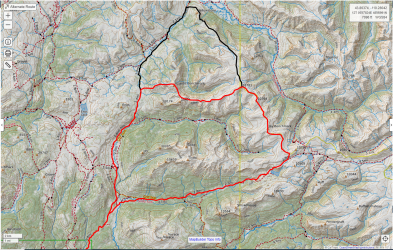
@Kmatjhwy , or anybody else, what do you think of the two routes in the photo? The solid red is one option, the black would be another. With both routes, I start from Turpin Meadows Campground taking the Soda Fork up past Crater Lake and then turning north. The red option would be shorter, the black would have me hike down Yellowstone Point and then south along the Atlantic/Pacific Creek trail towards Turpin Meadows.

I'm thinking the Atlantic/Pacific Creek near the Yellowstone Point area might be marshy and wet. If that's the case, I'd follow the solid red route. Both would allow me to get up high and hopefully, avoid some mud and bugs.

Appreciate your insight!

Alternate Route.PNG
 
Christopher, Hi Again! Now have been all over the area in the photo. At times have hiked here along the Continental Divide from the head basin of the North Buffalo Fork to Yellowstone Point. Have camped in the head basin of the North Buffalo Fork on various occasions and absolutely loved it! At times had some close to very close Grizzly Bear encounters here also. When here would always make an effort to climb Jay Peak, right to the north and at times going all day along this ridge. At times hiked and camped along this untrailed Continental Divide Ridge in here. Not many people get in here and it is wild as everything.

Now personally I would either hike up the North Buffalo all the way or go over from the Soda Fork. Now one can easily get over to the head basin of the North Buffalo Fork from the Soda Fork Drainage. Once one gets to the top above Crater Lake, there will be a very low ridge to the north. Here right on the very east end near the cliffs is or used to be an old route over to the basin of the North Fork. Then once on top easy to get down into the head basin. There is also an old route from the head basin of the North Fork to the head basin of Woodard Canyon also which have used. It has been a few years now but probably these routes are still usable.

Now going up along this ridge is extremely gorgeous with ups and downs but nothing too difficult. The views are awesome! The view from Jay Peak or Point up the Yellowstone with Younts Peak at the head here is absolutely gorgeous! Love It! Remember also being on Tri County Point on this ridge many years ago in 1988. Tri County Point is that place where the three counties meet near Tri County Lake. Yes here one is on the ridge looking down on Tri County Lake below in it's mountain cirque basin. It is little ups and downs, gorgeous mountain basins nearby, gorgeous views, and tremendous wild country. Here would see various Grizzlies around and about, nice herds of Elk about, Eagles flying in the sky around, and not another soul or human nearby. Loved It!!!!

Then have hiked north and camped in a secluded spot on top of the ridge somewhere in the middle of the black line. Camped here for some days and day hiked all over the region. Awesome views from up here down to the Thorofare and the Yellowstone River below. I also climbed that sub Peak here, the sub Peak that juts out toward the Upper Yellowstone River, with Castle Creek far below. Nice little basin here near this sub Peak. Nice Nice alpine basins all along in here with such awesome views with no other humans around. But Grizzly sign all over the place up here also bigtime. Kinda like going back in time several hundred years. Here on this ridge is a small lake or pond which drains on down the Senecio Creek Drainage. Near here is a route used by hunters in the fall which goes on down to Atlantic Creek. Also there are some huge cliffs here with nice views down to the Thorofare. North of these cliffs on the ridge top is a place where the trees were decimated and the dead trees lying on top of one another for some feet. Here between the cliffs and Yellowstone Point. Remember being on the cliffs and scanning everything below. Saw a cave wayyy away from everything with a big Bull Elk at the mouth of the cave.

But when on top here I came down the Jay Creek Drainage from the top. One can hike down easily to the trees. Here down one has to watch yourself for help would not be coming for no one gets much into upper Jay Creek. Trees that had died had fallen over so making the way down slowly, to the Jay Creek absolutely gorgeous meadows. This Upper Jay Creek was always be cascading down with the deep forest and the cliffs on either side. An old route or outfitter trail comes up to the Jay Creek Meadows, located around where the bend is on Jay Creek and on down the Drainage abit. A good route and an absolutely awesome place to camp. Love Jay Creek Meadows!!!! But I slowly came down Jay Creek, absolutely doable, to the meadows where I camped, and then on out and down the outfitter trail to Atlantic Creek.

But Yes have hiked this remote Contiinental Divide Ridge in here and absolutely wild and gorgeous. Again lots of Grizzlies in here and truly wild! Absolutely Loved It! It is truly a great place. Hope this helps you out. Best to you!
 
Last edited:
Looks good. Later is better.

Have a route in my papers almost identical, if you follow th black.... comprises of 5 nights. Your red dropping off of Atlantic benchmark is partially burned and black coming off Yellowstone point is burned...... deadfall to step over, but doable. Soda fork has a lot of burned but is trailed. You could push out a little more (5 miles) to go by Ferry lk.
 
Basic question: I cannot find a paper map of this area of Teton Wilderness (Younts Peak...) Can one of you give me a suggestion? Thanks a lot
W
 
Print off of caltopo
 
Similar threads
Thread starter Title Forum Replies Date
Bob Teton Wilderness July 2024 Trip Planning 38
TractorDoc Yellowstone's Thorofare and the Teton Wilderness 08/09/2023 - 08/18/2023 Part Nine / Day Nine + Ten! Backpacking 20
TractorDoc Yellowstone's Thorofare and the Teton Wilderness 08/09/2023 - 08/18/2023 Part Eight / Day Eight Backpacking 14
TractorDoc Yellowstone's Thorofare and the Teton Wilderness 08/09/2023 - 08/18/2023 Part Seven / Day Seven Backpacking 13
TractorDoc Yellowstone's Thorofare and the Teton Wilderness 08/09/2023 - 08/18/2023 Part Six / Day Six Backpacking 28
TractorDoc Yellowstone's Thorofare and the Teton Wilderness 08/09/2023 - 08/18/2023 Part Five / Day Five Backpacking 16
TractorDoc Yellowstone's Thorofare and the Teton Wilderness 08/09/2023 - 08/18/2023 Part Four / Day Four Backpacking 15
TractorDoc Yellowstone's Thorofare and the Teton Wilderness 08/09/2023 - 08/18/2023 Part Three / Day Three Backpacking 10
TractorDoc Yellowstone's Thorofare and the Teton Wilderness 08/09/2023 - 08/18/2023 -- Part Two / Day Two Backpacking 6
TractorDoc Yellowstone's Thorofare and the Teton Wilderness 08/09/2023 - 08/18/2023 --Part One / Day One Backpacking 10
TheMountainRabbit Southern Absaroka & Thorofare Mountain (Teton/Washakie Wilderness) - July 2023 Backpacking 23
J Pacific Creek or North Buffalo Fork? Teton Wilderness, Thorofare ,etc. Trip Planning 10
Bob Teton Wilderness Trip Planning 2
W Paper map for Teton Wilderness (Younts Peak) Gear 4
F 12 days in Wyoming's Teton Wilderness, part 9 of 9, 7-29 & 30, /2022 Backpacking 5
F 12 days in Wyoming's Teton Wilderness, part 8 of 9, 7/28/2022 Backpacking 5
F 12 days in Wyoming's Teton Wilderness, part 7 of 9, July 26-27, 2022 Backpacking 13
F 12 days in Wyoming's Teton Wilderness, part 6, 7/25/2022 Backpacking 17
F 12 days in Wyoming's Teton Wilderness, part 5 of 9, 7/23-24, 2022 Backpacking 10
F 12 days in Wyoming's Teton Wilderness, part 4 of 9, 7/22, 2022 Backpacking 4
F 12 days in Wyoming's Teton Wilderness, part 3 of 9, 7/20-21, 2022 Backpacking 2
F 12 days in Wyoming's Teton Wilderness, part 2, 7/19/2022 Backpacking 4
F 12 days in Wyoming's Teton Wilderness, part 1, 7/15-18, 2022 Backpacking 13
scatman Pacific Creek, Moss Lake and Gravel Lake - Teton Wilderness - October 7, 2022 Backpacking 32
scatman Teton Wilderness Loop - August 6, 2022 Backpacking 27
Bob Teton Wilderness - 50 miles of High Country - Aug 2022 Backpacking 45
TheMountainRabbit Younts Peak (Teton/Washakie Wilderness) - July 2022 Backpacking 22
F Teton Wilderness, late July 2022 Trip Planning 6
J Teton Wilderness during Hunting Season Trip Planning 6
marquis20 Day 1: Grand Teton Wilderness and Black Canyon of the Yellowstone - June 2021 Backpacking 0
Mikjik86 4 Days Backpacking Grand Teton Wilderness/Teton Crest Trail - Wyoming, July, 2021 Backpacking 0
TeamJenkins17 2022 Teton Wilderness/Shoshone National Forest Trip Trip Planning 0
TheMountainRabbit Southern Absaroka Loop (Teton/Washakie Wilderness) - August 2021 Backpacking 8
D Backpacking Advice in the Winds, Teton Wilderness and the Washakie Wilderness Trip Planning 8
TeamJenkins17 Fox Park-Teton Wilderness Trip Backpacking 6
Jackson A Fall Foray into the Teton Wilderness Backpacking 13
scatman Whetstone Creek, Teton Wilderness - October 11-14, 2019 Backpacking 19
TeamJenkins17 Fox Park Patrol Cabin-Teton Wilderness Trip Planning 1
TeamJenkins17 Thorofare/Teton Wilderness Trip Trip Planning 12
TeamJenkins17 Teton Wilderness July 2019 Backpacking 5
TeamJenkins17 Teton Wilderness Trip Planning 3
TeamJenkins17 Teton Wilderness Trip Planning 6
TeamJenkins17 Teton Wilderness Guide Books Trip Planning 6
TeamJenkins17 Teton Wilderness Info Trip Planning 10
TeamJenkins17 Teton Wilderness Noobs: Introduce yourself! 4
N FL hiker who travels to Teton Wilderness area frequently. Noobs: Introduce yourself! 3
Brian Skibbe Teton Wilderness, GTNP, Jackson Hole 2017 Hiking & Camping 8
scatman Lava Creek, Teton Wilderness - October 6, 2017 Backpacking 25
Brian Skibbe Camping/hiking teton wilderness 06/24-06/29 Meet Up (Members Only) 3
Brian Skibbe 8+ day backpacking trip in the Teton wilderness in May/June. Hunting(small game)/fishing possible? Trip Planning 29

Similar threads

Back
Top