pstm13
Auribus Teneo Lupum
- Joined
- Dec 27, 2012
- Messages
- 572
I usually do at least one multi-day backpacking trip with my wife and a friend or two. This year turned out to be a little different. After making the Teton Crest Trail reservations my wife and I found out that we were expecting twins in October. With this in mind she, of course, would not be able to make the trip. So I did the right thing and explain to her that I would be going anyway and would call her from the first spot I could get cell service which would most likely be Hurricane Pass. Just after making the reservations I got a call from a ranger making sure that I would have an ice axe because there were steep snow fields on the east side of Paint Brush Divide. Luckily, upon arrival at the Moose Ranger Station were were updated on the trail conditions and there would be some snow but nothing that would require an ice axe. In short, there were three of us in the group that planned to hike 35-40 miles along the Teton Crest Trail for 5 days. We would enter the trail via the Teton Village tram and exit at Leigh/String Lake. Thanks to some great advice from BCP members I changed my reservation from Death Canyon to Death Canyon Shelf for our first night at the ranger station. We also watched the obligatory safety video and obtained bear canisters. I opted for the smaller bear canister and regretted it later because I was forced to shove several items in the canisters of other members of the group for the first two days.

After dropping my car off at the String/Leigh Lake trail head parking lot (very easy to find and park for free) we doubled back and drove down that rough road to Teton Village. Upon arrival at Teton Village we tried to find a place to park. We pulled into the fenced lot directly in front of the Mangy Moose Hotel and tram ticket counter to ask the booth attendant for advice. As we did he greeted us and said that we could park for free as long as we wanted. After parking in the fenced area we walked the short distance to the tram ticket counter, forked out the $37 per ticket and headed up the mountain. The air was crisp and cool at 10,450 feet. The sky was clear and blue with a few cotton ball like clouds in the air.


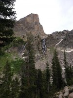
The hike down the back of the ridge was steep and not the best marked trail at the beginning. I found myself checking my GPS several times to make sure we were headed in the right direction. As we descended the trail switched back several times through thick forest. We didn't see any other hikers on the trail for several hours. At times the view opened up and we could see across the valley to the area around Marion Lake. The trail took us west and then turned north toward Marion Lake which sits at the base of some incredible cliff formations. I regret not taking any pictures. We only covered 6 miles but there was a significant amount of elevation gain and loss as we crossed several ridges. If I were to do this again I would probably try to make camp closer to Marion Lake rather than push on to the Death Canyon Shelf.
After an extended break we proceeded on heading north up yet another ridge toward Fox Creek Pass. While hiking up to the pass a storm front rolled in and it began to rain with some small hail stones. The temperature dropped to the mid 50's so it made hiking in rain gear a little more bearable. We hiked up the 500 foot rise to the pass and moved below Fossil Mountain to the shelf.

We pitched our tents in the rain on the edge of a steep drop/cliff that wet down to the floor of the canyon. I was concerned about the wind but it was never an issue while camped there. We cooked dinner in the rocks on the other side of the stream near our camp and went to bed. If found some items that belonged in the "bear bucket" so I got out of my tent and was surprised and amazed at the sunset. As I fell asleep that night I felt humbled by the remoteness of the location and the rugged terrain. I spent the last 6 months planning the trip and my efforts led me to one if the most beautiful places I could imagine. My body and mind took one a sense of peace and satisfaction that I have only felt a few other times in my life. With that I fell into a deep sleep that lasted all night.


The next morning we awoke, ate breakfast, packed up, and headed toward Sunset Lake via Alaska Basin. We were able to get cell service as we headed into the Basin (Verizon not AT&T). I of course called my wife and told her were were safe and having a great time. She was doing well with the twins.
As we dropped down into Alaska Basin we passed through Sheep Steps and the imposing cliffs. We met several groups traveling the same route. Most were from the mid west and east coast. All were very happy to talk with us.

View attachment 32715
We proceeded through the basin and up the north ridge to Sunrise Lake. We camped on a group of rocks overlooking the lake. That evening I looked down at the lake and a man was standing on a rock doing "The Full Monte." There were several groups of teenagers camped around the lake so I can't imagine there thoughts. The hike to Sunset Lake was only about 5 miles on the 2nd day but I was very tired and just wanted to sleep. I thought about swimming in the lake but was tired and after the nude man on the rock I just took it easy around camp and rinsed out my clothes and organized a few things before going to bed for the night. A member of our group was from India and did a little yoga to pass the time in the evening.

The night was cold and rainy. The morning was no different. I loved watching the clouds move up the valley and obscure the peaks. While breaking camp my hands were wet and numb. I had some leather gloves but they were not waterproof. I would have paid a large sum of money for some good waterproof gloves at that time.


I felt great after a shorter hike the previous day and a good nights sleep. We headed out in the rain and hiked toward Huricaine Pass. There were several false summits but the view help with the disappointment. The wet gear added extra weight to my pack but it didn't bother me. I felt recharged and my rain gear kept me dry and comfortable despite the constant rain and mud on the trail.


 To the rear we could see Alaska Basin and Devil's Staircase. Ahead was the Grand, Table Mountain, and Cascade Canyon below.


We spent our last night at the north Cascade Canyon camp area.


 A large thunderstorm rolled through and dropped a large amount of hail and rain. I enjoyed the sound of the rain on my tent. I was glad that I brought a UL tarp (small Outdoor Products tarp from Wal Mart) to line the inside of my tent. It helped keep everything dry despite the large amount of precipitation. The next morning we packed up our wet gear and headed toward Lake Solitude and Paintbrush Divide. Luckily the sun came out before we left and dried out some of our gear. The trail leading up to Paintbrush Divide at 10,700 feet was very manageable. The wind was strong at the top. I would not want to cross the divide in a storm.


The back side of the divide had a small snow field but didn't require an ice axe.

We originally planned on staying the night at lower Paintbrush but opted to hike out.We could see the lake and wanted a meal that did not come in a bag. We stopped at MacPhail's in Jackson for a burger and loved it.
While hiking between north and south Cascade I heard a distinctive growl coming from a boulder field covered in trees above me. I paused and heard another louder growl. I took the safety clip off my bear spray and moved ahead so that if a bear did charge out of the trees I would be out of its way. I never saw anything but did confirm the growls with another member of the group. So it was either a bear or a teenager that was very close to getting sprayed.
Gear review and thoughts for those planning a similar trip:
The majority of the people I met on the trail were from the mid-west or east coast. So I thought I would add this section for people planning a similar trip.
The trip was actually from the 13th to the 16th and took four days. I would have liked to spend the first night at Marion Lake. We didn't do a lot of side trips. I do wish we diverted at Huricane Pass and took the unofficial trail to Table Mountain but I was unfamiliar with that route at the time. Other people hiked Mt. Meek and liked it but said other side trips like Static Peak with elevations over 11,000 feet had slushy snow fields. During the trip there was water available on every stretch of the trail. My Steri-Pen worked well and had a 1/2 charge after 4 solids days of use but another member of the group had a pump as a back up. I only carried 1 liter of water with me. The cool weather also allowed me to carry less water. My Asolo TPS 520 boots were incredible. I did get one blister due to my odd shaped feet but my feet were always dry and comfortable. My least favorite item was the Backpacker's Pantry egg breakfasts. The Denver omelet was disgusting. It requires you to cook out the water on a skillet as if you were home on a real stove. I could not do this so I was stuck with egg vomit. I am taking the Mountain House breakfast skillets or oatmeal from now on. I love my Optimus Terra stove. It used about 1/2 of an 8 oz can of gas. Another member of group had a Jetboil and loved it. It was a little too much for my style though. My 16 oz pot felt small for a group trip as I found myself boiling water a few times each meal because we needed more than 16 oz. Since this trip I purchased a 32 oz aluminum coffee pot. I used Nixwax on my Gore Tex Paclite jacket and Marmot rain pants that are several years old to keep them from washing out. After long days in the rain the only damp spot on the inside of the jacket or pants was the area covered by my pack. I took a garbage bag lined Kelty Ridgeway 50 L pack with me and took out the frame but regretted it. The size was perfect and the garbage bag inside kept my stuff dry. However, the load was too heavy for it and the seams started ripping out near the waist belt. Another member of the group had a Gregory Baltoro that seemed perfect for the trip. I talked with several people who had Osprey packs that loved them as well. After looking at several packs when I got home I purchased a similar Gregory pack. I also wish I had a set of waterproof gloves like the Marmot Precip. It really sucked putting my gear away every morning with wet numb hands. I used my phone to navigate with the GPS Kit app and take pictures. I downloaded the map before we left. I just put it on airplane mode and only took it off to check our location from time to time. To keep the battery strong I put it in my sleeping bag at night with everything else that had a battery. I was able to use it the entire 4 day trip. It died in the parking lot as we exited the trail. My Mountain Hardwear Hibachi 45 down sleeping bag was great in the damp/wet climate even on the coldest nights. I was concerned but it was warmer than expected. My item with the highest value to cost ratio was my orange (not the green one) Walmart sleeping pad. It weighed 1 lb was comfortable and only cost $30 and packed slightly bigger than a Nalgene bottle. The OP tarp $9 from Walmart also worked great to line the inside of the tent (it's a footprint in good weather and a liner inside during bad weather). My BD Revolt lamp also worked well. I could have recharged it with a battery pack but never needed to do it. Another thing I really liked was the key shaped knife tool (Swiss Tech?). I clipped it to a zipper pull cord on the outside of my pack and used it constantly. I can't remember a time that I used my leatherman.
Featured image for home page:

After dropping my car off at the String/Leigh Lake trail head parking lot (very easy to find and park for free) we doubled back and drove down that rough road to Teton Village. Upon arrival at Teton Village we tried to find a place to park. We pulled into the fenced lot directly in front of the Mangy Moose Hotel and tram ticket counter to ask the booth attendant for advice. As we did he greeted us and said that we could park for free as long as we wanted. After parking in the fenced area we walked the short distance to the tram ticket counter, forked out the $37 per ticket and headed up the mountain. The air was crisp and cool at 10,450 feet. The sky was clear and blue with a few cotton ball like clouds in the air.
The hike down the back of the ridge was steep and not the best marked trail at the beginning. I found myself checking my GPS several times to make sure we were headed in the right direction. As we descended the trail switched back several times through thick forest. We didn't see any other hikers on the trail for several hours. At times the view opened up and we could see across the valley to the area around Marion Lake. The trail took us west and then turned north toward Marion Lake which sits at the base of some incredible cliff formations. I regret not taking any pictures. We only covered 6 miles but there was a significant amount of elevation gain and loss as we crossed several ridges. If I were to do this again I would probably try to make camp closer to Marion Lake rather than push on to the Death Canyon Shelf.
After an extended break we proceeded on heading north up yet another ridge toward Fox Creek Pass. While hiking up to the pass a storm front rolled in and it began to rain with some small hail stones. The temperature dropped to the mid 50's so it made hiking in rain gear a little more bearable. We hiked up the 500 foot rise to the pass and moved below Fossil Mountain to the shelf.
We pitched our tents in the rain on the edge of a steep drop/cliff that wet down to the floor of the canyon. I was concerned about the wind but it was never an issue while camped there. We cooked dinner in the rocks on the other side of the stream near our camp and went to bed. If found some items that belonged in the "bear bucket" so I got out of my tent and was surprised and amazed at the sunset. As I fell asleep that night I felt humbled by the remoteness of the location and the rugged terrain. I spent the last 6 months planning the trip and my efforts led me to one if the most beautiful places I could imagine. My body and mind took one a sense of peace and satisfaction that I have only felt a few other times in my life. With that I fell into a deep sleep that lasted all night.
The next morning we awoke, ate breakfast, packed up, and headed toward Sunset Lake via Alaska Basin. We were able to get cell service as we headed into the Basin (Verizon not AT&T). I of course called my wife and told her were were safe and having a great time. She was doing well with the twins.
As we dropped down into Alaska Basin we passed through Sheep Steps and the imposing cliffs. We met several groups traveling the same route. Most were from the mid west and east coast. All were very happy to talk with us.
View attachment 32715
We proceeded through the basin and up the north ridge to Sunrise Lake. We camped on a group of rocks overlooking the lake. That evening I looked down at the lake and a man was standing on a rock doing "The Full Monte." There were several groups of teenagers camped around the lake so I can't imagine there thoughts. The hike to Sunset Lake was only about 5 miles on the 2nd day but I was very tired and just wanted to sleep. I thought about swimming in the lake but was tired and after the nude man on the rock I just took it easy around camp and rinsed out my clothes and organized a few things before going to bed for the night. A member of our group was from India and did a little yoga to pass the time in the evening.
The night was cold and rainy. The morning was no different. I loved watching the clouds move up the valley and obscure the peaks. While breaking camp my hands were wet and numb. I had some leather gloves but they were not waterproof. I would have paid a large sum of money for some good waterproof gloves at that time.
I felt great after a shorter hike the previous day and a good nights sleep. We headed out in the rain and hiked toward Huricaine Pass. There were several false summits but the view help with the disappointment. The wet gear added extra weight to my pack but it didn't bother me. I felt recharged and my rain gear kept me dry and comfortable despite the constant rain and mud on the trail.
To the rear we could see Alaska Basin and Devil's Staircase. Ahead was the Grand, Table Mountain, and Cascade Canyon below. We spent our last night at the north Cascade Canyon camp area.
A large thunderstorm rolled through and dropped a large amount of hail and rain. I enjoyed the sound of the rain on my tent. I was glad that I brought a UL tarp (small Outdoor Products tarp from Wal Mart) to line the inside of my tent. It helped keep everything dry despite the large amount of precipitation. The next morning we packed up our wet gear and headed toward Lake Solitude and Paintbrush Divide. Luckily the sun came out before we left and dried out some of our gear. The trail leading up to Paintbrush Divide at 10,700 feet was very manageable. The wind was strong at the top. I would not want to cross the divide in a storm. The back side of the divide had a small snow field but didn't require an ice axe.
We originally planned on staying the night at lower Paintbrush but opted to hike out.We could see the lake and wanted a meal that did not come in a bag. We stopped at MacPhail's in Jackson for a burger and loved it.
While hiking between north and south Cascade I heard a distinctive growl coming from a boulder field covered in trees above me. I paused and heard another louder growl. I took the safety clip off my bear spray and moved ahead so that if a bear did charge out of the trees I would be out of its way. I never saw anything but did confirm the growls with another member of the group. So it was either a bear or a teenager that was very close to getting sprayed.
Gear review and thoughts for those planning a similar trip:
The majority of the people I met on the trail were from the mid-west or east coast. So I thought I would add this section for people planning a similar trip.
The trip was actually from the 13th to the 16th and took four days. I would have liked to spend the first night at Marion Lake. We didn't do a lot of side trips. I do wish we diverted at Huricane Pass and took the unofficial trail to Table Mountain but I was unfamiliar with that route at the time. Other people hiked Mt. Meek and liked it but said other side trips like Static Peak with elevations over 11,000 feet had slushy snow fields. During the trip there was water available on every stretch of the trail. My Steri-Pen worked well and had a 1/2 charge after 4 solids days of use but another member of the group had a pump as a back up. I only carried 1 liter of water with me. The cool weather also allowed me to carry less water. My Asolo TPS 520 boots were incredible. I did get one blister due to my odd shaped feet but my feet were always dry and comfortable. My least favorite item was the Backpacker's Pantry egg breakfasts. The Denver omelet was disgusting. It requires you to cook out the water on a skillet as if you were home on a real stove. I could not do this so I was stuck with egg vomit. I am taking the Mountain House breakfast skillets or oatmeal from now on. I love my Optimus Terra stove. It used about 1/2 of an 8 oz can of gas. Another member of group had a Jetboil and loved it. It was a little too much for my style though. My 16 oz pot felt small for a group trip as I found myself boiling water a few times each meal because we needed more than 16 oz. Since this trip I purchased a 32 oz aluminum coffee pot. I used Nixwax on my Gore Tex Paclite jacket and Marmot rain pants that are several years old to keep them from washing out. After long days in the rain the only damp spot on the inside of the jacket or pants was the area covered by my pack. I took a garbage bag lined Kelty Ridgeway 50 L pack with me and took out the frame but regretted it. The size was perfect and the garbage bag inside kept my stuff dry. However, the load was too heavy for it and the seams started ripping out near the waist belt. Another member of the group had a Gregory Baltoro that seemed perfect for the trip. I talked with several people who had Osprey packs that loved them as well. After looking at several packs when I got home I purchased a similar Gregory pack. I also wish I had a set of waterproof gloves like the Marmot Precip. It really sucked putting my gear away every morning with wet numb hands. I used my phone to navigate with the GPS Kit app and take pictures. I downloaded the map before we left. I just put it on airplane mode and only took it off to check our location from time to time. To keep the battery strong I put it in my sleeping bag at night with everything else that had a battery. I was able to use it the entire 4 day trip. It died in the parking lot as we exited the trail. My Mountain Hardwear Hibachi 45 down sleeping bag was great in the damp/wet climate even on the coldest nights. I was concerned but it was warmer than expected. My item with the highest value to cost ratio was my orange (not the green one) Walmart sleeping pad. It weighed 1 lb was comfortable and only cost $30 and packed slightly bigger than a Nalgene bottle. The OP tarp $9 from Walmart also worked great to line the inside of the tent (it's a footprint in good weather and a liner inside during bad weather). My BD Revolt lamp also worked well. I could have recharged it with a battery pack but never needed to do it. Another thing I really liked was the key shaped knife tool (Swiss Tech?). I clipped it to a zipper pull cord on the outside of my pack and used it constantly. I can't remember a time that I used my leatherman.
Featured image for home page:
Attachments
-
 IMG_2187.JPG128.2 KB · Views: 101
 -
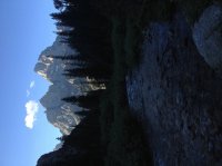 image.jpg80.2 KB · Views: 353
 -
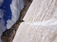 image.jpg109.7 KB · Views: 354
 -
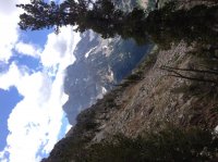 image.jpg134.4 KB · Views: 87
 -
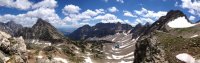 image.jpg77 KB · Views: 74
 -
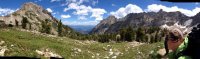 image.jpg73.6 KB · Views: 80
 -
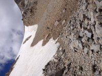 image.jpg171.9 KB · Views: 85
 -
 image.jpg98.7 KB · Views: 82
 -
 image.jpg147.9 KB · Views: 89
 -
 image.jpg138.6 KB · Views: 87
Last edited:
