wabenho
Member
- Joined
- Sep 18, 2017
- Messages
- 138
I realize there is already a good deal of info on the web about the Teton Crest Trail including a few great trip reports on BCP, but in the interest of contributing, I would like to share my experience on the TCT. Maybe a bit of this info will help someone in future planning. If nothing else, a few of the pics aren’t too bad to look at.
My brother-in-law is my usual backpacking partner and this trip has been on our radar for a while, so we decided to try for permits in 2020. Our trip planning started back in early January when we obtained permits on the first day they were available via the web. I was able to secure Upper Granite, South Fork Cascade, and Upper Paintbrush camp zones. We also planned to spend a night in Alaska Basin which is on National Forest land and no permit is required. Not the exact itinerary I hoped for, but it would work.
As you all know, in the spring of 2020, everything changed due to COVID. Our trip became uncertain for a while as some National Parks were cancelling backcountry permit reservations. Grand Teton National Park never did cancel permits (as far as I know) and as summer approached, they seemed to be continuing operations in a somewhat normal fashion.
My brother-in-law is a nurse in the Army and, unfortunately, as August approached, he was deployed to Houston to help care for COVID patients in that area. This meant that he would not be receiving leave for the trip and he had to bow out. After considering my options for some time, I decided that I would do the trip solo. Solo is really a relative term here as anyone who has done the TCT in August can tell you, one is never really alone.
Enough backstory. Two days before my first night in the backcountry, I drove up to Grand Teton National Park.

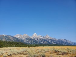
I arrived early enough in the afternoon, that I decided to take a quick day hike. I found a parking spot at Lupine Meadows and headed up the trail. Here are a few pics from that hike:


Remember when I said that the itinerary, I reserved in January was not my ideal trip? This is the reason I arrived in the park two days early. The permit desk allows you to pick up permits the day before your first night in the backcountry. I was hoping to switch a couple of my permits, so I wanted to be one of the first in line the next morning.
So, the next day, I awoke early, grabbed a breakfast burrito from the Creekside Market and headed up to the visitor center at Moose. I arrived at 6:20 AM and was third in line. I enjoyed my burrito, talked with the others in line and read my book. A couple of rain showers passed, but we were waiting in a covered porch area, so it was nice. By 9:00 AM, when the rangers opened the permit desk, there were probably 30-40 people in line. I think this was busier that normal because it was a Thursday morning and folks were looking for permits for the weekend.
Three rangers were working at the desk so being third in line was basically the same as being first or second. I was able to successfully switch my permits to my preferred itinerary. My trip now looked like this: Marion Lake – Alaska Basin – South Fork Cascade Canyon – Holly Lake. In addition to picking up my permits, I was able to borrow a bear container to use. They have two sizes and there is no additional cost for using one of the Park’s containers.
Now that I had my permits, it was time for some fun and then some logistics. I drove to Teton Village and rented a mountain bike. I spent a couple of hours riding the trails at Jackson Hole Mountain Resort and had a great time.
As time passed into the afternoon, it was time to work on logistics. I previously booked a night at the Teton Village Hostel. Due to COVID, it wasn’t being operated as a hostel and I had a 4-bunk room to myself. It was the cheapest option I could find in Teton Village. I spent the next hour or so packing my food into the bear canister and double checking my backpack. After that was all squared away, I checked into the hostel, dropped my backpacking pack and a small duffel bag with a few items I wanted for the evening and next morning.
Next, I loaded the rented mountain bike on the bike rack of my car and drove to the String Lake trailhead. In addition to hikers, String Lake is popular with sunbathing families, kayakers and paddleboarders. As it was a warm afternoon, I had to circle the lot for a few minutes until a spot opened. I eventually found one, unloaded the bike and started pedaling back toward Teton Village.
It was a very nice ride along the one-way road to Jenny Lake base area, then a paved path between Jenny Lake and Moose, and the final miles along the Moose-Wilson road. Along this last stretch I saw a cow moose and a black bear. I took pictures of both, but wont post them here. They are the kind of pics where you see a big wildlife induced traffic jam and an annoyed looking animal in the background. Not too flattering for anyone involved. In all, it was about a 20-mile ride, mostly downhill, on paved surfaces (except for a short stretch of Moose-Wilson road that is unpaved).


Once back at Teton Village, I returned the rental bike, showered, changed, and ordered a burger to go from the Mangy Moose which I ate on a picnic table outside the hostel. Then off to the room to rest up for the next few days of adventure.
Day 1 – Teton Village to Marion Lake via Granite Canyon
I awoke early and grabbed some breakfast to-go from the Mangy Moose. As I ate in my room, I made final preparations and checked the weather one last time before leaving cell service. The forecast, which once looked stellar, was now calling for a storm near the end of my trip. Not ideal, but nothing to worry too much about. I then checked out of the hostel and left the small duffel bag of items I did not need for the hike with the front desk. They will hold a small bag for the duration of your hike, which is a nice service for hikers.
There are multiple ways to start the TCT. I believe the orthodox way is to begin just off highway 22, near Teton Pass and take the Phillips Pass trail. Due to logistics, I was starting at Teton Village. Most years, a popular way to begin the TCT from the Village is to take the tram. When it is running, “Big Red” the Jackson Hole Mountain Resort Tram, can save hikers a few miles and a couple thousand feet of elevation gain. It was not running during the summer of 2020 due to maintenance and repairs. Some 2020 hikers were choosing to start by using the Bridger Gondola, which is the same idea as the tram, it just doesn’t take you quite as far up Rendezvous Mountain.
I elected to take Granite Canyon which is accessed from Teton Village by hiking north for a couple of miles along the Valley Trail. After joining the Granite Canyon trail, I began climbing along a nice creek. The lower elevations of the trail are pine forested with fern carpets. As you climb higher, the pines thin and move to the north slopes and the ferns are replaced with wildflower meadows. Unfortunately, I was outside peak wildflower season along most of the trail, but it was still beautiful.
After about 10 miles and 3000 feet of climbing I arrived at Marion Lake. Marion Lake is a small lake nestled at the base of a cliff that is not quite a cirque.

I was the first camper to arrive for the evening, so I chose one of the 3 sites and set up camp. After, I walked down to the lake and explored for a bit. As I explored, other campers began to arrive, including a volunteer ranger. Apparently, there was a bit of a mix up, because eventually 4 groups arrived, all with seemingly valid permits. After some discussion, I invited a group of 2 who were using one tent to share my site. Each site has 2 tent pads and I was only using one. I had no real expectation of solitude anyway and the guys were cool. Everyone seemed OK with this, except for the volunteer ranger who was mildly irritated with the permit desk rangers.
If you ever find yourself camped at Marion Lake, or even if you are just passing through, don’t forget to walk over the hill east of the campsites and take in the view down Granite Canyon.

Once the campsite situation was handled, I walked down to the lake with my new friends to prepare dinner. While eating and chatting two young ladies walked down to the lake, stripped off and hopped in. I’m pretty sure they knew we were there, I guess they just weren’t shy. They swam for a short time, hopped out, redressed, and continued down the trail. I know there is a whole thread on this forum devoted to this kind of thing, so I guess we can add one more to that list.
After dinner we chatted a bit more and then settled in for the night. One of my luxury items on a backpacking trip, especially when solo, is a good book. This trip I read Teewinot, by Jack Turner. Very specific to the Teton range, but a great book particularly if you are visiting the area.
Day 2 – Marion Lake to Alaska Basin
The next morning, I broke camp, said farewell to the other campers and headed up the hill towards Fox Creek Pass.

At the top of the hill, the trail leaves GTNP for a bit and one can camp there without a permit. You can reach this spot fairly easily in a day and although the elevation is higher and there are fewer trees, there appeared to be a few decent camping spots. It is also along here that you get your first glimpses of the Grand Teton and the Cathedral Group.


After working my way along a gentle hill, I crested Fox Creek Pass. From here there is a little closer view of the Teton Range with Death Canyon in the foreground to the east and Death Canyon Shelf to the west.

Death Canyon is hook shaped so as I progressed along the Shelf, I had different perspectives of the canyon.

Near the north end of the Shelf, you are able to look straight down the east/west part of Death Canyon.

After crossing Death Canyon Shelf, I made the short climb to the top of Mount Meek Pass. From here I started to make my way down to Alaska Basin

The decent down the “Sheep Steps” into Alaska Basin is pretty steep. I was happy to be going down instead of up. Alaska Basin is a beautiful place with small tributaries of the South Fork of the Teton River flowing through and small lakes and tarns dispersed between rock outcroppings and boulders. Opposed to the other drainages I had encountered and would encounter on this trip, Alaska basin is on the west side of the Tetons, so the water here flows west to the Teton River in Idaho.

It was a Saturday afternoon and the Basin was busy with backpackers. Alaska Basin lies outside Grand Teton National Park and no permit is required to camp here overnight. That does not mean the area is without rules though. I watched a ranger make his way through several camps. He even asked one group to move. I assume he felt they were camped too close to one of the lakes, but I could not hear the conversation.
With most of the activity centered around the lakes, I found a spot on the outskirts near a stand of pines and rock outcropping that overlooked a meadow where one of the small creeks flowed. I set up camp and watched the meadow for a while. It seemed like the perfect place to see wildlife, but I think with the bustle of the Basin, most critters found other spots to spend the weekend. In addition to the meadow, my camp for the evening had a great view of the backside of Buck Mountain.

Despite the number of folks in the Basin, I enjoyed a very peaceful evening and night.
Day 3 – Alaska Basin to South Fork Cascade Canyon
I awoke early the next morning, enjoyed breakfast overlooking the meadow (still no visible wildlife), packed up camp, and headed up the trail. From the main area of Alaska Basin, the trail climbs for about a mile over the hill to Sunset Lake.

This is a beautiful little lake that has spectacular views all around, especially to the west. I passed through in the morning, but it was obvious why they call it Sunset Lake when you look to the west. Sunset Lake is still part of the Jedediah Smith Wilderness Area outside the National Park and one can camp her without obtaining a permit. There appeared to be several nice camps near Sunset Lake, most of them occupied the night before.
After passing Sunset Lake, I began my climb up toward Hurricane Pass. The views looking back toward Sunset Lake and Alaska Basin were a nice reward as I climbed in stages.

Climbing to Hurricane Pass from Alaska Basin is about 1200’ over approx. 3 miles. Hurricane Pass sits at 10550' and marks the 2nd highest point along my TCT hike. Once at the top, I was once again within the borders of the National Park. Hurricane Pass was true to its name this morning as it was quite windy.
As I neared the crest of the pass the Cathedral Group re-appeared.

A little further down the South Fork Cascade side of the pass, Schoolroom Glacier comes into view with its crater-pool resting beneath.


For me, this was the best section of the TCT. As I hiked down upper South Fork Cascade, I could not stop snapping pics.


The walk down South Fork Cascade felt like the quintessential American National Park backcountry experience. Pines, meadows, cascading creeks, soaring granite towers. It was so beautiful and for most of the day I reveled in the exact experience I was hoping to have from the time I began planning the trip.


The last weather report that I received at the beginning of the trip called for rain on my day 4. I was uncertain if this forecast was holding or if it had changed so I worked my way down to the lower portion of the camp zone to better position myself to get over Paintbrush Divide earlier the next day.
After setting up camp, I walked down to the confluence of the South Fork and North Fork Cascade trails. Cascade Canyon is a popular day hike for Grand Teton visitors, and I was hoping to catch an updated weather report from someone. It was later in the day, so many day hikers had already finished up and headed back to Jackson for dinner. I did encounter a few groups, but none had paid much attention to the forecast.
I returned to camp for dinner. There is a bear box that can be shared by the 3 or 4 campsites in the lower section of South Fork, but a tree has fallen near the box, and partially obstructed the door. It is still usable, but not super convenient. I still opted to use it for the night.
After dinner I spent the evening watching the sunset against the peaks and listening to the cascading creeks near camp.

Day 4 – South Fork Cascade Canyon toHolly Lake String Lake Trailhead
I half expected to wake up to rain on the morning of Day 4, but I awoke to dry and mild conditions. My first order of the day was to evaluate the weather. If it didn’t look good, I knew that I could retreat down Cascade Canyon and around Jenny Lake to my car at the String Lake TH. If it looked OK, I would proceed as planned up North Fork Cascade Canyon to Lake Solitude and over Paintbrush Divide. Well, the weather neither looked really bad nor really good. I decided to proceed as far as Lake Solitude and re-evaluate at that point.


I also saw a large bull moose in North Fork, but he was at a distance where none of the pictures turned out.
As I arrived at Lake Solitude it began to snow lightly.

I paused at the lake to consider my options. I could still go back the way I came and down Cascade Canyon to my car. As I paused a couple other groups passed me and pressed on towards the Divide. I decided that I would venture further, still knowing that I could turn back if needed. Also, I knew that I would not be alone in my trek so I pulled out my raincoat, gloves and warm hat and then headed up the trail.

The weather was really not too bad along this stretch. Yes, it was a little cold and still snowing lightly, but hiking up the steep trail kept me warm and the snow never really stuck. The really disappointing aspect of this day was the fact that I was missing out on the incredible views. During my planning, I saw so many beautiful pictures from this section of trail, I was really bummed to be missing out. I eventually crossed the Divide around noon without incident. Paintbrush Divide would be the highest point of my hike at approx 10700'.

The descent down the Paintbrush Canyon side of the Divide was a little trickier than going up the North Fork Cascade side, but never did it feel unsafe. Eventually I made it to my planned camp for the evening at Holly Lake.

I worked my way around to the designated campsites at Holly Lake to find them somewhat muddy with small puddles building. A mixed rain/snow drizzle was still falling. I passed some hikers who said the precipitation was forecast to continue through the evening and into the night. At that point I decided to continue 6 miles down Paintbrush Canyon to my car at String Lake.
The remainder of the hike was beautiful, just different than what I expected. As I entered the thicker pine forests and fern carpets, the falling rain gave a rain forest type feel to the walk. The views down to Leigh and String Lakes were nice with the misty cloud cover.


I arrived at my car and somewhat discreetly changed into some dryer clothes. There were not many cars in the parking lot due to the weather. I needed to drop off my borrowed bear canister at a ranger station and pick up my duffel bag from Teton Village. As I drove past Jenny Lake, I saw a couple of backpackers trying to hitch a ride. I pulled over and loaded them in. They were a young couple from Austin who had been on the TCT but decided to bail down Cascade Canyon when the weather turned. They waited for me while I returned my bear canister and then I drove them to their car at Granite TH. I then continued to Teton Village to grab my duffel bag and a warm meal.
Overall, it was an awesome trip. I’ll just need to return to try the Cascade/Paintbrush loop on a clear day to see those views. It also would have been nice to adjust my itinerary along the way as I knew the storm was coming, but the options are limited under a permit system. I guess that is a fair trade off, as I would not want all areas of the TCT to be as busy as Alaska Basin was the night I spent there.
My brother-in-law is my usual backpacking partner and this trip has been on our radar for a while, so we decided to try for permits in 2020. Our trip planning started back in early January when we obtained permits on the first day they were available via the web. I was able to secure Upper Granite, South Fork Cascade, and Upper Paintbrush camp zones. We also planned to spend a night in Alaska Basin which is on National Forest land and no permit is required. Not the exact itinerary I hoped for, but it would work.
As you all know, in the spring of 2020, everything changed due to COVID. Our trip became uncertain for a while as some National Parks were cancelling backcountry permit reservations. Grand Teton National Park never did cancel permits (as far as I know) and as summer approached, they seemed to be continuing operations in a somewhat normal fashion.
My brother-in-law is a nurse in the Army and, unfortunately, as August approached, he was deployed to Houston to help care for COVID patients in that area. This meant that he would not be receiving leave for the trip and he had to bow out. After considering my options for some time, I decided that I would do the trip solo. Solo is really a relative term here as anyone who has done the TCT in August can tell you, one is never really alone.
Enough backstory. Two days before my first night in the backcountry, I drove up to Grand Teton National Park.
I arrived early enough in the afternoon, that I decided to take a quick day hike. I found a parking spot at Lupine Meadows and headed up the trail. Here are a few pics from that hike:
Remember when I said that the itinerary, I reserved in January was not my ideal trip? This is the reason I arrived in the park two days early. The permit desk allows you to pick up permits the day before your first night in the backcountry. I was hoping to switch a couple of my permits, so I wanted to be one of the first in line the next morning.
So, the next day, I awoke early, grabbed a breakfast burrito from the Creekside Market and headed up to the visitor center at Moose. I arrived at 6:20 AM and was third in line. I enjoyed my burrito, talked with the others in line and read my book. A couple of rain showers passed, but we were waiting in a covered porch area, so it was nice. By 9:00 AM, when the rangers opened the permit desk, there were probably 30-40 people in line. I think this was busier that normal because it was a Thursday morning and folks were looking for permits for the weekend.
Three rangers were working at the desk so being third in line was basically the same as being first or second. I was able to successfully switch my permits to my preferred itinerary. My trip now looked like this: Marion Lake – Alaska Basin – South Fork Cascade Canyon – Holly Lake. In addition to picking up my permits, I was able to borrow a bear container to use. They have two sizes and there is no additional cost for using one of the Park’s containers.
Now that I had my permits, it was time for some fun and then some logistics. I drove to Teton Village and rented a mountain bike. I spent a couple of hours riding the trails at Jackson Hole Mountain Resort and had a great time.
As time passed into the afternoon, it was time to work on logistics. I previously booked a night at the Teton Village Hostel. Due to COVID, it wasn’t being operated as a hostel and I had a 4-bunk room to myself. It was the cheapest option I could find in Teton Village. I spent the next hour or so packing my food into the bear canister and double checking my backpack. After that was all squared away, I checked into the hostel, dropped my backpacking pack and a small duffel bag with a few items I wanted for the evening and next morning.
Next, I loaded the rented mountain bike on the bike rack of my car and drove to the String Lake trailhead. In addition to hikers, String Lake is popular with sunbathing families, kayakers and paddleboarders. As it was a warm afternoon, I had to circle the lot for a few minutes until a spot opened. I eventually found one, unloaded the bike and started pedaling back toward Teton Village.
It was a very nice ride along the one-way road to Jenny Lake base area, then a paved path between Jenny Lake and Moose, and the final miles along the Moose-Wilson road. Along this last stretch I saw a cow moose and a black bear. I took pictures of both, but wont post them here. They are the kind of pics where you see a big wildlife induced traffic jam and an annoyed looking animal in the background. Not too flattering for anyone involved. In all, it was about a 20-mile ride, mostly downhill, on paved surfaces (except for a short stretch of Moose-Wilson road that is unpaved).
Once back at Teton Village, I returned the rental bike, showered, changed, and ordered a burger to go from the Mangy Moose which I ate on a picnic table outside the hostel. Then off to the room to rest up for the next few days of adventure.
Day 1 – Teton Village to Marion Lake via Granite Canyon
I awoke early and grabbed some breakfast to-go from the Mangy Moose. As I ate in my room, I made final preparations and checked the weather one last time before leaving cell service. The forecast, which once looked stellar, was now calling for a storm near the end of my trip. Not ideal, but nothing to worry too much about. I then checked out of the hostel and left the small duffel bag of items I did not need for the hike with the front desk. They will hold a small bag for the duration of your hike, which is a nice service for hikers.
There are multiple ways to start the TCT. I believe the orthodox way is to begin just off highway 22, near Teton Pass and take the Phillips Pass trail. Due to logistics, I was starting at Teton Village. Most years, a popular way to begin the TCT from the Village is to take the tram. When it is running, “Big Red” the Jackson Hole Mountain Resort Tram, can save hikers a few miles and a couple thousand feet of elevation gain. It was not running during the summer of 2020 due to maintenance and repairs. Some 2020 hikers were choosing to start by using the Bridger Gondola, which is the same idea as the tram, it just doesn’t take you quite as far up Rendezvous Mountain.
I elected to take Granite Canyon which is accessed from Teton Village by hiking north for a couple of miles along the Valley Trail. After joining the Granite Canyon trail, I began climbing along a nice creek. The lower elevations of the trail are pine forested with fern carpets. As you climb higher, the pines thin and move to the north slopes and the ferns are replaced with wildflower meadows. Unfortunately, I was outside peak wildflower season along most of the trail, but it was still beautiful.
After about 10 miles and 3000 feet of climbing I arrived at Marion Lake. Marion Lake is a small lake nestled at the base of a cliff that is not quite a cirque.
I was the first camper to arrive for the evening, so I chose one of the 3 sites and set up camp. After, I walked down to the lake and explored for a bit. As I explored, other campers began to arrive, including a volunteer ranger. Apparently, there was a bit of a mix up, because eventually 4 groups arrived, all with seemingly valid permits. After some discussion, I invited a group of 2 who were using one tent to share my site. Each site has 2 tent pads and I was only using one. I had no real expectation of solitude anyway and the guys were cool. Everyone seemed OK with this, except for the volunteer ranger who was mildly irritated with the permit desk rangers.
If you ever find yourself camped at Marion Lake, or even if you are just passing through, don’t forget to walk over the hill east of the campsites and take in the view down Granite Canyon.
Once the campsite situation was handled, I walked down to the lake with my new friends to prepare dinner. While eating and chatting two young ladies walked down to the lake, stripped off and hopped in. I’m pretty sure they knew we were there, I guess they just weren’t shy. They swam for a short time, hopped out, redressed, and continued down the trail. I know there is a whole thread on this forum devoted to this kind of thing, so I guess we can add one more to that list.
After dinner we chatted a bit more and then settled in for the night. One of my luxury items on a backpacking trip, especially when solo, is a good book. This trip I read Teewinot, by Jack Turner. Very specific to the Teton range, but a great book particularly if you are visiting the area.
Day 2 – Marion Lake to Alaska Basin
The next morning, I broke camp, said farewell to the other campers and headed up the hill towards Fox Creek Pass.
At the top of the hill, the trail leaves GTNP for a bit and one can camp there without a permit. You can reach this spot fairly easily in a day and although the elevation is higher and there are fewer trees, there appeared to be a few decent camping spots. It is also along here that you get your first glimpses of the Grand Teton and the Cathedral Group.
After working my way along a gentle hill, I crested Fox Creek Pass. From here there is a little closer view of the Teton Range with Death Canyon in the foreground to the east and Death Canyon Shelf to the west.
Death Canyon is hook shaped so as I progressed along the Shelf, I had different perspectives of the canyon.
Near the north end of the Shelf, you are able to look straight down the east/west part of Death Canyon.
After crossing Death Canyon Shelf, I made the short climb to the top of Mount Meek Pass. From here I started to make my way down to Alaska Basin
The decent down the “Sheep Steps” into Alaska Basin is pretty steep. I was happy to be going down instead of up. Alaska Basin is a beautiful place with small tributaries of the South Fork of the Teton River flowing through and small lakes and tarns dispersed between rock outcroppings and boulders. Opposed to the other drainages I had encountered and would encounter on this trip, Alaska basin is on the west side of the Tetons, so the water here flows west to the Teton River in Idaho.
It was a Saturday afternoon and the Basin was busy with backpackers. Alaska Basin lies outside Grand Teton National Park and no permit is required to camp here overnight. That does not mean the area is without rules though. I watched a ranger make his way through several camps. He even asked one group to move. I assume he felt they were camped too close to one of the lakes, but I could not hear the conversation.
With most of the activity centered around the lakes, I found a spot on the outskirts near a stand of pines and rock outcropping that overlooked a meadow where one of the small creeks flowed. I set up camp and watched the meadow for a while. It seemed like the perfect place to see wildlife, but I think with the bustle of the Basin, most critters found other spots to spend the weekend. In addition to the meadow, my camp for the evening had a great view of the backside of Buck Mountain.
Despite the number of folks in the Basin, I enjoyed a very peaceful evening and night.
Day 3 – Alaska Basin to South Fork Cascade Canyon
I awoke early the next morning, enjoyed breakfast overlooking the meadow (still no visible wildlife), packed up camp, and headed up the trail. From the main area of Alaska Basin, the trail climbs for about a mile over the hill to Sunset Lake.
This is a beautiful little lake that has spectacular views all around, especially to the west. I passed through in the morning, but it was obvious why they call it Sunset Lake when you look to the west. Sunset Lake is still part of the Jedediah Smith Wilderness Area outside the National Park and one can camp her without obtaining a permit. There appeared to be several nice camps near Sunset Lake, most of them occupied the night before.
After passing Sunset Lake, I began my climb up toward Hurricane Pass. The views looking back toward Sunset Lake and Alaska Basin were a nice reward as I climbed in stages.
Climbing to Hurricane Pass from Alaska Basin is about 1200’ over approx. 3 miles. Hurricane Pass sits at 10550' and marks the 2nd highest point along my TCT hike. Once at the top, I was once again within the borders of the National Park. Hurricane Pass was true to its name this morning as it was quite windy.
As I neared the crest of the pass the Cathedral Group re-appeared.
A little further down the South Fork Cascade side of the pass, Schoolroom Glacier comes into view with its crater-pool resting beneath.
For me, this was the best section of the TCT. As I hiked down upper South Fork Cascade, I could not stop snapping pics.
The walk down South Fork Cascade felt like the quintessential American National Park backcountry experience. Pines, meadows, cascading creeks, soaring granite towers. It was so beautiful and for most of the day I reveled in the exact experience I was hoping to have from the time I began planning the trip.
The last weather report that I received at the beginning of the trip called for rain on my day 4. I was uncertain if this forecast was holding or if it had changed so I worked my way down to the lower portion of the camp zone to better position myself to get over Paintbrush Divide earlier the next day.
After setting up camp, I walked down to the confluence of the South Fork and North Fork Cascade trails. Cascade Canyon is a popular day hike for Grand Teton visitors, and I was hoping to catch an updated weather report from someone. It was later in the day, so many day hikers had already finished up and headed back to Jackson for dinner. I did encounter a few groups, but none had paid much attention to the forecast.
I returned to camp for dinner. There is a bear box that can be shared by the 3 or 4 campsites in the lower section of South Fork, but a tree has fallen near the box, and partially obstructed the door. It is still usable, but not super convenient. I still opted to use it for the night.
After dinner I spent the evening watching the sunset against the peaks and listening to the cascading creeks near camp.
Day 4 – South Fork Cascade Canyon to
I half expected to wake up to rain on the morning of Day 4, but I awoke to dry and mild conditions. My first order of the day was to evaluate the weather. If it didn’t look good, I knew that I could retreat down Cascade Canyon and around Jenny Lake to my car at the String Lake TH. If it looked OK, I would proceed as planned up North Fork Cascade Canyon to Lake Solitude and over Paintbrush Divide. Well, the weather neither looked really bad nor really good. I decided to proceed as far as Lake Solitude and re-evaluate at that point.
I also saw a large bull moose in North Fork, but he was at a distance where none of the pictures turned out.
As I arrived at Lake Solitude it began to snow lightly.
I paused at the lake to consider my options. I could still go back the way I came and down Cascade Canyon to my car. As I paused a couple other groups passed me and pressed on towards the Divide. I decided that I would venture further, still knowing that I could turn back if needed. Also, I knew that I would not be alone in my trek so I pulled out my raincoat, gloves and warm hat and then headed up the trail.
The weather was really not too bad along this stretch. Yes, it was a little cold and still snowing lightly, but hiking up the steep trail kept me warm and the snow never really stuck. The really disappointing aspect of this day was the fact that I was missing out on the incredible views. During my planning, I saw so many beautiful pictures from this section of trail, I was really bummed to be missing out. I eventually crossed the Divide around noon without incident. Paintbrush Divide would be the highest point of my hike at approx 10700'.
The descent down the Paintbrush Canyon side of the Divide was a little trickier than going up the North Fork Cascade side, but never did it feel unsafe. Eventually I made it to my planned camp for the evening at Holly Lake.
I worked my way around to the designated campsites at Holly Lake to find them somewhat muddy with small puddles building. A mixed rain/snow drizzle was still falling. I passed some hikers who said the precipitation was forecast to continue through the evening and into the night. At that point I decided to continue 6 miles down Paintbrush Canyon to my car at String Lake.
The remainder of the hike was beautiful, just different than what I expected. As I entered the thicker pine forests and fern carpets, the falling rain gave a rain forest type feel to the walk. The views down to Leigh and String Lakes were nice with the misty cloud cover.
I arrived at my car and somewhat discreetly changed into some dryer clothes. There were not many cars in the parking lot due to the weather. I needed to drop off my borrowed bear canister at a ranger station and pick up my duffel bag from Teton Village. As I drove past Jenny Lake, I saw a couple of backpackers trying to hitch a ride. I pulled over and loaded them in. They were a young couple from Austin who had been on the TCT but decided to bail down Cascade Canyon when the weather turned. They waited for me while I returned my bear canister and then I drove them to their car at Granite TH. I then continued to Teton Village to grab my duffel bag and a warm meal.
Overall, it was an awesome trip. I’ll just need to return to try the Cascade/Paintbrush loop on a clear day to see those views. It also would have been nice to adjust my itinerary along the way as I knew the storm was coming, but the options are limited under a permit system. I guess that is a fair trade off, as I would not want all areas of the TCT to be as busy as Alaska Basin was the night I spent there.
")
