Ben
Member
- Joined
- Sep 12, 2014
- Messages
- 1,873
I don't know how many pictures is too many, so here they are. I went to Grand Teton and hiked a loop from the Granite Canyon trail head, five days, about 56 miles. I'll tell you about it.
I got to the park early after sleeping in my car at a gas station parking lot just past Idaho Falls. Good times. It was pretty gray. Couldn't see the mountains driving in even. Still pretty though. I picked up my permit shortly after the backcountry office opened, and transferred my food into the bear canister that i checked out there. I drove the rest of the way out to Granite Canyon and the parking lot there at the trail head. This is very near the start of the trail.
 The first day i had to hike up Granite Canyon, and then over to the Death Canyon Shelf camp zone, about 13 miles. May be 3300' elevation gain. It's nine miles up to Marion Lake at the top of Granite Canyon, and then four miles into the Death Canyon Shelf area. There were some snail shells in Granite Canyon. There was a live one too, but it wasn't as photogenic as this.
 It rained just a little on and off going up the canyon. Not too bad. It was plenty green in the canyon, and occasionally misty. I passed this guy horse eying me across the creek.
Wet trail. I never found the elevation gain bad. It was gradual enough. Looking down at Granite Creek, looks like some thing might've blocked the creek up making it flood.
 Rounding out the moose family.
A little shy of 9000' snow cover became more consistent. Near the end of the canyon i opted against crossing the creek to the south, the trail was entirely snow bound on that side. It only curves back around eventually any way. In stead i walked up the exposed hill side between the trail and Marion Lake. Steep, but less snow, and shorter. Here's looking back down Granite Canyon from the top of that hill. The rain had let up some, but it would come back later.

A sign of things to come.
Here's Marion Lake, just above the end of the canyon.


From Marion Lake i continued gaining slight elevation. This is one of the last snow free stretches for several miles. Looking back at the walls above Marion Lake, which is on the left side.
I continued toward Fox Creek Pass, below Spearhead peak. The pass in the center, the peak right center. This stretch wasn't bad.
At Fox Creek pass. Death Canyon Shelf sits to the right of the wall in the picture. This is also about the time it started to rain enough to actually get me wet.

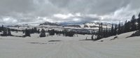
The start of Death Canyon Shelf.
And here i am at camp. It rained and ended up pretty wet here, and was not a pleasant night. I had to set up a wet tent with clod hands. I also managed to have a bad dream about a bear attacking me in my tent. It was cold, but not terrible. Mostly just every thing being wet that sucked. Rain on snow. The tiny puddles in side the tent. The leaky rain gear.

Next day i got to hike the rest of the way along Death Canyon Shelf. It was really enjoyable, but also a lot of work.

Three miles.

Looking down Death Canyon from the shelf. This day was nice. No rain of consequence. The canyon looked much more inviting the the path ahead though. To the left.

This is approaching Mount Meeks Pass, looking back, all the way along Death Canyon Shelf.
.JPG")
Mount Meeks Pass. Death Canyon Shelf is actually to the left of the wall in the picture here. The wall turns a corner, and just continues along in a different direction.

Looking across Alaska Basin from the pass. On the right here you can see the trail for just a moment.
This is at the Sheep Steps. I just walked down the slope on the snow.

Looking back across Alaska Basin from the other side. The pass from Death Canyon Shelf in the center. Some of the hike up from the Basin was exposed. I couldn't see any of the lakes though. This picture is from that exposed stretch.

Looking toward Hurricane Pass. Near Sunset Lake. Battleship Mountain on the left. Lots of snow, and with out a trail, i had to figure out my own way up the pass most of the way. This did not make good time.

These were the only people i saw that entire day. And this was as close as we ever came. Sunset Lake beyond them. On my way between Alaska Basin and Hurricane Pass.

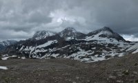
One of the peaks showing through the clouds.

On top of Hurricane Pass, looking back. There's a notch on the horizon left of center that is Mount Meeks Pass, where i came from Death Canyon Shelf. On the right you can see Battleship Mountain. This was the one place that i got off track in the snow. I headed toward the wrong col, closer to the Battleship. It was more obvious. The route actually wraps around to an other col. It only gave me trouble for a moment. The wrong canyon looked obviously wrong, it opened to the wrong side of the range. Also there was no way into it. So i corrected my mistake.

View of the Tetons from Hurricane Pass. Looking over South Fork Cascade Canyon. You can see Schoolroom Glacier all the way on the right, and even better, it's moraine. Finally i just had to make it down to a site where i could set up camp. It had been a long day. I only had about ten miles to do this day, but more than 90% of it was snow bound. No trails, just following the map across the terrain. It was still a little bit wet out, still not bad, but there was no where good to stop and rest. I ended up just pushing through every thing. Also i had skipped dinner the night before, tired of dealing with the wet and cold, and just curled up to sleep. I ate that dinner for breakfast in stead.

So i made my way down into South Fork Cascade Canyon, still mostly over snow. Eventually i found a spot to stop and eat just a little ways down into the canyon. But it didn't agree with me. I think i had over exerted my self and under eaten for too much of the day. I felt sick a few minutes later, and tried to wait it out, but eventually ended up vomiting. After that i felt much better. I made my way far enough down canyon to find a camp site that wasn't entirely covered in snow. Also, coming down the trail just below the picture above, the wind blew hard enough to actually tear my permit off of my pack. I watched it sail straight away in the wind until it passed a cliff with out ever touching the ground.
Teton was the marmottiest park i have ever been to. I passed these guys on the way down.


After the second night, in South Fork Cascade Canyon, the weather turned beautiful, and the rest of the trip was fantastic. After vomiting the day before, not being entirely sure how my body was doing, i decided against going over the Paintbrush Divide like i'd planned, when i came to the trail for North Fork Cascade Canyon. In stead i hiked down the combined Cascade Canyon to Jenny Lake, along the lake trail, and back up Paintbrush Canyon to camp. It was nearly 12 miles, in stead of the 7 it would have been going over the divide, but i think it was the right thing to do. i probably could have made it over, but if some thing hadn't gone well, chances were good i wouldn't see any one else out there. Also i probably would not have enjoyed it regardless. I'd walked over enough snow for this trip.
The junction of North and South Forks of Cascade Canyon. I'm looking down South, North comes in from the left, and Cascade Canyon continues up from center to the right. It was a pretty canyon, the whole way down. There were views of the peaks above.
.JPG")
Cascade Creek.

Cascade Creek, looking back up the canyon. I really enjoyed having sunnier days from here on. This was all easy walking with slow elevation change.

Jenny Lake. You can see the zoo on the right where people come and go on the boats. It was ridiculous how crowded much of the trail was near the lake, especially after the solitude of the day before. Must be hudreds of people between Inspiration Point and the boat docks. Near here i came across some one i recognized having passed on the way down, now coming from below me. I talked to him, and he told me that he had taken the horse trail down to the lake to avoid the crowds. I wished that i had known that before, but appreciated knowing it now. It makes such perfect sense.

I walked around Jenny Lake, and then up String Lake. I liked String Lake for it's unique shape. And for the happy people playing in it.

An other varmint.

Above String Lake the trail turns into Paintbrush Canyon. I went up canyon a couple miles. The view from Paintbrush is fantastict. This is looking back down the canyon from where i set up camp. It's the last site in the Lower Paintbrush zone, and is probably the best. No snow, which was nice. i was glad that i came here, in stead of bailing on the rest of the trip after getting ill the day before.

Just before sunrise the next morning. In this light you can see Leigh and Jackson Lakes.

And then the sun.


Marmots again.

Once the show was over i packed up and headed out. I'd already eaten while waiting. Nice easy hiking back down Paintbrush.
This squirrel yelled at me, i yelled back.

Walking down the trail from the mouth of Paintbrush Canyon above String Lake, i heard a noise above me on the trail
 and there was the bear
and then an other one.

They walked probably about 30 feet from me. Never even looked at me. So i didn't say any thing to bother them. They walked from above the trail down to where i had already come past, and then walked off.

You know that character Wilson, from the show Home Improvement, who's face you never see. These bears reminded me of him. not a single picture of their faces. A bush, every single time. Better than getting too good a view of their face though.
After passing the bears i walked bast past String Lake again. It was nice in the early morning. No other hikers. When i came to the junction at Jenny Lake again i walked around it on the other side this time, opposite the mountains. Mostly i saw trees, but there were a couple times that i got good views of the peaks across the lake. Here you can see across, Cascade Canyon center, which i hiked out of the morning before. It was about three miles just along the lake. After that i continued on the valley trail. A little way through open grass, but also some more hiking up through the forest. There was more elevation change on the valley trail than i would have expected. It was almost annoying. It was a good day though. I got the day's twelve miles all done before noon, and set up camp at Bradley Lake. With no thing else to do for the rest of the day, i enjoyed one of my favorite wilderness activities. I took a nap. I slept until around 5 pm, ate dinner, and lounged around some more. It was great. The scenery was beautiful, i was the only one at the camp, and it was off the trail, so no one else even came into sight.
 Bradley Lake the next morning, just before i left camp.
The next day, my last, i just had an other 12 miles to hike back to my car at the trail head. I managed to wake up early again. This is looking at the wide, marshy outlet of Bradley Lake as i walked past.
I think that this day was slightly flatter than the one before. Still some ups and downs though. Here's the view across Bradley Lake as i left it. Every thing was perfectly flat that morning, not a bit of movement on the water.
The valley trail. I wound through trees and flowers, past lakes back to my car.

Not far from Bradley Lake is Taggart Lake. An other great view across from it's far end.
The trail passes above Phelps Lake, which is actually more than twice as large as Bradley or Taggart. It lies just below the mouth of Death Canyon, which i had passed above the head of, on the Shelf, three days before. It was nice being able to see all the way out across Jackson Hole to the other side.
An other good day, i finished hiking before noon again. And my car was still there, and it started. I went back to the park wilderness office to return my bear canister. I think that if the weather had been as nice on the first two days as it was on the rest of the trip i would've had a much easier time, probably gone over Paintbrush Divide like i originally planned. The miles over snow would've been more doable if it hadn't been wet and raining on top of it.
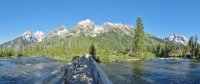
On the way out i could finally see the range in it's fulness. Glad i went. Goodbye.


Featured image for home page:

I got to the park early after sleeping in my car at a gas station parking lot just past Idaho Falls. Good times. It was pretty gray. Couldn't see the mountains driving in even. Still pretty though. I picked up my permit shortly after the backcountry office opened, and transferred my food into the bear canister that i checked out there. I drove the rest of the way out to Granite Canyon and the parking lot there at the trail head. This is very near the start of the trail.
The first day i had to hike up Granite Canyon, and then over to the Death Canyon Shelf camp zone, about 13 miles. May be 3300' elevation gain. It's nine miles up to Marion Lake at the top of Granite Canyon, and then four miles into the Death Canyon Shelf area. There were some snail shells in Granite Canyon. There was a live one too, but it wasn't as photogenic as this. It rained just a little on and off going up the canyon. Not too bad. It was plenty green in the canyon, and occasionally misty. I passed this guy horse eying me across the creek. Wet trail. I never found the elevation gain bad. It was gradual enough.
Looking down at Granite Creek, looks like some thing might've blocked the creek up making it flood. Rounding out the moose family.A little shy of 9000' snow cover became more consistent. Near the end of the canyon i opted against crossing the creek to the south, the trail was entirely snow bound on that side. It only curves back around eventually any way. In stead i walked up the exposed hill side between the trail and Marion Lake. Steep, but less snow, and shorter. Here's looking back down Granite Canyon from the top of that hill. The rain had let up some, but it would come back later.
A sign of things to come.
Here's Marion Lake, just above the end of the canyon.
From Marion Lake i continued gaining slight elevation. This is one of the last snow free stretches for several miles. Looking back at the walls above Marion Lake, which is on the left side.
I continued toward Fox Creek Pass, below Spearhead peak. The pass in the center, the peak right center. This stretch wasn't bad.
At Fox Creek pass. Death Canyon Shelf sits to the right of the wall in the picture. This is also about the time it started to rain enough to actually get me wet.
The start of Death Canyon Shelf.
And here i am at camp. It rained and ended up pretty wet here, and was not a pleasant night. I had to set up a wet tent with clod hands. I also managed to have a bad dream about a bear attacking me in my tent. It was cold, but not terrible. Mostly just every thing being wet that sucked. Rain on snow. The tiny puddles in side the tent. The leaky rain gear.
Next day i got to hike the rest of the way along Death Canyon Shelf. It was really enjoyable, but also a lot of work.
Three miles.
Looking down Death Canyon from the shelf. This day was nice. No rain of consequence. The canyon looked much more inviting the the path ahead though. To the left.
This is approaching Mount Meeks Pass, looking back, all the way along Death Canyon Shelf.
Mount Meeks Pass. Death Canyon Shelf is actually to the left of the wall in the picture here. The wall turns a corner, and just continues along in a different direction.
Looking across Alaska Basin from the pass. On the right here you can see the trail for just a moment.
This is at the Sheep Steps. I just walked down the slope on the snow.
Looking back across Alaska Basin from the other side. The pass from Death Canyon Shelf in the center. Some of the hike up from the Basin was exposed. I couldn't see any of the lakes though. This picture is from that exposed stretch.
Looking toward Hurricane Pass. Near Sunset Lake. Battleship Mountain on the left. Lots of snow, and with out a trail, i had to figure out my own way up the pass most of the way. This did not make good time.
These were the only people i saw that entire day. And this was as close as we ever came. Sunset Lake beyond them. On my way between Alaska Basin and Hurricane Pass.
One of the peaks showing through the clouds.
On top of Hurricane Pass, looking back. There's a notch on the horizon left of center that is Mount Meeks Pass, where i came from Death Canyon Shelf. On the right you can see Battleship Mountain. This was the one place that i got off track in the snow. I headed toward the wrong col, closer to the Battleship. It was more obvious. The route actually wraps around to an other col. It only gave me trouble for a moment. The wrong canyon looked obviously wrong, it opened to the wrong side of the range. Also there was no way into it. So i corrected my mistake.
View of the Tetons from Hurricane Pass. Looking over South Fork Cascade Canyon. You can see Schoolroom Glacier all the way on the right, and even better, it's moraine. Finally i just had to make it down to a site where i could set up camp. It had been a long day. I only had about ten miles to do this day, but more than 90% of it was snow bound. No trails, just following the map across the terrain. It was still a little bit wet out, still not bad, but there was no where good to stop and rest. I ended up just pushing through every thing. Also i had skipped dinner the night before, tired of dealing with the wet and cold, and just curled up to sleep. I ate that dinner for breakfast in stead.
So i made my way down into South Fork Cascade Canyon, still mostly over snow. Eventually i found a spot to stop and eat just a little ways down into the canyon. But it didn't agree with me. I think i had over exerted my self and under eaten for too much of the day. I felt sick a few minutes later, and tried to wait it out, but eventually ended up vomiting. After that i felt much better. I made my way far enough down canyon to find a camp site that wasn't entirely covered in snow. Also, coming down the trail just below the picture above, the wind blew hard enough to actually tear my permit off of my pack. I watched it sail straight away in the wind until it passed a cliff with out ever touching the ground.
Teton was the marmottiest park i have ever been to. I passed these guys on the way down.
After the second night, in South Fork Cascade Canyon, the weather turned beautiful, and the rest of the trip was fantastic. After vomiting the day before, not being entirely sure how my body was doing, i decided against going over the Paintbrush Divide like i'd planned, when i came to the trail for North Fork Cascade Canyon. In stead i hiked down the combined Cascade Canyon to Jenny Lake, along the lake trail, and back up Paintbrush Canyon to camp. It was nearly 12 miles, in stead of the 7 it would have been going over the divide, but i think it was the right thing to do. i probably could have made it over, but if some thing hadn't gone well, chances were good i wouldn't see any one else out there. Also i probably would not have enjoyed it regardless. I'd walked over enough snow for this trip.
The junction of North and South Forks of Cascade Canyon. I'm looking down South, North comes in from the left, and Cascade Canyon continues up from center to the right. It was a pretty canyon, the whole way down. There were views of the peaks above.
Cascade Creek.
Cascade Creek, looking back up the canyon. I really enjoyed having sunnier days from here on. This was all easy walking with slow elevation change.
Jenny Lake. You can see the zoo on the right where people come and go on the boats. It was ridiculous how crowded much of the trail was near the lake, especially after the solitude of the day before. Must be hudreds of people between Inspiration Point and the boat docks. Near here i came across some one i recognized having passed on the way down, now coming from below me. I talked to him, and he told me that he had taken the horse trail down to the lake to avoid the crowds. I wished that i had known that before, but appreciated knowing it now. It makes such perfect sense.
I walked around Jenny Lake, and then up String Lake. I liked String Lake for it's unique shape. And for the happy people playing in it.
An other varmint.
Above String Lake the trail turns into Paintbrush Canyon. I went up canyon a couple miles. The view from Paintbrush is fantastict. This is looking back down the canyon from where i set up camp. It's the last site in the Lower Paintbrush zone, and is probably the best. No snow, which was nice. i was glad that i came here, in stead of bailing on the rest of the trip after getting ill the day before.
Just before sunrise the next morning. In this light you can see Leigh and Jackson Lakes.
And then the sun.
Marmots again.
Once the show was over i packed up and headed out. I'd already eaten while waiting. Nice easy hiking back down Paintbrush.
This squirrel yelled at me, i yelled back.
Walking down the trail from the mouth of Paintbrush Canyon above String Lake, i heard a noise above me on the trail
and there was the bearand then an other one.
They walked probably about 30 feet from me. Never even looked at me. So i didn't say any thing to bother them. They walked from above the trail down to where i had already come past, and then walked off.
You know that character Wilson, from the show Home Improvement, who's face you never see. These bears reminded me of him. not a single picture of their faces. A bush, every single time. Better than getting too good a view of their face though.
After passing the bears i walked bast past String Lake again. It was nice in the early morning. No other hikers. When i came to the junction at Jenny Lake again i walked around it on the other side this time, opposite the mountains. Mostly i saw trees, but there were a couple times that i got good views of the peaks across the lake. Here you can see across, Cascade Canyon center, which i hiked out of the morning before.
It was about three miles just along the lake. After that i continued on the valley trail. A little way through open grass, but also some more hiking up through the forest. There was more elevation change on the valley trail than i would have expected. It was almost annoying. It was a good day though. I got the day's twelve miles all done before noon, and set up camp at Bradley Lake. With no thing else to do for the rest of the day, i enjoyed one of my favorite wilderness activities. I took a nap. I slept until around 5 pm, ate dinner, and lounged around some more. It was great. The scenery was beautiful, i was the only one at the camp, and it was off the trail, so no one else even came into sight. Bradley Lake the next morning, just before i left camp.The next day, my last, i just had an other 12 miles to hike back to my car at the trail head. I managed to wake up early again. This is looking at the wide, marshy outlet of Bradley Lake as i walked past.
I think that this day was slightly flatter than the one before. Still some ups and downs though. Here's the view across Bradley Lake as i left it. Every thing was perfectly flat that morning, not a bit of movement on the water.
The valley trail. I wound through trees and flowers, past lakes back to my car.
Not far from Bradley Lake is Taggart Lake. An other great view across from it's far end.
The trail passes above Phelps Lake, which is actually more than twice as large as Bradley or Taggart. It lies just below the mouth of Death Canyon, which i had passed above the head of, on the Shelf, three days before. It was nice being able to see all the way out across Jackson Hole to the other side.
An other good day, i finished hiking before noon again. And my car was still there, and it started. I went back to the park wilderness office to return my bear canister. I think that if the weather had been as nice on the first two days as it was on the rest of the trip i would've had a much easier time, probably gone over Paintbrush Divide like i originally planned. The miles over snow would've been more doable if it hadn't been wet and raining on top of it.
On the way out i could finally see the range in it's fulness.
Glad i went. Goodbye. Featured image for home page: