Bob
Trailmaster
- Joined
- Mar 3, 2013
- Messages
- 4,761
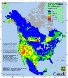
So people are aware... fire near Pinedale Wy. May create some smoke.....
Tannerite Fire Draws Multi-Agency Response Pinedale, Wyo, August 18, 2019 - The Tannerite Fire, burning near Boulder Lake south of Pinedale, started Saturday, Aug. 17 at 12:52 pm on land managed by the Bureau of Land Management (BLM). The fire is human caused and is under investigation at this time. The primary objective for this incident is to ensure the safety of firefighters and the public. Protection of structures and private property is also a key objective. Homes and other structures are threatened but as of this morning, no primary residences have been burned. A Western Wyoming Type 3 Incident Management Team is shadowing current leadership and will be assuming command of the fire by tomorrow morning. The fire has burned on multiple jurisdictions and is under unified command with the BLM as lead agency. Sublette County stood up an Emergency Operations Center (EOC) at the Sublette County Emergency Management office, 307-367-3378. Current fire size is estimated to be 1,340 acres burning in sage, grass and timber. Evacuations are in effect for the Boulder Lake Estates, Boulder Lake Campground, Burnt and Meadow Lake and associated trailheads. Red Cross has set up a shelter for people with primary residences in the evacuation area, although there were no persons requiring shelter last night. No additional evacuations are foreseen. Road closures are in place on the Boulder Lake and the Burnt Lake roads. Resources fighting the fire include: 7 engines (both Type 4 and Type 6), 1 water tender, 2 Type 3 helicopters, 2 Type 1 helicopters, 1 Type 2 IA handcrew, 8 smokejumpers, 5 person fire module, 5 helitack crewmembers, air attack and fixed wing retardant tankers as needed. Crews will be facing red flag conditions again today through Monday evening. High temperatures, low humidity, and strong winds will make control efforts challenging.
Tannerite Fire Draws Multi-Agency Response Pinedale, Wyo, August 18, 2019 - The Tannerite Fire, burning near Boulder Lake south of Pinedale, started Saturday, Aug. 17 at 12:52 pm on land managed by the Bureau of Land Management (BLM). The fire is human caused and is under investigation at this time. The primary objective for this incident is to ensure the safety of firefighters and the public. Protection of structures and private property is also a key objective. Homes and other structures are threatened but as of this morning, no primary residences have been burned. A Western Wyoming Type 3 Incident Management Team is shadowing current leadership and will be assuming command of the fire by tomorrow morning. The fire has burned on multiple jurisdictions and is under unified command with the BLM as lead agency. Sublette County stood up an Emergency Operations Center (EOC) at the Sublette County Emergency Management office, 307-367-3378. Current fire size is estimated to be 1,340 acres burning in sage, grass and timber. Evacuations are in effect for the Boulder Lake Estates, Boulder Lake Campground, Burnt and Meadow Lake and associated trailheads. Red Cross has set up a shelter for people with primary residences in the evacuation area, although there were no persons requiring shelter last night. No additional evacuations are foreseen. Road closures are in place on the Boulder Lake and the Burnt Lake roads. Resources fighting the fire include: 7 engines (both Type 4 and Type 6), 1 water tender, 2 Type 3 helicopters, 2 Type 1 helicopters, 1 Type 2 IA handcrew, 8 smokejumpers, 5 person fire module, 5 helitack crewmembers, air attack and fixed wing retardant tankers as needed. Crews will be facing red flag conditions again today through Monday evening. High temperatures, low humidity, and strong winds will make control efforts challenging.


