Table Mountain/Tetons Late Summer

jkgear

Member
Joined
Jan 27, 2016
Messages
7
Howdy! Long time reader, first time posting. I recently did a mini 2-night hike on the southern portion of the crest trail via the Tram; 1 night at Marion Lake, and out through Death Canyon and spending the 2nd night at Phelps Lake. However, after previous trips to the Driggs/GTNP area, during my next visit I want to hike Table Mountain. I have read some of the threads about Table Mountain, and I am curious if there is a route connecting Table Mountain to the South Fork Cascade trail. I am also wondering if this would be permitted by the NPS. My naive plan is: Day 1 pick up permits in at the visitor center and drive to Driggs, stay there for the night. Day 2: Enter through the Face Trail at Teton Canyon, up Table Mountain, camp at South Fork Cascade. Day 3: Camp at Upper Paintbrush/Holly Lake. Day 4: Hike out at String Lake. I'm open to any and all suggestions or advice!
 
I've yet to get up there myself, so I won't be much help but I've been hoping to make a weekend trip up that way myself with plans to do a partial loop starting up Darby Canyon, cross over into Fox Canyon and stay a night, then enter GTNP and the Teton Crest Trail at Fox Pass, Hike along Death Shelf down into Alaska Basin to stay another night, then aim for Table Mountain from Hurricane Pass before rounding out the trip down at the Teton Canyon trailhead. In looking at the topo and terrain on maps and satellite, it doesn't look like there should be any real technical scrambling in traversing the ridge between Table Mountain and Hurricane Pass. Hurricane Pass will obviously connect you with the trail you're wanting to hook up to take you down into South Fork Cascade. Of course, I could be seriously deceived, so I too would be interested to see if anyone else is familiar with that strip between Table and Hurricane.
 
I hiked about half of the Darby trail one afternoon but it was just a quick out and back. I'd love to do the whole thing. I was looking at the topo map, and I think there might be a route from the north slope of Table mountain that could intersect the South Fork trail. Again, I have no clue, just going off of the maps I can find.
 
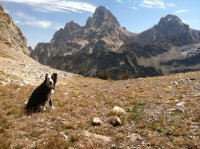
I've done the Table Mountain to Hurricane as part of a run. Up Face trail to Table Mt with my wife and friend then my dog and I scrambled down the south face of table and along the west side of the ridge to Hurricane Pass, then out Alaska Basin to the TH. The cross country between Table and Hurricane is not technical. It will be a steep scramble with some talus up to Table but no danger of falling. I dropped off Table just below the summit knob. The photo below is at the pass below Table Mt after scrambling down and before traversing over to Hurricane Pass.IMG_2369.JPG
 
Your route is totally doable. Another way to do it (and still on my short list) is (once your at Table Mountain) to stay outside the park boundaries until you get to Paintbrush Divide. A friend of mine (@Joey ) explored this section last September and could give you more specifics. But as an overview, once you get from Teton Canyon to Table Mountain you can stay up high and camp at the Wigwams. Then heading north still up high above Mica Lake and camping above Lake Solitude. Then around toward Paintbrush where you can get back on trail and head down toward Holly Lake and either the upper or lower camp zone in Paintbrush Canyon.
 
I've seen various trip reports on the web of folks doing that route, all describe it as an easy scramble/walk-up (or rather walk-down, as most seem to go the Table Mtn -> Hurricane Pass direction). Somewhere I even saw someone's .gpx route mapped on a topo. I was researching that segment too, as we have considered a route from the Owl/Moose/Berry creek area at the north end of TNP, up over Moose Divide to the north part of the TCT (the part few people hike anymore), south to Granite/Green/Leigh lakes, to Table Mtn then down to Hurricane, and down Paintbrush or Cascade.

When we did the Teton Crest Trail a couple of years ago, I remember when we got to Hurricane, I spent some time looking up at TM, trying to gauge where the best route would be. Anyway, I'll go through my notes and see if I can find the link to that route, and post it here if I find it.

Hey @Chuck the Mauler , I remember you from the BackPacker forums a few years ago. You provided me with lots of useful info/data on that board. I never went back after they screwed up the interface. But nice to see you here, so I could thank you for all your help.
 
Here is a video of a trip we did in that part of the park 2 years ago. After spending too much time in that part of the park we were pressed for time and dropped over the backside of South Fork Moran Canyon and hit the trail . Had a chance to see the Green Lake area and could see exploring that area again. We were trying to beat an on coming storm and had to hustle down into Leigh Canyon. I believe @Bob posted a gpx file some time ago with a similar route staying outside (west of) the park and missing Moose Basin, Glacier Lakes, Ortenburger Lake and some of the interior northern canyons then dropping down behind Lake Solitude hiking both the North and South forks before getting back outside the park to avoid overnight camping permits. That would be an easier alternative.

We fell short and ended up exiting via Leigh Canyon. But was one of the most incredible trips I've ever done! The best way to exit (IMO) from Hurricane is out Avalanche Canyon. Seldom walked and Snowdrift and Tamiah Lakes are awesome!! It's been a few years since I've been down that canyon.

In 2015 we did a similar trip but got snowed in up at Glacier Lake and ended up exiting to the Idaho side via Bitch Creek. We then paid a taxi $280 to get back to String Lake. I did that trip with @Vegan.Hiker , @Ben , @Joey and Vegans friend Craig.

@Langdon Greene , they messed up the old BPer site pretty good. The mod there "Steve" started a new site http://bpbasecamp.freeforums.net/ where you can find all the old usual suspects. Not nearly as vibrant as it once was. Side note, glad I could help. I love that place.
 
Last edited:
image.jpg
This is while moving up Alaska Basin and looking at Table Rock/Mountain and down into Cascade Canyon. You can see the unmapped trail going toward Table Rock (local name). If you turn right you are in Cascade Canyon.

If I remember right one path goes up the ledge and rocks. There is another that goes to the left then loops back up the mountain. Be advised they are not well marked or maintained to my knowledge. You may need to "John Wayne" it but it can be done.

I hiked TR for the first time about 30 years ago. Great hike.
 
Last edited:
Howdy! Long time reader, first time posting. I recently did a mini 2-night hike on the southern portion of the crest trail via the Tram; 1 night at Marion Lake, and out through Death Canyon and spending the 2nd night at Phelps Lake. However, after previous trips to the Driggs/GTNP area, during my next visit I want to hike Table Mountain. I have read some of the threads about Table Mountain, and I am curious if there is a route connecting Table Mountain to the South Fork Cascade trail. I am also wondering if this would be permitted by the NPS. My naive plan is: Day 1 pick up permits in at the visitor center and drive to Driggs, stay there for the night. Day 2: Enter through the Face Trail at Teton Canyon, up Table Mountain, camp at South Fork Cascade. Day 3: Camp at Upper Paintbrush/Holly Lake. Day 4: Hike out at String Lake. I'm open to any and all suggestions or advice!
Was there a trail to follow from Table MT to South Fork Cascade?
 
Can come down the Cirque headwall pretty easy above lk Solitude. Never been from table to there. I do know of someone that followed the divide between there .. but know nothing else
 
Was there a trail to follow from Table Mt to South Fork Cascade?

I hiked around Table Mtn (skirted last few hundred feet) last fall from N to S. There is no trail from Table Mtn to the pass south of Table Mtn, and from there, no trail to S Fk Cascade Trail that I saw, but once off Table Mtn, the going is straight forward from the pass to the trail. It has some steep sections and some bushwhacking but all-in-all, it was pretty easy.
 
Similar threads
Thread starter Title Forum Replies Date
tomcat32 Table Mountain: A Grand View of the Tetons Hiking & Camping 3
Kullaberg63 An ascent of Table Mountain, Tetons Hiking & Camping 7
SteveR Table to Whistler Ridgewalk Hiking & Camping 6
woodmaker_58 Table Mt to Hurricane Pass/ Teton Crest Trail Trip Planning 5
andyjaggy Portable Picnic Table Gear 5
Mikjik86 Hiking Colorado - 13er Bald Mountain 13,703' Hiking & Camping 2
B Hello mountain people! Noobs: Introduce yourself! 0
BeardoMcGrath Fiftymile Mountain rim and ruins tour: 13 May 2023 Hiking & Camping 12
Ugly Oh Mother! A Mountain Loop Backpacking 12
TheMountainRabbit Southern Absaroka & Thorofare Mountain (Teton/Washakie Wilderness) - July 2023 Backpacking 23
O Eagle Cap from China Cap to Meadow Mountain Backpacking 3
kwc Hadley Mountain hike Hiking & Camping 1
scatman Black Mountain Ridge - May 13, 2023 Hiking & Camping 49
kwc Spruce Mountain Fire Tower, Southern Adirondacks Hiking & Camping 0
regehr conditions at the Mexican Mountain road? Trip Planning 8
scatman Little Mountain - January 21, 2023 Hiking & Camping 28
TheMountainRabbit Black Lake (Rocky Mountain NP) - January 2023 Hiking & Camping 3
TheMountainRabbit Sky Pond (Rocky Mountain NP) - January 2023 Hiking & Camping 8
kwc Snowy Mountain, central Adirondacks Hiking & Camping 0
XID_AZ Kanab Creek Wilderness - Sowats Canyon - Mountain Sheep Spring Trip Planning 6
scatman Bald Mountain - August 20, 2022 Hiking & Camping 7
regehr mountain-forecast.com Trip Planning 22
Absarokanaut Welcome First Peoples Mountain General Discussion 0
scatman Mendon Peak - Wellsville Mountain Wilderness - June 4, 2022 Hiking & Camping 13
andyjaggy Wind River Range Roberts Mountain Trip Planning 4
LarryBoy SLC: Terrace Hills Drive to Big Mountain Peak Trip Planning 16
pstm13 Rocky Mountain National Park Mid June with Kids Trip Planning 7
pstm13 Rocky Mountain National Park Mid June with Kids Trip Planning 0
scatman Little Mountain - January 22, 2022 Hiking & Camping 1
scatman Jack's Mountain - December 24, 2021 Hiking & Camping 11
norwegianxplorer Highest Mountain in Norway, Galdhøpiggen, the start of a 9 day backpacking trip in Jotunheimen national park Backpacking 0
scatman Foothill Follies Part 2 - Black Mountain Ridge and City Creek Canyon Loop - November 11, 2021 Hiking & Camping 6
kwc Hadley Mountain Fire Tower hike, Southern Adirondacks Hiking & Camping 1
kwc Moxham Mountain, Adirondacks Hiking & Camping 3
J Death Valley National Park and Area Mountain Rambles Dec. 16-17, 2020 Hiking & Camping 0
scatman Black Mountain - May 22, 2021 Hiking & Camping 9
kwc Blue Mountain hike, Central Adirondacks Hiking & Camping 0
kwc Goodnow Mountain fire tower hike Hiking & Camping 2
LarryBoy Five Days on Boulder Mountain Backpacking 5
norwegianxplorer Greater Yellowstone part 2, from the Headwaters of Yellowstone River, through the Thorofare, Overlook Mountain, Rampart Creek Backpacking 9
kwc Chimney Mountain, South Central Adirondacks Hiking & Camping 3
regehr Sid's Mountain Loop Backpacking 5
fossana Bat Mountain traverse (Funeral Mountains) Hiking & Camping 5
Yvonne Sepulcher Mountain Hike, Yellowstone NP, September 2018 Hiking & Camping 2
UtahBrian Sids Mountain Wilderness November 2019 Backpacking 5
K Cycling The Divide Mountain Route Trip Planning 16
NorthwestWanderer Olympic National Park - Elk Mountain Hiking & Camping 7
Titans Prescribed burn South Monroe Mountain- photos from Capitol Reef area Photography 0
Born to Hike Mountain Solitude: Reconnaissance Lake, High Uintas, early Sept 2019 Backpacking 9
DownPour Mountain House meals and Ziplock bags General Discussion 7

Similar threads

Back
Top