Cody
Member
- Joined
- Mar 4, 2012
- Messages
- 100
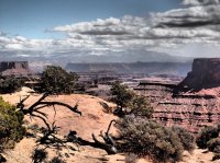
I outran a mild spring blizzard on the Wasatch Front Thursday morning and headed down to Island in the Sky for my first trip of spring. I picked up a permit for a night in the Syncline Valley and an extra night in the Taylor Zone, just in case I wanted to linger and explore another day. I had in mind a 20-ish mile loop down the Syncline to the north of the Upheaval Dome, overnight at the the bottom of Syncline and then down Upheaval Canyon to the Green River, along the White Rim Road, up Taylor and eventually climbing out Trail Canyon via the Alcove Spring Trail. The weather forecast didn't look great and there was a stiff wind all morning driving south, but when I got out of the truck at the Island VC, it was about as nice a spring day as I could imagine.I pulled my permit, then stopped for a few roadside photos on the way to the trail.


I parked at the Alcove Spring TH where I would eventually exit and walked down the road a little ways to Upheaval Dome. I climbed up to the first overlook for a peek at the dome and to get a route overview.

The Upheaval Dome

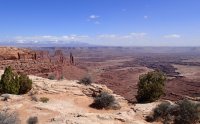
The trail is physical, but not exceptionally tough, and is well cairned. Given that it is next to one of the major touristy turn-outs, I suppose it needs a scare sign. The only tricky section is the bypass of a dryfall with some very mild exposure in Syncline Canyon.


Here in the lower section of Syncline, the trail climbs up quite a bit to bypass a dryfall. Gives you nice views of the route ahead into Upheaval Canyon. There was nice clear flowing water in several sections of Syncline.

I made it to camp with a couple hours of daylight and explored the Upheaval Crater from the bottom up for a mile or so then set up camp. There was possible rain in the forecast, but it never showed up.

[bimg=Cooking with Esbit]https://lh3.googleusercontent.com/-gfgocVca550/UU38JifK55I/AAAAAAAAYBg/MgHX8zIRJeQ/s821/P3210103.JPG[/bimg]
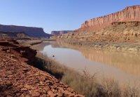
I woke up and got moving down Upheaval Canyon to warm up and planned on doing breakfast on the Green River. Upheaval Canyon opens up after a few miles and eventually intersects the White Rim Road right on the Green.


White Rim Road

My sunny breakfast spot.


From the Green River I headed up Taylor passing Moses and Zeus

Moses and Zeus

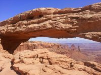
I didn't shoot many pictures in Trail Canyon along the Alcove Springs Trail. By that time I had decided to hike out that afternoon and a burger from Ray's Tavern was calling for me. It was a nice section though and had flowing springs in a couple of side canyons.

The climb back up to the rim looks a little perplexing from the bottom, but it works its way nicely up along the cliff via what appears in a few places to be an old cattle road although the grade has sluffed off along most of it. The park road to Upheaval Dome sits just above the rim where my truck was waiting. Short and sweet, just what I needed. I came home to more winter on the Wasatch Front, with another 6" snow this morning.
Featured image for home page:

I parked at the Alcove Spring TH where I would eventually exit and walked down the road a little ways to Upheaval Dome. I climbed up to the first overlook for a peek at the dome and to get a route overview.
The Upheaval Dome
The trail is physical, but not exceptionally tough, and is well cairned. Given that it is next to one of the major touristy turn-outs, I suppose it needs a scare sign. The only tricky section is the bypass of a dryfall with some very mild exposure in Syncline Canyon.
Here in the lower section of Syncline, the trail climbs up quite a bit to bypass a dryfall. Gives you nice views of the route ahead into Upheaval Canyon. There was nice clear flowing water in several sections of Syncline.
I made it to camp with a couple hours of daylight and explored the Upheaval Crater from the bottom up for a mile or so then set up camp. There was possible rain in the forecast, but it never showed up.
[bimg=Cooking with Esbit]https://lh3.googleusercontent.com/-gfgocVca550/UU38JifK55I/AAAAAAAAYBg/MgHX8zIRJeQ/s821/P3210103.JPG[/bimg]
I woke up and got moving down Upheaval Canyon to warm up and planned on doing breakfast on the Green River. Upheaval Canyon opens up after a few miles and eventually intersects the White Rim Road right on the Green.
White Rim Road
My sunny breakfast spot.
From the Green River I headed up Taylor passing Moses and Zeus
Moses and Zeus
I didn't shoot many pictures in Trail Canyon along the Alcove Springs Trail. By that time I had decided to hike out that afternoon and a burger from Ray's Tavern was calling for me. It was a nice section though and had flowing springs in a couple of side canyons.
The climb back up to the rim looks a little perplexing from the bottom, but it works its way nicely up along the cliff via what appears in a few places to be an old cattle road although the grade has sluffed off along most of it. The park road to Upheaval Dome sits just above the rim where my truck was waiting. Short and sweet, just what I needed. I came home to more winter on the Wasatch Front, with another 6" snow this morning.
Featured image for home page:
")
