balzaccom
Member
- Joined
- Sep 30, 2014
- Messages
- 838
Labor Day weekend is one if the busiest times of the year in the back country. The combination of a long weekend, minimal mosquitoes, and a last gasp effort to get out in the trail means that many wilderness areas can be positively crowded, tent to tent at some lakes.
Which is what we were hoping to avoid by heading into the Summit City Canyon. We'd read the reports. There are no gorgeous lake destinations. It's hard work to get there, and the trail can be minimal at times. And it's not on the way to anywhere else, unless you're trying to hike the Tahoe to Yosemite Trail. We thought we might not run into many crowds.
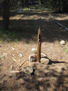
We'd been warned about this trail: difficult, hard to follow, steep, rough, and unmaintained. That's a junction marker at left...
Labor Day weekend was the perfect time to find out if all that was true. Besides, temperatures were supposed to go well over 100 in Northern California over the weekend. It was time to get up into the mountains!
It started well when I contacted the permit officer at the ranger station. She was so prepared to deal with one more permit for an easy to hike to lake just off the highway, that when she heard where we were going, she wondered if we even needed a permit. We did. And ours was the only permit for Summit City that she wrote for the whole weekend. in fact, she said it was the first one she could remember writing.
By arriving Thursday night at Upper Blue Lake campground, we had a wide choice of campsites. Of course they were all booked for the weekend, but getting there a day early meant we could stay there for one night and start hiking Friday morning. Perfect.
We were the only car in the trailhead parking lot when we started at 8:15, and twenty minutes later we were at 8600 feet at the top of the pass. It was all very much downhill from there.
Way downhill.
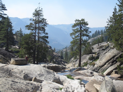
The trail crosses Summit City Creek and then starts to follow the old Pioneer mining road down into Summit City, often straight down the canyon. We were a bit concerned about the smoke from fires that had closed Monitor Pass, and kept looking up to see how bad the air was. It wasn't great.
But as we headed down the canyon past the junction to Fourth of July Lake, we started to really enjoy the hike.
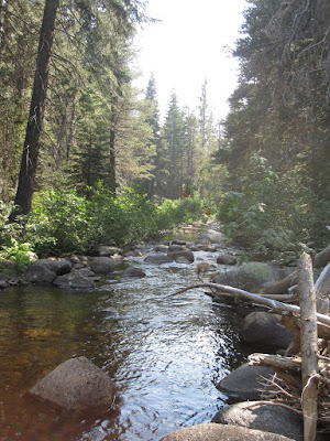
There was nobody in the trail. Nobody. It followed the creek, sometimes near, sometimes farther away, always within earshot. A glimpse of white water through the trees, or burbling current underneath a cloud of alders kept us entertained. On a hot day, the canyon was pleasantly cool. And we were hiking downhill.
I had promised M an easy day, so we stopped near Horse Creek and took a look around. We ate lunch, checked out the neighborhood, and found a spot nearby we liked as a campsite. After setting up camp, we took a nap, fished, sat around, and generally dawdled the afternoon away. Lovely.
The trail to this point had been perfectly maintained, except for the last junction post, which had been torn to pieces by bears. Weird.
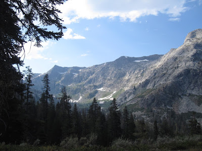
Some big puffs of smoke coming over the ridge from Round Top that afternoon got our attention, but they soon cleared up in the face of a few CDF planes.
We tried some new Singapore style ramen noodles I picked up at an Asian market for dinner...and fell into bed early feeling relaxed, secluded, and quite happy.
The next day the smoke had cleared a bit, and we decided to day hike down the canyon. We had no real destination, but we took a lunch, a fly rod, and played it by ear.
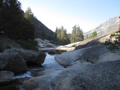
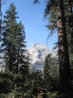
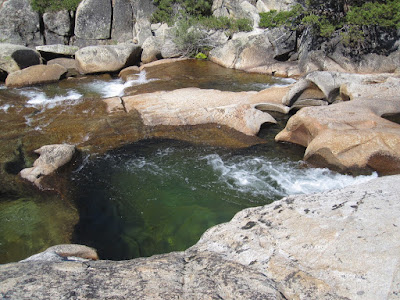
What a marvelous hike. The terrain alternated between cool green forests and sunny bare granite slabs that sent the creek into magical cascades and deep aquamarine pools. Each section seemed better than the last. We waded through a sea of ferns, and dipped our toes into pools twenty feet deep.
At the first ford, we debated continuing. If the smoke got worse, it would be better to head back. And M was a little hesitant about the ford. Ten minutes later, she put on her water shoes and away we went, meandering down through granite domes, navigating manzanita, and overlooking spectacular granite pools.
We did lose the trail very briefly a couple of times, once in the sea of ferns, and again just above the first ford, but each time a quick check of the topo map showed us where the trail needed to go...and we found it there.
By late morning we realized that we had covered a lot of ground, dropped quite a bit in elevation, and we would have to do all of that in reverse to get back to camp. Which we did, happily, stopping for lunch by one especially nice pool. I fished, M napped, and then we went back to camp and napped again. Despite the relatively easy hiking and crowded weekend, we hadn't seen anyone for two days.
By the evening the smoke had pretty much cleared up. We had a few clouds form, but that just gave us a little extra shade. The moonlight that night from a nearly full moon lit up our campsite for hours.
The next day was a cakewalk back to the car, which was now one of seven at the trailhead. We'd only seen one other couple on the way out, and they had hiked down from Fourth of July Lake. Three days backpacking over Labor Day weekend, and we had the place to ourselves. Amazing.
On the drive home we noted that the cars at the Tahoe Rim trailhead on Meyers Grade filled the parking and lined both sides of the highway, and the backup in Meyers went almost to the top of Echo Summit. Which made our adventure even more delicious.
A couple of notes about this trip. The fishing, despite the stunning beauty, was crappy. Not many fish, and they were small and skinny. It took me most of two hours to catch five fish over 7 inches long, and the biggest was a 9-inch stringbean that looked like it was starving. With all the bare granite, there may not be that much for trout to eat.
And this trail is not for everyone. If you are not comfortable following rock cairns for long distances, or don't like an occasional scramble up or down the granite, this is not for you. if you feel more comfortable seeing a few people every mile, that wont happen here. And we did not follow this trail all the way to the Mokelumne River. The last mile or two down into that canyon are reportedly more difficult than anything we hiked. Don't say we didn't warn you.
Still. Three days of backpacking over Labor Day weekend and complete solitude. Mmmmmmm.
The link to the photo log of the whole trip is here: https://photos.app.goo.gl/fdYMzjiebzPUDdvv2
Which is what we were hoping to avoid by heading into the Summit City Canyon. We'd read the reports. There are no gorgeous lake destinations. It's hard work to get there, and the trail can be minimal at times. And it's not on the way to anywhere else, unless you're trying to hike the Tahoe to Yosemite Trail. We thought we might not run into many crowds.
We'd been warned about this trail: difficult, hard to follow, steep, rough, and unmaintained. That's a junction marker at left...
Labor Day weekend was the perfect time to find out if all that was true. Besides, temperatures were supposed to go well over 100 in Northern California over the weekend. It was time to get up into the mountains!
It started well when I contacted the permit officer at the ranger station. She was so prepared to deal with one more permit for an easy to hike to lake just off the highway, that when she heard where we were going, she wondered if we even needed a permit. We did. And ours was the only permit for Summit City that she wrote for the whole weekend. in fact, she said it was the first one she could remember writing.
By arriving Thursday night at Upper Blue Lake campground, we had a wide choice of campsites. Of course they were all booked for the weekend, but getting there a day early meant we could stay there for one night and start hiking Friday morning. Perfect.
We were the only car in the trailhead parking lot when we started at 8:15, and twenty minutes later we were at 8600 feet at the top of the pass. It was all very much downhill from there.
Way downhill.
The trail crosses Summit City Creek and then starts to follow the old Pioneer mining road down into Summit City, often straight down the canyon. We were a bit concerned about the smoke from fires that had closed Monitor Pass, and kept looking up to see how bad the air was. It wasn't great.
But as we headed down the canyon past the junction to Fourth of July Lake, we started to really enjoy the hike.
There was nobody in the trail. Nobody. It followed the creek, sometimes near, sometimes farther away, always within earshot. A glimpse of white water through the trees, or burbling current underneath a cloud of alders kept us entertained. On a hot day, the canyon was pleasantly cool. And we were hiking downhill.
I had promised M an easy day, so we stopped near Horse Creek and took a look around. We ate lunch, checked out the neighborhood, and found a spot nearby we liked as a campsite. After setting up camp, we took a nap, fished, sat around, and generally dawdled the afternoon away. Lovely.
The trail to this point had been perfectly maintained, except for the last junction post, which had been torn to pieces by bears. Weird.
Some big puffs of smoke coming over the ridge from Round Top that afternoon got our attention, but they soon cleared up in the face of a few CDF planes.
We tried some new Singapore style ramen noodles I picked up at an Asian market for dinner...and fell into bed early feeling relaxed, secluded, and quite happy.
The next day the smoke had cleared a bit, and we decided to day hike down the canyon. We had no real destination, but we took a lunch, a fly rod, and played it by ear.
What a marvelous hike. The terrain alternated between cool green forests and sunny bare granite slabs that sent the creek into magical cascades and deep aquamarine pools. Each section seemed better than the last. We waded through a sea of ferns, and dipped our toes into pools twenty feet deep.
At the first ford, we debated continuing. If the smoke got worse, it would be better to head back. And M was a little hesitant about the ford. Ten minutes later, she put on her water shoes and away we went, meandering down through granite domes, navigating manzanita, and overlooking spectacular granite pools.
We did lose the trail very briefly a couple of times, once in the sea of ferns, and again just above the first ford, but each time a quick check of the topo map showed us where the trail needed to go...and we found it there.
By late morning we realized that we had covered a lot of ground, dropped quite a bit in elevation, and we would have to do all of that in reverse to get back to camp. Which we did, happily, stopping for lunch by one especially nice pool. I fished, M napped, and then we went back to camp and napped again. Despite the relatively easy hiking and crowded weekend, we hadn't seen anyone for two days.
By the evening the smoke had pretty much cleared up. We had a few clouds form, but that just gave us a little extra shade. The moonlight that night from a nearly full moon lit up our campsite for hours.
The next day was a cakewalk back to the car, which was now one of seven at the trailhead. We'd only seen one other couple on the way out, and they had hiked down from Fourth of July Lake. Three days backpacking over Labor Day weekend, and we had the place to ourselves. Amazing.
On the drive home we noted that the cars at the Tahoe Rim trailhead on Meyers Grade filled the parking and lined both sides of the highway, and the backup in Meyers went almost to the top of Echo Summit. Which made our adventure even more delicious.
A couple of notes about this trip. The fishing, despite the stunning beauty, was crappy. Not many fish, and they were small and skinny. It took me most of two hours to catch five fish over 7 inches long, and the biggest was a 9-inch stringbean that looked like it was starving. With all the bare granite, there may not be that much for trout to eat.
And this trail is not for everyone. If you are not comfortable following rock cairns for long distances, or don't like an occasional scramble up or down the granite, this is not for you. if you feel more comfortable seeing a few people every mile, that wont happen here. And we did not follow this trail all the way to the Mokelumne River. The last mile or two down into that canyon are reportedly more difficult than anything we hiked. Don't say we didn't warn you.
Still. Three days of backpacking over Labor Day weekend and complete solitude. Mmmmmmm.
The link to the photo log of the whole trip is here: https://photos.app.goo.gl/fdYMzjiebzPUDdvv2