regehr
Member
- Joined
- Mar 28, 2012
- Messages
- 2,445
The "Strava global heatmap" shows basically all tracks where people using the Strava app have been. It's a really fun way to look around.
https://labs.strava.com/heatmap/
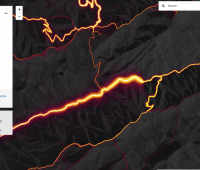
In this image the big bright line is the City Creek Road, the yellow below is the Little Black Mountain trail (with Smuggler's Gap connecting the two), the orange line heading north is the North Fork of City Creek to Rudy's Flat.

https://labs.strava.com/heatmap/
In this image the big bright line is the City Creek Road, the yellow below is the Little Black Mountain trail (with Smuggler's Gap connecting the two), the orange line heading north is the North Fork of City Creek to Rudy's Flat.

