Strava

regehr

Member
Joined
Mar 28, 2012
Messages
2,305
The "Strava global heatmap" shows basically all tracks where people using the Strava app have been. It's a really fun way to look around.

https://labs.strava.com/heatmap/

In this image the big bright line is the City Creek Road, the yellow below is the Little Black Mountain trail (with Smuggler's Gap connecting the two), the orange line heading north is the North Fork of City Creek to Rudy's Flat.
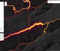
Screen Shot 2018-01-27 at 11.24.36 PM.png
 
That is awesome. I use Strava for running, but I had never seen this before.
 
this is super interesting. Apparently a few people broke the law by walking in the zion research areas. Lots of people going to bridge mountain arch and an incredibly small amount of people going to the willis creek boundary in zion, but they continued into the private land so who knows what that's about.
 
People are so paranoid about the government tracking them, and with this product anyone can. Jeez.

False Kiva's track is horrifying. Clearly less of a secret than some of ISky's official trails!
 
False Kiva's track is horrifying. Clearly less of a secret than some of ISky's official trails!
Interesting to see the mistaken routes people have taken trying to get there as well. I had never thought to use Strava hiking.
 
There are some interesting tracks on there. Bowknot Mesa, Solstice Snake, Tibbetts Inscription, Hatch Mesa, some weird stuff south of Blue Castle. Probably a good trip planning tool. ;)
 
as i look at these things i find it absolutely fascinating. Like im seeing the amount of people over how ever long this is from who went to CRAZY places. Apparently someone used this app while doing the thunderbird traverse in glacier and some CRAZY dude went from gifford wash in zion down to the east fork of the virgin river (illegal). whats more crazy is it's like a giant depository of lucid gps coordinates, like you can find routes using this thing... absolutely horrible but simultaneously SO COOL. Admittedly the buzz from this will likely die in a few weeks so we can have it all to ourselves lol
 
Someone just posted the link to this on a KY forum that I spend time on. You can see all of the "secret" places/routes are not so secret. Also giving me lots more to explore, I hope everyone quickly forgets about this and it never bubbles to the surface of the web again :)
 
Someone just posted the link to this on a KY forum that I spend time on. You can see all of the "secret" places/routes are not so secret. Also giving me lots more to explore, I hope everyone quickly forgets about this and it never bubbles to the surface of the web again :)
i know right?! if this doesn't get forgotten i'll be so sad :(
 
The crazy thing is probably like 1 in 25 hikers out there is running the Strava app. It's hilarious that someone would do that while hiking an illegal route. On the other hand, I can't see any tracks in Virginia Park.
 
Back
Top