stevecochranephotography
Member
- Joined
- Oct 26, 2017
- Messages
- 21
The Storm King Mountain Memorial Trail was built as a tribute to the 14 firefighters who lost their lives in the 1994 South Canyon Fire on Storm King Mountain.

The main trail will take you to an observation point from which you can see how the fire unfolded. Beyond the main trail is a path that will take you into the fire zone and to a memorial site. This path is very similar to what the firefighters deal with on a daily bases as they struggled up the ridge with 30 to 60 pound packs.

The trail begins with a 700 foot one mile climb that will get the legs and lungs pumping. There are signs reminding you that firefighters traverse these types of terrain with 30 to 60 pounds of gear in brutal heat.

About half way up this one mile section is a wishing stump. This is a nice place to catch your breath and make a wish.

As you continue to climb to the overlook you get extended views of the highway below.

As you gain the ridge line the first sign of the fire comes into view.

The main trail will take you to an observation point from which you can see most of the events of the fire. White crosses on the other side of the canyon mark where the firefighters fell. I’ve added a red arrow to the picture below to show the memorial site.
Some 50 firefighters were fighting the South Canyon Fire when suddenly the winds shifted and fire flared up. The fire crossed the bottom of the drainage and spread up the drainage towards the firefighters. The fire quickly overtook 12 of them. Two more firefighters were working on a helispot a short distance away. They also tried to outrun the fire and were overcome. The remaining firefighters survived by escaping off the back side of the mountain as others deployed their fire shelters as the fire passed by.

The trail drops into a valley below the observation point and then begins to climb to the memorial site. The trail was intentionally left rugged and steep to demonstrate the conditions in which the firefighters had to work.

As you walk to the memorial site you begin to walk through the thick and highly flammable oak brush. I begin to imagine being in this thick overgrowth and seeing a fire racing towards you with no place to run but up the steep mountain.

At the top of the ridge where several firefighters did escape off the back side of the mountain lays three burnt trees.

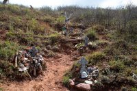
These trees are filled with mementos left by others to honor the fallen including caps, t-shirts, belt buckles, firefighting gear, and gloves.


From here you can go left for a third of a mile to a small plaque memorializing where the two helitack firefighters died. You can also drop off the ridge to the west to a steep trail leading down to the other twelve crosses. This trail is the fire line the firefighters were building during the fire. Like the trees on the ridge line, each cross is filled with mementos left by other firefighters who have hiked the trail. The first cross encountered from the top of the ridge is the most shocking in that it's so close to the ridge line and safety for this person.


After the last cross is a plaque that reads:

These memorials are a powerful reminder of just how powerful nature can be. The trail also reminds us just how hard and dangerous the job is for our firefighters.
Thank you to all firefighters for your service…
Those who died:
Prineville Hotshots: Kathi Beck, Tamera Bickett, Scott Blecha, Levi Brinkley, Douglas Dunbar, Terri Hagen, Bonnie Holtby, Rob Johnson, Jon Kelso.
Missoula Smokejumper: Don Mackey
McCall Smokejumpers: Roger Roth, Jim Thrash.
Helitack: Robert Browning, Jr., Richard Tyler.

The main trail will take you to an observation point from which you can see how the fire unfolded. Beyond the main trail is a path that will take you into the fire zone and to a memorial site. This path is very similar to what the firefighters deal with on a daily bases as they struggled up the ridge with 30 to 60 pound packs.
The trail begins with a 700 foot one mile climb that will get the legs and lungs pumping. There are signs reminding you that firefighters traverse these types of terrain with 30 to 60 pounds of gear in brutal heat.
About half way up this one mile section is a wishing stump. This is a nice place to catch your breath and make a wish.
As you continue to climb to the overlook you get extended views of the highway below.
As you gain the ridge line the first sign of the fire comes into view.
The main trail will take you to an observation point from which you can see most of the events of the fire. White crosses on the other side of the canyon mark where the firefighters fell. I’ve added a red arrow to the picture below to show the memorial site.
Some 50 firefighters were fighting the South Canyon Fire when suddenly the winds shifted and fire flared up. The fire crossed the bottom of the drainage and spread up the drainage towards the firefighters. The fire quickly overtook 12 of them. Two more firefighters were working on a helispot a short distance away. They also tried to outrun the fire and were overcome. The remaining firefighters survived by escaping off the back side of the mountain as others deployed their fire shelters as the fire passed by.
The trail drops into a valley below the observation point and then begins to climb to the memorial site. The trail was intentionally left rugged and steep to demonstrate the conditions in which the firefighters had to work.
As you walk to the memorial site you begin to walk through the thick and highly flammable oak brush. I begin to imagine being in this thick overgrowth and seeing a fire racing towards you with no place to run but up the steep mountain.
At the top of the ridge where several firefighters did escape off the back side of the mountain lays three burnt trees.
These trees are filled with mementos left by others to honor the fallen including caps, t-shirts, belt buckles, firefighting gear, and gloves.
From here you can go left for a third of a mile to a small plaque memorializing where the two helitack firefighters died. You can also drop off the ridge to the west to a steep trail leading down to the other twelve crosses. This trail is the fire line the firefighters were building during the fire. Like the trees on the ridge line, each cross is filled with mementos left by other firefighters who have hiked the trail. The first cross encountered from the top of the ridge is the most shocking in that it's so close to the ridge line and safety for this person.
After the last cross is a plaque that reads:
These memorials are a powerful reminder of just how powerful nature can be. The trail also reminds us just how hard and dangerous the job is for our firefighters.
Thank you to all firefighters for your service…
Those who died:
Prineville Hotshots: Kathi Beck, Tamera Bickett, Scott Blecha, Levi Brinkley, Douglas Dunbar, Terri Hagen, Bonnie Holtby, Rob Johnson, Jon Kelso.
Missoula Smokejumper: Don Mackey
McCall Smokejumpers: Roger Roth, Jim Thrash.
Helitack: Robert Browning, Jr., Richard Tyler.