Stillwater Canyon - Trail up to confluence overlook from "Stove Camp" mile 7?

Janice

Member
.
Joined
Dec 5, 2017
Messages
1,161
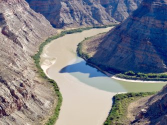
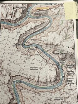
A month from now, we'll be paddling down the Green, and I'm happily compiling info about side hikes. In the RiverMaps guide, there's a description of a hike from "Stove Camp" on Mile 7.0 Left that goes up and then across the flat to an "exquisite view of the Confluence." I would like to see that exquisite view! Have any of you done that? If so, I'd love to hear what it's like.
 
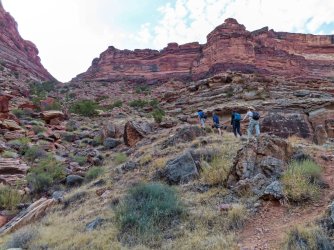
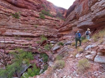
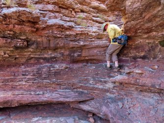
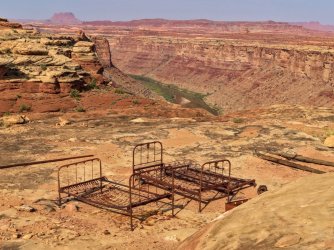
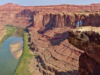
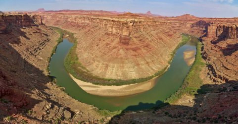
I've done the hike, but only up to the top where a cabin burned down and there are some bed frames and other junk still lying around. I didn't go across the mesa to see the confluence but the views just from the top of the trail were great. There's one spot where you have to climb up a little ledge but otherwise it's not too difficult a hike.

IMG_3887.jpg

IMG_3902.jpg

IMG_3959.jpg

IMG_3922.jpg

IMG_3942.jpg

IMG_3946_stitch.jpg


A few more photos here: http://udink.org/2021/11/08/labyrinth-and-stillwater-canyons-ii/
 
Janice,
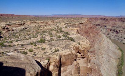
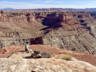
We did a Green/Colorado Cataract Canyon river trip in 2019. On the that trip, we day-hiked to a viewpoint above the Confluence. I don't recognize your reference to Stove Camp; we started hiking on a then unmarked trail about 6.7 river miles from the Confluence. I can send you a gpx of our route if you would like it. The walk was quite easy, with just a tiny bit of scrambling, which may have been bypassable if we had wanted to find an easier approach. The view is well worth the walk. Here are a few images.

James and AmyDSC04514.JPGDSC04521.JPGDSC04522.JPG
 
Last edited:
I've done the hike, but only up to the top where a cabin burned down and there are some bed frames and other junk still lying around. I didn't go across the mesa to see the confluence but the views just from the top of the trail were great. There's one spot where you have to climb up a little ledge but otherwise it's not too difficult a hike.

View attachment 134502

View attachment 134503

View attachment 134507

View attachment 134504

View attachment 134505

View attachment 134506


A few more photos here: http://udink.org/2021/11/08/labyrinth-and-stillwater-canyons-ii/
@Udink, thanks so much for the great info and photos. I just read through the full trip report and found it very helpful. Your photos are terrific - I really hope we get similar weather so I can enjoy the same gorgeous reflections!
 
Janice,
We did a Green/Colorado Cataract Canyon river trip in 2019. On the that trip, we day-hiked to a viewpoint above the Confluence. I don't recognize your reference to Stove Camp; we started hiking on a then unmarked trail about 6.7 river miles from the Confluence. I can send you a gpx of our route if you would like it. The walk was quite easy, with just a tiny bit of scrambling, which may have been bypassable if we had wanted to find an easier approach. The view is well worth the walk. Here are a few images.

James and AmyView attachment 134519View attachment 134521View attachment 134523
Thank you, @James and Amy, for offering the gpx; yes, I would appreciate that very much so I can compare it to what I've got so far. I'm guessing it's the same route. In the river atlas I'm using, here are the map and description:
IMG_2830.jpgIMG_2832.jpg
 
Janice, Attached is a kmz. Hope that you find it useful.
James and Amy
 

Attachments

  • Confluence Point (91419, 25748PM).kmz
    10 KB · Views: 14
Janice, Attached is a kmz. Hope that you find it useful.
James and Amy
Thanks so much. Yes, it's very useful; a lot of it is the same or quite close to what I had drawn on my map based on the RiverMaps route. I notice that you made a little detour to the northeast, I assume to explore the rocks and cliff there. Was there something in particular you were looking for? Or was that just a bit of extra exploration? I'm not sure how much time we'll have, so perhaps we won't be able to do anything extra, but I'm just curious.
 
Janice,
No guarantees, but if I remember correctly, the detour led to some small but reasonably intact Anasazi ruins.
James and Amy
 
Janice,
No guarantees, but if I remember correctly, the detour led to some small but reasonably intact Anasazi ruins.
James and Amy
Thanks - I'll be eager to check it out.

Do you have any DO-NOT-MISS places to hike or explore along Stillwater or lower Labyrinth? If so, I'd love to hear. Same for you, @Udink, or anyone else who might see this. I know there are way too many things to experience in one trip, and hearing from you experts might help me prioritize...
I think this hike is one of the best things to see along that stretch of river--even if you only see the burned cabin location. I'm sure the hike to the confluence view is also well worth it. Definitely stop at Turk's Head to see the ruins there, and stop at Valentine Bottom to see the pictographs (and there are a lot of ruins I think just upstream of there).

Maybe take the "no guarantees Anasazi ruins" with a grain of salt. This site says "I wasn’t able to find any ruins, but there are hundreds of flint flakes scattered across the wash in front of the alcove." I personally would definitely stop to check out that alcove but I wouldn't make it my main destination.
 
Thanks @Udink - great to know all this. I'm glad you linked the hike from Day's website. I have two of his books but not this one, and when I looked at the Canyonlands table of contents online the title of this one didn't jump out at me as being relevant for our trip. I think I'll go back and look more closely at the others!
 
Janice,
I have only taken a single river trip on the Green so am no expert on good hikes there. I suspect that where you can get to will depend a lot on how much time you have off of the water. A good bit of the Green trip is in Canyonlands NP and there is a lot of data available about hiking opportunities within the park. From Spanish Bottom, a good trail leads up into the Doll's House area which is certainly worth the time it takes to get there. Prior to arriving in the park, I would guess that walking up any of the accessible side canyons would provide at least a pleasant day hike.

James and Amy
 
Found this in my files. Dont know if it will help. Dont even remember where I got it, I dont raft anywhere. Save it if it works.....

Click here to view on CalTopo
 
Janice,
I have only taken a single river trip on the Green so am no expert on good hikes there. I suspect that where you can get to will depend a lot on how much time you have off of the water. A good bit of the Green trip is in Canyonlands NP and there is a lot of data available about hiking opportunities within the park. From Spanish Bottom, a good trail leads up into the Doll's House area which is certainly worth the time it takes to get there. Prior to arriving in the park, I would guess that walking up any of the accessible side canyons would provide at least a pleasant day hike.

James and Amy
We're planning to spend 2 nights at Spanish Bottom so we can do a full-day hike up to the Doll House and beyond, ideally as far as the Harvest Scene but that's probably too ambitious a goal. We've got 4 full days on the river and hopefully will get to lots of places along the way. Fingers crossed for good weather! We've never hiked Dead Horse State Park and think we'll be there the day before we put in. I'm sure we'll have lots of unfinished business for a future trip...
 
Found this in my files. Dont know if it will help. Dont even remember where I got it, I dont raft anywhere. Save it if it works.....

Click here to view on CalTopo
Yes, this is VERY helpful. The river atlas shows miles, but I didn't have them marked on Caltopo and Gaia (but wanted them there) so this is great. Plus the camping spots and specific spots for pictographs, granaries, etc. THANK YOU!
 
I'm thinking the black dots not associated with mileage or other names are ruins or petros
 
We're planning to spend 2 nights at Spanish Bottom so we can do a full-day hike up to the Doll House and beyond, ideally as far as the Harvest Scene but that's probably too ambitious a goal. We've got 4 full days on the river and hopefully will get to lots of places along the way. Fingers crossed for good weather! We've never hiked Dead Horse State Park and think we'll be there the day before we put in. I'm sure we'll have lots of unfinished business for a future trip...
Harvest scene from Spanish Bottom and back in a day would be a long hike. Quick check on Caltopo shows it would be roughly 16-17 miles round trip via Chimney Rock. The hiking isn't crazy hard (I've covered that ground during a backpacking trip) but it's not a trivial hike either. Water sources could be an issue also.
 
Harvest scene from Spanish Bottom and back in a day would be a long hike. Quick check on Caltopo shows it would be roughly 16-17 miles round trip via Chimney Rock. The hiking isn't crazy hard (I've covered that ground during a backpacking trip) but it's not a trivial hike either. Water sources could be an issue also.
Yeah, I know - I have a feeling it's do-able even if we don't end up doing it. Maybe if the weather's good and we're not tired the night before we'll plan to get up before dawn and move quickly. We would bring a gallon of water or more per person, plenty of snacks, and headlamps. But if we don't do that, I'm sure we'll still want to do a full day up there and explore beyond the Doll House. I'm looking forward to that no matter what.
 
Harvest scene from Spanish Bottom and back in a day would be a long hike. Quick check on Caltopo shows it would be roughly 16-17 miles round trip via Chimney Rock. The hiking isn't crazy hard (I've covered that ground during a backpacking trip) but it's not a trivial hike either. Water sources could be an issue also.
Funny - I'm rereading relevant parts of Kelsey's book and just came across this: "Most people who call themselves hikers could probably make it to the Harvest Scene pictograph panel in the lower end of Pictograph Fork and back to the river in one day." He has thrown down the gauntlet for me!
 
Back
Top