Stephens Canyon Loop, part of Escalante Overland Route or ?

fossana

Member
Joined
Jan 11, 2018
Messages
934
Weather permitting I am taking the week of the 22nd off and am planning to do at least one multi-day hike in Escalante/Glen Canyon. I did a bunch of research, and the tentative plan is to do the 50ish mile version of the Stephens Canyon Loop (starting from the Jacob Hamblin drop into Coyote Gulch not 40 Mile TH). The other thing I am considering is doing part of the Escalante Overland Route (haven't yet dug into the sections yet). I'm comfortable soloing up to mid 5th class in approach shoes, have decent technical climbing route-finding skills, and have a way to set up a self-shuttle for point-to-point hikes with my dual sport.

Anything feedback or something else I should consider? Looking for something remote, scenic, up to 60 miles and not an endless sand/mud slog. I did Boulder Mail Trail to Death Hollow on a previous trip. thanks
 
Last edited:
The Steven's Canyon Loop is on my bucket list. The 50-mile version you reference is the better-documented version of the two and the one I would take. My research indicates that of course there is some mud and sand but you spend a lot of time walking on the benches above Steven's. My biggest hassle is the poison ivy you have to get through.
 
I was in Coyote Gulch early Nov last year and the poison oak leaves had all dropped off. I didn't get a rash despite walking through a few patches, so hoping I get lucky again this year.
 
Both would be killer. The Steven's loop will feel more "out there" than the overland route for most of the trip. That is except Coyote Gulch, which is a (from what I see online) a complete shit show these days. The further away you get from the Escalante river, the better in my experience. There is always a big group on the river (almost anywhere too!), which ruins the feeling that I'm going for.

@John Morrow is a member here (the link you provided for Steven's). If you don't own Steve Allen's Canyoneering 2/3, you should own it for either of those trips. He's the original author of the Steven's loop and an indispensable resource. You could add a lot to the Steven's loop, I've got a 15 day or so trip planned up there when I get the time.
 
Either would be good. The Stevens stuff is great. I've done a few variations but my fav was starting from Halls Crk narrows and returning over the Red Slide but that ended up being more in the ~100 mi. range IIRC (and to be honest probably had a bit more river bashing than I'd be interested in these days).
Another option for endless opportunities is drop down to the Waterpocket Fold from either of the Halls Creek trailheads or the Kingdom TH for Poe/Happy Dog/etc...from there either pick your way up to the top of the Fold and head south as far as you want, pick your way down and return down along the base of the fold or vice versa. Glorious.
 
Thanks, slc_dan. I have the Steve Allen books. Coyote Gulch was fairly quiet last fall, but I went mid-week. I'll look into those, Brendan S.
 
I think I might save the Poe trip for some future attempt at Singing Cricket after I get my potshot launching skills honed.
 
I think I might save the Poe trip for some future attempt at Singing Cricket after I get my potshot launching skills honed.

@Brendan S isn't talking about doing the technical portion of Poe, rather use the approach for Poe to get up the fold. At least I think so.

I'm not really interested in the tough technical canyons-despite being a bit of a climber. I do study their routes though, because it can take you to interesting areas where there isn't a trail.
 
How about combining the two? From hamblin arch up Steven's, up halls creek to lower muley. Overlnd from cowboy cave to choprock, down choprock, take the overland route back to coyote. Now that I would like to try.
 
How about combining the two? From hamblin arch up Steven's, up halls creek to lower muley. Overlnd from cowboy cave to choprock, down choprock, take the overland route back to coyote. Now that I would like to try.
Thanks, definitely something worth exploring. I'd have to map out mileage.
 
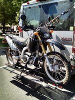
I use my Yamaha WR250 for shuttling and more technical rides, but also have a BMW F650GS. My shuttle setup:IMG_20160401_130037.jpg
 
  • Like
Reactions: Ben
I hope your trip went well. I came across your post earlier this year while researching the Escalante Overland Route. We did a section of the Overland Route a few weeks ago and had an amazing time (snow surprise included). Just wanted to let you know your post was inspiring (massively!).
 
Thanks @Spiderwoman! Which section did you do? The Shofar/Hydra/Ichabod section seems the most worth of reconning.
 
Last edited:
Thanks @Spiderwoman! Which section did you do? The Shofar/Hydra/Ichabod section seems the most worth of reconning.

Hi fossana! I hope you're well. It's nice hearing from you.

We started at BMT TH in Escalante. Left the trail after Death Hollow and went xcountry down into Calf Creek. Walked up the highway. Then started Allen's route. Exited at Harris Wash (took his 5.0 exit up to the canyon rim to get out of the quicksand). Hitched back on HITR Rd. So we didn't get into the thick of it, none of the stuff you mentioned. That's for 2020. Can not wait for it to get real and to feel those butterflies.

What have you done on the Escalante Overland Route? I'm so impressed that you do this stuff solo.
78932
 
Thank you @Spiderwoman. That sounds like a great trip, quicksand and all. I've only done the parts that overlap with Stephens/Fold, which was super fun (minus the bushwhack along the Escalante). I have the approximate EO route mapped on topo maps and am planning to check out the section I mentioned next.
 
Thank you @Spiderwoman. That sounds like a great trip, quicksand and all. I've only done the parts that overlap with Stephens/Fold, which was super fun (minus the bushwhack along the Escalante). I have the approximate EO route mapped on topo maps and am planning to check out the section I mentioned next.

Escalante bushwacking...cringing for ya. We did continuous days of it in '14 between Middle Moody and Coyote Gulch. Left scars (leg and brain). Are you planning on a fall trip? Definitely keep me in the loop, post pictures, I'm beyond interested.
 
Back
Top