Cody
Member
- Joined
- Mar 4, 2012
- Messages
- 100
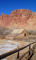
I took a two-nighter last fall to explore some nice areas of Capitol Reef along the Highway 24 corridor of the park. It was November, there was fresh snow and some question whether I could complete the route, but I had good early exit options for all of the places where I might have had trouble with snow + exposure. The plan: Upper and Lower Spring Canyon, and looping back via Grand Wash and the Frying Pan Trail.

I parked at Holt Draw Road, just east of Torrey and followed the upper tributaries of Sulphur Creek.

Along the way, I admired a number of petrified logs poking out of the canyon walls and laying across the ground.


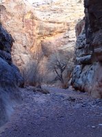
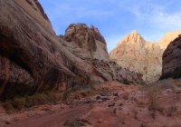
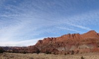
Access to Upper Spring Canyon is through this notch of the "W" which is a fairly easy scramble, followed by a descent into Spring Canyon that is a little more involved but by no means horrible.

After getting into Spring Canyon, I climbed up high on the north slope to find a lunch perch for some perspective and good views of my route down canyon.

After a nice break I got moving down the canyon and more snow caught up with me and stuck with me for a lot of the afternoon. The floor of Upper Spring Canyon is full of boulders and negotiating them in the wet snow wasn't my favorite thing. This section took me a lot longer than I had planned.

The storm eventually lifted.


I eventually found a nice sandy bench to pitch my fly in the event of more snow. There was a LOT of new rockfall in the canyon. I was keen on avoiding getting flattened overnight so I picked a spot where I was confident there wasn't any thing going to come loose from above.
The next morning I came across this scene just down stream from my camp. Falling boulders had just pulverized this big Fremont Cottonwood. The dust from the event was sitting fresh on top of the new snow. It was as if the tree had exploded. Very impressive. The photo doesn't quite give you the depth, but where the two biggest rocks sit on the left is actually quite a nice crater where the tree used to live.

It took a bit of walking that morning before by shoes were fully thawed. When the first rays of sun finally reached down into the canyon it was NICE. I had a long breakfast up on a sunny slope and then headed further down canyon and pulled some water from the spring for the next couple days. I was going to cross the Fremont River later that day, but didn't really want to deal with the silt, nor was I sure if melted snow would be an option further on, so I filled up all my platy bags here.

View attachment 9921


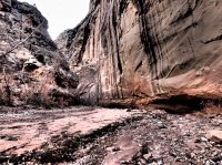
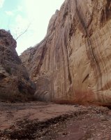
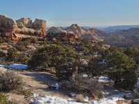
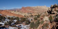
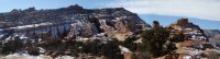
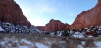
The section below the spring is lovely, although would be much nicer if the cottonwoods still had color on them. Below the spring, Chimney Rock Canyon intersects Spring Canyon and there's a route back to Highway 24 if hikers are only doing one section of Spring Canyon. Past that junction, going down into Lower Spring Canyon, you find a totally different kind of beauty. Big white domes, spires and slots. There is one section that requires a bypass of a series of dry falls. It is on a steep, loose slope and the path across is foot-width in places. This is the section I was most concerned about with the snow, but it didn't turn out to be a problem.


Lower Spring Canyon was my favorite section of the hike and I need to go back and hike it in warmer weather as a day loop with Chimney Rock Canyon when I can go at a more leisurely pace.


Spring Canyon ends at the Fremont River right alongside Highway 24 toward the east end of the park. I forded the Fremont River at just over knee depth. Needless to say, quite cold and also surprisingly swift for that time of year. From there, I walked east on the highway and then up Grand Wash at dusk.

The second night of my permit was up along the Frying Pan Trail. That meant climbing up and out of Grand Wash along the Cassidy Arch trail in the dark--which turned out to be a really neat night hike--and thankfully mostly free of snow.

I got up on the Frying Pan and walked for 20 or so minutes in the dark and then dropped camp. I was in for another very cold night, but I had enough time hiking since fording the Fremont that my shoes and pants were mostly dry.
The next morning I had only to hike a short ways down to Fruita via Cohab Canyon so I lingered as the sun warmed up my camp and I enjoyed some breakfast in bed. My improvised camp booties helped to fend off the cold as I cleaned up.


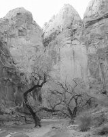
Once I finally got moving I was in for some more great Capitol Reef scenery all the way down to Fruita.


From Fruita, I anticipated hitchhiking back to Holt Draw Road. In retrospect though, hitching a desert highway, in Utah, in the off season, on a Monday... not the best bet. I got one short hitch: from Fruita C.G. to the Visitor Center and ended up walking almost all of the rest of the way back to Torrey. Only a dozen or so cars passed me along the way and no takers among them. I might have had better luck if I'd hung out at the VC parking lot to chat it up rather than walking down the highway with my thumb out.

Great hike. With a little more time (and warmer weather), I would have liked to tack on another section to the end of the loop: Sulpher Creek. It's 5 miles, and comes out right at Chimney Rock; shortens the shuttling/hitching/road hiking needed to complete the loop.
Featured image for home page:

I parked at Holt Draw Road, just east of Torrey and followed the upper tributaries of Sulphur Creek.
Along the way, I admired a number of petrified logs poking out of the canyon walls and laying across the ground.
Access to Upper Spring Canyon is through this notch of the "W" which is a fairly easy scramble, followed by a descent into Spring Canyon that is a little more involved but by no means horrible.
After getting into Spring Canyon, I climbed up high on the north slope to find a lunch perch for some perspective and good views of my route down canyon.
After a nice break I got moving down the canyon and more snow caught up with me and stuck with me for a lot of the afternoon. The floor of Upper Spring Canyon is full of boulders and negotiating them in the wet snow wasn't my favorite thing. This section took me a lot longer than I had planned.
The storm eventually lifted.
I eventually found a nice sandy bench to pitch my fly in the event of more snow. There was a LOT of new rockfall in the canyon. I was keen on avoiding getting flattened overnight so I picked a spot where I was confident there wasn't any thing going to come loose from above.
The next morning I came across this scene just down stream from my camp. Falling boulders had just pulverized this big Fremont Cottonwood. The dust from the event was sitting fresh on top of the new snow. It was as if the tree had exploded. Very impressive. The photo doesn't quite give you the depth, but where the two biggest rocks sit on the left is actually quite a nice crater where the tree used to live.
It took a bit of walking that morning before by shoes were fully thawed. When the first rays of sun finally reached down into the canyon it was NICE. I had a long breakfast up on a sunny slope and then headed further down canyon and pulled some water from the spring for the next couple days. I was going to cross the Fremont River later that day, but didn't really want to deal with the silt, nor was I sure if melted snow would be an option further on, so I filled up all my platy bags here.
View attachment 9921
The section below the spring is lovely, although would be much nicer if the cottonwoods still had color on them. Below the spring, Chimney Rock Canyon intersects Spring Canyon and there's a route back to Highway 24 if hikers are only doing one section of Spring Canyon. Past that junction, going down into Lower Spring Canyon, you find a totally different kind of beauty. Big white domes, spires and slots. There is one section that requires a bypass of a series of dry falls. It is on a steep, loose slope and the path across is foot-width in places. This is the section I was most concerned about with the snow, but it didn't turn out to be a problem.
Lower Spring Canyon was my favorite section of the hike and I need to go back and hike it in warmer weather as a day loop with Chimney Rock Canyon when I can go at a more leisurely pace.
Spring Canyon ends at the Fremont River right alongside Highway 24 toward the east end of the park. I forded the Fremont River at just over knee depth. Needless to say, quite cold and also surprisingly swift for that time of year. From there, I walked east on the highway and then up Grand Wash at dusk.
The second night of my permit was up along the Frying Pan Trail. That meant climbing up and out of Grand Wash along the Cassidy Arch trail in the dark--which turned out to be a really neat night hike--and thankfully mostly free of snow.
I got up on the Frying Pan and walked for 20 or so minutes in the dark and then dropped camp. I was in for another very cold night, but I had enough time hiking since fording the Fremont that my shoes and pants were mostly dry.
The next morning I had only to hike a short ways down to Fruita via Cohab Canyon so I lingered as the sun warmed up my camp and I enjoyed some breakfast in bed. My improvised camp booties helped to fend off the cold as I cleaned up.
Once I finally got moving I was in for some more great Capitol Reef scenery all the way down to Fruita.
From Fruita, I anticipated hitchhiking back to Holt Draw Road. In retrospect though, hitching a desert highway, in Utah, in the off season, on a Monday... not the best bet. I got one short hitch: from Fruita C.G. to the Visitor Center and ended up walking almost all of the rest of the way back to Torrey. Only a dozen or so cars passed me along the way and no takers among them. I might have had better luck if I'd hung out at the VC parking lot to chat it up rather than walking down the highway with my thumb out.
Great hike. With a little more time (and warmer weather), I would have liked to tack on another section to the end of the loop: Sulpher Creek. It's 5 miles, and comes out right at Chimney Rock; shortens the shuttling/hitching/road hiking needed to complete the loop.
Featured image for home page:
Attachments
-
 PC160165.JPG215.4 KB · Views: 29
 -
 PC160168.JPG224.3 KB · Views: 28
 -
 PC160171.JPG160.6 KB · Views: 28
 -
 PC160174.JPG185 KB · Views: 29
 -
 PC160179.JPG105.5 KB · Views: 29
 -
 PC170209.JPG148.6 KB · Views: 28
 -
 PC170222.JPG107.4 KB · Views: 29
 -
 PC170238.JPG62.7 KB · Views: 28
 -
 PC170277.JPG154.5 KB · Views: 29
 -
 PC170286.JPG71.9 KB · Views: 30
 -
 PC150104.JPG77.9 KB · Views: 25
")