Kullaberg63
Member
- Joined
- Mar 6, 2014
- Messages
- 673
Not to be confused with Roper’s classic Sierra High Route, the shorter SoSHR explores challenging terrain parallel to the John Muir Trail from Bishop Pass to an exit south of Mt Whitney
This stretch of the Sierra Crest is the highest and most inaccessibly rugged of the range. 13 of California’s 15 unofficial peaks over 14k’ lies along this route
The SoSHR is 90 miles long with 35k’ feet of gain and took my son and I ten days including climbing Whitney, Langley and attempting Russell, three of the 14ers. I’m in my sixties and felt this to be a reasonable time frame without getting too beat up
We skipped resupplying, but to keep our starting pack weight around thirty pounds with 10 days of food we carefully evaluated all the gear. The nights in the Sierra in August are warm and the days downright hot, even at 13000’, plus summer storms are rare. Snow travel was not an issue this season, yet water is abundant from hundreds of alpine lakes. All this helped trimming the gear to a bare minimum
Being entirely in Kings-Sequoia National Parks sadly meant leaving Skotti Dog behind. But I knew the difficulty of this route would not be dog friendly at all, plus it saved me from carrying an additional 5-6 lbs of dog food
Map: Click here to view on CalTopo

We started on the Bishop Pass trail, an important Sierra Crest crossing. It’s a quota permit entry that takes impeccable timing and swift keyboard strokes to secure

Battling appetite loss and nausea at the 12000’ altitude of camp one

Classic Sierra off trail travel characterized the terrain around the three passes of early day two: Thunderbolt, Potluck and Cirque. After lunch we merged with the JMT for an afternoon crossing of Mather Pass.

Starting to adjust to the altitude; evening day two

Morning day three in exquisite Upper Basin


Day 4 had the mental crux of the entire route: the Baxter Traverse. From Sawmill Pass to finally arriving at the massive lake near the extinct Baxter Pass trail were 5 hours of steep, shifting microwave sized talus mixed with a few very exposed blocky climbs, all demanding constant focus.
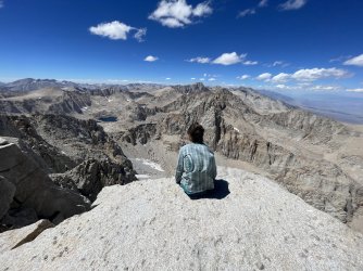
Halfway thru, on the summit plateau of Baxter Peak at 13200’ we spotted a herd of 20-25 California Bighorn Sheep.

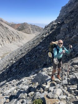
Fixing blown out heel cups after the 2000’ talus gully descent off Baxter which we stand at the top of in the second image above

Clarence King from our camp in Sixty Lakes Basin, which we traversed in full as an alternate to neighboring Rae Lakes. The latter is arguably the busiest destination in this part of the Sierra, while intimate 60 Lakes was deserted and allowed a complete bypass of Rae Lakes

After hitting Glen Pass near the top exit from Sixty Lakes it was JMT hiking until lonely Center Basin, here seen as the left forested arm of upper Bubbs Creek.

The JMT used to go thru Center Basin before the Forester Pass trail was finished in 1932. Now it’s a remote valley with only a faint path. We heard coyotes and watched mallards in the lake and sandpipers along the marshes. Probably the finest location on the whole tour, and we had it to ourselves

Before Forester the JMT used Junction Pass, which today is a totally forgotten and barely visible path from Center Basin over the actual Sierra Crest to below Shepherd Pass on the east side. This was another significant challenge of the SoSHR.

We are now nearing the last of the major difficult sections by entering the Whitney region via the remote back door of upper Wallace and finally the Russell Carillon Col

Before climbing the RC col one walks the shore of Tulainyo, at right, the highest lake of its size in the US. It was incredibly clear and untouched. Two coyotes hung out nearby while we filled our bottles

The SoSHR takes the Mountaineers Route on Whitney, seen as the foreshortened gully to a notch on the right, before following the regular hiking route towards Trail Crest


Four images from the Mountaineers Route. The main gully from Iceberg Lake is relatively easy and fast, but after the notch things get confusing. We opted for solid looking rock instead of lower angled loose blocks.

The morning of our Whitney climb was followed by a pretty challenging afternoon of steep scree around Crabtree Pass, so when we arrived a Skyblue Lake at 4pm we collapsed at the shore and napped for several hours. After coming to at 7pm we cooked and then slept another 11 hrs!

Skyblue, on day 8, marks the end of the real difficulties. The remaining 2 days dealt with beautiful Miter Basin, the Langley slog to fantastic views, the wild and rugged Old Army Pass, plus a surprisingly smooth 80 mile hitchhike back to Bishop Pass trailhead.
Overall a very good route with lots of cruiser miles in some of the best Sierra terrain. The spicy bits were more interesting than loathsome. We had a good time, and didn’t beat up ourselves as much as we sometimes do.
This stretch of the Sierra Crest is the highest and most inaccessibly rugged of the range. 13 of California’s 15 unofficial peaks over 14k’ lies along this route
The SoSHR is 90 miles long with 35k’ feet of gain and took my son and I ten days including climbing Whitney, Langley and attempting Russell, three of the 14ers. I’m in my sixties and felt this to be a reasonable time frame without getting too beat up
We skipped resupplying, but to keep our starting pack weight around thirty pounds with 10 days of food we carefully evaluated all the gear. The nights in the Sierra in August are warm and the days downright hot, even at 13000’, plus summer storms are rare. Snow travel was not an issue this season, yet water is abundant from hundreds of alpine lakes. All this helped trimming the gear to a bare minimum
Being entirely in Kings-Sequoia National Parks sadly meant leaving Skotti Dog behind. But I knew the difficulty of this route would not be dog friendly at all, plus it saved me from carrying an additional 5-6 lbs of dog food
Map: Click here to view on CalTopo
We started on the Bishop Pass trail, an important Sierra Crest crossing. It’s a quota permit entry that takes impeccable timing and swift keyboard strokes to secure
Battling appetite loss and nausea at the 12000’ altitude of camp one
Classic Sierra off trail travel characterized the terrain around the three passes of early day two: Thunderbolt, Potluck and Cirque. After lunch we merged with the JMT for an afternoon crossing of Mather Pass.
Starting to adjust to the altitude; evening day two
Morning day three in exquisite Upper Basin
Day 4 had the mental crux of the entire route: the Baxter Traverse. From Sawmill Pass to finally arriving at the massive lake near the extinct Baxter Pass trail were 5 hours of steep, shifting microwave sized talus mixed with a few very exposed blocky climbs, all demanding constant focus.
Halfway thru, on the summit plateau of Baxter Peak at 13200’ we spotted a herd of 20-25 California Bighorn Sheep.
Fixing blown out heel cups after the 2000’ talus gully descent off Baxter which we stand at the top of in the second image above
Clarence King from our camp in Sixty Lakes Basin, which we traversed in full as an alternate to neighboring Rae Lakes. The latter is arguably the busiest destination in this part of the Sierra, while intimate 60 Lakes was deserted and allowed a complete bypass of Rae Lakes
After hitting Glen Pass near the top exit from Sixty Lakes it was JMT hiking until lonely Center Basin, here seen as the left forested arm of upper Bubbs Creek.
The JMT used to go thru Center Basin before the Forester Pass trail was finished in 1932. Now it’s a remote valley with only a faint path. We heard coyotes and watched mallards in the lake and sandpipers along the marshes. Probably the finest location on the whole tour, and we had it to ourselves
Before Forester the JMT used Junction Pass, which today is a totally forgotten and barely visible path from Center Basin over the actual Sierra Crest to below Shepherd Pass on the east side. This was another significant challenge of the SoSHR.
We are now nearing the last of the major difficult sections by entering the Whitney region via the remote back door of upper Wallace and finally the Russell Carillon Col
Before climbing the RC col one walks the shore of Tulainyo, at right, the highest lake of its size in the US. It was incredibly clear and untouched. Two coyotes hung out nearby while we filled our bottles
The SoSHR takes the Mountaineers Route on Whitney, seen as the foreshortened gully to a notch on the right, before following the regular hiking route towards Trail Crest
Four images from the Mountaineers Route. The main gully from Iceberg Lake is relatively easy and fast, but after the notch things get confusing. We opted for solid looking rock instead of lower angled loose blocks.
The morning of our Whitney climb was followed by a pretty challenging afternoon of steep scree around Crabtree Pass, so when we arrived a Skyblue Lake at 4pm we collapsed at the shore and napped for several hours. After coming to at 7pm we cooked and then slept another 11 hrs!
Skyblue, on day 8, marks the end of the real difficulties. The remaining 2 days dealt with beautiful Miter Basin, the Langley slog to fantastic views, the wild and rugged Old Army Pass, plus a surprisingly smooth 80 mile hitchhike back to Bishop Pass trailhead.
Overall a very good route with lots of cruiser miles in some of the best Sierra terrain. The spicy bits were more interesting than loathsome. We had a good time, and didn’t beat up ourselves as much as we sometimes do.
Attachments
Last edited:
") But your photos make it look awesome
But your photos make it look awesome