fossana
Member
- Joined
- Jan 11, 2018
- Messages
- 1,035
The Route
South Guardian Angel is prized among Zion peak baggers due to its relatively remote location and challenging approach. For your grovelfest you are rewarded with an ascent up lovely sandstone and breathtaking views that few will ever see.I hiked the 3rd class NE Ridge back in April 2018. There is a short section of 4th class on the approach out of the creek bed.
I put detailed beta on Mt Project.
The cross-country route from the small pink dome near North Guardian to the base of South Guardian.

Logistics
Start/end Trailhead: Wildcat Canyon trailhead off of Kolob Terrace Road (shuttle required for optional Subway descent which ends the Left Fork trailhead)
Mileage: ~15 miles
Elevation gain: ~2900 ft
Navigation: GPS suggested, some cairns
Filterable water: most reliable water in North Creek
Permits: visitor required for overnight trips or with the optional Subway +/- Russell Gulch exit
Bathrooms: parking lot
Dogs: not allowed
Nearest town/gas: La Verkin, UT (gas); Virgin (food, seasonal)
Photos
Passing by one of the Northgate Peaks.

North Guardian Angel

One of the smaller domes as you head toward the pink bump that marks the descent into the Subway.

Rounding the base of North Guardian to see South Guardian, just a major drainage away.

Crossing the Left Fork of North Creek (a.k.a. the Subway).

The Jughandle Arch (how you know you crossed the creek at the right place).

Heading up from the valley onto the toe of South Guardian Angel.

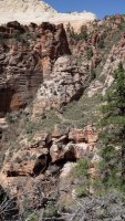
the hoodoo section

Passing the big hoodoo.

The little vegetated ledge before the final push to the summit.


your reward

Closer view of North Guardian Angel.

The grovelly ascent out of North Creek on the way back.

Out of the drainage

South Guardian Angel is prized among Zion peak baggers due to its relatively remote location and challenging approach. For your grovelfest you are rewarded with an ascent up lovely sandstone and breathtaking views that few will ever see.I hiked the 3rd class NE Ridge back in April 2018. There is a short section of 4th class on the approach out of the creek bed.
I put detailed beta on Mt Project.
The cross-country route from the small pink dome near North Guardian to the base of South Guardian.
Logistics
Start/end Trailhead: Wildcat Canyon trailhead off of Kolob Terrace Road (shuttle required for optional Subway descent which ends the Left Fork trailhead)
Mileage: ~15 miles
Elevation gain: ~2900 ft
Navigation: GPS suggested, some cairns
Filterable water: most reliable water in North Creek
Permits: visitor required for overnight trips or with the optional Subway +/- Russell Gulch exit
Bathrooms: parking lot
Dogs: not allowed
Nearest town/gas: La Verkin, UT (gas); Virgin (food, seasonal)
Photos
Passing by one of the Northgate Peaks.
North Guardian Angel
One of the smaller domes as you head toward the pink bump that marks the descent into the Subway.
Rounding the base of North Guardian to see South Guardian, just a major drainage away.
Crossing the Left Fork of North Creek (a.k.a. the Subway).
The Jughandle Arch (how you know you crossed the creek at the right place).
Heading up from the valley onto the toe of South Guardian Angel.
the hoodoo section
Passing the big hoodoo.
The little vegetated ledge before the final push to the summit.
your reward
Closer view of North Guardian Angel.
The grovelly ascent out of North Creek on the way back.
Out of the drainage