Slickhorn Canyon Question

mike_offerman

Member
Joined
Feb 8, 2012
Messages
547
I was wondering if anyone would be able to mark the different forks of Slickhorn Canyon. Was planning on doing a longer loop hike down there in a few weeks.

Any suggestions on what loop hike would be appreciated. Looking for a nice long and challenging hike.

How about good camping in the area? Should have a 4x4.

Might have time to hike around the Hat Flat area. Any specific destinations there? Or just wander around?
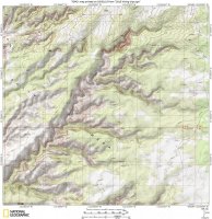
slickhorn.JPG
 
A lot of basic as well as detailed info can be found on the internet:
for instance John Crossley's site has info/maps on lots of canyons, including Slickhorn, the map mentions the different Forks.
http://www.americansouthwest.net/utah/cedar-mesa-grand-gulch/slickhorn-canyon.html

This and more info and maps can be found in the books of David Day
http://www.utahtrails.com/Index.html
Several pages can be read on the internet, but the book includes the map
http://www.utahtrails.com/Backcountry pages/Slickhorn.html

* AMAZON and GOOGLE previews below give limited online access to some Books. *
They don't have all the bookpages and moreover only allow you to look at a limited number of pages, so when finding a page of interest, first look on the previous and next pages that are relevant to your subject.

"Hiking from Here to Wow!" also has a map/info see the Google Books preview :
https://books.google.nl/books?id=6D...QaqoYCIDw&ved=0CFcQ6AEwBw#v=onepage&q&f=false

Hiking Grand Staircase-Escalante and the Glen Canyon Region by Ron Adkinson (Falcon Guide), see Amazon Preview and type Slickhorn in the search field
http://www.amazon.com/dp/1560446455/?tag=backcountrypo-20

Info/map on Slickhorn (and tons of other Canyons) also in Kelsey's:
"Non-Technical Canyon Hiking Guide to the Colorado Plateau, 6th Edition".
Here is an overview of all his Books
http://kelseyguidebooks.com/

When you get some of the relevant titles you can spend the rest of your life finding and hiking interesting Canyons and more.
Hope this helps as a start.
 
There are 4 access points to Slickhorn, the BLM should have free maps that shows them, ending at Slickhorn 4 which is identified by a corral on your right where you park. Many options here for loop hikes up and down Slickhorn, my favorite being a hike down Slickhorn 4 to the San Juan, hike down to Point Lookout (the next canyon down) and back up to the head of the left fork of Pt. Lookout, which will be just down the road from your car at Slickhorn 4. Hat Flat is a nice little area with small finger canyons. Here is a link to my report to Hat Flat a few winters ago:
http://backcountrypost.com/threads/hat-flat-cedar-mesa.1633/
 
Last edited:
Get the trails Illustrated map of GG.
Here is a few links I have from the web:

http://www.southwestguidebooks.com/trip_guide_pages/cedarmesa_slickhorn1_2.htm
https://southwestbackcountry.wordpress.com/2009/12/25/slickhorn-canyon-ruins-ut/
http://www.twohikers.org/CanyonCountry/Slickhorn97/sh_day7.htm

Most of te ruins are in the upper three forks.
You will have to get permits at Kane Creek Station, before noon. (see my post in the resource section on Grand Gulch). They can give you info on Slickhorn as well.

Can't see good on your map but can camp east of the second fork from top on main road at junction where a spur goes to a drill hole.
 
Last edited:
Thanks for all the suggestions. Will check out some of the books and keep digging around on the internet. Can't wait to get down there!
 
Back
Top