UtahBrian
God bless America. Let's save some of it.
- Joined
- Feb 15, 2018
- Messages
- 54
On 12 March 2019, President Trump signed the John Dingell Conservation, Management, and Recreation Act, creating 661,155 acres of BLM wilderness in Emery County, Utah. Most of the land that became wilderness was first set aside for study as wilderness-quality after research done under the FLPMA law of 1976. So we'd been waiting 43 years for permanent wilderness protection for the crown jewels of the San Rafael Swell and now we have some. I went backpacking to celebrate.
It took me until November to get out there and the weather was interesting. It was over 40ºF most days and around 20ºF each night. No significant snowfall until the fourth and final day. It was typical mild late fall weather for the region, where the weather is favorable almost every month of the year (but check weather reports carefully before visiting in January or July).
I parked a car about a mile up the San Rafael River from the Swinging Bridge and started hiking upstream in the late afternoon and made camp three miles later at the mouth of Cane Wash. The site was two miles into our new Sids Mountain Wilderness, where I would spend the next four days.
It was axle grease mud all along the San Rafael River and my shoes were quite muddy and slippery over the steep parts, which wasn't ideal, but Cane Wash was wonderfully full of soft walking gravel.

I started up Cane Wash a few minutes before dawn. Because daylight is scarce and valuable in late November, you have to make camp at sunset and then have dinner in the dark, read a little, sleep, wake up in the dark, make breakfast in the dark, and break camp in the dark. Remember to bring a headlamp with fresh batteries.
The route goes up the canyon wall on the right above and scrambles a few hundred vertical feet to a break in a knife-edge ridge.

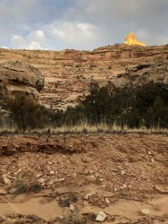
From the knife-edge ridge, you can look up at the highest westernmost viewpoint trail of the Wedge Overlook, a popular primitive car camping and scenic spot in the Swell. You can't see any roads, trails, or people up there and they can't get down the cliff to here, but this land is so beautiful that hundreds of people enjoy it from above every day even though you can have all of it to yourself as a hiker.

It was about 20ºF each morning, but rose up above freezing in a couple hours (except on the last day).

The hiking was excellent on the hills and ridges.

But it was muddy by the river once the ice melted.

I wasn't the first one here. Wonder what that guy is doing to that ungulate on the right.

Places in the shade had better hiking all day. Not as much mud.

Eventually I made it through the mud to Virgin Springs Canyon.

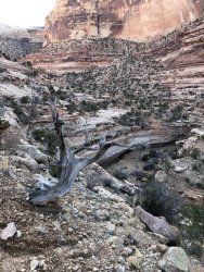
Virgin Springs Canyon is inaccessible to cattle so it's full of native bunch grasses, willows, cryptogams, and the natural desert.

I camped in Virgin Springs Canyon at the end of day two and woke up to a lazy morning day hiking up the high ledges.

Had to find a big rock to get into the fresh clean spring water.

There were a variety of ledge systems to climb and explore above the canyon floor.

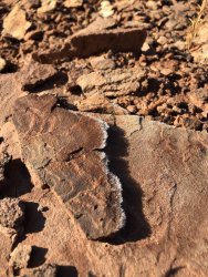
I found this on a steep ledge about 100 feet above the canyon floor. It required a scramble to get up here from any side and the drainages immediately above don't wash debris down here. This was the only sign of modern human activity I saw on the third day.

Virgin Springs Canyon around sunset.

I was up on the trail before dawn again on the fourth day for the hike out. There were pretty frost flowers.

The way up the pass was steep (Thanks to Steve Allen for good directions).

And the pass had a very big view.

The neck of No Mans Mountain.

The snow started falling about the time I made the summit and there were a lot of steep ledge traverses to go so I hurried.
This is the trail down.

And a bit of the traverse. You descend this on the far side. (This is the easy way down. The other way is not recommended when there is frost because it's too steep.)

The snow would pick up sometimes.

And then die away to almost nothing.

There was water in the springs on Cane Wash and some stream flow on the way out. Just ten easy hiking miles after the traverse over the pass.

Cane Wash is pretty, though Virgin Springs is the star.

The snow picked up on the way out. Several inches fell overnight. But I was on my way home. This is what it looked like with two miles left to hike. I had to put my sweater back on around here.

It took me until November to get out there and the weather was interesting. It was over 40ºF most days and around 20ºF each night. No significant snowfall until the fourth and final day. It was typical mild late fall weather for the region, where the weather is favorable almost every month of the year (but check weather reports carefully before visiting in January or July).
I parked a car about a mile up the San Rafael River from the Swinging Bridge and started hiking upstream in the late afternoon and made camp three miles later at the mouth of Cane Wash. The site was two miles into our new Sids Mountain Wilderness, where I would spend the next four days.
It was axle grease mud all along the San Rafael River and my shoes were quite muddy and slippery over the steep parts, which wasn't ideal, but Cane Wash was wonderfully full of soft walking gravel.
I started up Cane Wash a few minutes before dawn. Because daylight is scarce and valuable in late November, you have to make camp at sunset and then have dinner in the dark, read a little, sleep, wake up in the dark, make breakfast in the dark, and break camp in the dark. Remember to bring a headlamp with fresh batteries.
The route goes up the canyon wall on the right above and scrambles a few hundred vertical feet to a break in a knife-edge ridge.
From the knife-edge ridge, you can look up at the highest westernmost viewpoint trail of the Wedge Overlook, a popular primitive car camping and scenic spot in the Swell. You can't see any roads, trails, or people up there and they can't get down the cliff to here, but this land is so beautiful that hundreds of people enjoy it from above every day even though you can have all of it to yourself as a hiker.
It was about 20ºF each morning, but rose up above freezing in a couple hours (except on the last day).
The hiking was excellent on the hills and ridges.
But it was muddy by the river once the ice melted.
I wasn't the first one here. Wonder what that guy is doing to that ungulate on the right.
Places in the shade had better hiking all day. Not as much mud.
Eventually I made it through the mud to Virgin Springs Canyon.
Virgin Springs Canyon is inaccessible to cattle so it's full of native bunch grasses, willows, cryptogams, and the natural desert.
I camped in Virgin Springs Canyon at the end of day two and woke up to a lazy morning day hiking up the high ledges.
Had to find a big rock to get into the fresh clean spring water.
There were a variety of ledge systems to climb and explore above the canyon floor.
I found this on a steep ledge about 100 feet above the canyon floor. It required a scramble to get up here from any side and the drainages immediately above don't wash debris down here. This was the only sign of modern human activity I saw on the third day.
Virgin Springs Canyon around sunset.
I was up on the trail before dawn again on the fourth day for the hike out. There were pretty frost flowers.
The way up the pass was steep (Thanks to Steve Allen for good directions).
And the pass had a very big view.
The neck of No Mans Mountain.
The snow started falling about the time I made the summit and there were a lot of steep ledge traverses to go so I hurried.
This is the trail down.
And a bit of the traverse. You descend this on the far side. (This is the easy way down. The other way is not recommended when there is frost because it's too steep.)
The snow would pick up sometimes.
And then die away to almost nothing.
There was water in the springs on Cane Wash and some stream flow on the way out. Just ten easy hiking miles after the traverse over the pass.
Cane Wash is pretty, though Virgin Springs is the star.
The snow picked up on the way out. Several inches fell overnight. But I was on my way home. This is what it looked like with two miles left to hike. I had to put my sweater back on around here.