- Joined
- May 24, 2015
- Messages
- 179
Covid lockdown time is good for catching up on old trip reports. This trip occurred in 2010 and was originally documented in a YNP online forum. That website had a virus, crashed, and was not backed up, so all of the trip reports were lost.  I had my own copy of this one and every once in a while, scout leaders will ask me what happened to that Shoshone canoe trip report they used as reference for their kids. So I am reproducing it here. Fortunately not much has changed.
Shoshone geyser basin is a 17 mile round trip hike from the Lone Star trail area. Our Bakentine camping group ( Two families, each with three daughters ) likes being on the water, so we took an alternative route and chose to paddle canoes into the remote basin area, starting from the Lewis Lake campground.

We arranged for campsites on Shoshone Lake for two nights, this plan helped to break up the paddling into a comfortable 28 miles spread over three paddling days. The most critical part of this trip (as usual) was getting the backcountry permits for the campsites. Once we had confirmation of those, everything else fell into place quite easily. Since we were coming from out of state, we rented canoes in Jackson. We tried Leisure Sports this time, as they offered a better deal than Snake River Kayak. With our group of ten, we needed five canoes with a trailer and Leisure was able to provide this. We also rented our tow vehicle from them, which was a little shaky (bald tires, noisy) but, it was cheap and convenient. You get what you pay for.
It is critical to get an early start on any of the paddling days to avoid the afternoon winds that can develop on the cold lakes. We made sure to get Lewis Lake campsites for the night before the trip and also to have picked up our permits and viewed the mandatory backcountry video, the day before our paddle departure.
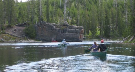
The trip consists of a three mile paddle across Lewis Lake, then a three mile journey up the Lewis channel. The last mile of this upstream paddle becomes too shallow and too steep, requiring the canoes to be hand lined up to Shoshone Lake. Our reserved campsites were upwind another three miles along the South shore of Shoshone Lake. The second day’s paddle, with the canoes unburdened, was about 8 miles to and from the Shoshone Geyser basin. The return portion of this trip was with the afternoon breeze at our back. Day three would be an enjoyable paddle off of Shoshone lake, then back down the channel, (no lining required) and then following the west Shore of Lewis Lake, back to the boat dock.
There are no fires allowed at the campsites and there are no bear lockers, but there is a food pole and pit toilet provided. Not needing to be weight conscious we brought a two-burner stove and a fully packed soft-sided cooler with fresh food for our party of ten.
Our girls matched up nicely in ages and we were able to do a number of trips together like this one

After we picked up our boats, the plan was to do a warm up paddle on the Oxbow bend, since our girls had not canoed since they were ten years old. This didn’t work out with our timing, so alternatively, we practiced with the canoes on String Lake the morning before our trip. String lake is a great, safe, kiddy pond for novices to play around on. Everyone practiced the J stroke and got comfortable with the equipment and partners.
The first paddle segment across Lewis Lake was easy, no wind in the morning. We chose to hug the West shore since we were seeing Loons and an Eagle family in the regrowth of the 1988 fires.
As we came to the channel it started out quite wide with no current. It is more of a slack water area for the first half mile. We saw numerous water birds, including mergansers and a kingfisher. There is a nice swimming area with a large jumping rock as the channel narrows upstream.

The second mile of the channel gets more narrow, has more current and some channeled braids. The area is protected from the wind and provides a neat change from the wide openness of the Lakes.

Eventually the channel gets a little too steep and shallow to effectively paddle through. Even where it is deep enough to paddle, the current is too swift for a full loaded canoe. In faster, higher water it would have been even more of a slog. Getting out and pulling the canoes through the channel was a refreshing change for everyone, since it was a nice warm day.
Nothing more than knee-deep water was encountered and it was possible to do all of the hand lining from the shore if one desired. Tevas or tennis shoes were helpful for this part of the trip.

Upon reaching the outlet of Shoshone Lake at the start of the channel, we encountered quite a different challenge. The venturi effect of the outlet of the lake had funneled the wind into the 10-12 mph range, just enough for small whitecaps. The long fetch of the lake had also produced a nice swell on the water. We carefully crossed the current from the east shore of Shoshone to the south shore at the channels mouth, steering into the strong wind and waves for the first time. Fortunately, both the wind and waves subsided after a couple of minutes of paddling along the protection of the south shore. Shoshone Lake is the 2nd largest lake in the park and is known as the largest backcountry lake in the lower 48 states. It is also a rather treacherous lake and the whitecaps in the middle of the lake did not look like something that should be trifled with.
After a little more paddling into the wind we rounded a point and were at our desired campsites. The sites only hold 8 persons so we had to reserve two. Our two were only a short paddle from one another. Most of the campsites on the Lake are paddle in only. Ours had a great pebble beach and a hillside sleeping area. They also had a pit toilet but otherwise were quite rustic. Being late July, the camping areas still had a healthy contingent of mosquitoes. The mosquitoes could have been worse (they were not as bad as the dark clouds of them in the Bechelor region) We were prepared for them but they still made it difficult to enjoy a well cooked meal and the fun of lounging around camp. The girls found mozzie refuge by floating off shore in the tied up canoes.

Once each tent had been cleared of the little monsters, sleeping was quite restful….using the pit toilet with mosquitoes however was another issue altogether.
Our plan to paddle the next day to the geyser basin was going to be very conservative. Hug the south shore the entire way, in both directions. Spend the day exploring the basin, then paddle back to the campsites along the south shore with the stronger afternoon winds at our back.
At dinner time, a ranger kayaked into our camp to check our fishing, camping and boating permits. He even inspected the pit toilet to make sure no trash had been tossed into it. After we passed inspection, he proved to be very helpful. I asked him if he had seen any moose in the area and he said not in the two months he had been on Shoshone Lake patrol. He was new to the park and had not even been to Lamar Valley. Then he suggested that we consider paddling across the half mile long Narrows gap in the middle of the lake to reach the geyser basin. With an early start we could safely cross the lake at its narrowest point and get to see the north shore of the lake, on the way to the geyser basin. This was a complete departure from my plan to stay near shore at all times. He then suggested we prepare an early dinner at the Shoshone basin and paddle back late in the evening, since the wind had been dying after 5pm and an evening paddle would be pleasant. We took these suggestions into consideration as he kayaked away to his cabin near the lake outlet.
That night, in my tent, I wrestled with the thought of crossing the lake to the north shore. It seemed like an unnecessary family risk. One of the famous deaths on the lake was a veteran ranger who died while kayaking across these same narrows. Getting swamped or tipping over in the middle of the lake would be a hypothermic event that someone might not survive. I also considered the source of this suggestion. Just because he was in a ranger suit didn’t necessarily mean he was all knowledgeable. He was so new, maybe he was a rookie and his superiors didn’t know what he was advocating to novice paddlers such as ourselves. I didn’t ponder it for too long, deciding that we would paddle up to the narrows, assess the current conditions, and then make our own decisions on whether to cross or not. As far as paddling back in the evening; the gourmet cooks in our team had already decided that they would prefer to cook at the campsite, not at the Shoshone basin, since there was a decent kitchen area that they were familiar with.
Our second morning of the trip broke with a lot more cloud cover than the previous few days. That could have been a precursor to a new storm pattern but as far as the immediate paddling was concerned, the lake was very smooth, since there was no wind. With such mild conditions,we did not hesitate to cross the lake at its narrowest point of one half mile.
Crossing the Narrows.

The canoes moved better without our camping gear loading them down.
Happily shattering the early morning Shoshone glass.

It was kind of invigorating to be able to paddle down the middle of the lake with each stroke gliding us the maximum distance against not even a ripple on the surface. We even saw some large fish under our boats. (Both Lewis and Shoshone were natively devoid of any game fish due to the waterfalls along the Lewis river preventing any fish migrations. It was man who introduced a variety of trout including Cutthroat and Lake, to the area)
We enjoyed the easy morning glide to the geyser basin, the wind had only picked up a little by the time we landed. I was glad that the ranger had given us the confidence and the suggestion to cross at the narrows.
We toured the geyser basin for quite a while, spending a lot of time in the Minuteman group and the Orion group.
Minuteman Geyser

You are totally on your own at this unsigned geyser basin. So you must be careful and be aware. You don't want to break any crust or get too close to any sinter or come in contact with any steam or hot water.
Taurus Spring

This is a great geyser basin with over 80 small geysers and plenty of great colorful pools. The best part is that it is still wild with no signs, no boardwalks, no asphalt and no cars. You are on your own to find a wide variety of features. A small trail runs through the most well known of Shoshones features.
Soap Kettle Spring

The Shoshone Creek runs through the basin and many of the features are elevated above it or runoff into it.
One spouter spits hot water continuously into the creek like a mini Riverside geyser.

This one has been referred to as Nightmare Spring. One person fell into it at night and later died from his burns.

Black Sulpher Spring

Skylight Geyser has a small hole in the crust above it that allows sun to shine on the water below. We didn't have any direct sun when we saw it.

Fleur de Lis spring

We found a good place to soak in the river with a good blend of hot and warm water available.

One of our favorites. Eclipse Spring

We had fun trying to explore the trail-less western group, which went back for a long ways and had some of the largest pools. Unfortunately, the mosquitoes, and our time commitments, kept us from venturing in as far as we would have liked. (Note : This area is supposedly closed to off trail travel as of 2016)
Lunch stop before packing up.
Back at the canoes, the wind was starting to increase and we knew we would be paddling back during the windiest time of the day. Staying relatively close to shore we were able to avoid the waves in the middle of the lake and yet still paddle with the wind mostly at our back. As we approached the narrows, everything seemed to jack up a notch or two….the wind, the waves and the anxiety levels. It was a good thing we were on the south side of the narrows, the same as our campsites and we did not have to leave the shoreline. Everyone was able to keep their canoes from getting sideways to the waves, which had built up with the 3 miles of fetch behind us. Once thru the narrows, the lake widened out and both the wind and the waves dissipated considerably as we cruised back in to camp.
We had some rain in the night but the morning was clear and glassy once again. That morning a mustard yellow prop plane was circling the narrows part of the lake, very low. I was concerned that they were looking for someone that might have had trouble. Fortunately, the rangers told us later that there was no S&R that they knew of and the plane must have been for the park biologists.
The paddle back thru the channel was a lot of fun. With the current behind us we were able to paddle or push thru even the shallowest parts of the upper channel. It was fun to navigate thru with sweeping turns, trying to find the deepest water and avoid the many dead trees sticking out. We saw another eagle in the tree on the shore of Shoshone.

Merganser family
.jpg")
On Lewis Lake we had a freshening headwind starting to gust in our face. It took a good 20 minutes of determined paddling to get out of the windy part. The middle parts of the lake had whitecaps as we finished crossing the final gap of the lake back to the boat dock.
All in all we had great weather for all of our paddling. Even when the wind was at its strongest, there was no shore break to be concerned about. The larger swells out in the middle were a concern, but easily avoided with some common sense.
If possible, I would recommend this trip be done further down the calendar, in August, to minimize the mosquitoes. Late July worked for us, but it was not our first choice. Further past August, into September the fishing gets quite good, but the storms and strong winds will probably be more frequent. If you are considering this trip, I would also recommend the Nelson book: Paddling Yellowstone and Grand Teton National Parks. It was a huge help along with online trip reports.
This site is has a good inventory of the Shoshone thermal features:
http://www.volcanic-springs.com/ind...=shoshonegeyserbasin&usasubsection=oriongroup
Before returning the boats back to Jackson we decided to do our float down the Oxbow Bend. It turned out to be a good choice. We saw a family of four otters right near the dam at our put-in. A couple of miles further, we saw another family of five otters, near the cattleman’s bridge area. We all paddled right past the swimming family. Along the way, we were seeing numerous cutthroat and whitefish under our boats. As we rounded the bend and started to paddle into the slack water we came across a moose in the middle of the shallows.

Only its head was sticking out of the water and we wondered if it was stuck somehow. We watched it for quite a while from the canoes with Mt Moran in the background, until it finally extricated itself and charged off into the willows on the shore. It was very exciting knowing, all the while, that the moose could probably swim faster than any of our canoeists could paddle.

There was an Osprey perched nearby that I got out to shoot.

I also got my best Wyoming viewing of a Lazuli Bunting in the aspens along the shore.

Once we turned downstream, it was about 40 minutes of backcountry paddling before we hit the Pacific Creek take out. Hitchhiking back up to the dam put-in from Pacific Creek was easy.
In terms of wildlife viewing it was one of the best Oxbow paddles I had been on. Anyone renting Jackson canoes for the Shoshone trip should definitely allot time for a quick Oxbow paddle before or after the YNP trip. It’s almost all downstream and the scenery is tremendous!
Tim V.
I had my own copy of this one and every once in a while, scout leaders will ask me what happened to that Shoshone canoe trip report they used as reference for their kids. So I am reproducing it here. Fortunately not much has changed.Shoshone geyser basin is a 17 mile round trip hike from the Lone Star trail area. Our Bakentine camping group ( Two families, each with three daughters ) likes being on the water, so we took an alternative route and chose to paddle canoes into the remote basin area, starting from the Lewis Lake campground.
We arranged for campsites on Shoshone Lake for two nights, this plan helped to break up the paddling into a comfortable 28 miles spread over three paddling days. The most critical part of this trip (as usual) was getting the backcountry permits for the campsites. Once we had confirmation of those, everything else fell into place quite easily. Since we were coming from out of state, we rented canoes in Jackson. We tried Leisure Sports this time, as they offered a better deal than Snake River Kayak. With our group of ten, we needed five canoes with a trailer and Leisure was able to provide this. We also rented our tow vehicle from them, which was a little shaky (bald tires, noisy) but, it was cheap and convenient. You get what you pay for.
It is critical to get an early start on any of the paddling days to avoid the afternoon winds that can develop on the cold lakes. We made sure to get Lewis Lake campsites for the night before the trip and also to have picked up our permits and viewed the mandatory backcountry video, the day before our paddle departure.
The trip consists of a three mile paddle across Lewis Lake, then a three mile journey up the Lewis channel. The last mile of this upstream paddle becomes too shallow and too steep, requiring the canoes to be hand lined up to Shoshone Lake. Our reserved campsites were upwind another three miles along the South shore of Shoshone Lake. The second day’s paddle, with the canoes unburdened, was about 8 miles to and from the Shoshone Geyser basin. The return portion of this trip was with the afternoon breeze at our back. Day three would be an enjoyable paddle off of Shoshone lake, then back down the channel, (no lining required) and then following the west Shore of Lewis Lake, back to the boat dock.
There are no fires allowed at the campsites and there are no bear lockers, but there is a food pole and pit toilet provided. Not needing to be weight conscious we brought a two-burner stove and a fully packed soft-sided cooler with fresh food for our party of ten.
Our girls matched up nicely in ages and we were able to do a number of trips together like this one
After we picked up our boats, the plan was to do a warm up paddle on the Oxbow bend, since our girls had not canoed since they were ten years old. This didn’t work out with our timing, so alternatively, we practiced with the canoes on String Lake the morning before our trip. String lake is a great, safe, kiddy pond for novices to play around on. Everyone practiced the J stroke and got comfortable with the equipment and partners.
The first paddle segment across Lewis Lake was easy, no wind in the morning. We chose to hug the West shore since we were seeing Loons and an Eagle family in the regrowth of the 1988 fires.
As we came to the channel it started out quite wide with no current. It is more of a slack water area for the first half mile. We saw numerous water birds, including mergansers and a kingfisher. There is a nice swimming area with a large jumping rock as the channel narrows upstream.
The second mile of the channel gets more narrow, has more current and some channeled braids. The area is protected from the wind and provides a neat change from the wide openness of the Lakes.
Eventually the channel gets a little too steep and shallow to effectively paddle through. Even where it is deep enough to paddle, the current is too swift for a full loaded canoe. In faster, higher water it would have been even more of a slog. Getting out and pulling the canoes through the channel was a refreshing change for everyone, since it was a nice warm day.
Nothing more than knee-deep water was encountered and it was possible to do all of the hand lining from the shore if one desired. Tevas or tennis shoes were helpful for this part of the trip.
Upon reaching the outlet of Shoshone Lake at the start of the channel, we encountered quite a different challenge. The venturi effect of the outlet of the lake had funneled the wind into the 10-12 mph range, just enough for small whitecaps. The long fetch of the lake had also produced a nice swell on the water. We carefully crossed the current from the east shore of Shoshone to the south shore at the channels mouth, steering into the strong wind and waves for the first time. Fortunately, both the wind and waves subsided after a couple of minutes of paddling along the protection of the south shore. Shoshone Lake is the 2nd largest lake in the park and is known as the largest backcountry lake in the lower 48 states. It is also a rather treacherous lake and the whitecaps in the middle of the lake did not look like something that should be trifled with.
After a little more paddling into the wind we rounded a point and were at our desired campsites. The sites only hold 8 persons so we had to reserve two. Our two were only a short paddle from one another. Most of the campsites on the Lake are paddle in only. Ours had a great pebble beach and a hillside sleeping area. They also had a pit toilet but otherwise were quite rustic. Being late July, the camping areas still had a healthy contingent of mosquitoes. The mosquitoes could have been worse (they were not as bad as the dark clouds of them in the Bechelor region) We were prepared for them but they still made it difficult to enjoy a well cooked meal and the fun of lounging around camp. The girls found mozzie refuge by floating off shore in the tied up canoes.
Once each tent had been cleared of the little monsters, sleeping was quite restful….using the pit toilet with mosquitoes however was another issue altogether.
Our plan to paddle the next day to the geyser basin was going to be very conservative. Hug the south shore the entire way, in both directions. Spend the day exploring the basin, then paddle back to the campsites along the south shore with the stronger afternoon winds at our back.
At dinner time, a ranger kayaked into our camp to check our fishing, camping and boating permits. He even inspected the pit toilet to make sure no trash had been tossed into it. After we passed inspection, he proved to be very helpful. I asked him if he had seen any moose in the area and he said not in the two months he had been on Shoshone Lake patrol. He was new to the park and had not even been to Lamar Valley. Then he suggested that we consider paddling across the half mile long Narrows gap in the middle of the lake to reach the geyser basin. With an early start we could safely cross the lake at its narrowest point and get to see the north shore of the lake, on the way to the geyser basin. This was a complete departure from my plan to stay near shore at all times. He then suggested we prepare an early dinner at the Shoshone basin and paddle back late in the evening, since the wind had been dying after 5pm and an evening paddle would be pleasant. We took these suggestions into consideration as he kayaked away to his cabin near the lake outlet.
That night, in my tent, I wrestled with the thought of crossing the lake to the north shore. It seemed like an unnecessary family risk. One of the famous deaths on the lake was a veteran ranger who died while kayaking across these same narrows. Getting swamped or tipping over in the middle of the lake would be a hypothermic event that someone might not survive. I also considered the source of this suggestion. Just because he was in a ranger suit didn’t necessarily mean he was all knowledgeable. He was so new, maybe he was a rookie and his superiors didn’t know what he was advocating to novice paddlers such as ourselves. I didn’t ponder it for too long, deciding that we would paddle up to the narrows, assess the current conditions, and then make our own decisions on whether to cross or not. As far as paddling back in the evening; the gourmet cooks in our team had already decided that they would prefer to cook at the campsite, not at the Shoshone basin, since there was a decent kitchen area that they were familiar with.
Our second morning of the trip broke with a lot more cloud cover than the previous few days. That could have been a precursor to a new storm pattern but as far as the immediate paddling was concerned, the lake was very smooth, since there was no wind. With such mild conditions,we did not hesitate to cross the lake at its narrowest point of one half mile.
Crossing the Narrows.
The canoes moved better without our camping gear loading them down.
Happily shattering the early morning Shoshone glass.
It was kind of invigorating to be able to paddle down the middle of the lake with each stroke gliding us the maximum distance against not even a ripple on the surface. We even saw some large fish under our boats. (Both Lewis and Shoshone were natively devoid of any game fish due to the waterfalls along the Lewis river preventing any fish migrations. It was man who introduced a variety of trout including Cutthroat and Lake, to the area)
We enjoyed the easy morning glide to the geyser basin, the wind had only picked up a little by the time we landed. I was glad that the ranger had given us the confidence and the suggestion to cross at the narrows.
We toured the geyser basin for quite a while, spending a lot of time in the Minuteman group and the Orion group.
Minuteman Geyser
You are totally on your own at this unsigned geyser basin. So you must be careful and be aware. You don't want to break any crust or get too close to any sinter or come in contact with any steam or hot water.
Taurus Spring
This is a great geyser basin with over 80 small geysers and plenty of great colorful pools. The best part is that it is still wild with no signs, no boardwalks, no asphalt and no cars. You are on your own to find a wide variety of features. A small trail runs through the most well known of Shoshones features.
Soap Kettle Spring
The Shoshone Creek runs through the basin and many of the features are elevated above it or runoff into it.
One spouter spits hot water continuously into the creek like a mini Riverside geyser.
This one has been referred to as Nightmare Spring. One person fell into it at night and later died from his burns.
Black Sulpher Spring
Skylight Geyser has a small hole in the crust above it that allows sun to shine on the water below. We didn't have any direct sun when we saw it.
Fleur de Lis spring
We found a good place to soak in the river with a good blend of hot and warm water available.
One of our favorites. Eclipse Spring
We had fun trying to explore the trail-less western group, which went back for a long ways and had some of the largest pools. Unfortunately, the mosquitoes, and our time commitments, kept us from venturing in as far as we would have liked. (Note : This area is supposedly closed to off trail travel as of 2016)
Lunch stop before packing up.
Back at the canoes, the wind was starting to increase and we knew we would be paddling back during the windiest time of the day. Staying relatively close to shore we were able to avoid the waves in the middle of the lake and yet still paddle with the wind mostly at our back. As we approached the narrows, everything seemed to jack up a notch or two….the wind, the waves and the anxiety levels. It was a good thing we were on the south side of the narrows, the same as our campsites and we did not have to leave the shoreline. Everyone was able to keep their canoes from getting sideways to the waves, which had built up with the 3 miles of fetch behind us. Once thru the narrows, the lake widened out and both the wind and the waves dissipated considerably as we cruised back in to camp.
We had some rain in the night but the morning was clear and glassy once again. That morning a mustard yellow prop plane was circling the narrows part of the lake, very low. I was concerned that they were looking for someone that might have had trouble. Fortunately, the rangers told us later that there was no S&R that they knew of and the plane must have been for the park biologists.
The paddle back thru the channel was a lot of fun. With the current behind us we were able to paddle or push thru even the shallowest parts of the upper channel. It was fun to navigate thru with sweeping turns, trying to find the deepest water and avoid the many dead trees sticking out. We saw another eagle in the tree on the shore of Shoshone.
Merganser family
On Lewis Lake we had a freshening headwind starting to gust in our face. It took a good 20 minutes of determined paddling to get out of the windy part. The middle parts of the lake had whitecaps as we finished crossing the final gap of the lake back to the boat dock.
All in all we had great weather for all of our paddling. Even when the wind was at its strongest, there was no shore break to be concerned about. The larger swells out in the middle were a concern, but easily avoided with some common sense.
If possible, I would recommend this trip be done further down the calendar, in August, to minimize the mosquitoes. Late July worked for us, but it was not our first choice. Further past August, into September the fishing gets quite good, but the storms and strong winds will probably be more frequent. If you are considering this trip, I would also recommend the Nelson book: Paddling Yellowstone and Grand Teton National Parks. It was a huge help along with online trip reports.
This site is has a good inventory of the Shoshone thermal features:
http://www.volcanic-springs.com/ind...=shoshonegeyserbasin&usasubsection=oriongroup
Before returning the boats back to Jackson we decided to do our float down the Oxbow Bend. It turned out to be a good choice. We saw a family of four otters right near the dam at our put-in. A couple of miles further, we saw another family of five otters, near the cattleman’s bridge area. We all paddled right past the swimming family. Along the way, we were seeing numerous cutthroat and whitefish under our boats. As we rounded the bend and started to paddle into the slack water we came across a moose in the middle of the shallows.
Only its head was sticking out of the water and we wondered if it was stuck somehow. We watched it for quite a while from the canoes with Mt Moran in the background, until it finally extricated itself and charged off into the willows on the shore. It was very exciting knowing, all the while, that the moose could probably swim faster than any of our canoeists could paddle.
There was an Osprey perched nearby that I got out to shoot.
I also got my best Wyoming viewing of a Lazuli Bunting in the aspens along the shore.
Once we turned downstream, it was about 40 minutes of backcountry paddling before we hit the Pacific Creek take out. Hitchhiking back up to the dam put-in from Pacific Creek was easy.
In terms of wildlife viewing it was one of the best Oxbow paddles I had been on. Anyone renting Jackson canoes for the Shoshone trip should definitely allot time for a quick Oxbow paddle before or after the YNP trip. It’s almost all downstream and the scenery is tremendous!
Tim V.
Attachments
Last edited:
