Sheep Bridge/Lower JEM trail (Virgin, UT) Conservation Project

fossana

Member
Joined
Jan 11, 2018
Messages
855
If any of you have enjoyed mountain biking, hiking, or wildlife watching on the Hurricane Rim trails in Virgin UT along the Zion corridor, local conservation organization, Virgin River Land Preservation Association, is pairing with Nature Conservancy to raise money to purchase a 419 acre private land parcel along the Virgin River to protect it from development. For context, Virgin River Land Preservation Association was responsible for acquiring the land for Confluence Park near La Verkin.

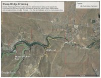
The parcel is currently permitted for a 275 house subdivision, which would dramatically change the wild and scenic character of Virgin (current population ~633), not to mention impacting recreational access. The section of the impacted trails is one of the most dramatic, as it hugs the edge of the river rim. The impacted trails are lower JEM, and Hurricane Rim near the JEM junction. If you want to help out, please spread the word or contribute to the conservation fund. Even a few dollars helps. We're hoping to start doing active outreach at the lower JEM trailhead over the holidays.

For more information see the organization website or Facebook page.
jem (1).jpg
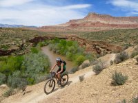
photo courtesy of Janel C

sheepBrTrails.png
 
We saw a small sign with this info at the lower JEM TH last weekend. To say that this land is worth protecting is a huge understatement. We donated that evening while eating pizza at River Rock Roasting Co. Good idea to share this here. Thanks @fossana !
 
Thanks for contributing, @wabenho! It didn't sound like the local MTB org (who built the Hurricane Rim trails) was aware based on comments on their FB page, so trying to spread the word. I ditched FB and haven't ridden the trails since late spring, so was late to learn myself.
 
If any of you have enjoyed mountain biking, hiking, or wildlife watching on the Hurricane Rim trails in Virgin UT along the Zion corridor, local conservation organization, Virgin River Land Preservation Association, is pairing with Nature Conservancy to raise money to purchase a 419 acre private land parcel along the Virgin River to protect it from development. For context, Virgin River Land Preservation Association was responsible for acquiring the land for Confluence Park near La Verkin.

The parcel is currently permitted for a 275 house subdivision, which would dramatically change the wild and scenic character of Virgin (current population ~633), not to mention impacting recreational access. The section of the impacted trails is one of the most dramatic, as it hugs the edge of the river rim. The impacted trails are lower JEM, and Hurricane Rim near the JEM junction. If you want to help out, please spread the word or contribute to the conservation fund. Even a few dollars helps. We're hoping to start doing active outreach at the lower JEM trailhead over the holidays.

For more information see the organization website or Facebook page.
View attachment 71668
photo courtesy of Janel C

View attachment 71672
Will you guys be there Thursday? I plan on camping out there Wed night and riding JEM Thursday morning before stuffing my face in St. George. I love this trail and this area of riding.

I read your post again. I will donate online.


Sent from my SM-G935V using Tapatalk
 
I live ~20 min from the trailhead, so I would ride with you if it's not raining significantly (50% chance in the morning, but not much precip expected). I try to be a good trail citizen and not ride when it's wet. :)

Thanks for contributing too!
 
I live ~20 min from the trailhead, so I would ride with you if it's not raining significantly (50% chance in the morning, but not much precip expected). I try to be a good trail citizen and not ride when it's wet. :)

Thanks for contributing too!
I would never ride JEM in the rain or after while it is still wet. I promise. I too am a good trail citizen and advocate of mountain biking and am well aware of the weather. If it is rideable I will, if not there are trails that are better to ride after they have received a little bit of precipitation like Church Rocks.

I use to live in St. George and appreciate all the hard work DMBTA has put in and those that did trail work before they existed. I also don't need a muddy bike in the back of my car. Camping out there because it will be easy and free as I roll through to Nevada.


Sent from my SM-G935V using Tapatalk
 
Similar threads
Thread starter Title Forum Replies Date
SteveR Sheep River Road Ride on May Day Everything Else 2
XID_AZ Kanab Creek Wilderness - Sowats Canyon - Mountain Sheep Spring Trip Planning 6
Dave High Uinta sheep grazing EIS General Discussion 2
J Paria-Hackberry 10 Days backpacking April 23-May 2, 2017 Asay, Paria, Sheep, BVG, Willis Part 2 Backpacking 0
Nick Forbidding & Mountain Sheep On The Water 21
Udink Nine Mile Canyon VI: Big, Big Sheep Hiking & Camping 0
Nick Mountain Lion and Bighorn Sheep fall to their deaths General Discussion 1
NateGeesaman Willis Creek to Sheep Creek to Paria River - Sept 2012 Backpacking 22
regehr Maybird Gulch bridge is broken Hiking & Camping 4
Titans CEDAR MESA VISITS: OPEN AGAIN// (Extended bridge closure, west of Blanding, on SR-95) General Discussion 5
J Mamie Creek Natural Bridge General Discussion 1
SKLund Chimayosos, A Bridge, and Ian Barbosa Hiking & Camping 3
D Current Water-Rainbow Bridge North Trail Trip Planning 0
WasatchWill Hiking Chimney Rock & Hickman Bridge Hiking & Camping 2
D Rainbow Bridge North Trail Backpacking 4
Eugene Escalante River Town to Hwy 12 Bridge Backpacking 7
Eugene Rainbow Bridge North Trail (this time the full trail) Backpacking 1
Eugene North Rainbow Bridge Trail Backpacking 7
Eugene Rainbow Bridge - North Trail Trip Planning 6
IntrepidXJ Bear Creek & Bridge of Heaven Hiking & Camping 9
uintahiker Tonto Natural Bridge, AZ Hiking & Camping 2
pixie1339 Hickman Bridge Trail General Discussion 6
John Mckean Boulder mail trail to Hwy 12 bridge question General Discussion 6
BJett Part 3 - Tour de Canyon Country. Lower Escalante Loop Hiking & Camping 0
fiber Lower Grand Gulch Pour-off Trip Planning 9
slieb Lower Muddy Creek in Winter? Trip Planning 7
regehr water in lower muley twist? Trip Planning 0
regehr Lower Horseshoe Canyon and Big Spring Trip Planning 7
J Scrambles in the Lower Colorado River Corridor AZ/NV; Dec. 11-14, 2020 Hiking & Camping 5
Devin Ashby The Lower Gulch - Escalante (Seeking info on the route) Trip Planning 14
RyanP Lower Death Hollow next week (late May/early June), miscellaneous questions Trip Planning 16
Stephanie B Sixteen Room Ruin and Lower Butler Wash Hiking & Camping 15
Boognish Lower Death Hollow Narrows April 2018 Backpacking 17
T Dark canyon - lower blm portion with pack goats?? Canyoneering 2
pstm13 Texas Pass Cirque of Towers Lower Wind River Range August 2018 Trip Planning 7
Ross West Canyon quicksand (a/one want to go lower West/Face/Labyrinth August? Trip Planning 3
Strawsome Lower Death Hollow at it's finest Backpacking 3
DiscGo Lower Watermaiden [Video] Hiking & Camping 5
RyanP Lower Death Hollow, mid-April Trip Planning 8
Outdoors24 Overnight in Lower Spring Canyon Backpacking 5
Ravialdo Lower Muley Twist water situation? Trip Planning 13
Udink Lower Horseshoe Canyon Hiking & Camping 0
Kullaberg63 Lower Dirty Devil Backpacking 7
Jackson Lower Red Castle Lake Backpacking 4
scatman Lower and Midway Geyser Basins plus Buffalo Meadows - Yellowstone National Park - June 26, 2016 Backpacking 5
BJett Lower Escalante Trifecta - Davis Gulch to Fiftymile Creek Backpacking 8
BJett Lower Escalante Trifecta - Willow Gulch to Davis Gulch Backpacking 14
mattvogt7 Lower Escalante Packraft Loop Backpacking 12
Jackson Lower Spring Canyon in Winter Backpacking 14
Nick Floating lower Cataract into Glen Canyon Trip Planning 2

Similar threads

Back
Top