Laura V.
I'm not lost. I'm on an adventure.
- Joined
- Feb 15, 2021
- Messages
- 48
June 2021 - Mineral King, SEKI: Franklin Pass > Black Rock Pass > Timber Gap
(elevation gain 12,140 feet, approximately 50 miles)
In June I talked my friend Marie into a five-day backpacking trip in the Mineral King area of Sequoia Kings Canyon NP. The route would take us on trail to Franklin Lakes, then up and over Franklin Pass to Little Claire Lake, past Big Five Lakes and Little Five Lakes, up and over Black Rock Pass to Cliff Creek, and finally up through Timber Gap and back to the trailhead. Pristine, alpine lakes, stunning High Sierra views, wildflowers, and perfect weather were in store.

Zero Day:
We drove from the San Francisco Bay Area and arrived at Cold Springs Campground, located on Mineral King Road* about a mile or so from the trailhead, at about 1 p.m. Cold Springs is reservable online and makes an enjoyable and convenient base camp for getting acclimated to the altitude if you live at sea level like me. The campground was not full, but I would recommend making a reservation first since it's a long way to anyplace where you can legally camp if you arrive without a reservation and everything is booked. The Franklin Lakes-Timber Gap route begins at around 7,500 feet and ascends over 11,000 foot passes, so a day to catch our breath was in order. We picked up our permit at the nearby Mineral King Ranger Station and spent the rest of the afternoon in camp enjoying the creek and relaxing. Because RV's are not allowed here, the campground is very quiet compared to most established campgrounds.
*Mineral King Road, for whatever reason, has a reputation for being one of California's "scariest" roads. It is narrow and winding with a few steep drops that you wouldn't want to roll your vehicle down, but it isn't the white knuckle ride that people make it out to be if you read the descriptions online. For anyone at all experienced driving mountain roads, it is very straightforward. It is NOT suitable for RV's and the like which is probably how it gets its reputation. For passenger vehicles, the road is wide enough in most areas for oncoming traffic to easily pass, and there are plenty of places to pull over and wait when passing isn't possible.
Day One: Trailhead to Franklin Lakes (elevation gain 2,698 feet, 6.3 miles)
We set out hiking from the trailhead towards Farewell Gap and Franklin Lakes. There is a small parking lot at the end of Mineral King Road which fills up quickly on weekends (it is CA, you know), so plan to arrive early. Rangers recommend tarping your vehicle so that the marmots don't investigate (and attempt to eat) your brake lines while you are out hiking. Each time that I've been here, the marmots have not been shy, so it's probably 15 minutes well spent to do so. From the parking lot, continue walking up the fire road for five minutes to the closed access gate. The gate marks the beginning of this route. Continue walking past the gate up the fire road which soon becomes the Farewell Canyon trail.

The hike to Franklin Lakes begins with a pretty stroll through Aspen groves and meadow with a nice view of Farewell Gap ahead. Soon, a series of long switchbacks begins leading to the trail junction with Franklin Lakes or to Farewell Gap beyond. Due to the drought this year, there was no snow and the water crossings for this entire route were all very mellow. There was still plenty of water in June resulting in beautiful cascading waterfalls and inviting swimming holes (sorry, my photos of them are mostly oriented as portraits, and I can't figure out how to upload them here in the correct orientation for viewing...).

Looking up at Farewell Gap. The trail junction to Franklin Lakes ultimately takes you left of the Gap.


Campsites at Lower Franklin Lake are mostly on the north side of the lake though a few very small sites do exist on the south side as well. During our trip, there were four other small groups camped at the lake - a little crowded for my taste - however, there were enough nooks and crannies for everyone to disappear into.
We set up our tents and had a spectacular view of the lake and valley below as we fixed and ate dinner. It was 20 degrees F at Cold Springs the night before, so we were ready for another cold night, but it never dropped below 40 degrees F for the rest of the trip.


Day Two: Franklin Lakes to Little Claire Lake
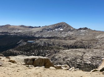
We were up and on trail early, ready to start the climb over Franklin Pass (elevation gain 1,279 feet). Still feeling the effects of elevation, we took our time and enjoyed the beautiful views of the upper Franklin Lakes as we worked our way along the numerous switchbacks to the top of the pass. From here, standing on the Great Western Divide, we were rewarded with a spectacular panoramic view.


This was pretty much the extent of the snow. A very sad sight so early in June.

Interesting rock fins at the summit of Franklin Pass (elevation 11,710 feet)


While descending from the pass, we stopped for a quick break but were soon back on our feet. In spite of the clear sky above, a thunderstorm was approaching out of view from the south. Three unexpected thunderclaps put an extra spring in our step.
We were rewarded later when we came to Forester Lake and had it all to ourselves. We took a long and delightful break here to swim, have lunch, and take in the view. In hindsight, I wish we had camped here. The lake was beautiful, and everyone else who had camped at Franklin Lakes the night before pushed on, unbeknownst to us, to Little Claire Lake which was also our destination for the night. Most people are hoping to make miles to Big Five Lakes the next day, so it seems like everyone speeds by Forester Lake in their hurry. It is their loss and your gain if you choose to stay here, I think.

The hike to Little Claire Lake from Forester Lake is less than two miles through the forest. The views here aren't spectacular, but that just allows you to keep your eyes on the trail. As you descend into the Little Claire Lake Basin, the trail becomes faint as people have been forced off of it to skirt numerous blow downs.
Arriving at Little Claire Lake, there are many excellent possible camps. If you look around, you might be rewarded with especially nice views (hint hint). There were lots of blow downs around the lake and many other trees that were soon to follow. We moved the tents around a couple of times after closer inspections of the trees around us. Little Claire Lake is beautiful. It's popular though because it's the last good place to camp for a while. The trail drops away from the lake on a steep descent for a few miles along Soda Creek. Luckily, like the night before, all of us who were gathered around the lake were able to tuck into little alcoves preserving the wilderness feel of the place.
After another swim and plenty of time to sit with that view, it was time for a quick dinner before retreating to my tent to escape the mosquitoes and read.


Day Three: Little Claire Lake to (Lower) Big Five Lakes
Once you leave Little Claire Lake, the trail immediately begins its descent of 1,000 feet into a canyon adjacent to Soda Creek. Soda Creek is stunningly beautiful as it plunges over cascading waterfalls and slides into deep, inviting pools. The real pity is that you can only catch fleeting glimpses of it from the trail. Heading counter-clockwise along the trail as we did, most of the view is behind you. We stopped frequently to turn around and admire the creek. Eventually, the trail levels out and cuts closer to the water. We took this opportunity to find a nice pool where we stopped to swim and take a long lunch break.

Approximately 3.5 miles after leaving Little Claire Lake, we arrived at a major trail junction. Continuing to the right leads to the Big Arroyo and the High Sierra Trail. Turning left leads to Lost Canyon and Big Five Lakes. We turned left and began a hot slog in the afternoon sun up 1,000 feet to Lower Lost Canyon. On the plus side, the trail paralleled Lost Canyon Creek with spectacular views of long waterfalls into the canyon below. Initially, we had planned to camp at the junction with Lost Canyon so that we could explore Lost Canyon as a day hike. Many people choose to stay here and then hike out via Lost Canyon and Sawtooth Pass the next day. In the end, we only stopped for water and a few photos deciding to continue on instead to Lower Big Five Lakes about 2.5 miles ahead.
The hike through the forest from Lost Canyon to the first of the Big Five Lakes is probably the least spectacular in terms of view along the entire route. Views of the Kaweahs occasionally reward you, but for the most part this is a monotonous walk through the woods.
When we descended into the first Big Five Lakes basin, we were tired, a little grumpy (speaking for myself), and ready for camp. Most people continue on for another half mile or so to a spur trail which leads to the other lakes, but this would have required an 800 foot ascent out of the basin. We opted instead to camp at this first lake. It was extremely pretty, and we had the entire lake to ourselves. As a bonus, there was a large rock outcropping with spectacular views of the lake which made the perfect picnic spot for dinner and breakfast the next morning.
The mosquitoes were bad here, so we retreated into our tents early to rest up for "the big day" ahead: tackling Black Rock Pass.


Day Four: (Lower) Big Five Lakes to Cliff Creek (elevation gain 1,800 feet; elevation loss 4,480 feet)
On day four, we were up extra early in anticipation of Black Rock Pass. We took our time enjoying breakfast and our view of the lake before packing up and setting out on trail by 7:30. Right away, the trail began a steep climb out of the basin. We encountered hikers coming up from the spur trail to the upper lakes and learned that the mosquitoes there had been quite horrendous. It sounds like we had a better experience at the lower lake.
Before long, we began a descent into the Little Five Lakes area. Still early, we opted to stop for a 30 minute break to rest before beginning the hike up Black Rock Pass. This turned out to be my favorite part of the entire route. Each new gain afforded stunning views of the High Sierra landscape. We had a bluebird sky and the trail all to ourselves.


The hike down the west side of Black Rock Pass was an unending ribbon of switchbacks descending 4,480 feet from the summit to our camp for the night at Cliff Creek. A mile below the summit, I caught the toe of my boot and tripped, breaking one of my trekking poles in the process. I have crunchy knees like most hikers probably, so the last 2,500 feet or so were a bit unpleasant with them screaming in protest the whole way.
On the descent, we encountered three small groups of other hikers who each, without prompting, warned us not to, under any circumstances, camp at Pinto Lake. Each messenger had an earnestness and intensity in his eyes which convinced us that the suffering brought forth by the Pinto Lake mosquitoes was too great to bear. Originally, our plan was to camp at Pinto Lake, but hearing this, we continued on to Cliff Creek a few miles farther ahead.
Cliff Creek was a beautiful place to camp and blessedly free of mosquitoes.
Day Five: Cliff Creek to Timber Gap Trailhead
The last day offered up a beautiful hike to Timber Gap with pretty views of more cascading creeks, lush vegetation, beautiful wildflowers, meadows, and dense forest. I spotted several game cameras on the trees and figured that the NPS must be monitoring bear activity in the area. There was heavy bear sign along the trail and plenty for them to eat. Sure enough, about 2.5 miles into our hike out, I heard more than saw a large bear tumble out of a tree and go careening down canyon. This was really our only wildlife sighting along the route with the exception of two deer and a bunch of mischievous marmots at the trailhead.
The hike up to Timber Gap was one of the prettiest parts of the whole hike in terms of vegetation, but unfortunately, my pictures are all once again oriented the wrong way. The diversity of flora and color was really stunning though.
Once at the summit of Timber Gap, we took one more break to enjoy the quiet before heading down the two miles or so to the trailhead. On the way out, we stopped at Silver City Mountain Resort a couple of miles down the road where, for $6 each, we were able to buy a hot shower and a Coke - just what we needed before the drive home.
(elevation gain 12,140 feet, approximately 50 miles)
In June I talked my friend Marie into a five-day backpacking trip in the Mineral King area of Sequoia Kings Canyon NP. The route would take us on trail to Franklin Lakes, then up and over Franklin Pass to Little Claire Lake, past Big Five Lakes and Little Five Lakes, up and over Black Rock Pass to Cliff Creek, and finally up through Timber Gap and back to the trailhead. Pristine, alpine lakes, stunning High Sierra views, wildflowers, and perfect weather were in store.
Zero Day:
We drove from the San Francisco Bay Area and arrived at Cold Springs Campground, located on Mineral King Road* about a mile or so from the trailhead, at about 1 p.m. Cold Springs is reservable online and makes an enjoyable and convenient base camp for getting acclimated to the altitude if you live at sea level like me. The campground was not full, but I would recommend making a reservation first since it's a long way to anyplace where you can legally camp if you arrive without a reservation and everything is booked. The Franklin Lakes-Timber Gap route begins at around 7,500 feet and ascends over 11,000 foot passes, so a day to catch our breath was in order. We picked up our permit at the nearby Mineral King Ranger Station and spent the rest of the afternoon in camp enjoying the creek and relaxing. Because RV's are not allowed here, the campground is very quiet compared to most established campgrounds.
*Mineral King Road, for whatever reason, has a reputation for being one of California's "scariest" roads. It is narrow and winding with a few steep drops that you wouldn't want to roll your vehicle down, but it isn't the white knuckle ride that people make it out to be if you read the descriptions online. For anyone at all experienced driving mountain roads, it is very straightforward. It is NOT suitable for RV's and the like which is probably how it gets its reputation. For passenger vehicles, the road is wide enough in most areas for oncoming traffic to easily pass, and there are plenty of places to pull over and wait when passing isn't possible.
Day One: Trailhead to Franklin Lakes (elevation gain 2,698 feet, 6.3 miles)
We set out hiking from the trailhead towards Farewell Gap and Franklin Lakes. There is a small parking lot at the end of Mineral King Road which fills up quickly on weekends (it is CA, you know), so plan to arrive early. Rangers recommend tarping your vehicle so that the marmots don't investigate (and attempt to eat) your brake lines while you are out hiking. Each time that I've been here, the marmots have not been shy, so it's probably 15 minutes well spent to do so. From the parking lot, continue walking up the fire road for five minutes to the closed access gate. The gate marks the beginning of this route. Continue walking past the gate up the fire road which soon becomes the Farewell Canyon trail.
The hike to Franklin Lakes begins with a pretty stroll through Aspen groves and meadow with a nice view of Farewell Gap ahead. Soon, a series of long switchbacks begins leading to the trail junction with Franklin Lakes or to Farewell Gap beyond. Due to the drought this year, there was no snow and the water crossings for this entire route were all very mellow. There was still plenty of water in June resulting in beautiful cascading waterfalls and inviting swimming holes (sorry, my photos of them are mostly oriented as portraits, and I can't figure out how to upload them here in the correct orientation for viewing...).
Looking up at Farewell Gap. The trail junction to Franklin Lakes ultimately takes you left of the Gap.
Campsites at Lower Franklin Lake are mostly on the north side of the lake though a few very small sites do exist on the south side as well. During our trip, there were four other small groups camped at the lake - a little crowded for my taste - however, there were enough nooks and crannies for everyone to disappear into.
We set up our tents and had a spectacular view of the lake and valley below as we fixed and ate dinner. It was 20 degrees F at Cold Springs the night before, so we were ready for another cold night, but it never dropped below 40 degrees F for the rest of the trip.
Day Two: Franklin Lakes to Little Claire Lake
We were up and on trail early, ready to start the climb over Franklin Pass (elevation gain 1,279 feet). Still feeling the effects of elevation, we took our time and enjoyed the beautiful views of the upper Franklin Lakes as we worked our way along the numerous switchbacks to the top of the pass. From here, standing on the Great Western Divide, we were rewarded with a spectacular panoramic view.
This was pretty much the extent of the snow. A very sad sight so early in June.
Interesting rock fins at the summit of Franklin Pass (elevation 11,710 feet)
While descending from the pass, we stopped for a quick break but were soon back on our feet. In spite of the clear sky above, a thunderstorm was approaching out of view from the south. Three unexpected thunderclaps put an extra spring in our step.
We were rewarded later when we came to Forester Lake and had it all to ourselves. We took a long and delightful break here to swim, have lunch, and take in the view. In hindsight, I wish we had camped here. The lake was beautiful, and everyone else who had camped at Franklin Lakes the night before pushed on, unbeknownst to us, to Little Claire Lake which was also our destination for the night. Most people are hoping to make miles to Big Five Lakes the next day, so it seems like everyone speeds by Forester Lake in their hurry. It is their loss and your gain if you choose to stay here, I think.
The hike to Little Claire Lake from Forester Lake is less than two miles through the forest. The views here aren't spectacular, but that just allows you to keep your eyes on the trail. As you descend into the Little Claire Lake Basin, the trail becomes faint as people have been forced off of it to skirt numerous blow downs.
Arriving at Little Claire Lake, there are many excellent possible camps. If you look around, you might be rewarded with especially nice views (hint hint). There were lots of blow downs around the lake and many other trees that were soon to follow. We moved the tents around a couple of times after closer inspections of the trees around us. Little Claire Lake is beautiful. It's popular though because it's the last good place to camp for a while. The trail drops away from the lake on a steep descent for a few miles along Soda Creek. Luckily, like the night before, all of us who were gathered around the lake were able to tuck into little alcoves preserving the wilderness feel of the place.
After another swim and plenty of time to sit with that view, it was time for a quick dinner before retreating to my tent to escape the mosquitoes and read.
Day Three: Little Claire Lake to (Lower) Big Five Lakes
Once you leave Little Claire Lake, the trail immediately begins its descent of 1,000 feet into a canyon adjacent to Soda Creek. Soda Creek is stunningly beautiful as it plunges over cascading waterfalls and slides into deep, inviting pools. The real pity is that you can only catch fleeting glimpses of it from the trail. Heading counter-clockwise along the trail as we did, most of the view is behind you. We stopped frequently to turn around and admire the creek. Eventually, the trail levels out and cuts closer to the water. We took this opportunity to find a nice pool where we stopped to swim and take a long lunch break.
Approximately 3.5 miles after leaving Little Claire Lake, we arrived at a major trail junction. Continuing to the right leads to the Big Arroyo and the High Sierra Trail. Turning left leads to Lost Canyon and Big Five Lakes. We turned left and began a hot slog in the afternoon sun up 1,000 feet to Lower Lost Canyon. On the plus side, the trail paralleled Lost Canyon Creek with spectacular views of long waterfalls into the canyon below. Initially, we had planned to camp at the junction with Lost Canyon so that we could explore Lost Canyon as a day hike. Many people choose to stay here and then hike out via Lost Canyon and Sawtooth Pass the next day. In the end, we only stopped for water and a few photos deciding to continue on instead to Lower Big Five Lakes about 2.5 miles ahead.
The hike through the forest from Lost Canyon to the first of the Big Five Lakes is probably the least spectacular in terms of view along the entire route. Views of the Kaweahs occasionally reward you, but for the most part this is a monotonous walk through the woods.
When we descended into the first Big Five Lakes basin, we were tired, a little grumpy (speaking for myself), and ready for camp. Most people continue on for another half mile or so to a spur trail which leads to the other lakes, but this would have required an 800 foot ascent out of the basin. We opted instead to camp at this first lake. It was extremely pretty, and we had the entire lake to ourselves. As a bonus, there was a large rock outcropping with spectacular views of the lake which made the perfect picnic spot for dinner and breakfast the next morning.
The mosquitoes were bad here, so we retreated into our tents early to rest up for "the big day" ahead: tackling Black Rock Pass.
Day Four: (Lower) Big Five Lakes to Cliff Creek (elevation gain 1,800 feet; elevation loss 4,480 feet)
On day four, we were up extra early in anticipation of Black Rock Pass. We took our time enjoying breakfast and our view of the lake before packing up and setting out on trail by 7:30. Right away, the trail began a steep climb out of the basin. We encountered hikers coming up from the spur trail to the upper lakes and learned that the mosquitoes there had been quite horrendous. It sounds like we had a better experience at the lower lake.
Before long, we began a descent into the Little Five Lakes area. Still early, we opted to stop for a 30 minute break to rest before beginning the hike up Black Rock Pass. This turned out to be my favorite part of the entire route. Each new gain afforded stunning views of the High Sierra landscape. We had a bluebird sky and the trail all to ourselves.
The hike down the west side of Black Rock Pass was an unending ribbon of switchbacks descending 4,480 feet from the summit to our camp for the night at Cliff Creek. A mile below the summit, I caught the toe of my boot and tripped, breaking one of my trekking poles in the process. I have crunchy knees like most hikers probably, so the last 2,500 feet or so were a bit unpleasant with them screaming in protest the whole way.
On the descent, we encountered three small groups of other hikers who each, without prompting, warned us not to, under any circumstances, camp at Pinto Lake. Each messenger had an earnestness and intensity in his eyes which convinced us that the suffering brought forth by the Pinto Lake mosquitoes was too great to bear. Originally, our plan was to camp at Pinto Lake, but hearing this, we continued on to Cliff Creek a few miles farther ahead.
Cliff Creek was a beautiful place to camp and blessedly free of mosquitoes.
Day Five: Cliff Creek to Timber Gap Trailhead
The last day offered up a beautiful hike to Timber Gap with pretty views of more cascading creeks, lush vegetation, beautiful wildflowers, meadows, and dense forest. I spotted several game cameras on the trees and figured that the NPS must be monitoring bear activity in the area. There was heavy bear sign along the trail and plenty for them to eat. Sure enough, about 2.5 miles into our hike out, I heard more than saw a large bear tumble out of a tree and go careening down canyon. This was really our only wildlife sighting along the route with the exception of two deer and a bunch of mischievous marmots at the trailhead.
The hike up to Timber Gap was one of the prettiest parts of the whole hike in terms of vegetation, but unfortunately, my pictures are all once again oriented the wrong way. The diversity of flora and color was really stunning though.
Once at the summit of Timber Gap, we took one more break to enjoy the quiet before heading down the two miles or so to the trailhead. On the way out, we stopped at Silver City Mountain Resort a couple of miles down the road where, for $6 each, we were able to buy a hot shower and a Coke - just what we needed before the drive home.
Attachments
Last edited: