- Joined
- Aug 23, 2016
- Messages
- 145
I think it was when I was in high school I read an article about kayaking in the Gulf of California. I told myself I would do that someday. After retiring, Stacy and I finally had time. I signed us up for a kayak trip out of Loreto, Baja California Sur, and started looking into other things to do while in Baja. I came up with whale watching on both the Pacific and Gulf of California sides and seeing rock art up in the central mountains. And just driving around seeing what else was there. I had seen some of @Fatboy 's trip reports and contacted him for advice for driving in Baja. Paraphrased here, he told me to bring a full-size spare, a 12 volt air compressor, and my common sense. Perfect advice. We took one week to drive from Georgia to Baja, spent 3 weeks in Baja and another week to get home. On the way to and from Mexico we visited friends and family along the way so the drive never seemed excessive. We were in Baja from mid-Feb through early March.
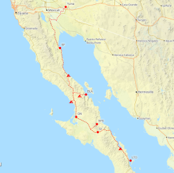
Our route through Baja. SF=San Felipe, BLA=Bahia Los Angeles, GN=Guerrero Negro, SFS=San Francisco de la Sierra, SI=San Ignacio, LTO=Loreto. Some camping locations also shown
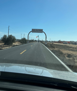
There were lots of welcome signs over the highway. This is typical Baja main highway. Narrow, with no shoulder and a nasty dropoff at the edge of the pavement.
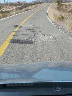
Some of the drive was white-knuckle pothole slalom
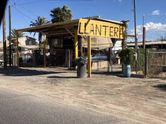
Maybe because of the road conditions there were llanteras (tire repair shops) everywhere
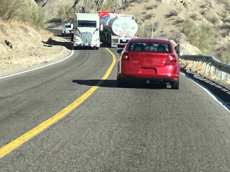
Last driving picture. This one gives a good idea of how narrow the roads are. Generally very little traffic but the trucks went pretty slow through the windy or hilly parts and caused a little bunching up now and then.
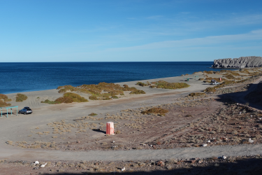
We spent our first night in Baja here at a beach camp on the Gulf of California. Typical facilities—some shade structures and porta-potties.
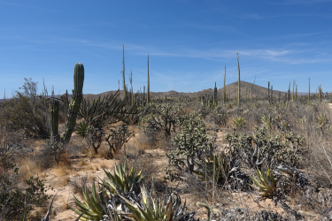
As we made our way south the vegetation became more and more strange (to our eyes)

A lot of the plants here grow only or almost only in Baja. This is cirio or boojum tree
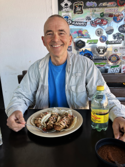
Our first fish tacos (Bahia de Los Angeles). Looks like I am eating bratwurst but those are deep-fried pieces of fish in the (super fresh) tortillas. The food on this trip was unbelievably good.
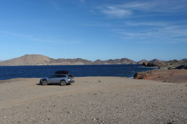
We found a cool camp spot on Bahia de Los Angeles but it was REALLY windy. We headed out into the desert for the night hoping it would be less windy away from the coast.
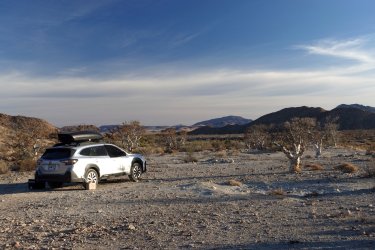
Much less windy inland. The strange trees are elephant trees or torote blanco, another plant endemic to Baja
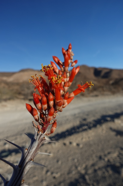
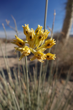
A couple flowers. The red one is ocotillo, I think. Don't know the other one.
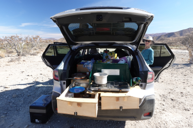
Our Subaru Outback camper. I took out the back seat and put in a platform. The kitchen fits in one of the drawers and they make nice workspaces when slid out. After we stow the kitchen we can sleep in the back
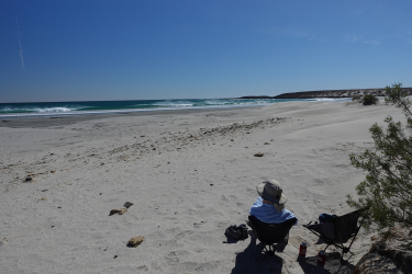
Next night we camped on the Pacific side. It was windy again but we were able to get in amongst the dunes and vegetation and stay out of it pretty well.
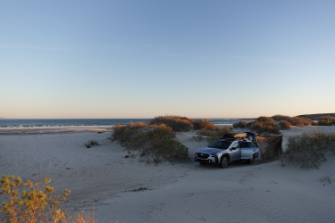
Put up a windbreak for the wind that made it through the dunes
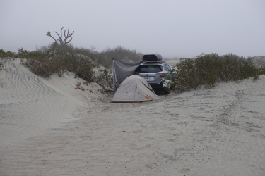
We can sleep in the back of the Subaru but we also brought a tent. This seemed like a great place for the tent but thick fog rolled in over night and the tent ended up soaking wet and covered in sand.
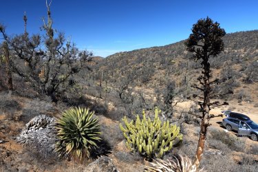
In the morning we headed for Guerrero Negro but took a detour out into the desert to look at the plant life. Century plants here, pitaya agria cactus and another variety of elephant tree
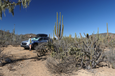
The big cacti are cardon (similar to saguaro but a different genera), pitaya agria, cholla, boojum trees, some barely visible datilillo yucca and various things I don’t know.
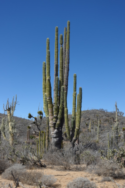
More Baja plant life.
View attachment 140591
Some places were practically cardon forests
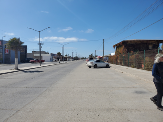
The main street of Guerrero Negro. I signed us up for a whale watching trip in Laguna Ojo de Liebre, near Guerrero Negro—one of the places gray whales stop on their migration. I thought it would be best to spend the night here before and after the trip even though it was only a half day trip. When I first saw GN I thought that might have been a mistake. The town is in the middle of a dead-flat barren windswept plain. You could literally see clouds of dust blowing across the main street from the side streets. The whole place looked run down and sort of depressing. But wow, was I wrong. We loved it here. Everyone was super friendly and the food was great. There was also a very nice whale museum. Just a great vibe all around. We stopped here again on the way back north to get lunch.
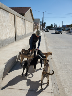
Even the dogs were friendly!

Our hotel and headquarters for the whale watching outfit. I should have taken a picture of the very sad looking van that took us to the start of the whales trip. It was in pretty bad shape. We just sort of rolled to a stop a couple of times on the way (in the middle of the salt flats) but our driver managed to get it started again. Our guide said we just need to have faith in our driver, Jesus.
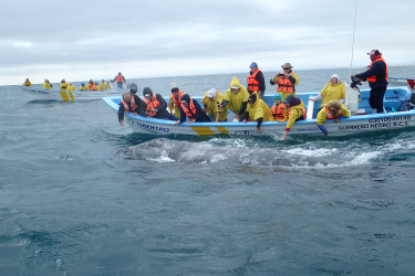
And the whales were friendly too! They came right up to the boats and let you touch them. And just so you know, all of the people in that boat can lean over the same side and the boat does not capsize.
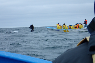
Classic whale picture. These were gray whales
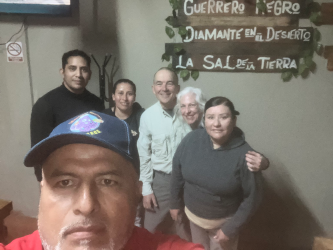
We had dinner one evening at a little restaurant called Mariscos Guerrero. I think it was the best meal I ever had. We were the only ones in there and they treated us like we were royalty or something. Stacy asked if we could get a photo with the restaurant staff. I think it was the owner taking the photo. That’s the waiter and kitchen staff with Stacy and me. And the sign is right—a diamond in the desert. The salt part refers to the main industry of the town and why the town is there in the first place. It’s the world’s largest open-sky salt “mine”. Not a mine exactly as the salt is precipitated in a series of evaporation lagoons.
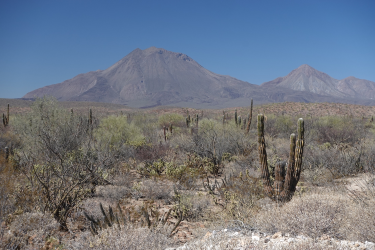
Back on the road. This Volcan Tres Virgenes
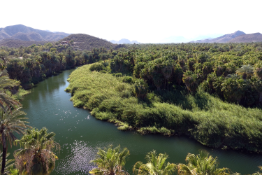
We stopped off in the town of Mulege to see the spanish mission there. The town is an honest-to-god desert oasis with a large groundwater-fed lagoon

Mulege Mission. Founded in 1705. I think the existing building was constructed later but still in the 1700s
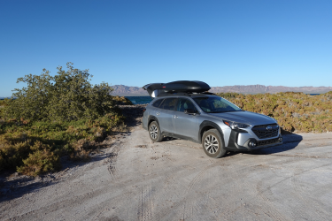
We camped on the beach again on the shore of Bahia Conception
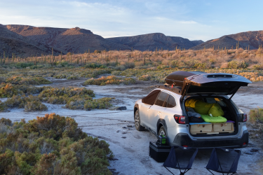
Here you can see the sleeping setup in the Subaru. The only problem with it is you cannot sit up. So getting dressed and undressed requires a certain amount of flexibility
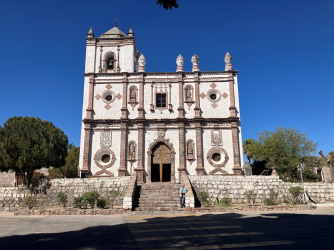
The Spanish mission in San Ignacio, constructed in 1786. We stopped in San Ignacio to check on our reservations for the rock art trip we would take after kayaking

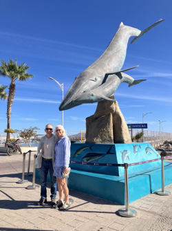
Loreto was nice. Definitely a more typical tourist town but that was ok. It is known as a place to see blue whales
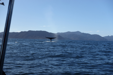
We went out on another whale watching trip and saw some blue whales. They come up into the Gulf of California in Jan and Feb to eat the krill that is abundant there at that time. Unlike the gray whales that seem to be curious about the whale-watching boats, the blue whales are not interested. To avoid harassing the whales there are rules about how the boats approach the whales and how close they can get. The whale guides seem to take it all very seriously.
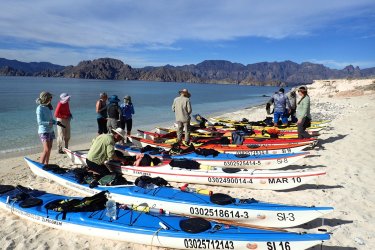
The main reason we went to Baja was to do a kayak trip in the Gulf of California. It was a 6 day guided trip out to islands near Loreto. There were nine participants and two guides. We had never done a guided trip like this and were a little apprehensive. Turned out to be a great trip all around. Good food, good guides and other clients, wildlife, scenery.
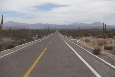
After the kayak trip we took a trip to see some rock art in the Sierra San Francisco. This is the road leading up there from the main highway (looking east). The road had recently been redone and was one of the best roads of the whole trip, even though it led to the middle of nowhere. I plan to make a separate trip report just for the rock art trip. (EDIT: Link here to rock art trip report)

We met our guide here at San Francisco de la Sierra. The green building is a small store, the school playground is on the right
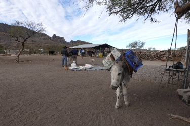
We started at the guide's home, The whole family helped load up. The rock art is located in deep remote canyons and you can only go there with a certified guide. We and the guide (and an apprentice guide) rode mules, our gear was carried by burros. We really got to practice our Spanish on this part of the trip. Our guides spoke no English
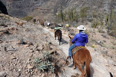
It was a three-day trip. One day to get into the canyon, one day to see the rock art, and one day to get back out. The terrain here is similar to some of what @Fatboy hiked through in his recent Baja trips. Very steep and rocky with extremely thorny plants. We were happy to be on a trail with sure-footed mules led by knowledgeable guides
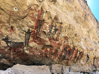
This is one of the largest and best-preserved sites, Cueva Pintada. Many of the Baja paintings are about 7000 years old and the oldest are 11000 yrs. Many of them are huge. For scale, the human figures in the bottom center of this photo are about life-sized. @Fatboy quoted from a book about Baja’s Camino Real, The King’s Highway in Baja California, by Harry W. Crosby. Besides exploring the Camino, Crosby also led many exploratory trips to find, photograph and catalog Baja rock art. He published the definitive Baja rock art volume, Cave Paintings Of Baja California: Discovering the Great Murals of an Unknown People.
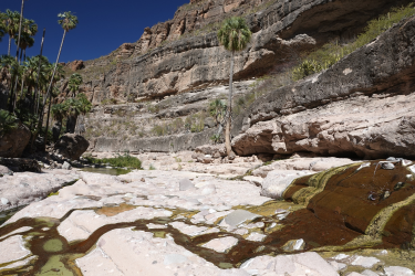
The Mexican government has worked hard to preserve and protect the rock art. Part way up the canyon wall you can see the platform and railing at Cueva Pintada. You can also get an idea of how large the site is. All of the sites are near water sources. At the bottom of this canyon there are several springs. On the right you can see where someone has put a pipe into a spring to make it easy to fill water bottles. It is quite strange to see pools of water and palm trees in such a dry desert.

On the way home we camped again at our first campsite on the Gulf of California. After this we headed north and stopped in San Felipe to stock up on all the Mexican food items we would be allowed to take across the border like sauces and canned fish. And our last batch of fresh tortillas. We crossed again at San Luis Rio Colorado into Arizona south of Yuma. The US customs person seemed most concerned about agricultural-type products and asked us specifically if we had any fresh fruits, vegetables, meat, plants or soil. We did not. After checking our passports they waved us on through. We visited more family and friends on the way across to Georgia and before we knew it we were back home planning our next Baja trip!

Our route through Baja. SF=San Felipe, BLA=Bahia Los Angeles, GN=Guerrero Negro, SFS=San Francisco de la Sierra, SI=San Ignacio, LTO=Loreto. Some camping locations also shown

There were lots of welcome signs over the highway. This is typical Baja main highway. Narrow, with no shoulder and a nasty dropoff at the edge of the pavement.

Some of the drive was white-knuckle pothole slalom

Maybe because of the road conditions there were llanteras (tire repair shops) everywhere

Last driving picture. This one gives a good idea of how narrow the roads are. Generally very little traffic but the trucks went pretty slow through the windy or hilly parts and caused a little bunching up now and then.

We spent our first night in Baja here at a beach camp on the Gulf of California. Typical facilities—some shade structures and porta-potties.

As we made our way south the vegetation became more and more strange (to our eyes)

A lot of the plants here grow only or almost only in Baja. This is cirio or boojum tree

Our first fish tacos (Bahia de Los Angeles). Looks like I am eating bratwurst but those are deep-fried pieces of fish in the (super fresh) tortillas. The food on this trip was unbelievably good.

We found a cool camp spot on Bahia de Los Angeles but it was REALLY windy. We headed out into the desert for the night hoping it would be less windy away from the coast.

Much less windy inland. The strange trees are elephant trees or torote blanco, another plant endemic to Baja


A couple flowers. The red one is ocotillo, I think. Don't know the other one.

Our Subaru Outback camper. I took out the back seat and put in a platform. The kitchen fits in one of the drawers and they make nice workspaces when slid out. After we stow the kitchen we can sleep in the back

Next night we camped on the Pacific side. It was windy again but we were able to get in amongst the dunes and vegetation and stay out of it pretty well.

Put up a windbreak for the wind that made it through the dunes

We can sleep in the back of the Subaru but we also brought a tent. This seemed like a great place for the tent but thick fog rolled in over night and the tent ended up soaking wet and covered in sand.

In the morning we headed for Guerrero Negro but took a detour out into the desert to look at the plant life. Century plants here, pitaya agria cactus and another variety of elephant tree

The big cacti are cardon (similar to saguaro but a different genera), pitaya agria, cholla, boojum trees, some barely visible datilillo yucca and various things I don’t know.

More Baja plant life.
View attachment 140591
Some places were practically cardon forests

The main street of Guerrero Negro. I signed us up for a whale watching trip in Laguna Ojo de Liebre, near Guerrero Negro—one of the places gray whales stop on their migration. I thought it would be best to spend the night here before and after the trip even though it was only a half day trip. When I first saw GN I thought that might have been a mistake. The town is in the middle of a dead-flat barren windswept plain. You could literally see clouds of dust blowing across the main street from the side streets. The whole place looked run down and sort of depressing. But wow, was I wrong. We loved it here. Everyone was super friendly and the food was great. There was also a very nice whale museum. Just a great vibe all around. We stopped here again on the way back north to get lunch.

Even the dogs were friendly!

Our hotel and headquarters for the whale watching outfit. I should have taken a picture of the very sad looking van that took us to the start of the whales trip. It was in pretty bad shape. We just sort of rolled to a stop a couple of times on the way (in the middle of the salt flats) but our driver managed to get it started again. Our guide said we just need to have faith in our driver, Jesus.

And the whales were friendly too! They came right up to the boats and let you touch them. And just so you know, all of the people in that boat can lean over the same side and the boat does not capsize.

Classic whale picture. These were gray whales

We had dinner one evening at a little restaurant called Mariscos Guerrero. I think it was the best meal I ever had. We were the only ones in there and they treated us like we were royalty or something. Stacy asked if we could get a photo with the restaurant staff. I think it was the owner taking the photo. That’s the waiter and kitchen staff with Stacy and me. And the sign is right—a diamond in the desert. The salt part refers to the main industry of the town and why the town is there in the first place. It’s the world’s largest open-sky salt “mine”. Not a mine exactly as the salt is precipitated in a series of evaporation lagoons.

Back on the road. This Volcan Tres Virgenes

We stopped off in the town of Mulege to see the spanish mission there. The town is an honest-to-god desert oasis with a large groundwater-fed lagoon

Mulege Mission. Founded in 1705. I think the existing building was constructed later but still in the 1700s

We camped on the beach again on the shore of Bahia Conception

Here you can see the sleeping setup in the Subaru. The only problem with it is you cannot sit up. So getting dressed and undressed requires a certain amount of flexibility

The Spanish mission in San Ignacio, constructed in 1786. We stopped in San Ignacio to check on our reservations for the rock art trip we would take after kayaking


Loreto was nice. Definitely a more typical tourist town but that was ok. It is known as a place to see blue whales

We went out on another whale watching trip and saw some blue whales. They come up into the Gulf of California in Jan and Feb to eat the krill that is abundant there at that time. Unlike the gray whales that seem to be curious about the whale-watching boats, the blue whales are not interested. To avoid harassing the whales there are rules about how the boats approach the whales and how close they can get. The whale guides seem to take it all very seriously.

The main reason we went to Baja was to do a kayak trip in the Gulf of California. It was a 6 day guided trip out to islands near Loreto. There were nine participants and two guides. We had never done a guided trip like this and were a little apprehensive. Turned out to be a great trip all around. Good food, good guides and other clients, wildlife, scenery.

After the kayak trip we took a trip to see some rock art in the Sierra San Francisco. This is the road leading up there from the main highway (looking east). The road had recently been redone and was one of the best roads of the whole trip, even though it led to the middle of nowhere. I plan to make a separate trip report just for the rock art trip. (EDIT: Link here to rock art trip report)

We met our guide here at San Francisco de la Sierra. The green building is a small store, the school playground is on the right

We started at the guide's home, The whole family helped load up. The rock art is located in deep remote canyons and you can only go there with a certified guide. We and the guide (and an apprentice guide) rode mules, our gear was carried by burros. We really got to practice our Spanish on this part of the trip. Our guides spoke no English

It was a three-day trip. One day to get into the canyon, one day to see the rock art, and one day to get back out. The terrain here is similar to some of what @Fatboy hiked through in his recent Baja trips. Very steep and rocky with extremely thorny plants. We were happy to be on a trail with sure-footed mules led by knowledgeable guides

This is one of the largest and best-preserved sites, Cueva Pintada. Many of the Baja paintings are about 7000 years old and the oldest are 11000 yrs. Many of them are huge. For scale, the human figures in the bottom center of this photo are about life-sized. @Fatboy quoted from a book about Baja’s Camino Real, The King’s Highway in Baja California, by Harry W. Crosby. Besides exploring the Camino, Crosby also led many exploratory trips to find, photograph and catalog Baja rock art. He published the definitive Baja rock art volume, Cave Paintings Of Baja California: Discovering the Great Murals of an Unknown People.

The Mexican government has worked hard to preserve and protect the rock art. Part way up the canyon wall you can see the platform and railing at Cueva Pintada. You can also get an idea of how large the site is. All of the sites are near water sources. At the bottom of this canyon there are several springs. On the right you can see where someone has put a pipe into a spring to make it easy to fill water bottles. It is quite strange to see pools of water and palm trees in such a dry desert.

On the way home we camped again at our first campsite on the Gulf of California. After this we headed north and stopped in San Felipe to stock up on all the Mexican food items we would be allowed to take across the border like sauces and canned fish. And our last batch of fresh tortillas. We crossed again at San Luis Rio Colorado into Arizona south of Yuma. The US customs person seemed most concerned about agricultural-type products and asked us specifically if we had any fresh fruits, vegetables, meat, plants or soil. We did not. After checking our passports they waved us on through. We visited more family and friends on the way across to Georgia and before we knew it we were back home planning our next Baja trip!
Last edited:
