Hey all,
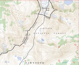
I'm new to this forum but figured I would inquire about a trip I'm currently planning in the Sawtooths this summer (dates still undecided). I'm new to the Sawtooths, but through playing around on Google Earth I found a decent looking off trail route, and I'm curious if anybody is familiar with the area. I'm looking to go from Goat Lake, up the drainage to the saddle next to Thompson Peak, over a ridge and down towards a few unnamed ponds as shown below:
From here, the route goes up the valley through Stevens Lakes and towards the obvious saddle, before going over the last ridge to Baron Lakes.
The rest of the route is on trail. Does anyone have familiarity with this route? I'm mainly concerned with the terrain around the high points around Thompson Peak shown in the map screenshot, as well as how bad these sections are with lingering snow, if we choose to go earlier in the season. Additionally, how bad is the bushwacking by Stevens Lakes? I would probably stay as high as possible through this area to avoid losing elevation.
Thanks,
Ben
I'm new to this forum but figured I would inquire about a trip I'm currently planning in the Sawtooths this summer (dates still undecided). I'm new to the Sawtooths, but through playing around on Google Earth I found a decent looking off trail route, and I'm curious if anybody is familiar with the area. I'm looking to go from Goat Lake, up the drainage to the saddle next to Thompson Peak, over a ridge and down towards a few unnamed ponds as shown below:

From here, the route goes up the valley through Stevens Lakes and towards the obvious saddle, before going over the last ridge to Baron Lakes.
The rest of the route is on trail. Does anyone have familiarity with this route? I'm mainly concerned with the terrain around the high points around Thompson Peak shown in the map screenshot, as well as how bad these sections are with lingering snow, if we choose to go earlier in the season. Additionally, how bad is the bushwacking by Stevens Lakes? I would probably stay as high as possible through this area to avoid losing elevation.
Thanks,
Ben
