Salt Creek, Canyonlands

I don't know about March but late September last year it was full by 10am or so. You can camp at the store just outside the gate to get an early start for SFCG.
Thanks. I got my SC backcountry permits for the 27 and 28. Looks like I got the last 2 permits for any backcountry site in the whole Park. Expect a busy weekend.
 
Mike Kelsey reissued his hiking, biking and exploring Canyonlands about a year ago after a long time out of print and that has a trail down. page 317 map. Its not off the promontory to Big Pocket Overlook. Looking at the map, you go just past the turn off to the promontory on Beef Basin Road and then it's off there into Salt Creek. But his text says there are several routes down
 
I have received my permit and it is telling me I need to have a bear container. I thought all the campsites had metal bear containers near them for general use. Do I need to carry in my own container?
 
You need your own canister. They started requiring them last May and were going to remove the ammo boxes.
 
Mike Kelsey reissued his hiking, biking and exploring Canyonlands about a year ago after a long time out of print and that has a trail down. page 317 map. Its not off the promontory to Big Pocket Overlook. Looking at the map, you go just past the turn off to the promontory on Beef Basin Road and then it's off there into Salt Creek. But his text says there are several routes down

The main trailhead is just off the road by Cathedral Butte but I've seen people bicycle to the point and go down from there.
 
You need your own canister. They started requiring them last May and were going to remove the ammo boxes.
Yes, you are right. I talked to the backcountry office at the Needles Visitors' Center. They told me about removing the ammo boxes, having to carry your own bear container, also needing to keep your permit on your person at all times, increased presence by rangers to enforce the various rules, checking to inspect bear containers, no swimming in ponds, keep your distance from the archeological sites, etc. Sounds like the are really stepping up to protect the area. Also sounds like bear activity has increased over the last 5 years or so. They also mentioned the road to Cathedral Butte was impassible until a week ago due to snow and mud. That would have made anyone doing a through hike SOL.
 
I signed up for a day permit to drive Horse canyon a month ago for mid May. A week later they called me and said they were canceling it because the road was currently impassable. It's impassable in February so they cancel my permit for May?
Guess that is the passive aggressive way to close it to vehicles.
 
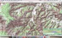
Looking at a detail topo map, it looks like there are other canyons which could be hiding lots of things but don't have a designated trail in them anymore. Perhaps they did once when there was cattle grazing. An example is West Fork of Salt Creek. Looks like there was an old route in there a long time ago. Either way, the canyon looks almost as large as the East Fork and it seems hard to imagine there aren't also great things to see in there. I imagine it is a lot of bushwacking. Know anything about it?Screen Shot 2015-03-24 at 1.17.18 PM.png
 
They also mentioned the road to Cathedral Butte was impassible until a week ago due to snow and mud. That would have made anyone doing a through hike SOL.

I've heard about them telling people that road is impassable when it is just fine. That and some other things I've heard from people sometimes makes me think they just don't want you to go out there. Lots of stories of inflated dangers. But I guess danger is relative to experience and preparedness.

I saw distant ruins in my telephoto lens up some of those big western side canyons.
 
I was there at the beginning of March and had to park 2 miles from Cathedral Butte. I had to cancel once due to the snow and had no problems with permits. They credited the first set to my next trip without even being asked. I was down three nights and didn't see a soul till hiking out. I did an up and back from Cathedral Butte to Angel Arch. Amazing place! There were still ammo boxes in SC 3 and 4.
 
A few miles of hiking can be knocked off of this trip by descending at Big Pocket Overlook. It requires real 4x4.

Bumping an old thread here. I'm headed to this hike next week. This is what I'm most curious about- Descending at Big Pocket Overlook. I like the idea of Big views of the canyon before dropping down into it.

Does anyone know of the route? I can't find anything for it.
 
Bumping an old thread here. I'm headed to this hike next week. This is what I'm most curious about- Descending at Big Pocket Overlook. I like the idea of Big views of the canyon before dropping down into it.

Does anyone know of the route? I can't find anything for it.

Drive all the way to the end. There will be a broken picnic table there. Walk the rim to the right (east). I've seen people come up and down within 30 yards or so of the campsite. Found bicycles left there. Haven't looked for cairns but I suspect that is the best way off the point.
 
Drive all the way to the end. There will be a broken picnic table there. Walk the rim to the right (east). I've seen people come up and down within 30 yards or so of the campsite. Found bicycles left there. Haven't looked for cairns but I suspect that is the best way off the point.

Thanks!
 

Don't like ads? Become a BCP Supporting Member and kiss them all goodbye. Click here for more info.

Back
Top