balzaccom
Member
- Joined
- Sep 30, 2014
- Messages
- 839
With only a few more days before school starts, we wanted to get one last trip into the Sierra, and headed for Sabrina Basin. We'd hiked out of both North Lake and South Lake, so this was the last of the three trailheads for us to explore. 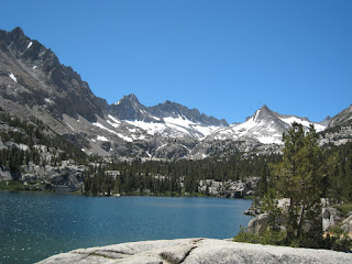 Day One: It was a long drive from Napa over Echo Summit and Monitor Pass to the Mono Lake Ranger Station, where we got our permit at about 1 p.m. There were still plenty of spaces available for both Monday and Tuesday, so we felt sure that it wouldn't be too crowded. After a quick bite at the Lee Vining Mobil Station, we drove down to Bishop to buy a few last minute supplies (a dinner for that night, a hair clip for M, and an extra bottle of Advil for our aching bones) and set up camp in the Sabrina Lake Campground. There were still places available here at 5 p.m. and we took a short walk around the area and settled in to an early night.
 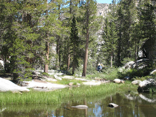 Day Two: We packed up and parked Le Vin Blanc on the road right outside the campground, then hit the trail by 9 a.m. Fishermen were already on the lake as we slowly climbed up past the trail to Lake George and onwards to Blue Lake. We got there in time for an early lunch, and probably should have taken a short rest at that point. But we didn't. The mosquitoes were not too bad in the middle of the afternoon, and we pushed on past Emerald Lakes to Dingleberry Lake.
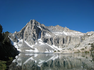
  There were a few campers on the granite ledges above the South end of the lake, and we half-heartedly looked for a campsite on the North end. But that was pretty rugged terrain. We wandered along the creek beyond the lake, and finally settled on a campsite overlooking the two fords of the creek: one for hikers, one for stock. It was a pretty spot, with shade in the afternoon for our nap, and nice views all the way around.
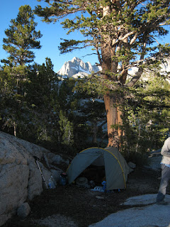
We set up camp, napped, fished, rested, and generally felt a bit worn out after only five miles of hiking. But that comes with age, we suppose. That night the mosquitoes made their presence known in spades, and we turned in early to escape them. Still, it was lovely country, and the weather was perfect: warm in the sun, cool in the shade.
 Day Three; instead of packing up, we left our camp set up and day-hiked up to the lakes above. After fording the creek, we ran into a wilderness ranger doing trail work. In addition to sharing our experiences working on trails, we got our permit checked and had a nice chat. On our permit we had initially named Topsy-Turvy Lake as our destination, but we were happy with our campsite at the fords. And when we saw Topsy Turvy Lake, we were even happier with our decision. While it was beautiful, there didn't seem to be many campsites at Topsy Turvy amid the vast fields of talus--although there might have been a few above the lake on the South side--and they would have been very exposed. We like shade.
 From there we continued on to Sailor Lake, and then topped out at Hungry Packer Lake, which had apparently earned the name Hungry Mosquito Lake this year. The bugs were absolutely fierce. We were hiking in headnets and DEET, and it really helped to keep moving! Which we did. Lots of people camped around here, by the way. We hiked cross-country over to Moonlight Lake and had a nice rest and snack sitting among the huge talus blocks above that lake. Then we continued down the granite slabs to Sailor Lake again, and back down to our camp.
It was interesting that the ford, which was about 75 feet long over a long string of rocks, was drier later in the day, and wetter earlier in the day. Clearly the snowmelt was taking twelve hours to get down the creek to the ford. After lunch and a nap, we decided we'd explore Dingleberry Lake some more. While much of the shoreline was rugged, we did manage to find a route down from the trail to the North end of the lake, where there was a lovely pool, and a series of campsites further out above the canyon beyond the outlet stream. This would make a nice base camp, and it seemed to get little traffic. Back at camp that night, we dodged and swatted the bugs, ate our dinner, and again headed to the tent just about dusk, leaving the field to the pesky mosquitoes.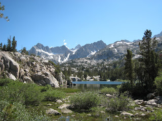 Day Four: We'd heard that Donkey Lake had fewer mosquitoes, and since that was also on our itinerary, we headed there next. The trail back down to Blue Lake is really beautiful, and we enjoyed it much more in this direction. Once at the junction, we took the trail towards Donkey Lake, and were surprised to see a second junction only 1/4 mile later to Baboon Lakes. On our topo map, and on the Tom Harrison map, this junction is much higher up, right where the trail crosses the creek. Hmmm. Oh well. Nothing like confusion!
 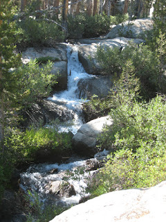 We continued on to Donkey Lake, absolutely loving the scenery of the creek as we followed it up the canyon past pools, cascades and rapids. And Donkey Lake was charming. We set up camp and went to explore a bit, doing some fishing, filtering water, and getting a feel for the place. The lake was so clear and there were so many trout on the surface that at times it looked like an aquarium. After lunch and our usual nap, we headed back down the hill 1/2 mile to pick up the trail that was shown on our maps to Baboon Lakes.
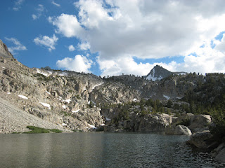 What a bushwhack! We followed cairns and blazes; struggled, clambered, and finally found a section of trail that looked reasonable. After about an hour, and at least one conversation about turning around, we topped out on the crest of a ridge, and there was Baboon Lake. Spectacular! We wandered around the lake for quite a while before exploring different routes down. We could not believe that was the only trail! But as we explored, we found an easier down to the trail, and as I watched our progress and took in our surroundings, I suddenly exclaimed: "Donkey Lake is right over there!"
 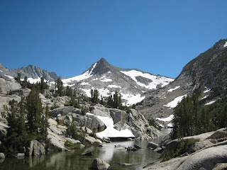 I was right. It was just 75 yards from where we had found the first real section of cairns to follow...and the whole first part of our hike up to Baboon Lakes had been a complicated and unnecessary circle. For those who are interested, if you find the small round pond just West of Donkey Lake, you can follow a series of cairns southwest up that ridge, over into the next chute, and at the top of that chute the cairns will lead you into the main chute that takes you up to Baboon Lakes. It's steep, but passable and clearly marked. And while it took us just over an hour to get up to the lakes, it took us only 25 minutes to get down, once we understood the geography.
 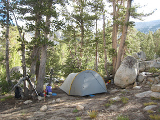 (BTW, the other, signed trail to Baboon Lakes from near Blue Lake must take a very different route---but we never saw it, even though we looked for that trail up at the lake itself. We assume that it stays west of the creek the whole way up...) Great fishing that afternoon in Donkey Lake for brookies and rainbows from 6-10 inches long...and almost non-stop action. That evening we fought the bugs one last time, finally giving up around 8 o'clock to get into the tent.
 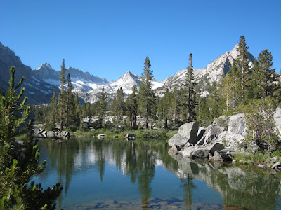 Day Five: It's always easier downhill, unless the steps are really tall. So we were back at the trailhead by eleven a.m., knees a bit sore from all the steps, but happy enough with a really magical trip. We drove into Bishop, grabbed a bite to eat at the Burger Barn, and then drove back to our cabin above Sonora in time for fresh salad, sushi, and showers. What a great trip.
The full photo report is here: https://photos.app.goo.gl/bZbDv9vXvaMXsita9
Day One: It was a long drive from Napa over Echo Summit and Monitor Pass to the Mono Lake Ranger Station, where we got our permit at about 1 p.m. There were still plenty of spaces available for both Monday and Tuesday, so we felt sure that it wouldn't be too crowded. After a quick bite at the Lee Vining Mobil Station, we drove down to Bishop to buy a few last minute supplies (a dinner for that night, a hair clip for M, and an extra bottle of Advil for our aching bones) and set up camp in the Sabrina Lake Campground. There were still places available here at 5 p.m. and we took a short walk around the area and settled in to an early night. Day Two: We packed up and parked Le Vin Blanc on the road right outside the campground, then hit the trail by 9 a.m. Fishermen were already on the lake as we slowly climbed up past the trail to Lake George and onwards to Blue Lake. We got there in time for an early lunch, and probably should have taken a short rest at that point. But we didn't. The mosquitoes were not too bad in the middle of the afternoon, and we pushed on past Emerald Lakes to Dingleberry Lake. There were a few campers on the granite ledges above the South end of the lake, and we half-heartedly looked for a campsite on the North end. But that was pretty rugged terrain. We wandered along the creek beyond the lake, and finally settled on a campsite overlooking the two fords of the creek: one for hikers, one for stock. It was a pretty spot, with shade in the afternoon for our nap, and nice views all the way around. We set up camp, napped, fished, rested, and generally felt a bit worn out after only five miles of hiking. But that comes with age, we suppose. That night the mosquitoes made their presence known in spades, and we turned in early to escape them. Still, it was lovely country, and the weather was perfect: warm in the sun, cool in the shade.
Day Three; instead of packing up, we left our camp set up and day-hiked up to the lakes above. After fording the creek, we ran into a wilderness ranger doing trail work. In addition to sharing our experiences working on trails, we got our permit checked and had a nice chat. On our permit we had initially named Topsy-Turvy Lake as our destination, but we were happy with our campsite at the fords. And when we saw Topsy Turvy Lake, we were even happier with our decision. While it was beautiful, there didn't seem to be many campsites at Topsy Turvy amid the vast fields of talus--although there might have been a few above the lake on the South side--and they would have been very exposed. We like shade. From there we continued on to Sailor Lake, and then topped out at Hungry Packer Lake, which had apparently earned the name Hungry Mosquito Lake this year. The bugs were absolutely fierce. We were hiking in headnets and DEET, and it really helped to keep moving! Which we did. Lots of people camped around here, by the way. We hiked cross-country over to Moonlight Lake and had a nice rest and snack sitting among the huge talus blocks above that lake. Then we continued down the granite slabs to Sailor Lake again, and back down to our camp. It was interesting that the ford, which was about 75 feet long over a long string of rocks, was drier later in the day, and wetter earlier in the day. Clearly the snowmelt was taking twelve hours to get down the creek to the ford. After lunch and a nap, we decided we'd explore Dingleberry Lake some more. While much of the shoreline was rugged, we did manage to find a route down from the trail to the North end of the lake, where there was a lovely pool, and a series of campsites further out above the canyon beyond the outlet stream. This would make a nice base camp, and it seemed to get little traffic. Back at camp that night, we dodged and swatted the bugs, ate our dinner, and again headed to the tent just about dusk, leaving the field to the pesky mosquitoes.
Day Four: We'd heard that Donkey Lake had fewer mosquitoes, and since that was also on our itinerary, we headed there next. The trail back down to Blue Lake is really beautiful, and we enjoyed it much more in this direction. Once at the junction, we took the trail towards Donkey Lake, and were surprised to see a second junction only 1/4 mile later to Baboon Lakes. On our topo map, and on the Tom Harrison map, this junction is much higher up, right where the trail crosses the creek. Hmmm. Oh well. Nothing like confusion! We continued on to Donkey Lake, absolutely loving the scenery of the creek as we followed it up the canyon past pools, cascades and rapids. And Donkey Lake was charming. We set up camp and went to explore a bit, doing some fishing, filtering water, and getting a feel for the place. The lake was so clear and there were so many trout on the surface that at times it looked like an aquarium. After lunch and our usual nap, we headed back down the hill 1/2 mile to pick up the trail that was shown on our maps to Baboon Lakes.What a bushwhack! We followed cairns and blazes; struggled, clambered, and finally found a section of trail that looked reasonable. After about an hour, and at least one conversation about turning around, we topped out on the crest of a ridge, and there was Baboon Lake. Spectacular! We wandered around the lake for quite a while before exploring different routes down. We could not believe that was the only trail! But as we explored, we found an easier down to the trail, and as I watched our progress and took in our surroundings, I suddenly exclaimed: "Donkey Lake is right over there!" I was right. It was just 75 yards from where we had found the first real section of cairns to follow...and the whole first part of our hike up to Baboon Lakes had been a complicated and unnecessary circle. For those who are interested, if you find the small round pond just West of Donkey Lake, you can follow a series of cairns southwest up that ridge, over into the next chute, and at the top of that chute the cairns will lead you into the main chute that takes you up to Baboon Lakes. It's steep, but passable and clearly marked. And while it took us just over an hour to get up to the lakes, it took us only 25 minutes to get down, once we understood the geography. (BTW, the other, signed trail to Baboon Lakes from near Blue Lake must take a very different route---but we never saw it, even though we looked for that trail up at the lake itself. We assume that it stays west of the creek the whole way up...) Great fishing that afternoon in Donkey Lake for brookies and rainbows from 6-10 inches long...and almost non-stop action. That evening we fought the bugs one last time, finally giving up around 8 o'clock to get into the tent. Day Five: It's always easier downhill, unless the steps are really tall. So we were back at the trailhead by eleven a.m., knees a bit sore from all the steps, but happy enough with a really magical trip. We drove into Bishop, grabbed a bite to eat at the Burger Barn, and then drove back to our cabin above Sonora in time for fresh salad, sushi, and showers. What a great trip. The full photo report is here: https://photos.app.goo.gl/bZbDv9vXvaMXsita9