OldBill
Member
- Joined
- Aug 18, 2015
- Messages
- 565
Spent September in the Wind Rivers: 10 days with girlfriend, 10 with nephew and last 10 solo. About 100 miles with 3 backpacks and a few day hikes.
Rough start. Girlfriend's flight to Jackson was delayed 12 hours. I'd flown to Salt Lake the day before. Picked her up at 10:30pm, got into Lander at 1am. She still wanted to try an easy 3 day backpack without being acclimated, despite repeated warnings. We left the next day for “the other” Island Lake.
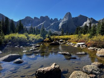
Easy 6 m hike in. Lost my hat near Upper Silas. Was looking forward to fishing Thumb the following day.


Plans changed when she woke the next morning with altitude sickness. I carried as much of the gear as I could and we started back down...slowly. “Never again” got repeated a lot... Island is at 10,600'. She felt better at the trailhead (~9400') and much better as we drove down to Lander. The extra night I had in Kemmerer (~7000') paid off; had no issues myself. Spent night in Lander then camp at Fremont L near Pinedale.


After Labor Day, started a backpack to Titcomb as our 2020 attempt was stopped by the historic windstorm. Had a busy trail the first 5 miles with lots of reminders of the work the FS did clearing that trail.


After Eklund L we saw only 4 others, 2 being Forest Service employees out cleaning camps. Lots of giant mushrooms that I don't recall ever seeing before. Wet year?


Had hoped to camp at Upper Cook, but it was clear that we'd only make it as far as Lower Cook. Nice spot.


The trail officially ends at Upper Cook but the use trail is easily followed.


Made our way over the ledges east of Wall Lake. Ran into 3 others at the top of the lake. Said they were climbing Ellingwood (Harrower). We continued on to Wall/Island Pass.


Crossed the inlet and headed towards the Harrower hanging valley. It's about a 400' climb to the valley, mostly open. Got bogged down in some willows.


Looking back towards Wall L.

Once in the hanging valley, it's wide open, but marshy in spots. Next 350' was steeper but easy footing, at least on the N side of point 11,200'.

About 100' from the top she had to rest and refuel. Then it's an easy drop to Island. While easy by Winds standards, the route still was harder than I had thought it would be. It was nice to have the pass entirely to ourselves.


Passed at least 10 camps as we went on the N side of Island. Found a site just off a use trail . Not much privacy, but a great view.


Rose to clouds building in the morning. We got a late start but went as far as the second lake.


I fished for an hour with no luck. The sky continued to darken and the wind was picking up so we decided to head back.


Were just cleaning up after dinner when the rain and hail started. Finished about 15 minutes later but the Basin was getting slammed. Enjoyed a nice sunset.


Set off about 10. We could do a 12 m exit or spend another night out. All the up and down of the Seneca L trail gets tiring. Made Eklund by late afternoon so it made sense to exit.

After a night in Pinedale, we headed to Colter Bay CG in Grand Teton NP. My nephew arrived that night.

Took an acclimation hike on a hazy day around Two Oceans L, then a more challenging hike to Holly Lake the day after. I stopped about 5 miles in. Evidently my nephew had no problem with acclimation. He went the extra ~2 steep miles and caught back up with us as we headed back.


It started raining that afternoon. Unsettled weather was predicted for the next week. Had routes for Bear Basin, Horse Ridge and Bull Lake Creek. Wanted a 5 day window of great weather for those. Opted for Plan D: a loop over Washakie Pass and Lizard Head, through the Cirque. He hadn't seen the Cirque and I hadn't been over Washakie or Lizard Head.
My girlfriend left on an early morning flight. Drove to Pinedale and spent next 2 days getting supplies and sitting out the rain. Forecasts said light rain for our start day, then good until late on exit day 5.
Forecast was off by a lot. Snow and rain showers the entire day. By Mirror L my socks were getting wet and my GTX-lined boots were only a month old. My nephew's 6 yr old GTX boots were fine. Trudged on to set up at Skull L.


By that time my feet were numb. The rain let up so we got a fire going. Took some doing (red-dead pine needle clusters make great starter). Dried socks and boots as best we could. 2 hours later the rain started again so we covered gear and dove into the tents.

The rain had stopped the next morning so we headed to East Fork. Nephew was seriously impressed as we came over the pass at Midsummer Dome. Best views since we went with @Bob to Lee Lake. Didn't venture far – just spent time relaxing. Then sky got darker and wind picked up so we headed back.


Raining again around sunset. Changed to sleet/snow and kept up for most of the night. Certainly not in the forecast. Woke to see the tent sagging from snow/ice buildup. Cleared what I could from inside, then dozed off.

Cleared more snow and ice off in the morning. About 1/4” snow/slush on the ground. The foot of the tent had a 1” puddle with 1/4” of ice on top. But, the sun was finally out. Laid out gear to dry and discussed options. Guessed Washakie and Lizard Head would have snow and ice for a day or 2 and didn't know what S. Fk crossing would be like. Wished I'd researched it more, but this was Plan D after all.


Decided to shorten the loop - camp at Shadow L then cross Texas Pass to the Cirque. That would give time for Texas to mostly clear. Been over Texas and didn't remember it being difficult footing. Plus the backside of the Cirque is great scenery. So, onto Plan E...


Found a really nice campsite at Shadow L, near running water, well above the lake but with a rock outcrop for views of the peaks. After setting up I explored the trail up to Billy's L - saw a group of 4 just setting up camp.


Woke to our second day of spectacular weather. Boots were finally dry. Spirits were up and we headed out. Stopped to photograph a few waterfalls along the way.


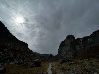
When we got to Texas L my nephew got a good look at the pass and a few folks on it. Said something like “Dang! That's climbing, not hiking.” Since it is a big climbing area, had to check map to be certain it was indeed Texas Pass. Yep. Didn't remember it being that steep.


Hiker on top of Texas and group about 1/4 below.

There's a path that's easy to follow for the most part, but there were some sections required picking a route over boulders and bypassing some icy patches. Got off route a couple of times - took some careful work to get to a safer spot. At the top my nephew said that was the scariest thing I've had him do yet. Think that means it was fun.


Easy descent to Lonesome L. As expected there were plenty of others around. 3 groups at the lake asked questions about area and routes. Hopefully I gave them useful info. It was clear only one had done adequate prep work. They were doing our Plan D route in reverse.


Saw one large group camped within 100 yds of the lake, with a big bonfire going. This despite signs all over stating camping isn't allowed in 1/4 mile of the lake. My feelings about that are best left unsaid...
Set up our site about 1/2 mile away with plenty of time to relax. A lot of scat around between camp and the river so wildlife apparently liked that location as well.


Heard elk bugling nearby the next morning so thought I'd try to get a photo. Found 2 guys using a call to get the bull closer. The exchange went on for awhile but the bull didn't appear.

Headed towards Jackass Pass. Talked to a group that had come over Washakie and Lizard Head after the storm. Said parts were “pretty sketchy”. Didn't cross S. Fk - used an off trail route to Lizard Head from Valentine. Didn't sound like they wanted to repeat it though.


Route around North Lake occasionally disappears in the boulders but that's the only real challenge.

Like most exits, it gets boring. Conversation became mostly guesses as to when the trail would end. Did see the 2 guys that said they were going over Lizard Head. They were ahead of us, moving fast. Might have bailed due to updated forecast. That sunscreen I use makes me look like the Joker...or a really OldBill

Waited out yet more rain in town. A guy staying at our motel had a car breakdown (think at Big Sandy). Had a tough time getting anyone to tow car. Finally found one - for $800. Waited a week for a part and the repair. Apparently, insurance wasn't covering the tow or motel. Note to self: check insurance coverage in similar situation with a rental.
Decided to see Slide Falls. Been to the Natural Bridge plenty of times but had never been to the Falls. Bridge is still gone, but it's an easy wade across Clear Ck. My nephew managed to cross the creek above the falls to get a better photo.


After I dropped off nephew at airport I headed to Dubois to fish the Wind and East Fk Rivers. Unfortunately, the rivers were still blown out from the rain. Fly fishing store suggested Horse Ck. Fond memories of the T-Cross Ranch that I stayed at many times long ago. No fish tho...


Chatted with a fellow at the Longhorn Campground who caught a dozen good fish that same day. A guide took him to streams towards Union Pass. The same outfit sent me in the opposite direction... Decided to head to East Fk. Spent a few hours at 3 locations before finally landing a solid 16” cutt.


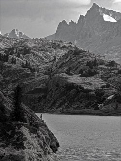
Wanted to spend the remaining time fishing Thumb L. Went back to Lander and set up at Island L in the same spot. Only 1 other car at the trailhead - didn't see anyone all day.

Found the use trail to Thumb the next morning. It disappeared several times and sometimes there were multiple paths, but for the most part matched up with the Caltopo route. Was windy and didn't see any fish cruising so fished a Jake's Money Clip at various depths, then tied on a scud behind a spoon. No action, but the scenery and isolation were great.


Finally headed back to camp to get out of the wind. Fished Island L until dusk and finally caught a small cutt using a streamer. Wouldn't touch anything else I tried.

Once again, the forecast came up short. The rain came 20 hours early. Packed up camp for a quick start in the morning. Gusts were shaking the tent pretty good. Rained off/on all night. Got up at sunrise when showers let up. Don't think I ever packed that fast before. Something had chewed the ends of my groundsheet that night.

By the time I got to the established trail the weather started to clear. Pulled off rain gear and ate breakfast - missed my morning coffee. Passed a trail runner a mile below Upper Silas L – first person in 3 days.
Back in town, dried out my gear and watched the storm build over the range. By mid-afternoon the storm reached town so I felt fortunate to have a dry exit. Packed up and got ready for the long drive to Salt Lake and return home. I was flying through Charlotte, NC which had a hurricane headed towards it.
No golden again this year. Looking forward a return and another try.
Rough start. Girlfriend's flight to Jackson was delayed 12 hours. I'd flown to Salt Lake the day before. Picked her up at 10:30pm, got into Lander at 1am. She still wanted to try an easy 3 day backpack without being acclimated, despite repeated warnings. We left the next day for “the other” Island Lake.
Easy 6 m hike in. Lost my hat near Upper Silas. Was looking forward to fishing Thumb the following day.
Plans changed when she woke the next morning with altitude sickness. I carried as much of the gear as I could and we started back down...slowly. “Never again” got repeated a lot... Island is at 10,600'. She felt better at the trailhead (~9400') and much better as we drove down to Lander. The extra night I had in Kemmerer (~7000') paid off; had no issues myself. Spent night in Lander then camp at Fremont L near Pinedale.
After Labor Day, started a backpack to Titcomb as our 2020 attempt was stopped by the historic windstorm. Had a busy trail the first 5 miles with lots of reminders of the work the FS did clearing that trail.
After Eklund L we saw only 4 others, 2 being Forest Service employees out cleaning camps. Lots of giant mushrooms that I don't recall ever seeing before. Wet year?
Had hoped to camp at Upper Cook, but it was clear that we'd only make it as far as Lower Cook. Nice spot.
The trail officially ends at Upper Cook but the use trail is easily followed.
Made our way over the ledges east of Wall Lake. Ran into 3 others at the top of the lake. Said they were climbing Ellingwood (Harrower). We continued on to Wall/Island Pass.
Crossed the inlet and headed towards the Harrower hanging valley. It's about a 400' climb to the valley, mostly open. Got bogged down in some willows.
Looking back towards Wall L.
Once in the hanging valley, it's wide open, but marshy in spots. Next 350' was steeper but easy footing, at least on the N side of point 11,200'.
About 100' from the top she had to rest and refuel. Then it's an easy drop to Island. While easy by Winds standards, the route still was harder than I had thought it would be. It was nice to have the pass entirely to ourselves.
Passed at least 10 camps as we went on the N side of Island. Found a site just off a use trail . Not much privacy, but a great view.
Rose to clouds building in the morning. We got a late start but went as far as the second lake.
I fished for an hour with no luck. The sky continued to darken and the wind was picking up so we decided to head back.
Were just cleaning up after dinner when the rain and hail started. Finished about 15 minutes later but the Basin was getting slammed. Enjoyed a nice sunset.
Set off about 10. We could do a 12 m exit or spend another night out. All the up and down of the Seneca L trail gets tiring. Made Eklund by late afternoon so it made sense to exit.
After a night in Pinedale, we headed to Colter Bay CG in Grand Teton NP. My nephew arrived that night.
Took an acclimation hike on a hazy day around Two Oceans L, then a more challenging hike to Holly Lake the day after. I stopped about 5 miles in. Evidently my nephew had no problem with acclimation. He went the extra ~2 steep miles and caught back up with us as we headed back.
It started raining that afternoon. Unsettled weather was predicted for the next week. Had routes for Bear Basin, Horse Ridge and Bull Lake Creek. Wanted a 5 day window of great weather for those. Opted for Plan D: a loop over Washakie Pass and Lizard Head, through the Cirque. He hadn't seen the Cirque and I hadn't been over Washakie or Lizard Head.
My girlfriend left on an early morning flight. Drove to Pinedale and spent next 2 days getting supplies and sitting out the rain. Forecasts said light rain for our start day, then good until late on exit day 5.
Forecast was off by a lot. Snow and rain showers the entire day. By Mirror L my socks were getting wet and my GTX-lined boots were only a month old. My nephew's 6 yr old GTX boots were fine. Trudged on to set up at Skull L.
By that time my feet were numb. The rain let up so we got a fire going. Took some doing (red-dead pine needle clusters make great starter). Dried socks and boots as best we could. 2 hours later the rain started again so we covered gear and dove into the tents.
The rain had stopped the next morning so we headed to East Fork. Nephew was seriously impressed as we came over the pass at Midsummer Dome. Best views since we went with @Bob to Lee Lake. Didn't venture far – just spent time relaxing. Then sky got darker and wind picked up so we headed back.
Raining again around sunset. Changed to sleet/snow and kept up for most of the night. Certainly not in the forecast. Woke to see the tent sagging from snow/ice buildup. Cleared what I could from inside, then dozed off.
Cleared more snow and ice off in the morning. About 1/4” snow/slush on the ground. The foot of the tent had a 1” puddle with 1/4” of ice on top. But, the sun was finally out. Laid out gear to dry and discussed options. Guessed Washakie and Lizard Head would have snow and ice for a day or 2 and didn't know what S. Fk crossing would be like. Wished I'd researched it more, but this was Plan D after all.
Decided to shorten the loop - camp at Shadow L then cross Texas Pass to the Cirque. That would give time for Texas to mostly clear. Been over Texas and didn't remember it being difficult footing. Plus the backside of the Cirque is great scenery. So, onto Plan E...
Found a really nice campsite at Shadow L, near running water, well above the lake but with a rock outcrop for views of the peaks. After setting up I explored the trail up to Billy's L - saw a group of 4 just setting up camp.
Woke to our second day of spectacular weather. Boots were finally dry. Spirits were up and we headed out. Stopped to photograph a few waterfalls along the way.
When we got to Texas L my nephew got a good look at the pass and a few folks on it. Said something like “Dang! That's climbing, not hiking.” Since it is a big climbing area, had to check map to be certain it was indeed Texas Pass. Yep. Didn't remember it being that steep.
Hiker on top of Texas and group about 1/4 below.
There's a path that's easy to follow for the most part, but there were some sections required picking a route over boulders and bypassing some icy patches. Got off route a couple of times - took some careful work to get to a safer spot. At the top my nephew said that was the scariest thing I've had him do yet. Think that means it was fun.
Easy descent to Lonesome L. As expected there were plenty of others around. 3 groups at the lake asked questions about area and routes. Hopefully I gave them useful info. It was clear only one had done adequate prep work. They were doing our Plan D route in reverse.
Saw one large group camped within 100 yds of the lake, with a big bonfire going. This despite signs all over stating camping isn't allowed in 1/4 mile of the lake. My feelings about that are best left unsaid...
Set up our site about 1/2 mile away with plenty of time to relax. A lot of scat around between camp and the river so wildlife apparently liked that location as well.
Heard elk bugling nearby the next morning so thought I'd try to get a photo. Found 2 guys using a call to get the bull closer. The exchange went on for awhile but the bull didn't appear.
Headed towards Jackass Pass. Talked to a group that had come over Washakie and Lizard Head after the storm. Said parts were “pretty sketchy”. Didn't cross S. Fk - used an off trail route to Lizard Head from Valentine. Didn't sound like they wanted to repeat it though.
Route around North Lake occasionally disappears in the boulders but that's the only real challenge.
Like most exits, it gets boring. Conversation became mostly guesses as to when the trail would end. Did see the 2 guys that said they were going over Lizard Head. They were ahead of us, moving fast. Might have bailed due to updated forecast. That sunscreen I use makes me look like the Joker...or a really OldBill
Waited out yet more rain in town. A guy staying at our motel had a car breakdown (think at Big Sandy). Had a tough time getting anyone to tow car. Finally found one - for $800. Waited a week for a part and the repair. Apparently, insurance wasn't covering the tow or motel. Note to self: check insurance coverage in similar situation with a rental.
Decided to see Slide Falls. Been to the Natural Bridge plenty of times but had never been to the Falls. Bridge is still gone, but it's an easy wade across Clear Ck. My nephew managed to cross the creek above the falls to get a better photo.
After I dropped off nephew at airport I headed to Dubois to fish the Wind and East Fk Rivers. Unfortunately, the rivers were still blown out from the rain. Fly fishing store suggested Horse Ck. Fond memories of the T-Cross Ranch that I stayed at many times long ago. No fish tho...
Chatted with a fellow at the Longhorn Campground who caught a dozen good fish that same day. A guide took him to streams towards Union Pass. The same outfit sent me in the opposite direction... Decided to head to East Fk. Spent a few hours at 3 locations before finally landing a solid 16” cutt.
Wanted to spend the remaining time fishing Thumb L. Went back to Lander and set up at Island L in the same spot. Only 1 other car at the trailhead - didn't see anyone all day.
Found the use trail to Thumb the next morning. It disappeared several times and sometimes there were multiple paths, but for the most part matched up with the Caltopo route. Was windy and didn't see any fish cruising so fished a Jake's Money Clip at various depths, then tied on a scud behind a spoon. No action, but the scenery and isolation were great.
Finally headed back to camp to get out of the wind. Fished Island L until dusk and finally caught a small cutt using a streamer. Wouldn't touch anything else I tried.
Once again, the forecast came up short. The rain came 20 hours early. Packed up camp for a quick start in the morning. Gusts were shaking the tent pretty good. Rained off/on all night. Got up at sunrise when showers let up. Don't think I ever packed that fast before. Something had chewed the ends of my groundsheet that night.
By the time I got to the established trail the weather started to clear. Pulled off rain gear and ate breakfast - missed my morning coffee. Passed a trail runner a mile below Upper Silas L – first person in 3 days.
Back in town, dried out my gear and watched the storm build over the range. By mid-afternoon the storm reached town so I felt fortunate to have a dry exit. Packed up and got ready for the long drive to Salt Lake and return home. I was flying through Charlotte, NC which had a hurricane headed towards it.
No golden again this year. Looking forward a return and another try.
Attachments
Last edited: