John Fowler
Member
- Joined
- Jan 17, 2012
- Messages
- 217
On Sunday, May 6, my wife Jo and I picked up ladigue_99 (henceforth known as Ladigue) at the Albuquerque airport. She was arriving from Italy for a two-week journey through the southwest. Jo accompanied us for the first leg of the trip, to White Sands, and then departed for her own adventure in Orlando. This report of Ladigue’s and my adventure over the next two weeks will be presented here in parts. I will add subsequent installments as additions to this thread as I get them written.
Note: Ladigue’s comments will be posted in blue. Some of these photos were taken by Ladigue, and some by me.
Ladigue has seen more of the area than I have, so it was definitely not a case of me showing her the sights. We stayed in motels except for one night of camping at White Pocket.
Ladigue: Actually I had seen the main tourist attractions, National Parks and the big cities, but this time John showed me the most secluded geologic wonders, that I would never have seen without his knowledge of the trails and his GPS!
On May 7 we set out for White Sands. Our first stop was Valley of Fires Recreation Area, among the lava flows of the Tularosa Valley, just outside Carrizozo, NM. (Don’t confuse the name with Valley of Fires State Park, in Nevada. We’ll get there eventually.) The site, run by the BLM, has a walking path about half a mile long. Colorful cactus blooms decorated the dark gray lava forms.
Ladigue: Having always travelled in July/September, this year I saw for the first time the different cacti in full bloom, what a treat!

Then we checked in at the motel in Alamogordo and took the 20-mile drive out to White Sands National Monument. There were nice mid-afternoon clouds and we strolled around for a while taking photos before returning to Alamogordo for dinner.

Afterwards, the sky became darker as blustery winds picked up the sand and carried it around. Ladigue and I decided to drive back out to the sands for sunset.
As we were walking among the dunes the wind was blowing in gusts, raising diaphanous sheets of fine gypsum sand into the air and moving them by like spirit ghosts before dissipating into the air.

At one moment, a sudden sweet aroma filled the air. I looked down into the bowl in front of me to see hundreds of pink flowers about 50 feet below. Then, as fast as it came, the perfume was gone.

Suddenly the wind gusted and I could see a wall of gypsum coming toward me. I hastened down the slope into a bowl for cover, but I didn't make it. Suddenly the wind was howling around me and I had to stop and brace myself. My eyes were closed. Ladigue, standing next to me, said that for a few seconds there was a complete white-out. She couldn't see me two feet away.

Then a very strange, almost mystical, event unfolded. The gypsum-laden wind swirling around me became wet. The dampness gave a heft to the air and I could feel it like a cloth rubbing around me. It was exhilarating. Then it was over.
Ladigue said it best. She called it a caress.
Ladigue: It surprised me that this sand didn’t hurt, I had experienced a sand storm in Namibia and it hurt like needles on my skin scorched by the sun!

The next day we drove back to our home in Placitas, were we spent the night. Along the way we stopped about 20 miles south of Socorro to walk over to Greg Reiche's 30 foot tall steel and glass sculpture, "Camino de Suenos", just a few hundred feet east I-25 and seeming to rise up out of the ground.

Then we drove on through Bosque del Apache. The birds of winter are long gone, but we saw a few herons, ducks, and turtles, and several deer.

Ladigue: And you showed me the lovely little town of Truth or Consequences! When I was a child I read its name on a map and I wanted to see how it looked.

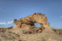
On Wednesday, May 9, Ladigue and I got in the Tundra and began the rest of our trip, heading northwest up US 550. Our first destination was Ah-Shi-Sle-Pah, a Wilderness Study Area that is like the Bisti badlands but much smaller. I had been there once before, taking SR 50 at Blanco Trading Post, around marker 123, for 18 miles. This time I wanted to make a shortcut, leaving the highway at Nageezi. This part of the country is a maze of intersecting dirt roads of varying quality, only some of them marked with signs. But I had prepared a map and tried to check the quality of the roads beforehand by following them on Google Earth. And it worked! After about 16 miles we reached the double-track turnoff that leads north for about half a mile, right up to the canyon edge. You are at the hoodoos as soon as you step out of the vehicle.

After a little climb down into the canyon, the route follows the wash westward for about a quarter of a mile, where the canyon opens up on the right side into a wide flat plain. The cliff walls on the left and the canyon floor contain many interesting formations for the next mile.


Notice my shoes in the next picture. I was lying on my back to get the shot of sky through the little opening in the rock. This may be where I picked up the bugs whose bites plagued me for the next few days. Remember these feet; we will encounter this strange phenomenon of shoe photography again in a few days at Cassidy Arch.

Eventually we turned around and retraced our path back up the wash and to the truck. Then, instead of returning to US 550, we continued northwest until we reached SR 371 going to Farmington. Along the way we passed a stock tank with about a dozen horses standing around. We stopped the truck and took some pictures as the horses approached.

Next we headed into Arizona and then up toward Bluff, UT. We drove around in Valley of the Gods and stopped at one point to walk up into one of the canyons on the west side.


Then it was on to Blanding for the night.
Ladigue: Where John was bitten by the bed bugs!
Well, actually, in all fairness to the motel, I think I got bitten while lying on the ground in Valley of the Gods taking pictures. At any rate, my arms and one leg and the top of my head broke out in isolated bumps that itched for several days.
On Thursday we headed up the road toward Moab, stopping at the Hole N the Rock for a few tourist photos.

Just past Moab, we turned on Potash Road and drove to the Corona Arch trailhead. On the hike out we encountered some folks from Brooklyn, NY. We passed them and reached the arch a little before noon. After taking some shots, we sat in the shade of the arch and ate our Subway sandwiches.


I noticed two young women beneath the arch. One of them was sitting on the ground, and beside her, the other was lying on her back with her feet up in the air. I said, "I'm not even going to ask", and the other girl replied that her friend photographs her shoes wherever she goes and puts the pictures on the Internet!
As we hiked back down the trail, we met more people heading in.
Then it was on to the Fisher Towers, along Route 128 northeast of Moab. This scenic road follows the Colorado River through winding canyons. I had wanted to see the towers after viewing the Citibank commercial with the climbers (Katie Brown and Alex Honnold) that ends with the woman standing on top of one of the tall, slender spires. The music is from "Into the Wild" by LP. If you're interested, you can find the commercial on youtube.
As we drove up the road to the parking lot, Ladigue spotted some unusual blooming cacti (she always sees these things first) and we stopped to take a few shots.


Then we took the trail around and into the towers. We saw a lizard and the first of several snakes (yellow and black, about five feet long) on this trip. The light was not the best for photography, but we grabbed a few "I was there" shots anyway.


We drove up to I-70 and back to Green River for the first of two nights.
The next day, Friday, May 11, we drove back to Arches National Park because Ladigue wanted to see Sand Dune Arch. She had been there a while back and wanted to see if the small cave at the base of the arch was visible. It was partially covered with sand the last time she was there. Alas, we found that the cave is no longer there.
Here’s Ladigue’s shot from 1997:

And mine from May 11:

The main event of the day was to be the hike to False Kiva in Island in the Sky. I had the GPS programmed with some waypoints along the trail. We stopped in the Visitor Center and asked if they had any special information, and were told just to be careful not to disturb the archeological work. We found the parking area and headed back up the road looking for signs of a trail. It hadn't rained in a while, so there were footprints all over the place. I wasn't expecting much of a trail, so the first place we came to that had more than the usual number of footprints seemed like the right place to leave the road. My guy-ness prevented me from checking the GPS. We turned too soon, a fact that became apparent after about a mile, when we came to the top of the mesa. We could see the trail about 100 feet away and maybe 300 feet below. So we backtracked, looking for a route down the mesa to the trail. We ended up walking all the way back to the highway. Actually, these "bonus miles" were fun too. The real trail turned out to be well-defined, and we made our way to False Kiva without further incident. I checked the GPS continually.
Ladigue: I must say that I really enjoyed the double hike!
It got kind of rocky near the end, but we didn't have any problems. As we approached, we saw a couple of guys on the way back. I asked them "Backcountrypost.com?", and got some funny looks. I guess not …
Ladigue: I think that Backcountrypost.com could also print some smaller stickers to put on the camera straps or on the backpack.
This shot is from the large alcove that you reach just before False Kiva, which is just to the left.

And here is Ladigue’s shot of False Kiva.

When we got there, we found a couple who had been there several times. We took some photos and observed that clouds were moving in. Soon there wasn't much blue sky left. We had the choice of sitting around until sunset and hoping that the clouds would blow away, or starting back to the truck. There was a military ammunition box in the back of the cave with some information about the place and a notebook where visitors could write comments. Some of them were interesting to read. Then we decided it was time to leave. Just before that, a young guy with what appeared to be a light set showed up. He didn't say anything, so I'm guessing that he was European and didn't speak much English. We encountered some light rain on the walk back.
Note: I made a 360 degree interactive VR movie of False Kiva. You can see it at my photo web site:
http://www.lumenetic.com/vr_files/falsekiva/falsekiva.htm
or, just go to www.lumenetic.com and click on “Virtual Reality” in the header to see all of my VR movies.
We drove over to the Green River Overlook and then down to Grand VIew Point before returning to Green River for the night.

On Saturday, May 12, we left Green River behind. Our first stop was Little Wild Horse Canyon. By the time we got there, about 30 vehicles filled the parking lot and people were starting to park along the road. There were lots of young families out for a day trip. After we got on the short trail to the canyon, we didn't see many people. Just past the entrance of the canyon there is a dryfall about eight feet high that can be climbed, or you can take a path up and around. We chose the path. We took our time, shooting many coves and rock formations. We continued into the second narrows until we reached the point where it would take a bit of climbing and turned around there.


On the way back, as we approached the dryfall from the top, a couple of teenagers came sprinting down the canyon. They ran right off the top of the dryfall and hit the ground at the bottom, barely missing a stride. Encouraged by this youthful show of elan and energy, I decided to try the dryfall myself. I sat on the top and gently moved down to a rock outcrop just below. My camera pack had me wedged in, and I was starting to slide off the rock. I began to worry that I could twist my ankle on the landing, so I shouted for Ladigue to help me get my pack off so that I could go back up. My arm got caught in the pack, but she got it off and I backed up onto the top. Then we took the path around.
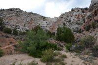
Then we went on to Capitol Reef. We stopped at the Visitor Center and asked about how to get to Cassidy Arch, since our map showed a couple of possibilities. We drove up the scenic drive and turned left onto the dirt road that led to the parking lot. The ranger had told us that about a third of a mile down the trail there would be a sign for the arch trail splitting off to the left. He said that the sign wasn't easy to spot. We looked for it but missed it because you can't see it until you are almost past it. Nevertheless, the views were majestic.

After about a mile, we turned around and found the trail marker on the way back. There we began the steep ascent to the arch.
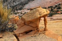
Along the way we saw some rocks with unusual interior structures.


Eventually we came around a curve and saw the arch not far away.

We continued on relatively level terrain but lost sight of the arch. We encountered one hiker who was returning and he encouraged us to continue to the end of the trail, which comes out behind and almost on top of the arch. Eventually we got there and decided that it was worth the effort to see down into the bottom.
In the next photo, Ladigue is sitting on top of the arch.

Just to the south side of the top there was a little depression with a couple of trees and a smaller (about one foot tall) arch.

Next we drove over to the Bentonite Hills area. There is a dirt road about ten miles east of the Visitor Center that soon crosses the Fremont River. The crossing is diagonal, with the exit about 100 feet downstream from the entrance. There was a fair amount of water in the river, so we got out of the truck and I waded halfway across to measure the depth. It came up to just below my knees, which I thought would be OK. When I got back to shore, Ladigue said "But you didn't go all the way across. It could be deeper near the other side." She had a point, so I waded back in and all the way to the other side.

Then we got in the truck and drove across without any problems. I think it would have been too deep for a vehicle with less clearance.
Ladigue: I’m probably too cautious!
After a few miles we arrived at the colorful Bentonite Hills. We walked around for about an hour late in the afternoon taking pictures. It was a bit of a disappointment for us. I'm sure there's a great picture there somewhere, but we didn't find it.


The road continues to Cathedral Valley, but it was too late for us so we turned around and drove to the Rodeway Inn in Caineville for the night. (Actually the Rodeway Inn IS Caineville. There's nothing else there.)
Ladigue: Actually I liked the colored hills near Old Paria much more than the Bentonite Hills!
Stay tuned! Part II coming soon.
Featured image for slideshow:

Note: Ladigue’s comments will be posted in blue. Some of these photos were taken by Ladigue, and some by me.
Ladigue has seen more of the area than I have, so it was definitely not a case of me showing her the sights. We stayed in motels except for one night of camping at White Pocket.
Ladigue: Actually I had seen the main tourist attractions, National Parks and the big cities, but this time John showed me the most secluded geologic wonders, that I would never have seen without his knowledge of the trails and his GPS!
On May 7 we set out for White Sands. Our first stop was Valley of Fires Recreation Area, among the lava flows of the Tularosa Valley, just outside Carrizozo, NM. (Don’t confuse the name with Valley of Fires State Park, in Nevada. We’ll get there eventually.) The site, run by the BLM, has a walking path about half a mile long. Colorful cactus blooms decorated the dark gray lava forms.
Ladigue: Having always travelled in July/September, this year I saw for the first time the different cacti in full bloom, what a treat!
Then we checked in at the motel in Alamogordo and took the 20-mile drive out to White Sands National Monument. There were nice mid-afternoon clouds and we strolled around for a while taking photos before returning to Alamogordo for dinner.
Afterwards, the sky became darker as blustery winds picked up the sand and carried it around. Ladigue and I decided to drive back out to the sands for sunset.
As we were walking among the dunes the wind was blowing in gusts, raising diaphanous sheets of fine gypsum sand into the air and moving them by like spirit ghosts before dissipating into the air.
At one moment, a sudden sweet aroma filled the air. I looked down into the bowl in front of me to see hundreds of pink flowers about 50 feet below. Then, as fast as it came, the perfume was gone.
Suddenly the wind gusted and I could see a wall of gypsum coming toward me. I hastened down the slope into a bowl for cover, but I didn't make it. Suddenly the wind was howling around me and I had to stop and brace myself. My eyes were closed. Ladigue, standing next to me, said that for a few seconds there was a complete white-out. She couldn't see me two feet away.
Then a very strange, almost mystical, event unfolded. The gypsum-laden wind swirling around me became wet. The dampness gave a heft to the air and I could feel it like a cloth rubbing around me. It was exhilarating. Then it was over.
Ladigue said it best. She called it a caress.
Ladigue: It surprised me that this sand didn’t hurt, I had experienced a sand storm in Namibia and it hurt like needles on my skin scorched by the sun!
The next day we drove back to our home in Placitas, were we spent the night. Along the way we stopped about 20 miles south of Socorro to walk over to Greg Reiche's 30 foot tall steel and glass sculpture, "Camino de Suenos", just a few hundred feet east I-25 and seeming to rise up out of the ground.
Then we drove on through Bosque del Apache. The birds of winter are long gone, but we saw a few herons, ducks, and turtles, and several deer.
Ladigue: And you showed me the lovely little town of Truth or Consequences! When I was a child I read its name on a map and I wanted to see how it looked.
On Wednesday, May 9, Ladigue and I got in the Tundra and began the rest of our trip, heading northwest up US 550. Our first destination was Ah-Shi-Sle-Pah, a Wilderness Study Area that is like the Bisti badlands but much smaller. I had been there once before, taking SR 50 at Blanco Trading Post, around marker 123, for 18 miles. This time I wanted to make a shortcut, leaving the highway at Nageezi. This part of the country is a maze of intersecting dirt roads of varying quality, only some of them marked with signs. But I had prepared a map and tried to check the quality of the roads beforehand by following them on Google Earth. And it worked! After about 16 miles we reached the double-track turnoff that leads north for about half a mile, right up to the canyon edge. You are at the hoodoos as soon as you step out of the vehicle.
After a little climb down into the canyon, the route follows the wash westward for about a quarter of a mile, where the canyon opens up on the right side into a wide flat plain. The cliff walls on the left and the canyon floor contain many interesting formations for the next mile.
Notice my shoes in the next picture. I was lying on my back to get the shot of sky through the little opening in the rock. This may be where I picked up the bugs whose bites plagued me for the next few days. Remember these feet; we will encounter this strange phenomenon of shoe photography again in a few days at Cassidy Arch.
Eventually we turned around and retraced our path back up the wash and to the truck. Then, instead of returning to US 550, we continued northwest until we reached SR 371 going to Farmington. Along the way we passed a stock tank with about a dozen horses standing around. We stopped the truck and took some pictures as the horses approached.
Next we headed into Arizona and then up toward Bluff, UT. We drove around in Valley of the Gods and stopped at one point to walk up into one of the canyons on the west side.
Then it was on to Blanding for the night.
Ladigue: Where John was bitten by the bed bugs!
Well, actually, in all fairness to the motel, I think I got bitten while lying on the ground in Valley of the Gods taking pictures. At any rate, my arms and one leg and the top of my head broke out in isolated bumps that itched for several days.
On Thursday we headed up the road toward Moab, stopping at the Hole N the Rock for a few tourist photos.
Just past Moab, we turned on Potash Road and drove to the Corona Arch trailhead. On the hike out we encountered some folks from Brooklyn, NY. We passed them and reached the arch a little before noon. After taking some shots, we sat in the shade of the arch and ate our Subway sandwiches.
I noticed two young women beneath the arch. One of them was sitting on the ground, and beside her, the other was lying on her back with her feet up in the air. I said, "I'm not even going to ask", and the other girl replied that her friend photographs her shoes wherever she goes and puts the pictures on the Internet!
As we hiked back down the trail, we met more people heading in.
Then it was on to the Fisher Towers, along Route 128 northeast of Moab. This scenic road follows the Colorado River through winding canyons. I had wanted to see the towers after viewing the Citibank commercial with the climbers (Katie Brown and Alex Honnold) that ends with the woman standing on top of one of the tall, slender spires. The music is from "Into the Wild" by LP. If you're interested, you can find the commercial on youtube.
As we drove up the road to the parking lot, Ladigue spotted some unusual blooming cacti (she always sees these things first) and we stopped to take a few shots.
Then we took the trail around and into the towers. We saw a lizard and the first of several snakes (yellow and black, about five feet long) on this trip. The light was not the best for photography, but we grabbed a few "I was there" shots anyway.
We drove up to I-70 and back to Green River for the first of two nights.
The next day, Friday, May 11, we drove back to Arches National Park because Ladigue wanted to see Sand Dune Arch. She had been there a while back and wanted to see if the small cave at the base of the arch was visible. It was partially covered with sand the last time she was there. Alas, we found that the cave is no longer there.
Here’s Ladigue’s shot from 1997:
And mine from May 11:
The main event of the day was to be the hike to False Kiva in Island in the Sky. I had the GPS programmed with some waypoints along the trail. We stopped in the Visitor Center and asked if they had any special information, and were told just to be careful not to disturb the archeological work. We found the parking area and headed back up the road looking for signs of a trail. It hadn't rained in a while, so there were footprints all over the place. I wasn't expecting much of a trail, so the first place we came to that had more than the usual number of footprints seemed like the right place to leave the road. My guy-ness prevented me from checking the GPS. We turned too soon, a fact that became apparent after about a mile, when we came to the top of the mesa. We could see the trail about 100 feet away and maybe 300 feet below. So we backtracked, looking for a route down the mesa to the trail. We ended up walking all the way back to the highway. Actually, these "bonus miles" were fun too. The real trail turned out to be well-defined, and we made our way to False Kiva without further incident. I checked the GPS continually.
Ladigue: I must say that I really enjoyed the double hike!
It got kind of rocky near the end, but we didn't have any problems. As we approached, we saw a couple of guys on the way back. I asked them "Backcountrypost.com?", and got some funny looks. I guess not …
Ladigue: I think that Backcountrypost.com could also print some smaller stickers to put on the camera straps or on the backpack.
This shot is from the large alcove that you reach just before False Kiva, which is just to the left.
And here is Ladigue’s shot of False Kiva.
When we got there, we found a couple who had been there several times. We took some photos and observed that clouds were moving in. Soon there wasn't much blue sky left. We had the choice of sitting around until sunset and hoping that the clouds would blow away, or starting back to the truck. There was a military ammunition box in the back of the cave with some information about the place and a notebook where visitors could write comments. Some of them were interesting to read. Then we decided it was time to leave. Just before that, a young guy with what appeared to be a light set showed up. He didn't say anything, so I'm guessing that he was European and didn't speak much English. We encountered some light rain on the walk back.
Note: I made a 360 degree interactive VR movie of False Kiva. You can see it at my photo web site:
http://www.lumenetic.com/vr_files/falsekiva/falsekiva.htm
or, just go to www.lumenetic.com and click on “Virtual Reality” in the header to see all of my VR movies.
We drove over to the Green River Overlook and then down to Grand VIew Point before returning to Green River for the night.
On Saturday, May 12, we left Green River behind. Our first stop was Little Wild Horse Canyon. By the time we got there, about 30 vehicles filled the parking lot and people were starting to park along the road. There were lots of young families out for a day trip. After we got on the short trail to the canyon, we didn't see many people. Just past the entrance of the canyon there is a dryfall about eight feet high that can be climbed, or you can take a path up and around. We chose the path. We took our time, shooting many coves and rock formations. We continued into the second narrows until we reached the point where it would take a bit of climbing and turned around there.
On the way back, as we approached the dryfall from the top, a couple of teenagers came sprinting down the canyon. They ran right off the top of the dryfall and hit the ground at the bottom, barely missing a stride. Encouraged by this youthful show of elan and energy, I decided to try the dryfall myself. I sat on the top and gently moved down to a rock outcrop just below. My camera pack had me wedged in, and I was starting to slide off the rock. I began to worry that I could twist my ankle on the landing, so I shouted for Ladigue to help me get my pack off so that I could go back up. My arm got caught in the pack, but she got it off and I backed up onto the top. Then we took the path around.
Then we went on to Capitol Reef. We stopped at the Visitor Center and asked about how to get to Cassidy Arch, since our map showed a couple of possibilities. We drove up the scenic drive and turned left onto the dirt road that led to the parking lot. The ranger had told us that about a third of a mile down the trail there would be a sign for the arch trail splitting off to the left. He said that the sign wasn't easy to spot. We looked for it but missed it because you can't see it until you are almost past it. Nevertheless, the views were majestic.
After about a mile, we turned around and found the trail marker on the way back. There we began the steep ascent to the arch.
Along the way we saw some rocks with unusual interior structures.
Eventually we came around a curve and saw the arch not far away.
We continued on relatively level terrain but lost sight of the arch. We encountered one hiker who was returning and he encouraged us to continue to the end of the trail, which comes out behind and almost on top of the arch. Eventually we got there and decided that it was worth the effort to see down into the bottom.
In the next photo, Ladigue is sitting on top of the arch.
Just to the south side of the top there was a little depression with a couple of trees and a smaller (about one foot tall) arch.
Next we drove over to the Bentonite Hills area. There is a dirt road about ten miles east of the Visitor Center that soon crosses the Fremont River. The crossing is diagonal, with the exit about 100 feet downstream from the entrance. There was a fair amount of water in the river, so we got out of the truck and I waded halfway across to measure the depth. It came up to just below my knees, which I thought would be OK. When I got back to shore, Ladigue said "But you didn't go all the way across. It could be deeper near the other side." She had a point, so I waded back in and all the way to the other side.
Then we got in the truck and drove across without any problems. I think it would have been too deep for a vehicle with less clearance.
Ladigue: I’m probably too cautious!
After a few miles we arrived at the colorful Bentonite Hills. We walked around for about an hour late in the afternoon taking pictures. It was a bit of a disappointment for us. I'm sure there's a great picture there somewhere, but we didn't find it.
The road continues to Cathedral Valley, but it was too late for us so we turned around and drove to the Rodeway Inn in Caineville for the night. (Actually the Rodeway Inn IS Caineville. There's nothing else there.)
Ladigue: Actually I liked the colored hills near Old Paria much more than the Bentonite Hills!
Stay tuned! Part II coming soon.
Featured image for slideshow:


") Tomorrow, I'll catch up on part 3.
Tomorrow, I'll catch up on part 3. 