Ribbons on trees in the woods

Nick

-
.
Joined
Aug 9, 2007
Messages
12,949
Anyone know whats up with sections of trail that end up with miles of ribbons in trees? The Christmas Meadows trail head at least a mile or two of bright pink ribbons last year, and now the East Fork Bear River trail has an endless line of these blue ribbons, some of them several feet long.

There doesn't seem to be any rhyme or reason to where they're placed, just seems like someone going to a lot of work to litter and I'm tempted to walk through and pull every one of them down. So does anyone know what purpose they serve?
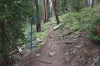
IMG_9725.jpg
 
The ones in the Uintas definitely aren't trail markers. Some of them are right on the trail, others are 30 or 50 feet away in the forest. Sometime they're 10 feet apart, others they're several hundred feet apart.
 
Surveyors often mark a tree or other suitable landmarks to signify a nearby survey point, at least they used to.
 
I know they mark some trees that have been hit by beetles and others that pose threats of falling etc. Did the trees look sick? When I stayed at Butterfly a few weeks ago all the trees that had ribbons or paint were sickly looking and some had fallen including a nice widow maker in our campsite. Maybe they're planning on thinning out some trees to lessen the amout of fuel.
 
I know they mark some trees that have been hit by beetles and others that pose threats of falling etc. Did the trees look sick? When I stayed at Butterfly a few weeks ago all the trees that had ribbons or paint were sickly looking and some had fallen including a nice widow maker in our campsite. Maybe they're planning on thinning out some trees to lessen the amout of fuel.

Nope. They were on everything from nice healthy trees to sickly ones to tiny little saplings...
 
sometimes they are part of environmental surveys too - to show where they've been already and such. when they are surveying plant species, weeds, etc... but i think they are all different.
 
I know for a fact they can be used to mark beetle kill as noted above. But I'm sure that's not the only reason.
 
There are markers all over the sides of the first couple miles of the Stillwater trail from Christmas Meadows. When I was returning from Ryder Lake yesterday I noticed stakes on each side of the trail that said Road 12. Has anyone heard anything about plans for a road going through there? I imagine it would be a jeep road or ATV trail not a paved road, but if that's really what they intend to do, that's an outrage.:mad: Does anyone have any Forest Service friends that might know?
 
There are markers all over the sides of the first couple miles of the Stillwater trail from Christmas Meadows. When I was returning from Ryder Lake yesterday I noticed stakes on each side of the trail that said Road 12. Has anyone heard anything about plans for a road going through there? I imagine it would be a jeep road or ATV trail not a paved road, but if that's really what they intend to do, that's an outrage.:mad: Does anyone have any Forest Service friends that might know?

this makes me wonder if it may be part of the state of utah's claim to all of the supposed "backcountry roads" that they want control over.
 
this makes me wonder if it may be part of the state of utah's claim to all of the supposed "backcountry roads" that they want control over.

Maybe. It seems absolutely senseless to put a road in there. They would only be able to take it up to the wilderness boundary anyway, which is about 2 1/4 miles from the trailhead. At one point the markers veer away from the trail into the woods, so if this really is a proposed road it would mean big changes for the area. There are ATV trails nearby, which makes me wonder if they're planning to expand them. Nothing says wilderness experience like a bunch of ATV's whipping by.:rolleyes:
 
this makes me wonder if it may be part of the state of utah's claim to all of the supposed "backcountry roads" that they want control over.

Hmmm... waste tons of money paying surveryors to go out and mark old 'routes' just to try and call them existing roads to prevent wilderness expansions?? Yeah... that sounds like something the Utah state gov would do. :facepalm:
 
Hmmm... waste tons of money paying surveryors to go out and mark old 'routes' just to try and call them existing roads to prevent wilderness expansions?? Yeah... that sounds like something the Utah state gov would do. :facepalm:

exactly, and it's a huge issue right now as they try to name the most absurd routes as state roads so that they can wrestle control of them from the federal government.

according to the SUWA site, there are over 17,000 'roads' which Utah is currently suing the fed's for control over. seventeen thousand!
 
SUWA is not exactly an 'unbiased' source....and they certainly aren't above stretching the facts

The attorney general's office backs those numbers up... they're not ashamed of it. It's inflated though as it deals with road "segments" and not entire stretches of road as we tend to think of them.

The debate over RS 2477 roads or rights-of-way is a worthwhile one to have, but I highly doubt that's what the tree markers mean.
 
there's no rs 2477 claims in summit county, from what i can gather. my guess is it is related to an EIS on noxious weeds or pine beetle infestation.

curious to see what turns up.
 
there's no rs 2477 claims in summit county, from what i can gather. my guess is it is related to an EIS on noxious weeds or pine beetle infestation.

curious to see what turns up.

There were a lot of beetle traps in the area so that is a good possibility..
 

Similar threads

Back
Top